Charlotte-Mecklenburg Historic Landmarks Commission

Survey & Research Reports

Alexander, Jennie Duplex

This report was written on November 5, 1986


1. Name and location of the property: The property known as the Jennie Alexander Duplex is located at 1801-1803 East Eighth Street, Charlotte, North Carolina.

2. Name, address and telephone number of the present owner of the property: The owner of the property is:

Mr. Lyman Welton & Wife, Katherine S. Holliday
1803 E. Eighth St.
Charlotte, N.C., 28204

Telephone: 704/374-0294

3. Representative photographs of the property: This report contains representative photographs of the property.

4. A map depicting the location of the property: This report contains a map which depicts the location of the property.


5. Current Deed Book Reference to the property: The most recent deed to this property is recorded in Mecklenburg County Deed Book 4307, Page 755. The Tax Parcel Number of the property is: 127-013-01.

6. A brief historical sketch of the property: This report contains a brief historical sketch of the property prepared by Dr. William H. Huffman.

7. A brief architectural description of the property: This report contains a brief architectural description of the property prepared by Thomas W. Hanchett.

8. Documentation of why and in what ways the property meets the criteria for designation set forth in N.C.G.S. 160A-399.4:


a. Special significance in terms of its history, architecture, and/or cultural importance: The Commission judges that the property known as the Jennie Alexander Duplex does possess special significance in terms of Charlotte-Mecklenburg. The Commission bases its judgment on the following considerations: 1) the Jennie Alexander Duplex, erected in 1922, might be the oldest suburban residence in Charlotte which was initially designed as a duplex; 2) the Jennie Alexander Duplex was designed by James Mackson McMichael, an architect of local and regional importance; 3) the Jennie Alexander Duplex is the only known example of McMichael’s residential architecture which survives in Charlotte and is most probably the only example of a McMichael-designed duplex extant in Charlotte; and 4) the Jennie Alexander Duplex is part of a cluster of homes (it, the John Baxter Alexander House, and the Walter L. Alexander House) which once formed a unique family complex in the Elizabeth neighborhood.

b. Integrity of design, setting, workmanship, materials, feeling, and/or association: The Commission contends that the architectural description included in this report demonstrates that the property known as the Jennie Alexander Duplex meets this criterion.

9. Ad Valorem Tax Appraisal: The Commission is aware that designation would allow the owner to apply for an automatic deferral of 50% of the Ad Valorem taxes on all or any portion of the property which becomes “historic property.” The current appraised value of the improvement is $83,800. The current appraised value of the .459 acres of land is $14,000. The total appraised value of the property is $97,800. The property is zoned R6MF.

Date of Preparation of this Report: November 5, 1986.

Prepared by:
Dr. Dan L. Morrill
Charlotte-Mecklenburg Historic Properties Commission
1225 S. Caldwell St. Box D
Charlotte, N.C., 28203

Telephone: 704/376-9115


A Historical Sketch of the Jennie Alexander House
 

by
Dr. William H. Huffman
September, 1986

Walking or riding along East Eighth Street on the part that passes through the tree-shaded Elizabeth neighborhood, one encounters a house on the corner of Lamar Avenue that is rather different most of its neighbors. The duplex at 1803 East Eighth is the former residence of Jane J. (Jennie) Alexander (1861-1932), who had the house built in 1922.

Jennie Alexander was born in Monroe, N.C. at the beginning of the Civil War in 1861. She was the daughter of Dr. Cook Alexander (d. 1882) and Sarah Coburn Stewart Alexander (d. 1902), who had moved to Charlotte from Union County prior to the hostilities, but removed to Monroe for the duration. After the war, the Alexanders returned to Charlotte, where they eventually established themselves as one of the wealthiest and most prominent families of the city. Jennie Alexander, her three brothers (Walter Stewart, William Coburn, and John Baider), and two sisters (Lucy and Mary) all bought and sold real estate in the city, but brothers W. S. and J. B. became two of the most important real estate developers in turn-of -the-century Charlotte.1 It is said that W. S. Alexander (1858-1924) was the first in the city to make the real estate business a profession. In 1899, with Peter Marshall Brown (1859-1913), he organized the Southern Real Estate, Loan and Trust Company, and served as its president from 1908 until his death in 1924, when his brother J. B. Alexander took over the top post. Through his control of the Highland Park Company, W. S. Alexander began the development of the first part of the Elizabeth neighborhood in the late 1890s, in the area on each side of Elizabeth Avenue. By the time the electric trolley line was extended from the Square to Elizabeth College at the top of the hill a mile south of the city in 1903, development of the suburban area began to move at a faster pace.

Two areas just to the north of Elizabeth Avenue began development in 1900, Piedmont Park and Oakhurst, and in 1904, through the Highland Park Co., John B. Alexander and his nephew, W. L. Alexander (Walter’s son) opened up an extension of the original Elizabeth Avenue development to the southeast, which they called Elizabeth Heights. In the Teens and Twenties, many of the city’s prominent citizens as well as outer middle class families built houses in the Elizabeth neighborhood. 3

In 1906, John D. Alexander bought a whole block of land in the Elizabeth Heights section from the Highland Park Company for $3,600.00, which was bounded by Clement, 8th and Lamar on three sides, and the Oakhurst development on the fourth (roughly where Ninth Street would be if it went through). He intended this block to be where he and his family would build their homes, and in 1913 he built a spacious one for himself on the corner of Clement and 8th Avenues.5 Two years later, nephew W. L. Alexander built his own on Clement just up from Eighth Street6 and in 1921, Jennie Alexander bought a 100 x 200 foot on the comer of Lamar and Eighth from J. B. for her new house.7

To design the new residence, Jennie Alexander hired J. M. McMichael, one of the city’s leading architects James Mackson McMichael (1870-1944) was a Pennsylvania native who came to Charlotte in 1901. He was best known for many of the fine churches he designed in his career, many for black congregations. In Charlotte, some of his most important commissions include the old Charlotte Public Library (now demolished), and its companion building on North Tryon Street, the former First Baptist Church, now Spirit Square, the Little Rock A.M.E. Zion Church, now the Afro-American Cultural Center; the Tabernacle A.R.P. Church on Trade Street, the Myers Park Presbyterian Church, St. John’s Baptist Church on Hawthorne Lane; and the North Carolina Medical College building at Poplar and Sixth Streets. In all, McMichael designed twenty-two churches and some one hundred eighty-seven buildings in the Charlotte area, and hundreds more throughout the country. 9 For her residence, Jennie Alexander had McMichael design a duplex, which is believed to be the first one in the city.10 After its completion in 1922, W. S. Alexander’s unmarried daughter, Minnie, moved in with her Aunt Jennie in what they named The Pines.11 The other part of the house was rented to various tenants. For ten years Jennie Alexander enjoyed the peaceful living in that serene part of Elizabeth.

At her death in 1932, Jennie Alexander, who was an active in the Presbyterian Church through her membership in First Presbyterian, as were the other members of her family, willed money to a number of Presbyterian missions and institutions, but her real estate was divided between her brother, J. D, and her nephew.12 For the next twenty years, the house remained in the ownership of her heirs, who in 1952 sold it to Thomas and Comelia Haughton. The present owners bought the property from Mrs. Haughton, then a widow. in 1980. 13 The Jennie Alexander House, through its association with the Alexander family, its place in Elizabeth, and designed by J. M. McMichael is an important thread in the fabric of the city’s history.


Notes

1 Charlotte Observer, Apr. 18, 1932, p. 4; May 30, 1924, p. 1.

2 Ibid; Charlotte Observer, July 28, 1943, p. 12.

3 Thomas Hanchett, “Charlotte Neighborhood Survey”, Charlotte Mecklenburg Historic Properties Commission, 1984.

4 Deed Book 216, p. 16, 4 Sept. 1906.

5 Brochure, “A Tour of Historic Elizabeth”, Charlotte Mecklenburg Historic Properties Commission, 1984.

6 Ibid.

7 Deed Book 454, p. 158, 18 Nov. 1921.

8 City of Charlotte building permit 3505, 22 Dec. 1921.

9 Information on file at Charlotte Mecklenburg Historic Properties Commission; brochure, Historic Architecture Foundation,Washington, D. C, 1984.

10 Ibid.

11 Charlotte Observer, May 30, 1924, p. 1.

12 Will Book W, probated, 22 Apr. 1932.

13 Deed Book 1559, P. 123, 29 May 1952; Deed Book 4307, p. 755, 30 May 1980.


ARCHITECTURAL DESCRIPTION
 

By Thomas W. Hanchett

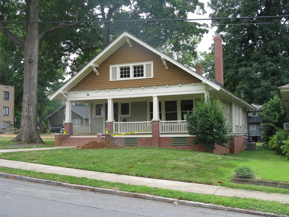
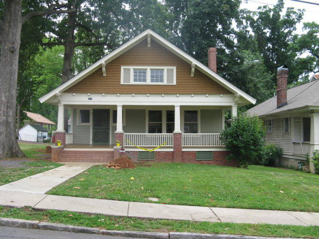
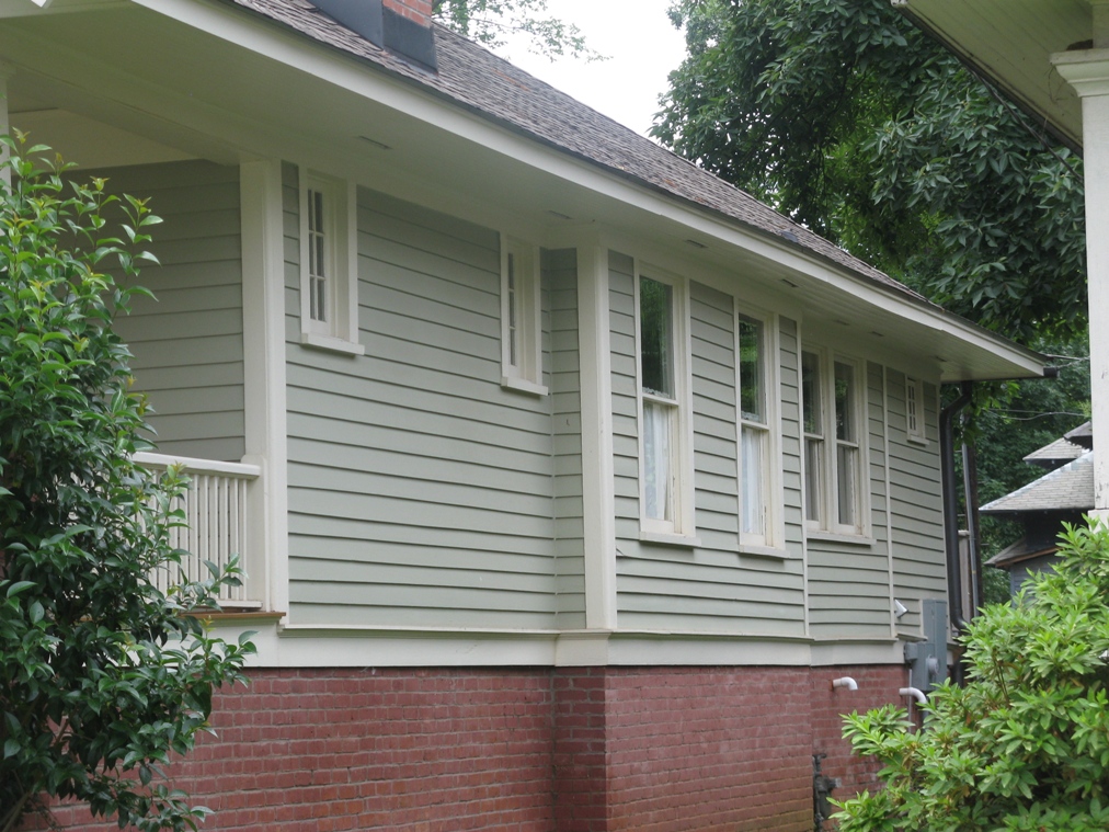
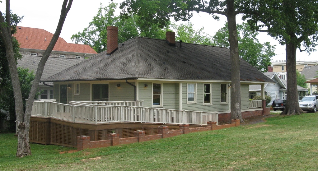
The Jennie Alexander Duplex is one of three large dwellings built in this block during the 1910s- 1920s for members of the Alexander family, the family who guided the development of the surrounding “streetcar suburb” of Elizabeth. Like the J. B. Alexander House and the W. L. Alexander House around the corner on Clement Avenue, Jennie Alexander’s residence shows influence of the Bungalow architectural style. It is a two-story weatherboarded structure, built as a”side-by-side” duplex,with wide bracketted eaves and chunky brick-columned porches. In both its interior and exterior, the dwelling remains in very good original condition, and the original servants’ quarter (also a duplex) may still be seen behind the house.

The Exterior:

The Elizabeth neighborhood boosted a number of owner-occupied duplexes in the 1920s, particularly on Greenway Avenue, but the Alexander Duplex is by far the largest example of the genre. The duplex sits on a slight rise at the corner of East Eighth Street and Lamar Avenue, with both units fronting on Eighth. The main block of the house consists of a two-story rectangle with a two-story wing set back at each side. A pair of large one-story front porches nestle in the niches created by the set-backs. The “west unit” of the duplex has a small, gabled, one-story kitchen and porch wing at the rear. The “east unit” has a larger rear kitchen wing, plus a one-story hip-roofed library wing which extends from the east side of the duplex.

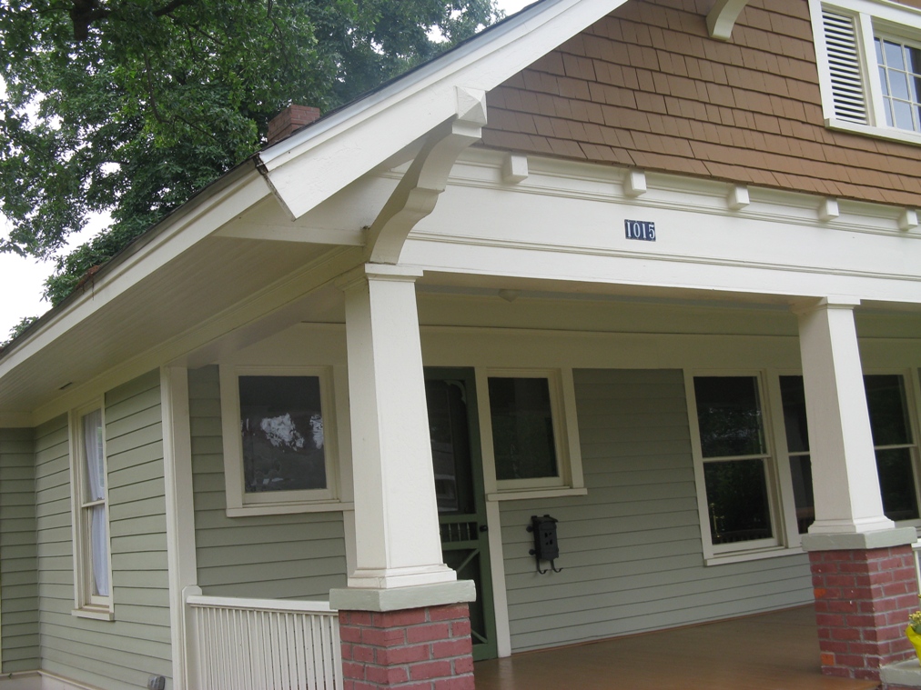
The main block of the structure has hip roofs. The unusually wide eaves are supported by paired triangular brackets made of large squared timbers. There are two brick chimneys located between the units: an interior chimney near the center of the front roof, and an exterior chimney at the center of the rear facade. Windows have wide surrounds edged in simple molding. Panel blocks are added below the corners of the surrounds for a decorative effect. The windows themselves are double-hung sash units, and most have six panes in the upper sash with one large pane in the lower. An exception is found in the first-floor front facade, which has a pair of tripartite windows, each made up of a central six-over-one-pane unit flanked by two four-over-one-pane units. By the way, the library wing at the east side of the house has windows and surrounds which match the main structure, which is an indication that the wing may have been part of the original design.

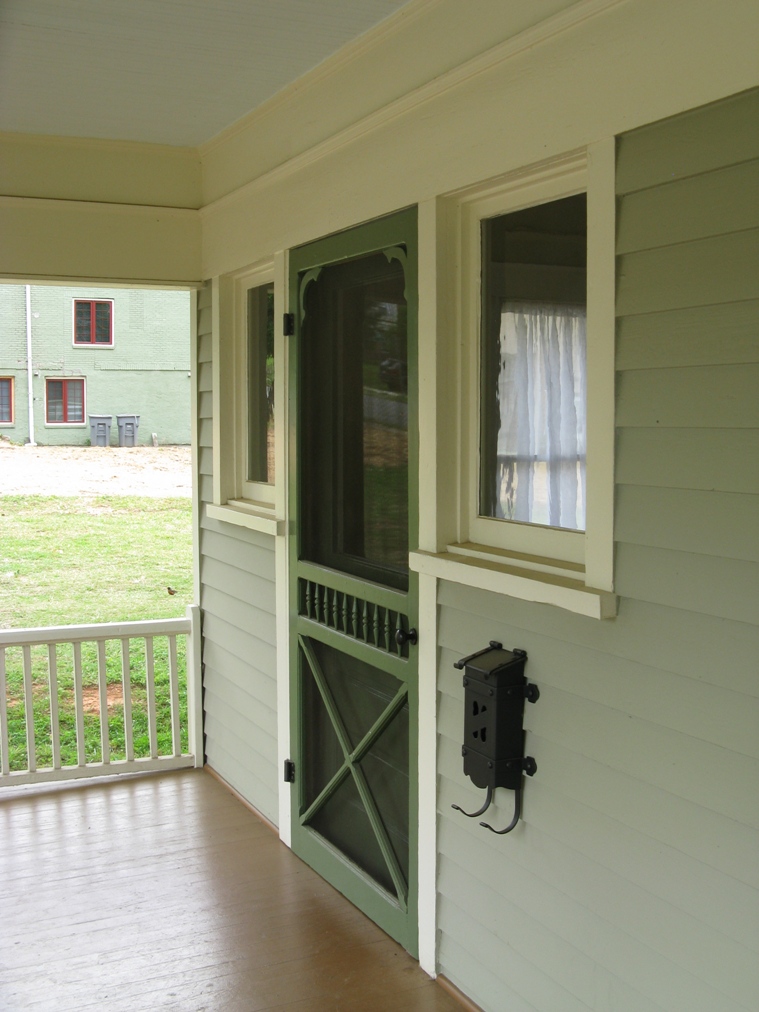
The front porches of the duplex are prominent architectural features. Thick red brick columns with corbelled decoration at the tops support the corners. On each set of columns rests a flat porch roof, supported by both curved and triangular brackets. A simple balustrade with square balusters rings the roof, allowing it to be used as a balcony, and in fact a door opens onto it from the upstairs hall. A similar balustrade protects the main level of the porch. Brick steps lead from each porch down to a concrete sidewalk to the street, and this brick blends into the brick of the structure’s foundation.

The Yard and the Servants’ Quarter:

Before moving inside the main house, we will look briefly at the yard and at the Servants’ quarter. The main house sits back from Eighth Street approximately forty feet, in line with its neighbors, and near the center of its lot. Along Eighth Street and Lamar Avenue there is a low concrete wall approximately a foot high with a curved front face. Such walls were found elsewhere in Charlotte’s desirable early-twentieth century neighborhoods, including Dilworth and Fourth Ward, but rarely survive in good condition today. Behind the house is a new wooden fence shielding a newly landscaped back yard. In the back yard is the original servants’ house, a one-story gabled structure similar in form to mill housing of that day. Simple brackets in the eaves and weatherboarded wall section of the main house. The dwelling was originally a duplex, with two front doors. Today the doors remain, but the interior has been gutted and rebuilt under the design direction of owner Katie Holliday as a “bed and breakfast” unit. This early 1980s remodeling also included complete rebuilding of the quarter’s front porch, extension of its rear garage, and addition of a standing-seam sheet metal roof.

The Interior of the “West Unit”:

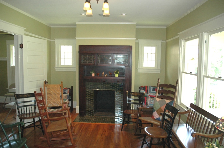
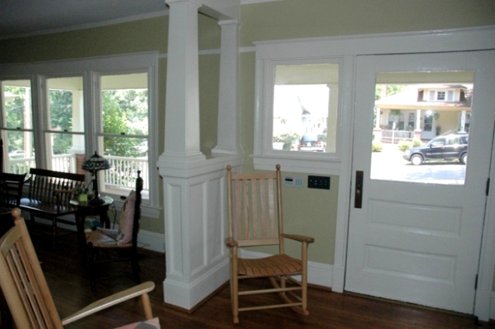
Looking first inside the “west unit,” we enter through the front door into a stair hall. It contains its original light fixture, a hanging globe. A handsome stair winds up the outside walls. It has a heavy balustrade and square newel with paneled sides and a bowl-like carved top piece. From the stair hall, doorways open into the living room, the dining room, and the breakfast room, giving the first floor an open feeling which is reinforced by the light spilling in from the many windows.

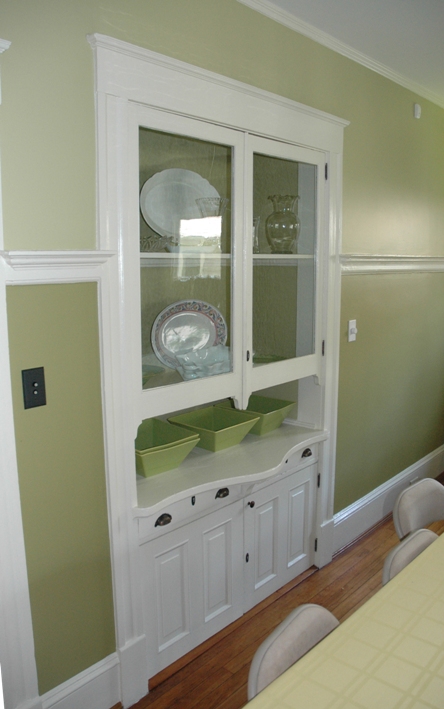
The living room at the front of the house has a wide molded baseboard and a small molded cornice,motifs which are carried throughout the house. A fireplace with a effirgian mantle of red brick and white wooden molding dominates the east wall. French doors in the opposite wall open onto the front porch. The north wall is actually a large opening to the dining room. The opening is flanked by a pair of large square Bungalow-style columns, and is topped by an oversized frieze and cornice. Moving through this opening, one enters the dining room. It continues the decor of the living room, and retains its original cast-metal hanging light fixture. Next to the dining room is a breakfast room, somewhat larger than the “breakfast nooks” typically found on houses of this vintage. The current owners have a molded chair rail here which blends well with the original trim. Behind the breakfast room is the kitchen, the only major room with no cornice molding. The kitchen sink unit and stove appear to date from the 1940s. One corner of the room was long ago walled off for a toilet. At the back of the kitchen is one door to a small pantry, and another door to the small enclosed rear porch.

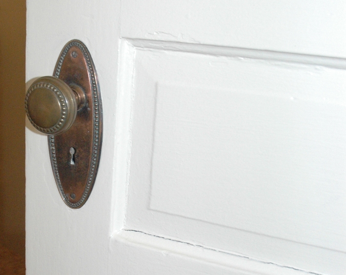
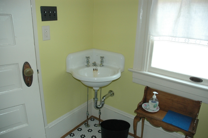
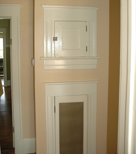
Upstairs in the “west unit” is a stair hall containing a closet, a door to the front porch roof, and doors to the bedrooms and bathroom. Doors are four-panel units with two small upper panels above two long lower panels. The front bedroom is the master bedroom. It contains a Doric-columned mantel over a fireplace with a cast iron coal grate. A pair of simple electric sconces next to it were designed to light a dressing table. The room contains one closet. Behind the master bedroom is a similarly-sized second bedroom, also with a closet but without a fireplace. The current owners have cut a new door from this room into the “east unit” of the duplex, allowing passage from one side of the duplex to the other. Across the hall from the back bedroom is a much smaller room that may have originally served as a sewing room or child’s bedroom. At the back of the hall is the well-appointed bathroom. It retains its original tub, toilet, white tiled wainscoting, and built-in medicine cabinet with an unusual mirrored “Dutch door.” The only major change have been new sconces flanking the medicine cabinet, and a new pedestal sink in recent years.

Dissimilarities Between the “East Unit” and the “West Unit”:

According to the current owners, a thick brick wall separates the two sides of the duplex, providing a sound and fire barrier. The “east unit” of the duplex is identical to the “west unit” in its molding and mantles, but slightly different in its floor plan. On the first floor, the dining and living rooms are almost the same, except that they are separated by French doors rather than a columned opening. The current owners have added a molded chair rail in the dining room. The stair hall is similar, but the stairs wind in a different direction. Next to the stair hall is the library, not found in the “west unit,” with its own bathroom (original fixtures and tile –except for a new sink — match those seen elsewhere in the house). Behind the stair hall and next to the library is a breakfast room of quite different layout than in the “west unit.” The breakfast room contains an original built-in china cabinet. Behind the breakfast room is a spacious kitchen, with a new chair rail, and with rear doors that lead to a pantry and to an enclosed rear porch. On the second floor of the “east unit,” the two main bedrooms are similar to those already described. But the bathroom is slightly bigger and there is no “sewing room” opening off the upper stair hall. Instead a small room that may have been a nursery opens off the bathroom.


For more information…

Survey & Research Report: John Baxter Alexander House

Survey & Research Report: Walter Alexander House


This report was written on March 4, 1981

1. Name and location of the property: The property known as the Isaac Newton Alexander Mill Ruin is located along the banks of Briar Creek on the campus of Myers Park High School in Charlotte, NC.

2. Name, address, and telephone number of the present owner of the property: The present owner of the property is:

The Charlotte-Mecklenburg Board of Education
Education Center
PO Box 30035
Charlotte, N.C. 28230

Telephone: 704/379-7000

3. Current Deed Book Reference to the Property: There is no individual deed listed for this property. The Tax Parcel Number of the property is: 175-071-02.

4. Representative Photographs of the Property: This report contains representative photographs of the property.

5. A map depicting the location of the Property: This report contains a map which depicts the location of the property.


6. A brief historical sketch of the Property: In July and August 1857, Isaac Newton Alexander (1808-1892), a native of the Clear Creek community of Mecklenburg County, purchased a large tract of land along Sugar Creek and along Little Sugar Creek, now Briar Creek, in the Sharon section or Mecklenburg County. 1 Soon thereafter, a water-powered grist mill was erected on his farm It was a two-story frame building which rested upon a rock foundation. 2 Mr. Alexander, a farmer, did not operate the mill but brought “millers” to his farm to oversee the gathering and grinding of grain into flour and meal. 3

The Isaac Newton Alexander Mill served the farmers of the surrounding countryside, who brought their wheat and corn, the principal grain crops of ante-bellum Mecklenburg to the facility for processing. 4 It must have been a hubbub of activity. As late as 1880, the mill was in full operation, not only processing grain but also producing cottonseed oil, the first in Mecklenburg County, peanut oil and castor bean oil. 5 But in the late 1880s and 1890s, more efficient plants, such as a roller mill in Dilworth, made the Isaac Newton Alexander Mill obsolete, and the old building fell silent. 6 On August 28, 1896, the Charlotte Observer reported that the mill dam “at the old Captain Alexander mill” had been washed away by heavy rains. “It was swept completely away,” the newspaper noted. “The people in that neighborhood think it a good riddance.” 7

Isaac Newton Alexander died on November 18, 1892. 8 A member and long-time elder at Sharon Presbyterian Church, he was buried in the Sharon cemetery beside his wife, Caroline Morrison Alexander (1825-1863), whom he had wed on August 8, 1845. 9 The Charlotte Democrat described him as a “good Christian man”. 10 The Charlotte Weekly Observer was even more expansive in its praise of Isaac Newton Alexander, “His walk in life was that of an honest man and exemplary Christian,” the newspaper declared. 11 Cyrus Morrison Alexander, his son, who was associated with the mill operation, lived until March 6, 1947. 12

In the early 1950s, when Myers Park High School was built, Dr. E. H. Garinger, Superintendent of the Charlotte Schools, suggested that the art building and the history building be located near the mill ruin. Also, local chapters of the United Daughters of the Confederacy advocated the restoration of the mill. Neither of these proposals materialized. 13 The Isaac Newton Alexander Mill is a unique element in the built environment of Charlotte. Unhappily, only remnants of the complex survive. The mill pond extended northward on Briar Creek, covering most of what is now the golf course of Myers Park Country Club. The rock dam was about fifteen feet high. 14 Just above the mill, one can see traces of the flume or rock-lined trench which brought the water to the overshot or breastshot wheel that powered the grinding apparatus. The dressed millstones, both the runner stone and the bedstones, are extant, but in 1969 they were moved to a spot near the entrance to Myers Park High School.


Footnotes

1 Mecklenburg County Deed Book 3, Page 803. Mecklenburg County Deed Book 3, Page 809-810. Gravestone of I. N. Alexander in the Cemetery at Sharon Presbyterian Church. “Mecklenburg County – Watermills ” (a folder in the vertical files of the Carolina Room of the Charlotte-Mecklenburg Public Library).

2 Letter from Mr. Beaumert Whitton to the Charlotte-Mecklenburg Historic Properties Commission (May 7, 1979).

3 The United States Census reveals that at least three millers operated the facility. Burton Flanigan (1860 Census, p 21-23); Eli Blackwelder (1870 Census, p. 265); George A. Cook (1880 Census, p. 533).

4 Western Democrat (June 2, 1857), p. 3.

5 1880 Census, p. 533. “Mecklenburg County- Watermills”.

6 Charlotte Observer (November 26, 1985), p. 4.

7 Charlotte Observer (August 28, 1898), p. 5

8 Gravestone in the Cemetery at Sharon Presbyterian Church.

9 Mecklenburg County Marriage Bonds, p, 4. Gravestone of Caroline Morrison Alexander in the Cemetery at Sharon Presbyterian Church.

10 Charlotte Democrat (November 25, 1892), p. 3.

11 Charlotte Weekly Observer (November 21, 1892), p. 4. There is also an obituary article for him in the Charlotte Observer (November 19, 1892), p. 1.

12 Charlotte News (March 3, 1947). Charlotte Observer (March 8, 1947), p. 3.

13 “Mecklenburg County- Watermills”

14 Charlotte Observer (August 28, 1898), p. 5.


7. A brief architectural description of the property: This report contains an architectural description of the property prepared by Jack O. Boyte, AIA.

8. Documentation of why and in what ways the property meets the criteria set forth in NCGS 160A-399.4:


a. Special significance in terms of its history, architecture, and/or cultural importance: The Commission judges that the property known as the Isaac Newton Alexander Mill Ruin does possess special significance in terms of Charlotte-Mecklenburg. the Commission bases its judgment on the fact that this is one of the few mill ruins which survive in Mecklenburg County and the only one of this type in this section of the city and county.

b. Integrity of design, setting, workmanship, materials, feeling and/or association: The Commission judges that the architectural description included herein demonstrates that the property known as the Isaac Newton Alexander Mill Ruin meets this criterion.

9. Ad Valorem Tax Appraisal: The Commission is aware that designation would allow for the owner to apply for an automatic deferral of 50% of the Ad Valorem taxes on all or any portion of the property which becomes “historic property”. The current Ad Valorem appraisal on the 72.9 acres of land is $5,789,320. The current Ad Valorem appraisal on the improvements is $4,181,270. The property is exempt from the payment of Ad Valorem taxes.


Bibliography

Charlotte Democrat.

Charlotte News.

Charlotte Observer.

Charlotte Weekly Observer.

Gravestones in cemetery at Sharon Presbyterian Church.

Letter from Mr. Beaumert Whitton to the Charlotte-Mecklenburg Historic Properties Commission (May 7, 1979).

Mecklenburg County Marriage Bonds.

“Mecklenburg County – Watermills” (a folder in the vertical files of the Carolina Room of the Charlotte-Mecklenburg Public Library).

Records of the Mecklenburg County Register of Deeds Office.

Records of the Mecklenburg County Tax Office.

United States Census (1840, 1850, 1860, 1870, 1880).

Date of Preparation of the Report: March 4, 1981.

Prepared by: Dr. Dan L. Morrill, Director
Charlotte-Mecklenburg Historic Properties Commission
3500 Shamrock Dr.
Charlotte , NC 28215

Telephone: 704/33-2726.


Architectural Description
 

by Jack O. Boyte, AIA

Charlotte has within its city limits numerous historic sites of value and significance. While many retain only a suggestion of their original form, there is one whose land and structural remains are surprisingly undisturbed; the Isaac Newton Alexander grist mill. Obscured and protected by rough terrain and thick underbrush, the massive granite foundation walls of this mid-nineteenth century grist mill remain much as they were when first erected in the red clay hillside of the Briar Creek valley where it passes Myers Park High School.

Passing years have seen continuing damage to the mill remains. There are mounds of stone rubble around the base of the walls. Here and there in the rubble are rectangular granite blocks which were once part of the tall ashlar walls of the structure.

The foundation walls outline in clear relief the size and shape of the mill house, and the surrounding earth forms illustrate original shapes of the wheel well, water canals and diversion ditches. Evidence remains to tell of roads and ramps as well as the original tail race where lowered water returned to the creek.

The main body of the structure is approximately twenty-five feet wide and thirty feet long. Three foot thick foundations of random granite ashlar follow this shape along an east-west axis. The east end is buried in the hillside. And here is the tallest remnant of the original wall. More than twelve feet high, the wall stands straight and solid against earth pressure just as it has since 1850.

South of the main building are stone remnants of a wing which measures some ten feet square. This appendage, likely floored at the same level as the main structure, was probably used to divert incoming grain to the lower level for transfer to the mill stone grain hoppers.

On the upstream side of the building there is a huge excavated channel as long as the house. Rubble stones line the sides and most remain as they were when the mill was first built. Deep and wide enough for a water wheel of twelve or more feet in diameter, this well indicates that the mill power came from an overshot wheel, though the evidence now seen could also hint of a much larger breast wheel.

The creek valley, which forms a wide sweeping arc for several miles above the mill site, is lined with steep rocky sides. Isaac Alexander obviously found the site well suited for a dam and mill pond, for he established an extraordinary grist mill in the valley. And though it no longer exists, the location of the Alexander mill pond is identified by remnants of a water canal which reached from the pond to the mill. This shallow ditch, still visible on the brow of the southern creek bank, was about an eighth of a mile long. Its depth and width were determined by the water supply required to adequately fill the wheel buckets as the mill operated. Water flow was controlled by baffles and diversion channels in the canal. Still evident, just above the mill, is a deep secondary spillway through which canal water was directed when the miller chose to vary the wheel movement. The lower level, or ground floor, of the mill appears to have been a stone enclosed grinding area. Above this was a wooden upper floor where grain was received and the prepared meal was sacked and stored. Mounted high in the north wall of this room, the water wheel axle transmitted power to the mill stones through a series of wood and iron gears. Fortunately, students of the nearby high school salvaged both the bed stone and the grind stone from the mill site soon after the school was completed in the late 1950s. These valuable artifacts are on permanent display in the school yard and appear relatively intact.

Stones which have diameters of about four feet illustrate important elements in the construction of the Alexander grist mill. At the same time they demonstrate the skill of the stone cutter who shaped and furrowed the grinding stone.

The upper floor of the building, which was level with the old road bed, contained two or more rooms. Here farmers delivered grain for grinding and meal was bagged or stored. Here, also, there were quarters and offices for the miller, who often operated the equipment around the clock. The wooden structure has all vanished, so its form must be conjectural until research completed the accurate story of this important old building.

This relic is a graphic reminder of a popular home industry in early Mecklenburg. The streams around Charlotte were repeatedly used for mill power in the eighteenth and early nineteenth centuries. With the advent of steam power after the Civil War, most mills fell into disuse and have disappeared. So this site, protected as it is by its location and situated on public land, presents an extraordinary opportunity to preserve a permanent and significant part of our pioneer heritage.


Hezekiah Alexander House

Hezekiah Alexander House

Hezekiah Alexander House


Hezekiah Alexander was born January 13, 1722, in Cecil County, Maryland. He was the son of James Alexander and Margaret McKnitt. His grandfather, Joseph Alexander, had emigrated to Maryland in the early years of the eighteenth century. Sometime after 1754, Hezekiah, as well as his brother, John McKnitt, emigrated to North Carolina.

The Alexanders quickly established themselves in their new home, Mecklenburg County. Although Hezekiah had come to North Carolina as a blacksmith, it was as a farmer that he made his fortune. On April 1, 1767, he purchased, from his brother John, a tract of land containing over three hundred acres located on a branch of Sugar Creek. It was here that in 1774 he built a stone house to accommodate his wife, Mary Sample, and their growing family. The house was to remain Hezekiah’s residence until his death in 1801, and became the center of his expanding farming enterprises. Both Hezekiah and John McKnitt Alexander were active in the affairs of their county. John was a crown surveyor and county magistrate. Hezekiah played an active role in the church, being an elder in the Sugaw Creek Presbyterian Church. He was also a trustee of Queens College, chartered in 1771, renamed Liberty Hall in 1774. Both brothers numbered among their friends and associates the prominent community leaders of Mecklenburg; among these were Thomas Polk, William Sample, Ephraim Brevard, the Phifers, the Averys, and Jeremiah MaCafforty.

With the approach of the Revolution, both of the Alexander brothers became increasingly involved in the events which would culminate in independence from Great Britain. In 1775 both men were members of the Mecklenburg County Committee of Safety. On August 21, 1775, Hezekiah was appointed by the Provincial Congress meeting in Hillsborough to the Salisbury District Committee of Safety which was to serve as the local governing body for a multi-county area. In November, 1776, Hezekiah joined other state delegates at Halifax to form the Fifth Provincial Congress which was charged with the task of writing the first state constitution. After the Halifax Congress, Hezekiah joined the Fourth Regiment of North Carolina Troops as Paymaster.

Hezekiah Alexander’s stone house is possibly the only extant structure belonging to a framer of the state’s first constitution.

Architecturally, the Hezekiah Alexander House reflects the influence of the German emigrants who came to North Carolina from Pennsylvania in the 1750s and 60s. During that period several thousand families settled in Mecklenburg and the adjoining counties. Many of those settlers constructed houses of native stone similar to that of Alexander’s. They were quite similar in form to houses built by the Germans in Pennsylvania and the Dutch in the Hudson Valley. The Hezekiah Alexander House is one of the few surviving examples of this architectural type in North Carolina.

Exterior: The Hezekiah Alexander House was constructed of native Piedmont stone in a random pattern with oyster shell mortar. The walls are two feet thick. The structure is two full stories over a high basement. The front and rear facades are each of three bays with contour doors. The attic is lit by a pair of small windows in the west gable and one in the northeast corner of the east gable. The windows are six-over-six in configuration, all having batten shutters. Segmental arches were originally constructed over all windows and doorways. Those on the front and rear facades have keystones. Some of these arches were eliminated during alterations to the house, probably at sometime during the nineteenth century. In the west gable there is an intersecting blind round window. The roof is now covered with asbestos shingles; originally it was covered with cypress shakes. The wide overhang of the eaves is not original. The exterior dimensions of the house are length 36′ 5″ and width 35′ 5″.

Interior: The present interior plan has one long room across the front of the house with an open stair in one end and a corner fireplace in the other. Originally there was a wooden partition dividing the stair hall from the parlor. The present stair is a replacement from the original enclosed one. Behind this room are two smaller rooms, a kitchen and bedroom, divided by a small passage leading to the rear door. The right-hand wall is one of a later date. Originally there were two rooms of unequal size on the rear. There are corner fireplaces in both rear rooms. The chimney breasts were originally plastered. There is a warming cupboard over the fire place in the right-hand rear room. This room must have been used as the kitchen.

On the second floor there are three rooms and a stair hall. The wall between the stair hall and the room behind it is of dubious form and may not be original. There are no fireplaces on the second floor. The basement is divided into two rooms of unequal size by a transverse stone wall. There is a stair to the second floor and an exterior entrance in the southeast corner if the east room. All ceilings show exposed structural members. All of the stone walls are plastered on the interior. The other interior partitions are


Woodlawn Bungalow

Survey and Research Report
on the

Woodlawn Bungalow 

1015 West Fourth Street, Charlotte

1015_frm_st

1.    Name and location of the property:  The property known as the Woodlawn Bungalow is located at 1015 West Fourth Street, Charlotte, North Carolina.

2.    Name and address of the current owner of the property:

The Committee to Restore and Preserve Third Ward
1001 West First Street
Charlotte, NC

3.    Representative photographs of the property.  This report contains representative photographs of the property
4.    A map depicting the location of the property.

Mecklenburg County Tax Map

1015-4th-st-map

5.  Current Deed Book Reference To The Property.  The most recent deed to this property is found in Mecklenburg County Deed Book 9443, page 998.  The tax parcel number for the property is 07321513.
6.  A Brief Historical Essay On The Property.  This report contains a brief historical sketch of the property prepared by William Jeffers.

7.  A Brief Physical Description Of The Property.  This report contains a brief physical description of the property prepared by Stewart Gray.

8.  Documentation of why and in what ways the property meets the criteria for designation set forth in N.C.G.S. 160A-400.5.

a.  Special significance in terms of its history, architecture, and/or cultural importance.  The Charlotte-Mecklenburg Historic Landmarks Commission judges that 1015 West Fourth Street possesses special significance in terms of Charlotte-Mecklenburg.  The Commission bases its judgment on the following considerations:

1) The Woodlawn Bungalow is a remarkably well preserved example of a Craftsman Style bungalow, typical of the type of house that was constructed for middle class residents of Charlotte in the city’s urban core for a brief period of time in the early 1900s.

2) The Woodlawn Bungalow may very well contain the most complete and best preserved Craftsman Style bungalow interior in the City of Charlotte.

3) The Woodlawn Bungalow is an important element of Woodlawn, an early streetcar suburb, and is a reminder of the early 20th century residential nature of Charlotte’s urban core

b.  Integrity of design, setting, workmanship, materials, feeling and/or association:  The Commission judges that the physical description included in this report demonstrates that the property known as The Woodlawn Bungalow meets this criterion.

9.  Ad Valorem Tax Appraisal: The Commission is aware that designation would allow the owner to apply for automatic deferral of 50% of the Ad Valorem taxes on all or any portion of the property which becomes a designated “historic landmark”.  The current appraised value of the Woodlawn Bungalow meets Street is $185,500.  The property is zoned UR-1.

10.  Portions of the property recommended for landmark designation: This report finds that the interior, exterior, and land associated with the Woodlawn Bungalow should be included in any landmark designation of the property.

Date of preparation of this report:

June 1, 2011

Prepared by:

William Jeffers and Stewart Gray

Third Ward Contextual History

Until the twentieth century, Charlotte’s urban core was a mix of residential and commercial structures.  The most influential of the city’s population clustered along the two main thoroughfares of Trade and Tryon Streets while businesses and commercial structures were interspersed between them.  This pattern had been the norm, more or less, since the town’s founding.  However, as the twentieth century dawned, Charlotte began to undergo a transformation from a quiet courthouse town to a burgeoning metropolitan city.  As a result, the residential patterns of the urban core began to change in ways that would redefine the built landscape of the center city.

Charlotte was organized along a ward system.  Initially divided into four numerically named wards, each had a sizable collection of residential housing.  As the twentieth century progressed this collection of residential dwellings began to take a backseat to the industrial and commercial development that overtook the core.  This phenomenon is typified in the development of streetcar suburbs like Dilworth, and in the creation of the mill village of North Charlotte.  These new neighborhoods began to draw both the affluent and working class residents out of the center of town to points that then were clustered around the periphery of the city.  This transformation, however, did not occur overnight and each ward was affected differently by it.  Fourth Ward retained a strong residential pattern still evident today.   First and Second Ward also had a large number of residential housing.  However, both of these wards have lost much of their historical integrity.  This is painfully evident in Second Ward, where Urban Renewal destroyed the African American community of “Brooklyn,” eliminating all the residential structures of the neighborhood.

Third Ward, like the other wards around it, also contained a combination of residential and commercial structures.  However, “what is now considered Third Ward is made up of two very separate areas.”[4]  The original section of Third Ward was an area that was bordered by, Morehead Street, Graham Street West, and Trade and Tryon Streets.[5] This section of Third Ward followed residential patterns similar to First Ward with a mixture of residential and commercial uses with fewer black residences.[6]

The arrival of the Piedmont and Northern Railroad in the second decade of the twentieth century, precipitated a shift in land use in this ward; so much so that “the area became the least residential of the four wards, with warehousing and commercial uses as its heart and industry on Graham Street along the Southern Railway tracks.”[7]

Following the patterns of other city wards, the edges of Trade and Tryon Streets contained commercial development.  This section of Third Ward, while lacking in residential structures, had several significant industrial and commercial structures such as the now demolished Good Samaritan Hospital (Bank of America Stadium currently resides on the property) and the demolished Piedmont and Northern Railroad depot.  This large railroad terminal, which precipitated the transformation of the ward towards industry, has also succumbed to the wrecking ball.  James B. Duke, president of both the utility company and the railroad, first utilized the site for the headquarters of the Piedmont and Northern.  Eventually, he expanded the structure, building the “headquarters for Duke Power at the front of the lot in 1928.”[8] Another example is the no longer extant Charlotte Supply Building.  Built in1924-1925, the Charlotte Supply Building was a supplier of textile machinery and served as “a well preserved warehouse building of the type that the railroads attracted to Third Ward.”[9]

Extant examples exist in the United States Post Office Building on West Trade Street.  The massive structure, with its signature limestone columns, was built in 1915.[10]  Another is seen in The Virginia Paper Company building on West Third Street.  Constructed in 1937, the building serves as a largely unaltered example of industrial architecture from the 1930’s and also underlines the wards transition from residential/commercial to an industrial area.[11]

Woodlawn Neighborhood

The second section of Third Ward is the residential area between the Southern Railway railroad tracks and Interstate 77.  This area remained undeveloped during much of the city’s early history.[12]  The first structure built in this section was the Victor Cotton Mill (no longer extant).  Constructed in 1884, the mill was located near the intersection of Clarkson Street and Westbrook Drive.[13] Around 1907 the owners of the mill, by then known as the Continental Manufacturing Company, began to develop the surplus land it owned in Third Ward into the neighborhood of Woodlawn through a subsidiary known as the Woodlawn Realty Company.

“The Development of the Woodlawn Neighborhood was part of the phenomenal growth that Charlotte experienced in the early years of the twentieth century.  Between 1900 and 1910, the city’s population grew 82%, from 18,091 to 34, 014.”[14]  As a result, the physical boundaries of the city began to expand out from the original four wards.  In order to accommodate these new citizens real estate developers such as F.C. Abbott, George Stephens, and B.D. Heath built neighborhoods that were linked to the city by the expanding streetcar systems.[15]

The Woodlawn Neighborhood was one of these new streetcar suburbs. While located inside one of the city’s original four wards, the neighborhood was advertised as a suburb, perhaps due to the developing success of Charlotte’s first true streetcar suburb, Dilworth.[16]  With streetcar lines radiating outward from the center of town, new neighborhoods began to develop along the lines.  Woodlawn was one such neighborhood, and it was served by the West Trade Street streetcar line.[17]  The fact that the neighborhood was situated so close to downtown may have been a marketing tool for local developers.  An advertisement in the October, 10, 1911 Charlotte Observer proclaimed that “Woodlawn is the nearest suburb to the business part of the city, yet NONE is prettier.”[18]  Many of the original parcels of land in Woodlawn were bought by J.W. McClung, a realtor who office was located at 25 South Tryon Street[19] McClung also lived in the Woodlawn Neighborhood[20]

The Woodlawn Bungalow

The Woodlawn Bungalow, located at 1015 West Fourth Street, is an exemplary example of a Craftsman Style bungalow.  It is remarkably well preserved, having retained nearly all of its original significant architectural features.  The exterior is largely original with only sensitive changes on the rear to allow for better disabled accessibility.  The interior of the Woodlawn Bungalow is remarkably well preserved.  The interior has retained an extremely high degree of integrity and is in good condition. The ca. 1909 layout of the interior remains virtually intact.  All of the original significant interior architectural features have survived intact, and no significant interior alterations have occurred.  The Woodlawn Bungalow may very well contain the most complete and best preserved Craftsman Style home interior in the City of Charlotte.   The well preserved exterior combined with the exceptional interior imbues The Woodlawn Bungalow with significance as an important artifact of the Woodlawn neighborhood, but also as an important historical architectural asset for the City of Charlotte.

The bungalow form can trace its origins to India.  The house form inspired American  architects in the creation of the Craftsman Style house.  The bungalow form and elements of the Craftsman Style became phenomenally popular in America in the early years of the twentieth century, and continued to be extensively utilized until the advent of the Great Depression.  The bungalow was extremely popular in the American South.  One factor in this popularity was that the bungalow form, with its wide eaves and ample porch, was suitable for hot weather.

The Craftsman Style and the bungalow form were enthusiastically embraced by Charlotte builders during the booming years of the early twentieth century.  While the bungalow was particularly suited for warm weather, it was also suited as a design for smaller middle class homes.  With the ability to combine style, convenience, simplicity, solid construction, and plumbing with a modest construction cost, this type of residence helped many in the early twentieth century achieve the dream of home ownership.  As a result, the Craftsman Style bungalow would become the preferred house for many middle class residents of Charlotte.

The Woodlawn Bungalow was built sometime between 1909 and 1910.  While no building permit could be found giving the exact date, Charlotte City directories list Oscar and Katie Hunter as its first residents in 1910.[22]  The house seemed to have a high degree of turnover, because the 1911 directory lists Locke S. Sloop, a bookkeeper with Charles Moody Company (located at 25 – 31 South College Street)[23], and his wife Nelle as the new residents.[24]  In 1914, J.W. Baynard, a superintendent at F.S. Royster Guano Company (located at 200 South Tryon Street in the Commercial National Bank Building),[25] and his wife Marie[26] lived at the house and would do so until 1920 when J.L. Dew took up residence.[27]  This pattern of residential turnover would continue to be the norm for the Woodlawn Bungalow.  Between the years 1926 – 1943, Charlotte city directories list no fewer than six different tenants at the address.[28]

The high residential turnover rate at the Woodlawn Bungalow may reflect a rapid change in the neighborhood’s character.  By the 1920s the city directories, which generally list the occupations of the residents, demonstrates a significant change in the nature of the neighborhood.  Woodlawn had by the 1920s the city directories, which generally list the occupations  of the residents, demonstrate a significant change in the nature of the neighborhood.  Woodlawn had by the 1920s become less middle class and more working class.  Even though J.W. Baynard was solidly middle class as the superintendent of a large company, the professions that populated the street and the neighborhood at large.  By the 1920s, painters, salesmen, secretaries, and county policemen (to name a few), were distinctly working class.[29]   Virginia Woolard, a childhood resident of Woodlawn stated:  “We were working families, we just worked and worked.  Our lives were not dramatic; it was just the everydayness of things.  We went to church, went to school, and sort of minded your own business.”[30]

Woodlawn, as a neighborhood, never grew past its original layout.  It was built as a white middle class community.  Early deeds confirm as much stipulating that all lots “shall be used for resident purposes and by people of the white race only (a common stipulation in the Jim Crow South); and that no dwelling shall be erected thereon which shall cost less than $1000.00.”[31]   Plotted initially along four streets, it appears that soon after the small neighborhood was built it began to lose its original identity.[32]  Sanborn Maps show the neighborhood listed by the name Woodlawn.  Virginia Woolard, however, recalled that she never knew of the area specifically as “Woodlawn.”  Generally, people would refer to the street on which they lived as a geographic reference rather than using a neighborhood moniker.[33]  As she stated, “when I was growing up I was not aware of the word ‘Woodlawn.’  I didn’t have any concept about any name where we lived.”[34]

Still, there was a sense of community amongst the residents of the area.  One of the reasons for this was the fact that the neighborhood was pedestrian friendly.  Trade Street was the only main thoroughfare in the neighborhood.  Many of the other streets ended at Irwin Creek and were devoid of heavy traffic.  As a result people moved around the neighborhood freely.  As Virginia Woolard related, “I enjoyed visiting, we would go back and forth between each other’s houses.”[35]  The neighborhood had an abundant tree canopy and considering its proximity to downtown Charlotte one “had the sense that you were somewhat isolated” from the rest of the city because of it.[36]

Eventually, this sense of community became eroded.  It began with the renaming of Woodlawn Avenue to South Irwin Avenue.  This was done due to new development outside the city center along the new Woodlawn Road and the name change would help, “to avoid confusion with the robust roadway to the south.”[37]  Furthermore, office and commercial zoning that were arbitrarily put in place along the thoroughfares rendered many existing residences obsolete.  By the 1970s with the construction of new roads, the neighborhood was opened up to heavy vehicular traffic, destroying the “walkable” feel of Woodlawn’s original design.  As the neighborhood lost its identity, coupled with an explosion in suburban construction in the postwar decades of the 1950’s and 1960’s, a steady decline ensued.  As middle class families began to leave the neighborhood, it gradually became populated by working class families, some of whom had left the Brooklyn and First Ward neighborhoods as a result of Urban Renewal programs.[38]

After Urban Renewal parts of Third Ward, including Woodlawn, were considered some of the city’s worst neighborhoods, “populated with liquor houses and ‘fancy houses’ for prostitutes.”[39]

After Urban Renewal parts of Third ward, including Woodlawn, were considered some of the city’s worst neighborhoods, “populated with liquor houses and ‘fancy houses’ for prostitutes.”[39]  The Ward, however, would experience a renaissance.  In 1975, Third Ward was designated as a community Development Target Area.  Under that program Third Ward benefited from housing rehabilitation, as well as street, sidewalk, landscaping and park improvements.[40]  Another key to the revival was the removal of a metal scrap yard between South Cedar Street and the railroad tracks.[41]  New residential development along Cedar and Clarkson Streets, as well as other small scale projects served as further catalysts for this transformation.

Even with all this new development, the Woodlawn neighborhood of Third Ward still retains much of its original historic integrity; well representing an early twentieth century, middle class Charlotte neighborhood.  As Dr. Thomas Hanchett points out in his study of Charlotte’s urban core for the Charlotte-Mecklenburg Historic Landmarks Commission, the Woodlawn section contains, “one of Charlotte’s notable concentrations of early bungalows.  The small frame houses lining Grove and West Fourth Streets between Sycamore and Irwin create a streetscape that today looks much as it did seventy years ago.”[42]  Unfortunatly, across Trade Street in Fourth Ward, a large number of bungalow style houses like the ones in Woodlawn have recently fallen victim to the wrecking ball.  The Woodlawn neighborhood represents the apex of center city, middle class, residential construction in the early twentieth century.  By the 1920’s, middle class residential building trends had shifted away from the center city to residences like the Radcliffe-Otterbourg House in  Colonial Heights and Middleton Homes. Therefore, the near complete loss of historic residential buildings in the Center City makes it difficult for the public to understand the pre-World War II history of Charlotte based on the current built environment.[43]  This dearth of historic residential resources in Charlotte’s urban core gives the surviving neighborhoods, and individual structures within them, historic significance if they have retained their original integrity.  Considering the fact that Charlotte has excellent preserved examples of the upper class experience in Fourth Ward, Eastover, and Myers Park; coupled with the white, working class experience of the North Davidson community and the African American experience in communities like Cherry, the importance of highlighting Charlotte’s middle class experience becomes even more paramount.  The Woodlawn Bungalow was restored in 2010 by the Committee to Restore and Preserve Third Ward.  The house was named the Baxter-Polk House by the neighborhood committee in honor of educator and neighborhood leader Dr. Mildred Baxter Davis and James K. Polk, a leader in minority affairs in Charlotte.  Local landmark designation of the Woodlawn Bungalow can serve as a starting point to rectify this imbalance.

[1] See CMHLC, Old House Style Guide, Charlotte-Mecklenburg Historic Landmarks Commission, http://www.cmhpf.org/kids/Guideboox/OldHouseGuide.html, (Accessed April 12, 2011).

[2] Dan L. Morrill, A Walking Tour of Elizabeth, Charlotte-Mecklenburg Historic Landmarks Commission, http://www.cmhpf.org/educationwalkelizabeth.htm, (Accessed May 10, 2011).

[3] See Morrill, A Walking Tour of Elizabeth, and CMHLC, Old House Style Guide.

[4] Dr. Thomas W. Hanchett, The Center City:  The Business District and the Original Four Wards, Charlotte-Mecklenburg Historic Landmarks Commission, http://cmhpf.org/educationneighhistcentercity.htm (Accessed April 10, 2011).

[5] See Hanchett, The Center City.

[6] Ibid.

[7] Hanchett, The Center City.

[8] Ibid.

[9] Ibid.

[10] See Hanchett, The Center City.

[11] See CMHLC, Survey and Research Report on The Virginia Paper Company Building, Charlotte-Mecklenburg Historic Landmarks Commission, http://cmhpf.org/SurveyS&RVirginia.htm, (Accessed June 8, 2011).

[12] See Hanchett, The Center City.

[13] Third Ward Neighborhood Association, The Committee to Restore and Preserve Third Ward, and the Charlotte-Mecklenburg Planning Commission, A Third Ward Future:  A Land Use & Urban Design Plan for an Uptown Charlotte Neighborhood, Volume 1, July 1997, p. 7.

[14] Stewart Gray, Survey and Research Report on the Woodlawn Avenue Duplex, Charlotte-Mecklenburg Historic Landmarks Commission, http://cmhpf.org/SurveyS&RWoodlawn.htm, (Accessed April 10, 2011).

[15] See Gray Woodlawn Avenue Duplex.

[16] Ibid.

[17] Ibid.

[18] Charlotte Observer, October 10, 1911.

[19] See Ernest H. Miller, Charlotte City Directory, 1911, (Asheville, N.C.:  Piedmont Directory Company, Inc., Publishers, 1911) p. 283.

[20] See Ernest H. Miller, Charlotte City Directory, 1912, (Asheville, N.C.:  Piedmont Directory Company, Inc., Publishers, 1912) p. 294.

[22] See Ernest H. Miller, Charlotte City Directory, 1910, (Asheville, N.C.:  Piedmont Directory Company, Inc., Publishers, 1910) p. 126.

[23] See Ernest H. Miller, Charlotte City Directory, 1911, (Asheville, N.C.:  Piedmont Directory Company, Inc., Publishers, 1911) p. 307.

[24] See Ernest H. Miller, Charlotte City Directory, 1911, p. 523.

[25] See Ernest H. Miller, Charlotte City Directory, 1914, (Asheville, N.C.:  Piedmont Directory Company, Inc., Publishers, 1914) p. 178.

[26] See Miller, Charlotte City Directory, 1914, p. 626.

[27] See Ernest H. Miller, Charlotte City Directory, 1920, (Asheville, N.C.:  Piedmont Directory Company, Inc., Publishers, 1920) p. 790.

[28] See the 1926, 1933, 1934, 1938, 1939, and 1943 Volumes of Hill’s Charlotte City Directory, (Richmond, VA: Hill Directory Co., Inc., Publishers).

[29] Ibid.

[30] Bill Jeffers, Interview with Virginia Woolard.

[31] Mecklenburg County Deed Book 241, p. 486.

[32] See Gray, Woodlawn Avenue Duplex.

[33] See Stewart Gray, Conversation with Virginia Woolard, October 2006. (Notes on file with the Charlotte-Mecklenburg Historic Landmarks Commission).

[34] Bill Jeffers, Interview with Virginia Woolard, May 2011.

[35] Ibid.

[36] Ibid.

[37] Gray, Woodlawn Avenue Duplex.

[38] See Third Ward Neighborhood Association, A Third Ward Future, p.7.

[39] Gail Smith, “3rd Ward, Voices of Vision,” Mecklenburg Neighbors, July 22, 1989, p. 12.

[40] See Third Ward Neighborhood Association, A Third Ward Future, p.7.

[41] See Gail Smith, Mecklenburg Neighbors, p.13.

[42] Hanchett, The Center City.

[43] See Gray, Woodlawn Avenue Duplex.


ARCHITECTURAL DESCRIPTION

1015_frm_st

1015 West Fourth Street is a ca. 1909 one-story front-gabled Craftsman Style bungalow that faces north and is set back approximately 30’ from the granite curbed street.  The neighborhood is a mix of single family houses and small multi-family residential buildings.  Like 1015, most of the buildings in the neighborhood date from the first half of the 20th century.  This portion of West Fourth Street slopes steeply to the west, following the contour of the land which leads down to Irwin creek.   Along this street and in mush of the neighborhood all of the houses are set close to the street and close to the neighboring houses.   In some instances the houses are separated by as little as 10’.   The neighborhood is dominated by mature oak trees.  Sidewalks line most of the streets, and alleys run behind many of the lots.

1013_frt

The front elevation is dominated by a substantial front gable that projects over a recessed porch.  A rebuilt continuous brick foundation is interrupted by four tall brick piers topped with simple concrete caps.  The piers are spaced evenly across the front elevation.  Between the easternmost piers, a wide set of brick steps is flanked by cheek walls topped by simple concrete caps.  Between the other front piers, the foundation is pierced by large wood louvered vents.  A wooden floor with a simple wood band is supported by the masonry porch foundation.  The tall piers are connected by balustrades composed of original chamfered  top rails and simple original narrow balusters.

1015_frt_detail

The piers are topped by Craftsman Style tapered posts.  The posts rest on simple wooden bases with cavetto trim.  The posts are topped with simple wooden caps with cavetto trim.  The posts support a boxed beam with a narrow band of cyma recta moulded trim.  Above the boxed beam are a row of simple modillions bordered on the bottom by cyma trim.  The modillions are separated by deep cyma trim.  The modillions and trim project slightly forming a shallow pent.  The gable is covered with wood shingles that angle out to cover the pent, giving the gable wall a bell-cast shape.

1015_frt_detail_ii

The gable is pierced by a window opening that contains a pair of fixed nine-light sash bordered on each side by louvered vents.  The gable is sheltered by a deep roof overhang supported by decoratively sawn brackets.  The soffit is sheathed with beaded boards.  Although compromised over the years as roof sheathing has been replaced, the original profile of the gable included a bell-cast design over the eaves.

1015_frt_detail_iii

Sheltered by the deep overhangs, all of the architectural elements of the front porch, with the exception of the wood flooring, have survived intact.  The porch elevation contains two bays.  The east bay contains a wide single-light door.  The door also features two horizontal raised panels.  The door opening features an early, if not original, screen door.  The door is bordered on each side by fixed single-light windows.  The relatively short windows are set flush with the top of the door.  The other bay contains a set of three one-over-one windows.  The original windows feature simple trim and sills.  The porch features simple clapboards used on all of the exterior walls.  The courses of clapboards terminate in corner boards with a moulded round-over detail.   The clapboards on the porch are topped by two-wide wide frieze boards.  The horizontal joint between the boards is covered by narrow cyma trim.  The porch wall is topped with more narrow cyma trim.  The porch ceiling is beaded board.

1015_west

The west elevation contains six window openings. From the front, the first two bays are small nine-light fixed sash set high in the wall.  These windows border an interior fireplace, and this design element was common in Craftsman Style houses.   A simple bay roughly centered on the west elevation projects slightly and contains two tall one-over-one windows.  The projecting bay features corner boards.  To the rear of the projecting bay, two one-over-one windows are ganged together.  The rearmost section of the west elevation appears to be a rear porch that has been enclosed.  On this section  the drip cap angles down to the rear, indicating a sloping porch floor.   A single small nine-light window is set high in the wall, and may have been moved there from another location on the house.  The clapboards on the east, west and rear elevations rise from a drip cap that rests on a simple water table board.  The eaves on the east, west and rear elevations feature a beaded-board soffit, now retrofitted with small vents.

1015_rear

While 1015 exhibits a very high overall degree of integrity, the rear is the most altered elevation.  Original fenestration is limited to a single small nine-light window set high in the wall.  To the east of the original window, a modern wooden double-door has been added. The rear wall of the enclosed porch features a modern wooden glazed panel door.  A large recent wooden deck with an integrated accessible ramp extends from the rear elevation.  The rear elevation is topped with a hipped roof.  The bell-cast element is more distinct on the rear sections of the roof.  The roof is pierced by three thin and simply corbelled internal chimneys, all of which have been rebuilt to some extent.  Though rebuilt, they match the style and scale of the chimneys on the neighboring houses.

1015_east

The east elevation features a shallow projecting bay containing three one-over-one windows.  The rearmost is slightly shorter than the others on the elevation, but appears to be original.  To the rear and to the front of the projecting bay the east elevation is pierced by single one-over-one windows.

Interior

1015-fourth-int-iii

The interior of 1015 West Fourth Street is remarkably well preserved.  The interior has retained an exemplary degree of integrity and is in good condition. The ca. 1905 layout of the interior remains virtually intact.  All of the original significant interior architectural features have survived intact, and no significant interior alterations have occurred.  1015 West Fourth Street may very well contain the most complete and best preserved Craftsman Style home interior in the City of Charlotte.

1015-fourth-int-ii

The interior of 1015 features a foyer separated from a front living room by portions of a wood panel half-height wall topped with tapered post and pilasters.  The living room features a stained oak mantle surround that incorporates a three-door stained glass cabinet and a recessed mantle shelf supported by modillion brackets.  The firebox surround and hearth are covered with original green glazed tile. The living room and foyer feature picture molding.  All of the original rooms feature plaster walls and ceilings, narrow-board pine floors, tall baseboards with a molded cap, and molded crown trim.  All windows and doors are bordered by fluted jam trim, and feature moulded casing caps.  Door trim features starter blocks.  The living room, foyer, and the house’s two bedrooms all feature picture moulding.

1015-fourth-int-dining

The dinning room is accessed from the living via a pair of six-horizontal-panel doors.  The house features numerous built-in cabinets.  The largest is a built-in china cabinet in the dining room.  It features a curved-sawn shelf, two raised panel doors and two glazed doors, and two drawers with original pulls.  The cabinet is border by the same trim used around the doors.  The dining room also features a plate rail that runs the perimeter of the room.

The two bedrooms feature six panel doors with original hardware.

1015-fourth-int-door

The integrity found in the front, more public rooms is also found in the house’s secondary spaces.  The bathroom features the original sink, bathtub, and medicine cabinet.  The original tile floor was replace with a tile floor of the same design.  The toilet was replace with a modern toilet.

1015-fourth-int-bath

In the kitchen the original pine floor has been preserved.  The room features a short six-horizontal-panel pantry door, and two large built-in cabinets with glazed doors.  The cabinets are located over the original sink, which is supported by a new cabinet base, and is surrounded by a new tile surround.


The rear hall features the same sophisticated  trim found in the other rooms.  A recessed fuse box is covered by a panel door, and features the same trim installed around windows.  Below the fuse box is short door with a grill.

1015-fourth-int-back-hall

The enclosed rear porch features clapboard siding on the walls.  The flooring of the enclosed porch is a collection of various width pine and oak boards.


image149
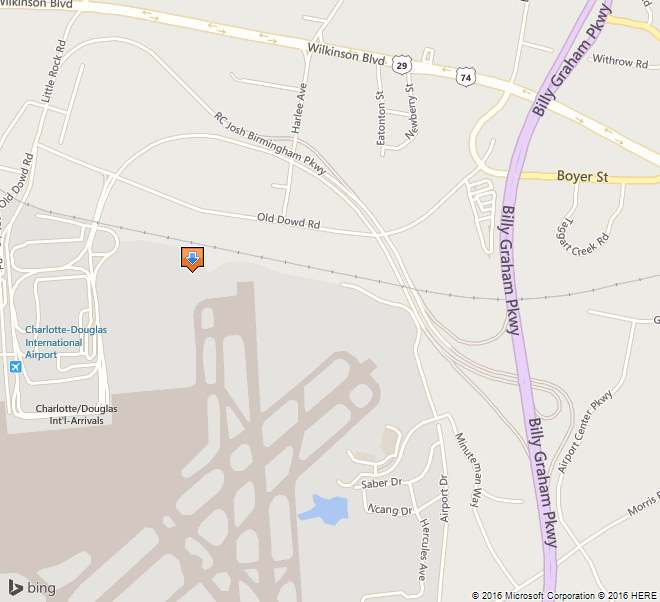
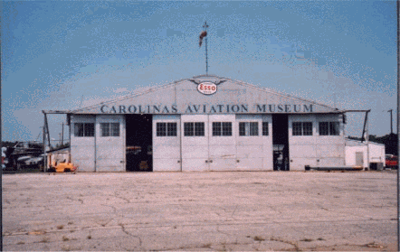
1. Name and location of the property: The property known as the W.P.A. / Douglas Airport Hangar is located at 4108 Airport Drive in Charlotte, N.C.

2. Name, address and telephone number of the present owner of the property: The owner of the property is:

City of Charlotte
600 E. 4th Street
Charlotte, NC 28202-2816

Telephone: 704-336-2241

3. Representative photographs of the property: This report contains representative photographs of the property.

4. A map depicting the location of the property: This report contains a map depicting the location of the property. The UTM coordinates are 17.506000.3905000.

wpa-map

5. Current Deed Book Reference to the property: The writer of this report was unable to find the most recent deeds to this property. The tax-parcel ID is 11522102a-005.
6. A brief historical sketch of the property: This report contains a brief historical sketch of the property prepared by Ryan L. Sumner.

7. A brief architectural description of the property: This report contains a brief physical description of the property prepared by Ryan L. Sumner.

8. Documentation of how and in what ways the property meets the criteria for designation set forth in N.C.G.S. 160A-400.5:

a. Special significance in terms of its historical, prehistorical, architectural, or cultural importance: The Commission judges that the property known as the W.P.A. / Douglas Airport Hangar does possess special significance in terms of Charlotte-Mecklenburg. The Commission bases its judgment on the following considerations:

1.) The Hangar, erected in 1936—1937 by the Works Progress Administration, was intimately tied to a federal work program that preserved Charlotteans’ skills and self-respect during a period of massive unemployment.

2.) This airport was the W.P.A.’s largest project, in allotment of funds, at the time in North Carolina.

3.) Of the original five structures built by the W.P.A. at the airport, only the hangar is extant.

4.) The establishment of the airport contributed greatly to physical and economic development of the city, ever expanding to supply comprehensive and convenient air transport to Charlotte.

b. Integrity of design, setting, workmanship, materials, feeling, and/or association: The Commission contends that the physical description by Ryan L. Sumner, which is included in this report, demonstrates that the essential form of the W.P.A. / Douglas Airport Hangar meets this criterion.

9. Ad Valorem Tax Appraisal: The Commission is aware that designation would allow the owner to apply for an automatic deferral of 50% of the Ad Valorem taxes on all or any portion of the property that becomes a “historic landmark.” The current appraised value of the 502.52 acres of land is $32,834,660. There are multiple improvements on this parcel—the current appraised value of the Hangar is $82,090, while the total improvements are valued at $147,437,660. The total current appraised value is $180,272,320. The property is zoned I-1and I-2.

10. Portion of the Property Recommended For Designation: The interior and exterior of the building and a sufficient amount of land to protect its immediate setting.

Date of Preparation of this Report: May 15, 2002

Prepared by: Ryan L. Sumner
Assistant Curator
Levine Museum of the New South
200 E 7TH St.
Charlotte, NC 28202

Telephone: 70.333.1887 x226

Historical Background Statement

Ryan L. Sumner
April 25, 2002

Summary Paragraph:

The W.P.A. / Douglas Airport Hangar (“the hangar”), erected in 1936—1937 by the Works Progress Administration, was tied to a federal work program that preserved Charlotteans’ skills and self-respect during the Great Depression. Of the original structures built by the W.P.A. at the airport, only the hangar is extant. During the Second World War, when the airport was dominated by Morris Field, the hangar serviced and stored planes for the civilian flights in and out of Charlotte. As the economy grew in the post-war years, so did the airport, which built bigger and more modern repair facilities. The hangar was leased to small chartered flight organizations until the mid-1980s when it was abandoned and fell into disrepair. The building of the airport contributed greatly to physical development of the city, expanding throughout its history to serve the air transport needs of the city.

Context and Historical Background Statement

Prior to the building of Douglas Airport, flights in and out of Charlotte were rare. The Queen City’s only airfield was Charlotte Airport (later known a Cannon airport), a small private venture operated by Johnny Crowell, a famed Charlotte aviator. Although this landing strip was christened amid much fanfare as an airmail stop on April 1, 1930,1 with passenger service from Eastern Air Transport (later Eastern Airlines) following a few months later, the field was only open on weekends, for air shows, and war-pilot training.
For Charlotte Mayor Ben E. Douglas, this inadequate air operation did not fit his vision for Charlotte, which could not grow “without water and transportation.”2 In an era when commercial flight was relatively new, Douglas continually pushed for a major municipal airport to serve the area.3 Douglas convinced prominent Charlotteans of the necessity of an airport, gradually building up a base of support. In the summer of 1935, the Chamber of Commerce appealed to the City Council to provide adequate passenger and airmail service to and from the city.4
On September 3, 1935, Mayor Douglas led the Charlotte City Council in authorizing the City Manager to file an application with the Works Progress Administration for funding to build an airport.5 The application was approved and on November 13, 1935, the council voted to divert funds in order to facilitate the purchase of land for the airport site and to repay the transfers upon the sale of airport bonds.6 The bonds were sold on March 1, 1936.7
The Works Progress Administration (W.P.A.), created by President Franklin D. Roosevelt in 1935, is considered the most important New Deal work-relief agency. The W.P.A. developed programs to create work during the massive national unemployment and economic devastation created by the Depression. From 1935 to 1943, the W.P.A. provided approximately eight million jobs at a cost of more than eleven billion dollars and funded the construction of hundreds of thousands of public buildings and facilities. By the end of 1939, 125,000 North Carolinians who were “caught between the grindstones of a maladjusted economy” had sought gainful employment from the state’s 3984 Works Progress Administration projects.8

image151
FDR visiting Charlotte, September 1936

From the National Archives and Records Administration

image152

Groundbreaking, 1935

From Charlotte / Douglas International Airport Archives

Construction began in December 1935 under the direction of N.C. W.P.A. director George Coan and John Grice, Charlotte Regional W.P.A. Director.9 Hundreds of unemployed men, bundled in overcoats, stood in line for the first W.P.A. jobs, which consisted of clearing the site of trees and underbrush. One hundred and fifty of those men found work on the airport the first day.10 Many of those present had no means of transportation and walked six or more miles to the airport site.11 The Charlotte airport project grew into the W.P.A.’s largest project, in allotted funds, until that point; W.P.A. funds accounted for $323,889.47, which were combined with an investment by the City of Charlotte $57,703.28. Of this money, $143,334.96 was paid in salary to the workers on the site.
When W.P.A. construction ceased in June 1937, the new Charlotte Municipal Airport boasted an administration/terminal building, a single hangar, beacon tower, and three runways—two 3000 feet-long landing strips and one 2,500 strip, each 150 feet wide.12 The following year, the U.S. Department of Commerce added a “Visual-type Airway Radio-beam” system and a control building, which allowed pilots to engage in blind flying and blind landing.13 Of these structures, only the Hangar remains.
The City Council wasted no time putting the new airport to use. They appointed an airport commission, chaired by William States Lee, Jr. to operate the new facility. Eastern Airlines flew the first plane into the new airport on May 17. Six daily flights took off from Charlotte Municipal Airport in its first year of operation; by 1938, the number of flights increased to eight. In 1940, the city officially dedicated the site, “Douglas Municipal,” in honor of the mayor who spearheaded the movement to built the airport.

image153
The Recently Completed Municipal Airport

Collection of the Levine Museum of the New South

image154
North Carolina Aviator, 1935
Collection of Piedmont Airlines Historical Society

Douglas Airport saw significant expansion by the federal government beginning in 1941, when the City of Charlotte leased the airport to the War Department for an indefinite period for a nominal fee.14 Between January and April of that year, the Army Air Corps oversaw the construction of Charlotte Air Base, a military installation built to the south of the Douglas Municipal site, adjoining the runways. The military acquired additional land for the project, lengthened and widened the runways; they built a huge hangar-repair facility, a hospital, reservoir, shops, barracks, and over ninety other structures.15 The air base was renamed Morris Field, shortly after the Japanese bombed Pearl Harbor. In May 1946, the War Assets Corporation conveyed the property back to the City of Charlotte, after investing more than five million dollars in the site.

image155

Female workers repair a plane at Morris Field during WWII

Carolinas Historic Aviation Commission

Contrary to what some Charlotte historians have written, commercial air travel did not cease during the Charlotte Air Base or Morris Field days. Civilian passengers continued to emplane from the municipally operated terminal with little reduction in daily flights.16 The hangar built by the W.P.A. steadfastly serviced and sheltered civilian planes throughout the war.

image156

New Terminal designed by Walter Hook, dedicated 1954

Collection of Levine Museum of the New South

In the prosperous days following World War II, the airport commission began to work on a new terminal for the epicenter of the “Sun-belt Boom.” Scheduled airline service increased rapidly from eight flights per day in 1939, to thirty flights per day in 1949.17 The new terminal, built from concrete, steel, glass and brick, epitomized the modern movement that was sweeping the country at that time. The original terminal, with its stucco walls and tin roof, didn’t fit this new paradigm; it was torn down about 1968.18
Modern hangars and repair facilities accompanied the airport expansions of the fifties and 1980s, relegating the hangar built by the W.P.A. to second-class status. The airport began to use the hangar for “fixed base operations,” and leased it to small outfits that chartered private planes for flight training and cargo transport. The hangar’s last tenant was Southeast Airmotive, which vacated the building in 1985.

image157

The Hangar while leased by Southern Airmotive, c. 1980s

From the Charlotte Observer

As a result of neglect and Hurricane Hugo, Charlotte’s last original airport building had fallen into a state of great disrepair by the early 1990s. Nearly all the windows were smashed and the doors damaged. The structure was overgrown with kudzu. The hangar was filled with several years worth of scrap and general aviation junk, while a thirty-foot mound of hurricane-related debris was piled against the outside. The Airport slated the building to be razed.19
Aviation historian Floyd Wilson met with Airport Director Jerry Orr, and convinced him to spare the building and allow it to be turned into a museum. In 1991, Wilson formed the Carolinas Historic Aviation Commission (CHAC) and held several successful fund-raisers to restore the hangar.20 Under Orr’s direction, the airport provided a security fence, replaced the broken glass, sandblasted and repainted the walls, and repaired the doors to working order.21 Today CHAC operates the facility as the Carolinas Aviation Museum, displaying a wide variety of aircraft, plus military and aviation-oriented memorabilia.
The growth of Charlotte/Douglas International Airport and the growth of the Charlotte Region are tied closely together. The airport links Charlotte with markets in the United States and around the world – an important factor in today’s global economy. According to a 1997 report by the UNC Charlotte Urban Institute, the airport contributes nearly four billion dollars in annual total economic impact to the Charlotte region, providing 71,392 jobs to workers who earn $1.968 billion in wages and salaries.22

Brief Architectural Description

Ryan L. Sumner
April 25, 2002
Location Description:
The W.P.A. / Douglas Airport Hangar is situated in the northeast corner of the Charlotte/Douglas International Airport property in southwest Mecklenburg County. The rear elevation of the structure faces northward and overlooks a steep slope down toward Airport Road and the Norfolk Southern Railroad (formerly Southern Railroad) line, which lies approximately one hundred meters behind the structure. The hangar lies one thousand meters south of Wilkinson Boulevard, the only four-lane highway in the Carolinas at the time of the airport’s construction.23 Charlotte Mayor Ben Douglas chose this site because of its proximity to the rail line, and Wilkinson Boulevard, since in 1936 pilots navigated largely by visual reference to ground landmarks.24
To the west of the hangar, the land is generally flat, grassy, and empty. None of the other structures that stood on the western side of the Hangar is extant. Immediately west of the hangar stood Charlotte Streetcar #85, which was moved to the airport following the close of the trolley line in 1938 and was converted into an office for the Air National Guard; it was removed in the 1940’s.25 Slightly farther west stood the seventy-five feet tall radio beacon tower. The airport’s administration / terminal building sat atop a now leveled slope a few yards east.
The hangar’s front visage faces south over a flat open asphalt apron (approximately twice the size of the hangar) and over the modern runways of Charlotte/ Douglas International Airport. The roar of airplanes taking off and landing in close proximity drown out conversations and fittingly dominate the space
The area east of the hangar is a continuation of the asphalted area that lies in front of the structure and is currently used as a parking lot. A non-extant runway lighting system stood on the east side of the hangar.
Structural Description:
The W.P.A. / Douglas Airport Hangar is a one story, one hundred feet wide by one hundred feet deep, by thirty feet tall, metal structure. It is typical of aviation hangars built by the Works Progress Administration (later known as the Works Projects Administration), which utilized stock plans and worked on 11 airport projects in North Carolina before 1940.26
The exterior structure has a gable roof with rounded cornices composed of prefabricated sheet metal with a pressed corrugated pattern. The exterior roof is covered with weatherproofing tar and painted silver.
The rear north-facing side of the hangar is largely composed of like materials and is punctuated by six bays of window groups. Each window group on the rear consists of a central section of fifteen panes arranged in three horizontal rows of five. On either side of each large section is a smaller group of nine panes arranged in three horizontal rows of three. The higher two-thirds of each small section are hinged at the top and can be pushed outward and propped open for ventilation. “CAROLINAS AVIATION MUSEUM” has been recently painted across the rear wall of the structure, but underneath this new sign, it is possible to read “DOUGLAS AIRPORT CHARLOTTE N.C.”
The front south-facing side is characterized by ten bays of doors that are approximately 22 feet high and ten feet across; each is punctuated with a window grouping of two sets of nine panes arranged three panes wide by three panes high. These ten doors constitute the central entrance and slide left or right along five tracks—closing the hangar completely, or creating a maximum opening of eighty feet. “CAROLINAS AVIATION MUSEUM” has recently been painted across the structure’s front above the door, and an Esso sign has been mounted near the roofline, just below a windsock mounted upon the roof.
The exterior of the hangar retains a very high level of integrity. The east and west walls have no windows and are composed of same material as the roof, but with a tighter corrugation pattern. A small addition to the west side and a larger addition to the east side were constructed sometime after the original construction. The small addition is approximately ten feet high, nine feet wide, and eighteen feet deep; it is composed of cinder blocks and wood, with a shed roof. The large addition on the west side is similarly composed of white cinder block with a shed roof, but is seventeen feet high, twenty feet wide, and one hundred twenty feet deep.
The interior of the hangar is completely open from floor to vaulted ceiling. The roof and walls are totally supported by a steel frame skeleton that consists of six I-beam tented arches, which transverse the structure from east to west. The floor is poured cement, and the interior walls are merely the reverse sides of the sheet metal used for the exterior walls.

Endnotes:

1. Charlotte Observer, (April 2, 1930), p1.; Charlotte Observer, (December 11, 1930); Blythe, LeGette and Charles Brockman, Hornet’s Nest: The Story of Charlotte and Mecklenburg County, (Charlotte, NC: Heritage Printers, 1961), p265-6

2. Carter, Gary, “Ben Douglas, Sr.: Charlotte’s Former Mayor Lives in a Future of His Own Creation,” Clippings Folder, Ben E. Douglas Papers, Robinson-Spangler Carolina Room, Public Library of Charlotte and Mecklenburg County.

3. Carter, Gary, “Ben Douglas, Sr.: Charlotte’s Former Mayor Lives in a Future of His Own Creation,” Clippings Folder, Ben E. Douglas Papers, Robinson-Spangler Carolina Room, Public Library of Charlotte and Mecklenburg County.

4. Carter, Gary, “Ben Douglas, Sr.: Charlotte’s Former Mayor Lives in a Future of His Own Creation,” Clippings Folder, Ben E. Douglas Papers, Robinson-Spangler Carolina Room, Public Library of Charlotte and Mecklenburg County.

5. Charlotte City Clerk, Minutes of the City Council (Special Meeting September 3, 1935).

6. Charlotte City Clerk, Minutes of the City Council (Nov. 13 1935).

7. Douglas, Ben E., “Ledbetter, L. L., City Treasurer to Ben E. Douglas,” (March 11, 1960), Ben E. Douglas Papers /Manuscript 109 , University of North Carolina, J. Murray Atkins Library Special Collections.

8. United States and Works Progress Administration North Carolina, North Carolina W.P.A.: Its Story (Information Service: 1940) .p1

9. Douglas Ben E., History of the Airport Scrapbooks, storage in the Robinson-SpanglerCarolina Room, Public Library of Charlotte and Mecklenburg County (labeled photographs)

10. Douglas, Ben E., History of the Airport Scrapbooks, storage in the Robinson-Spangler Carolina Room, Public Library of Charlotte and Mecklenburg County (undated unnamed newspaper clipping, circa Dec 1935)

11. Charlotte Observer (April 25, 1982)

12. Charlotte Observer (February 28, 1950)

13. Douglas Ben E., History of the Airport Scrapbooks, storage in the Robinson-Spangler Carolina Room, Public Library of Charlotte and Mecklenburg County.

14. Charlotte News (April 19, 1941).

15. Charlotte News (April 19, 1941); Charlotte Observer (February 28, 1950)

16. Charlotte City Directory (1941, 1942, 1943, 1944, 1945, 1946); Interview with Fred Wilson, President Carolinas Historic Aviation Museum (April 1, 2002)

17. Dedication Program (July 10, 1954), Douglas Airport, Clippings Folder, Robinson-Spangler Carolina Room, Public Library of Charlotte and Mecklenburg County.

18. Kratt, Mary and Mary Boyer, Remembering Charlotte: Postcards from a New South City, 1905—1950, (Chapel Hill, NC: University of North Carolina Press, 2000) p128

19. Interview with Fred Wilson, President Carolinas Historic Aviation Museum (April 1, 2002)

20. Charlotte Observer (October 21, 1992)

21. Charlotte Observer (October 21, 1992)

22. Charlotte/Douglas International Airport, Official Website. Available at: http://www.charlotteairport.com/economic.htm

23. Douglas, Ben E., “Douglas Presents History to Library,” Clippings Folder, Ben E. Douglas Papers /Manuscript 109 , University of North Carolina Charlotte, J. Murray Atkins Library Special Collections.

24. Douglas, Ben E. “‘Dad’ Douglas is on Cloud 9,” Clippings Folder, Ben E. Douglas Papers /Manuscript 109 , University of North Carolina Charlotte, J. Murray Atkins Library Special Collections.

25. Morrill, Dan L., “A Brief History of Streetcars in Charlotte,” Charlotte Mecklenburg Historic Landmarks Commission Website, available at: www.cmhpf.org/essays/streetcars.html

26. United States and Works Progress Administration North Carolina, North Carolina W.P.A.: Its Story (Information Service: 1940) p46.