Charlotte-Mecklenburg Historic Landmarks Commission

Survey & Research Reports

Stone Entry Gates (JCSU)

This report was written on September 5, 1984

1. Name and location of the property: The property known as the Stone Entry Gates of Johnson C. Smith University is located on the campus of Johnson C. Smith University, 100 Beatties Ford Rd., Charlotte, North Carolina.

2. Name, address and telephone number of the present owner of the property:
Johnson C. Smith University
100 Beatties Ford Rd.
Charlotte, N.C. 28216

Telephone: (704) 378-1000

3. Representative photographs of the property: This report contains representative photographs of the property.

4. A map depicting the location of the property: This report contains a map which depicts the location of the property.


5. Current Deed Book Reference to the property: There is no individual deed to this property listed in the Deed Books of Mecklenburg County. The Tax Parcel Number of this property is 078-201-06.

6. A brief historical sketch of the property: This report contains a brief historical sketch of the property prepared by Dr. William H. Huffman, Ph.D.

7. A brief architectural description of the property: This report contains a brief architectural description of the property prepared by Lisa A. Stamper.

8. Documentation of why and in what ways the property meets the criteria set forth in N.C.G.S. 160A-399.4:

a. Special significance in terms of its history architecture and/or cultural importance: The Commission judges that the property known as the Stone Entry Gates of Johnson C. Smith University does possess special significance in terms of Charlotte-Mecklenburg. The Commission bases its judgment on the following considerations: l) the stone entry gates symbolize the revitalization of an important black institution of higher education through the generous gift of funds by Mrs. Johnson C. Smith in 1921-22; and 2) the stone entry gates, designed by New York architect A. G. Lamont, occupy a strategically important site, at the intersection of Beatties Ford Rd. and W. Fifth St., and are a unique element in the built environment of Charlotte-Mecklenburg.b. Integrity of design, setting, workmanship, materials, feeling, and/or association: The Commission contends that the attached architectural description by Miss Lisa A. Stamper demonstrates that the Stone Entry Gates of Johnson C. Smith University meet this criterion.

9. Ad Valorem Tax Appraisal: The Commission is aware that designation would allow the owner to apply for an automatic deferral of 50% of the Ad Valorem taxes on all or any portion of the property which becomes “historic property.” The Stone Entry Gates possess no individual Ad Valorem Tax Assessment. However, the entire 44.24 acre campus has an appraised value of $575,120 for the land and $11,607,330 for the improvements, or a total appraised value of $12,182,450.

Date of Preparation of this Report: September 5, 1984

Prepared by: Dr. Dan L. Morrill, Director
Charlotte-Mecklenburg Historic Properties Commission
1225 S. Caldwell St.
Charlotte, N.C. 28203

Telephone: (704) 376-9115

Historical Overview

Dr. William H. Huffman

The stone gates guarding the old entrances to Johnson C. Smith University are fitting monuments to mark both the revitalization of that institution through the benefaction of Mrs. Johnson C. Smith and the changing of its name to honor the memory of her husband. Built in 1923 as part of a rigorous construction program funded by Mrs. Smith, the gates stand as a symbol of the commitment to the school to be one of the best black colleges in the country by Mrs. Smith, the Presbyterian church, and local leaders.

Johnson C. Smith University was started in 1867 by the Committee of Freedmen of the Presbyterian Church, USA as a school to train young black men to become teachers and preachers in the South. Through the gifts of Mrs. Mary D. Biddle of Philadelphia, the school was able to move to eight acres of land donated by William R. Myers, and in 1869, Biddle Memorial Institute opened just north of the city. It was named in honor of Mrs. Biddle’s husband, Major Henry J. Biddle, who had fallen in the recent war. Under the direction of Dr. Stephen Mattoon, (1815-1886), who began his tenure in 1870, Biddle was solidly established as one of the leading black colleges in the nation, and it also became an influential part of the City of Charlotte. The school has not only provided the education for many black professionals, but the institutions administrators and staff have played a significant role in the community and the community of Biddleville, which became connected to the city center by streetcar in 1903, grew up around it.1

Despite a disastrous fire in 1878, the school prospered. In 1912, a fine new library building was dedicated which was built from a grant by Andrew Carnegie, the philanthropist.2 Another fire of 1921 which destroyed the theologies dormitory, kitchen and dining room put the continued existence of Biddle (chartered by the state as a university in 1876) very much in doubt because of the great amount of money needed to rebuild.3 Through the Presbyterian Board of Missions, Mrs. Mary Jane Smith of Pittsburgh, PA, learned of the schools plight, and during the academic year 1921-1922 pledged about $200,000 to build a new theological dormitory, a science building, a teacher’s cottage, a dining hall, and a memorial gate to honor the memory of her late husband, Johnson C. Smith. Because of her gift, the Board of Missions of the Presbyterian Church changed the name of the institution to Johnson C. Smith University in 1922, a change which was legalized by an amendment to its state charter by the legislature on March 1, 1923.4 In all, Mrs. Smith’s gifts eventually totaled about $700,000, which built another dormitory and teacher’s cottage, a new heating plant, a printing shop, and a church, as well as added to the endowment.5

At ceremonies on the campus on October 27, 1922, which were attended by local civic and religious leaders as well as Mrs. Smith and Presbyterian officials, the dormitory, teacher’s cottage (Berry Cottage, after Mrs. Smith’s parents) and refectory (dining hall) were dedicated. As part of the proceedings, the cornerstone for the new stone science hall was laid.6 By the following year, the science building and the stone gateway were completed, and on October 25, 1923, a second dedication was held on the campus led by JCSU President B. L. McCrory, at which Harry Harding, Charlotte Schools Superintendent, Dr. James Dudley, President of the Agricultural and Technical College of Greensboro, and others spoke. The high point of the ceremonies came when Mrs. Smith was presented with an oil painting of the arched entry gate that had been painted by the professor of French at the University.7

All of the buildings and the gate arch on the campus built with Mrs. Smith’s funds (except for the church) were designed by the superintendent of architecture for the Presbyterian Board of Missions, A. G. Lamont. Lamont’s office was on Fifth Avenue in New York, and the Missions Board kept him busy designing many buildings for black colleges in the South which were funded by donors such as Mrs. Smith, although some designs were repeated in various locations. All of the structures were also built by the same Charlotte contractor, the Southeastern Construction Company. Southeastern built similar buildings for the Board of Missions from Lamont designs in Hot Springs, NC, Keysville, GA, and Cordele, GA, in 1924 as well.8

There is no question that Mrs. Smith, the Presbyterian Board of Missions, and local leaders were proud of the revitalization of the school made possible by the generous Smith gifts and that the arched gateway to the renewed campus was an appropriate landmark to symbolize its rejuvenation and the commitment of those involved to make the school a strong and viable one.


NOTES

1 Arthur A. George, 100 Years, 1867-1967: Salient Factors in the Growth and Development of Johnson C. Smith University (Charlotte: Johnson C. Smith University, 1968).

2 Charlotte Evening Chronicle, May 30, 1912, p. 1.

3 George, pp. 30-34.

4 Fifty-eighth Annual Report of the Board of Missions for Freedmen of the Presbyterian Church, Pittsburgh, PA, May, 1923, p. 40; Fifty-fourth Annual Catalogue, Johnson C. Smith University, 1921-22, p. 3 et passim; Fifty-fifth Annual Catalogue, Johnson C. Smith University, 1922-23, p. 9.

5 Inez Parker and Helen Callison, The Biddle-Johnson C. Smith University Story (Charlotte: Observer Craftsman Co., l975), pp. 19-21.

6 Charlotte Observer, Oct. 27, 1922, p. 4; Charlotte News, Oct. 28, 1922, p. 7.

7 Charlotte News Oct. 26, 1923, p. 12.

8 City of Charlotte Building Permits No. 3540, 3836, 5345, 5366, 5368, and 8454; Southeastern Construction Company files, 1924.

Architectural Description

Lisa A. Stamper

The arched stone gate near the five-point intersection of Biddleville, Charlotte’s first black suburb, marks the name change of Biddle University to Johnson C. Smith University. It also serves a more utilitarian function by designating the old entrance to the institution, and has done so since 1923. According to Dr. William Huffman, Mrs. Mary Jane Smith donated a total of $700,000 in memory of her husband, to struggling Biddle University. This money was used not only to build the stone gate, but also several buildings on the campus, with funds left over to add to the endowment. The stone gate was designed by A. G. Lamont, superintendent of architecture for the Presbyterian Board of Missions, and the contractor was the Southeastern Construction Company of Charlotte.

The stone gateway is composed of a horseshoe shaped arch over a driveway, and two flanking pillars. Sidewalks begin between each pillar and the arch, and a driveway begins underneath the arch. This rusticated gateway is made primarily of granite. The stones are cut into irregular size pieces which, except for the voussoirs, are all basically rectangular in shape. Although not apparent at first glance, the voussoirs are not all of the same length. They too are irregularly cut, with the smaller ones being near the top.

The string course of the stone gate arch is of concrete. In this case, it is not a continuous horizontal band, but allows the stone to be molded to form a polished looking, stepped outline. This outline consists or a straight, horizontal line at the very top; a step down from that are elongated S-curves which complement the round arched opening; yet another step down are short straight string courses permitting the squaring off of the sides of the structure so that they appear to be piers rather than part of an arch.

To emphasize the “piers” formed at the sides of the arch, wide pilasters with concrete string courses are located on troth sides of the stone gate. The height or these pilasters does not extend above the spring line of the arch. Another concrete string course appears to run behind the pilasters at approximately the same height as the pillars. This helps to make the pillars look more like part of the total gateway. The pillars are square and also capped with concrete string courses. A simple iron gate inside the arched opening prevents usage of the driveway.

On the side of the stone gate which faces Beatties Ford Road, a rectangular polished stone is set underneath the topmost string course. It is not surprising that this stone is engraved with the name of the university. However, there is a period placed after “Johnson”, and a comma placed after the initial “C.”

Two large trees flank the stone gateway, and several others randomly follow the driveway and sidewalks. It is difficult to determine when and/or if they were planted there, but it is obvious that many of the trees and shrubs in this area have been there for quite a while. The 1929 Sanborn map shows that the semi-circular driveway was present six years after the stone gate was built. Today the main entrance is located at the opposite end of this drive.

The stone gate has been a strong symbol of the university’s achievements since the early 1920’s. The gateway is in good condition, and students still pass through it often. This landmark deserves recognition as a monument to Charlotte’s support of Johnson C. Smith University.


Stephens House

This report was written on Apr 30, 1984

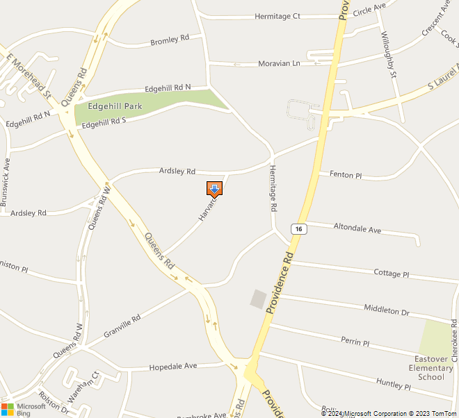
1. Name and location of the property: The property known as the George Stephens House is located at 821 Harvard Place, in Charlotte, North Carolina.

2. Name, address and telephone number of the present owner of the property: The present owner of the property is:

Mr. James P. Pressly and wife Susan T.
821 Harvard Place
Charlotte, N.C. 28207

3. Representative photographs of the property: This report contains representative photographs of the property.

4. A map depicting the location of the property: This report contains a map which depicts the location of the property.

5. Current Deed Book Reference to the property: The most recent deed to this property is listed in Mecklenburg County Deed Book 4750 at page 367. The Tax Parcel Number of the property is: 155-053-10.

6. A brief historical sketch of the property: This report contains a brief historical sketch of the property prepared by Dr. William H. Huffman.

7. A brief architectural description of the property: This report contains an architectural description of the property prepared by Miss Lisa A. Stamper.

8. Documentation of why and in what ways the property meets the criteria set forth in N.C.G.S. 160A-399.4:


a. Special significance in terms of its history, architecture, and/or cultural importance: The Commission judges that the property known as the George Stephens House does possess special significance in terms of Charlotte-Mecklenburg. The Commission bases its judgment on the following considerations: 1) the initial owner of the house, George Stephens (1873-1946), was a seminal figure in the development of Charlotte in the early 20th Century, being a co-founder of the Piedmont Realty Company, a founder of the Southern States Trust Company, later the American Trust Company, and founder and president of the Stephens Company, developers of Myers Park; 2) the probable architect of the George Stephens House was L. L. Hunter (1882-1925), who designed such important local landmarks as the F. O. Hawley House (923 Elizabeth Avenue) and the Carnegie Library on the campus of Johnson C. Smith University; 3) the George Stephens House, erected c. 1915-16, occupies a pivotal place in terms of the Myers Park townscape and is one of the older houses in the suburb; and 4) the George Stephens House is an interesting local example of a sophisticated blending of Bungalow and Colonial Revival motifs.

b. Integrity of design, setting, workmanship, materials, feeling and/or association: The Commission contends that the attached architectural description by Mr. Thomas W. Hanchett demonstrates that the George Stephens House meets this criterion.

9. Ad Valorem Tax Appraisal: The Commission is aware that designation would allow the owner to apply for an automatic deferral of 50% of the Ad Valorem taxes on all or any portion of the property which becomes “historic property.” The current appraised value of the 1.125 acres of land is $299,009. The current appraised value of the improvements is $59,242. The total current appraised value is $358,251. The property is zoned R12.

Date of Preparation of this Report: April 30, 1984

Prepared by: Dr. Dan L. Morrill, Director
Charlotte-Mecklenburg Historic Properties Commission
1225 S. Caldwell Street/Box D
Charlotte, North Carolina 28203

Telephone: 704/376-9115


Historical Overview
 

Dr. William H. Huffman
November, 1983

The interestingly varied bungalow-style frame house with a lively charm at 821 Harvard Place in Myers Park was built about 1915-16 by George Stephens (1873-1946), the energetic developer of Myers Park, and his wife, Sophie Myers Stephens (1875-1958).

Christened George Erwin Cullet Stephens as the only child of Addison and Lydia Pierson Lambeth Stephens, he was born in Guilford County, near Summerfield. After his father’s death when he was about nine years old, he and his mother moved to Greensboro, where the boy attended the school of Lina Porter (an aunt of author O. Henry). At his next school, the Oak Ridge Institute, he became interested in physical education and showed great promise as a left-handed baseball pitcher. In 1892, Stephens entered the university at Chapel Hill, and earned his way through college with an appointment as an instructor in physical education.


George Stephens
His claim to fame from his college years, however, comes from his prowess as a varsity football and baseball player. As the former, he is credited with having caught the first forward pass thrown in football in a game between UNC and Georgia in 1895, when the Carolina quarterback threw it to left halfback Stephens, who proceeded to make the only score of the game against the astonished opponents. In baseball, Stephens was called “the best pitcher Carolina ever had,” and received offers to play professionally from four of the eight National League teams of the day. John McGraw (1873-1934), the legendary New York Giants manager who led his team to ten pennants and 3 championships, called Stephens “One of the best college pitchers I have ever seen.” 1

It was not athletics that led George Stephens to Charlotte after college, however, but his college roommate and the county’s part in the good roads movement. To help earn his way through college, he had learned stenography and worked as a secretary to J. A. Holmes, the state geologist, who was making a study of good roads and road materials. This prompted Stephens to write his graduation thesis on road materials and learn in the process that Mecklenburg County was number one in good roads in the state, a fact which influenced his decision to locate here in 1896. His career was launched in Charlotte in the insurance business with his college roommate, Walter Brem, Jr., and the senior Mr. Brem. 2

It was an excellent time to be in business in Charlotte, because of the rapid growth and prosperity brought about by the booming textile industry: the city was strategically located on the main rail lines in the heart of the rapidly industrializing New South Piedmont area. That combined with George Stephens’s personality, drive and good business sense assured success, which indeed came in rapid steps. After only three years in the city, in 1899, he formed a partnership with Frederick C. Abbott, a Charlotte real estate man, and the following year the two of them organized the Piedmont Realty Company with B. D. Heath, a merchant, banker and textile manufacturer, and William Coleman. This company bought some rural acreage from Col. William R. Myers located about a mile to the northeast of the Square, and began to develop the suburb of Piedmont Park, now part of the Elizabeth neighborhood. 3

In 1901, a year after starting the real estate development, the energetic Stephens organized a new bank, the Southern States Trust Co., with his childhood friend, Word H. Wood, a Winston-Salem banker, and F. C. Abbott. Abbott began as president, Stephens as vice-president, and Wood as secretary-treasurer, but Stephens soon bought out Abbott and became president. Hardly content, the following year the Piedmont Realty built the city’s first skyscraper, the seven-story Trust Building (on the site of the present Johnston Building), which housed the bank, the growing Southern Power Co. (forerunner of Duke Power) and others. The bank’s name was changed to the American Trust Co. (1957, merged into American Commercial Bank, 1960 merged into NCNB [in 1999, the Bank of America]), and it prospered greatly during the years of rapid growth in the early twentieth century. 4


American Trust Company Building, 1924
To Charlotteans, however, George Stephens is best known as the developer of Myers Park. In 1902, after his successful career as a banker and developer was already launched, he married Sophie Converse Myers, the daughter of John Springs Myers (1847-1925). The latter had received 306 acres of prime farmland about two miles south of town from his father, Cal. William R. Myers,in 1869, to which he added over the years until his plantation grew to 1200 acres. Jack Myers had envisioned that one day his land might be used as a beautiful, park-like setting for an expanded Charlotte. 5

His dream started to become reality when son-in-law George formed the Stephens Company in 1911 with his friend Word Wood, and Arthur J. Draper, who was a textile man and descendent of the inventor of the Draper loom. Soon thereafter, William States Lee, a pioneer with J. B. Duke in the formation of what became Duke Power Company, and John M. Miller, Jr. joined the company as partners. In competition with Edward Latta’s Dilworth, which had a design laid out by nationally-known landscape architects, the Olmsted Brothers of Boston, in 1912, the Stephens Company hired John Nolen of Cambridge, Mass. to lay out a street plan and do landscape designs for some purchasers of lots. Stephens had met Nolen in 1905 when the Park and Tree Commission, which the developer helped organize, engaged Nolen to lay out Independence Park and other projects. Nolen subsequently became one of the country’s best known city planners with over 400 projects to his credit. He was joined in 1915 by a young protege, Earle Sumner Draper, who took over Nolen’s work in Myers Park and also became a nationally-known planner with his own firm (1917-1932), and later was head of planning for the TVA and acting director of the FHA. With Myers Park, these two expert planners were able to see some of the best ideas in early suburban planning carried out to an unusual degree. To entice town residents to move out to this semi-rural development, the Stephens Co. not only built the curved streets and parks according to the plan, offered the landscape services of Nolan and Draper for purchasers, and extended the streetcar lines, but also engaged in massive tree plantings and induced Queens College and the Homer Military School to locate on free land in the suburb. Stephens won the Queens College bidding in competition with three others, including Ed Latta, who wanted it in Dilworth, by offering them enough land and cash to be able to build new buildings for a campus and add to the endowment. Though it contains a wide variety of types and sizes of houses, Myers Park did attract some of the city’s wealthiest citizens, who built architecturally important homes in the area, such as the Jamison, Moody and Thies houses on Providence, and the Wade, Brown, Duke and Lambeth mansions on Hermitage. Because of its layout by Nolen (who also did the plan for Queens College) and Draper, and the execution of their plans by the Stephens Co., Myers Park also takes on regional and national significance. 7

It wasn’t until 1915 that Sophie and George Stephens got around to building their own house in the new subdivision, even though the location on Harvard Place for it, consisting of two lots, had been acquired by Mrs. Stephens in 1911 and 1912. 8 They reportedly chose a talented local architect, L. L. Hunter, to design their new home. 9 Unfortunately, not a great deal is known about Leonard LeGrand Hunter (1882-1925), who died at the relatively young age of 43. He was born near Huntersville in the county, the son of Mr. and Mrs. Robert H. Hunter, and came to Charlotte about 1905. At present, two of the city’s fine buildings are known to have been designed by Hunter, the F. O. Hawley house at 923 Elizabeth Avenue, and the Carnegie Library on the Johnson C. Smith University campus. 10 The landscaping was done by John Nolen. 11

Although the house was finished in late 1915 or early 1916 when the Stephens family (which had been living on Providence Road) could begin to enjoy their spacious new home, 12 they only lived there about three years. apparently for health reasons, the family had spent some time in Asheville, and, in 1919, they decided to make that city their permanent home. From 1912 to 1916, George Stephens and Word Wood had owned controlling, later sole, ownership in the Charlotte Observer, and in 1919, Stephens formed the Asheville Citizen Company and bought controlling interest in the newspaper of that name. In addition to development activities in Asheville and Flat Rock, Stephens remained head of the Stephens Company until 1922, when he resigned in favor of Thomas T. Allison, a longtime realtor for Mr. Stephens. Among other notable achievements in George Stephens’ busy life should be included the securing of Camp Greene army base for Charlotte in World War I, and being instrumental in the campaign to have the Blue Ridge Parkway located on the North Carolina side of the mountains. 13

When the Stephens family departed Charlotte, they sold their Myers Park home to the vice-president (later president) of the Stephens Company, Arthur J. Draper (1875-1932). 14 A Massachusetts native who was educated at Yale University (1897) and Harvard Law School (1900), Draper was a descendent of the inventor of the Draper loom, a significant advance in textile manufacturing technology. With E. A. Smith and others, he was one of the original incorporators of the Chadwick-Hoskins Co. (1907) in the city, which owned five cotton mills in the area (the Chadwick, Hoskins, Alpha, Louise and Pineville mills), and served as the president of the company for many years. Draper, who was a distant relative of landscape architect E. S. Draper mentioned above, was a major figure in the textile industry in the region and nationally. 15

In 1930, the Drapers sold the Harvard Place house to another of the early directors of the Stephens Company, William States Lee and Mary Martin Lee.16 W. S. Lee (1872-1934) was a talented and energetic electrical engineer who combined with tobacco magnate James B. Duke to develop a great system of hydroelectric power in the Piedmont Carolinas which supplied the energy for the rapid expansion of industrialization in the region. Among his many accomplishments which earned him an international reputation were his being executive vice-president and chief engineer of Duke Power Co., president and chief engineer of the Piedmont and Northern Railway (an electric train system which merged eventually with the Seaboard Coast Line in 1969), and head of his own consulting firm. 17

After Mr. Lee’s death in 1932, Mrs. Lee stayed on in the house until her own death in 1969, when the house, which stood vacant for two years afterward, passed to a son, Martin Lee. The latter opened an antique business on East Boulevard and sold many of the house’s original fixtures there, where (now occupied by the White Horse Restaurant) the stair railing from the Harvard Place residence may still be seen. 18

In 1971, the house was sold to Dr. James and Marianne Anderson, who did much restoration in their twelve years of ownership, and under the present owner, Dr. James Pressly, who bought the property in 1983, the house is undergoing extensive work. 19 Over the years, the Stephens house has apparently undergone various changes and modifications, but it has remained true to its original design. As one of the original houses in that part of Myers Park which was built by the subdivision’s developer and his wife and landscaped by John Nolen, as well as the fact that it was subsequently the home of the prominent Charlotte figures Arthur J. Draper and William States Lee, the Stephens house is unquestionably of high historical significance for the city.


NOTES

1 Charlotte Observer, Dec. 15, 1943, Sect. 2, p. 5; Asheville Citizen-Times, Nov. 10, 1940, p. 1B.

2 Charlotte Observer, cited above.

3 F. C. Abbott, “Fifty Years in Charlotte Real Estate, 1897-1947” (Charlotte: privately published, c. 1947), pp. 8-9; Record of Corporations, Book 1, p. 174.

4 Observer, cited above.

5 Thomas Hanchett, “Charlotte Neighborhood Survey,” Charlotte Mecklenburg Historic Properties Commission, 1983; II, “Myers Park,” pp. 5-6.

6 Ibid., pp. 5-30.

7 Ibid.

8 Deed Book 283, p. 234, 2 Oct 1911; Deed Book 303, p. 46, 6 Nov. 1912.

9 Interview with Kenneth Whitsett (1894-1983) by Mary Kratt, 31 August 1983.

10 Charlotte Observer, Feb. 21, 1925, p. 15; Ibid., Dec. 28, 1905, p. 4; Charlotte Evening Chronicle, Oct. 29, 1910, p. 9.

11 Interview with Marianne Anderson, Charlotte, N.C. 28 Nov. 1983.

12 Charlotte City Directories, 1915-1916.

13 Charlotte Observer, Dec. 15, 1943, Sect. 2, p. 5; Ibid.,July 2, 1922.

14 Deed Book 399, p. 385, 19 May 1919.

15 Charlotte Observer, April 27, 1932, p. (?); Record of Corporations, Book 2, p. 313.

16 Deed Book 761, p. 166, 24 Jan. 1930.

17 Charlotte News, March 25, 1934, p. (?).

18 Interview with Marianne Anderson by James Hatley, Charlotte, N.C., April, 1982; Will Roll 69-26, Frame 1327.

19 Deed Book 3289, p. 366, 24 May 1971; Ibid., 4750, p. 367, 16 Nov. 1983; interview with Mrs. Anderson 28 Nov. 1983.


Architectural Description
 

Lisa A Stamper
April 2, 1984

George Stephens, the developer of Charlotte’s prestigious Myers Park neighborhood, built his home there in 1915-1916. The George Stephens House is an unusual, innovative Colonial Revival variation on the Bungalow style, a new form of inspiration for early twentieth-century architects. One such architect was probably L.L. Hunter. According to Dr. Huffman, Hunter designed the house while John Nolen designed the landscaping.

This interesting two and one-half story home definitely looks large, and it is. However, the slate roof contains the upper story bungalow. This steep roof has a complicated shape composed of both gambrels and gables, with a variety of shed dormers, which fill all sides of the roof and add vitality. All eaves are wide and decorated with modillions. The roof is a strong design element covering at least half the total structure, and making the home a visually interesting one.

The George Stephens House is wood framed on a brick foundation. It is sheathed with wood shingles, now painted mustard yellow. Even the cheeks of its many dormers are covered with these shingles. Wooden trim, eaves, and columns are painted white. All porches have red tile and grout floors.

The plan is basically L-shaped, with side projections. The three story L-shape consists or a main block facing Harvard Place and a rear wing. The northeast projection has a first story porch topped by a second story bath. The southwest projection contains a first level kitchen area topped by second level bedrooms. A one story covered porch sits in front of this projection.

In the center of the front facade is a one-story portico. Plain columns support an equally unadorned entablature with a wide, modillioned cornice. In its upper section, the single door has many square glass panes, the top row containing pointed arched muntins. The bottom section of the door contains two simple wooden panels placed side by side. Flanking side lights are of the same style as the door, but are only one-half the size. The existing platform was removed by the present owners, Dr. and Mrs. James Pressly. It will be replaced with red tile and grout, believed to be the original materials used.

The windows are varied in size; however, all but one is rectangular. All have wooden frames. Most of the windows are double-hung, but occasionally are casement. The double-hung windows of the front (northwestern) facade main block have nine-over-nine lights, while all the others but one have six-over-six lights or less. Sometimes, rather than creating a larger window, the architect has placed two or three windows side by side. A Palladian window is located directly above the portico on the front facade. The window is very ornate, with delicate pilasters and an elegant keystone in its round arch An interesting feature of this window is that the two rectangular parts are false windows. One more window type incorporated into the house’s design is found in the northeastern porch. It is a multi-paned casement window with a small window above it containing a single row of three panes.

One-half round vents are located at the top of all the gambrel-ends except those with chimneys. A vent is also located in the gable-end of the side projection. front gable has a small rectangular casement window in its center.

A balanced design employing both symmetry and asymmetry gives the observer the feeling of informality while at the same time leaving no doubt that a person of import and wealth resides there. This is evident in the front facade. It is symmetrical at the first and second levels, but at the third story an off centered modillioned gable and twice broken roofline obscures the balance. This balance is restored by the side projections. The northeastern projection is shorter than that of the southwest; however, they both appear to be of the same design.

The northeastern gambrel-end of the main block has a smaller projecting gable roof within its gambrel. Between the gambrel end and the gable is a simple brick chimney. The gable has one dormer on its northwestern side. Supported by two simple curved wooden brackets, a balcony projects from the second story in the gable’s end. The balcony is surrounded by a decorative cast iron railing. A double door, of the same design as the window of the sunporch underneath, allows access to the balcony from inside.

The sunporch contains two columns on both outside corners and is raised a few steps above the ground. It has two sets of multi-paned double-doors; one on its northeastern side and another on its southeastern side. The screen doors on the southeast- side have rotted, but copies or those on the other side will be made to replace them.

The southwestern gambrel-end has a smaller gambrel-within-gambrel roof. An exterior chimney is located on the smaller gambrel-end. The smaller gambrel is not centered within the larger one, but shares a lower southeastern side. To the northwest or the smaller gambrel is a one-story porch, and intersecting its southeastern side is another gambrel roof.

The intersecting gambrel roofs cover a series of second floor rooms most of which are used as bedrooms. Dormers are located on all sides of the roofs. A kitchen and mud room are located on the first floor of this projection. A simple single door which enters into the mud room serves as a back entrance.

Presently, the one-story porch is enclosed with screens upon frames patterned after the windows of the porch located at the opposite side or the house. Originally, this porch was open. The two front (northeast) columns were original, and support a flat roof with wide eaves. Of course, they are decorated with modillions. This porch is also raised a few steps above ground.

The three story rear wing also has a gambrel roof, with four dormers on each side. Another chimney is located in the center of the northeast side of the wing. An open porch is partially topped by the gambrel roof and partially covered by a flat roof which runs the length or the wing’s northeast side and one-half the width or the southeast end. Instead of modillions, delicately curved brackets adorn the porches white eaves. One column shaft is located at each or the southeastern corners and three more are symmetrically placed on the northeastern side. A modified capital for each column is set within the entablature and consists of a square block with four brackets. As the others, this porch also is a few steps above the ground.

The rear wing covers most of the rear (southeast) facade. The small portion which is exposed also has various dormers in its roof. The third story has two dormers, one of which is rather small. The second story only has one dormer, but it is large enough to contain two separate windows.

The Presslys have made a few minor alterations to the exterior of the house. In the rear and the rear wing, they have put in french doors. However, these doors have been custom made to blend with the total design of the building. A set of windows previously located on the first story of the rear wing was moved to the second story, most probably keeping within the original design of the house. Also, a second story opening on the gambrel-end of the rear wing was closed.

It appears as if the interior plan has not changed significantly from the early 1900s. Some believe that additions might have been built onto the house; however, inspection or the 1929 Sanborn map shows the basic outline or the house to be almost identical to the present shape. The only difference is the Sanborn map fails to show the rear wing porch to continue around to the rear (southeast side).

As one enters the great hall from the front portico entrance, the stair is located in front, the living room to the left, and the dining room to the right. The stair begins on the first floor and goes up to the third floor. As one continues down the hall, the butler’s pantry and a half-bath is also on the right, while a storage area is to the left underneath the stairs. One may walk through this area to the living room. Another stair, located between the pantry and the kitchen in the right projection, gives access to the basement and second floor bedrooms.

The second story consists of five bedrooms, all of which have connecting baths. Only two of these rooms have to share a bath. The master bedroom has a sunroom to its rear.

It is probable that the third floor was used by the servants. One room, which might have been a bedroom, has two closets and two sets of built-in cabinets with adjustable shelves. The bath has two pedestal sinks, complete with metal cup holders. It lacks a tub, but it does have a marble shower stall with a metal framed glass door. In another room, possibly a work room, a wooden ironing board folds up into a wall cabinet, and a long storage room is connected to one side.

Throughout the years, most of the lovely mantels, fixtures, moldings, railings, etc. have been removed and sold; however, a few original remnants can be found. Many of the bathroom fixtures are original, although not always found in their original bathrooms. The cabinets in the butler’s pantry, the adjustable shelves in a second floor bedroom, and the shelves on the third floor are all intact and appear to be original. Unique, pine floors are in good condition. Their boards were cut so knots in the wood would not show.

All original mantels, except possibly one or brick in the sunporch, have been removed. One original marble mantel which looks of Tudor design is stored in the basement, and may be used in the second floor master bedroom. The mantel in the living room is believed to be a sixteenth-century Italian one. The mantel in the kitchen has been replaced by a modern stove.

The basement, surprisingly enough, is an interesting place. It stores an original mantel; original kitchen cabinets complete with metal flour bins; an elegant early kitchen stove, and a few other odds and ends. At the bottom of the stairs, the room to the left was used to store coal. Many tools used to handle the coal, as well as a good layer of coal chips, were left inside. On the outside of the door, the instructions for running the furnance, from “Combustioneer, Inc., Springfield, Ohio,” are still posted. Almost directly opposite from these instructions is a wooden plaque painted with information helpful in the operation or a hot water heater.

The surrounding site has undergone quite a few changes since 1915. The George Stephens House was originally located on land large enough for two lots. The site has since been redivided into two lots, one of which is pie shaped, faces Ardsley Road, and which has recently had a new brick home built on it.

Another change involves the John Springs Myers’ farmhouse, which used to stand behind the George Stephens House. At one point it was used as a garage and possibly housed servants as well. The 1929 Sanborn map shows the farmhouse and a separate garage, both behind the house. Neither of these structures exist today.

It is not likely that much of Nolen’s landscape design still exists, except perhaps for the brick pathways close to the house, trees, and a small garden to the northeast of the house. The drive with access on Harvard Place used to run past the southwest side of the house and then curved around to the back garage. It is now stopped by a brick wall at the end of the house. A pool and some sheds were built behind the wall and house.

The Presslys have constructed a wooden deck on the rear of the house, and plan to build a tile porch between the enclosed sunporch and the open porch. They also are in the process of erecting an antique cast iron fence around the northern corner of the building. However, they are very interested in planting shrubs, flowers, etc. which might have originally been used in the landscape design.

The George Stephens House is a stimulating variation on the Bungalow style; a style of which Charlotte has precious few examples meriting recognition. Luckily, its exterior is in good condition, and its present owners are actively interested in preserving the historic ambience of the interior, exterior, and site. This home is one of fifteen built in Myers Park in 1915, one of the best years for the suburb’s development. The architectural and historic merit of the George Stephens House is obvious. Its location in an area rich in historic significance for the city and threatened by high-density multi-family redevelopment further enforces its need for protection and recognition as an historic property.


This report was written on 28 August 1990

1. Name and location of the property: The property known as the Steele Creek Presbyterian Church and Cemetery is located at 7407 Steele Creek Road in Charlotte, North Carolina.

2. Name, address and telephone number of the present owner of the Property: The owner of the property is:

Steele Creek Presbyterian Church
RFD 2, Box 350, 7407 Steele Creek Road
Charlotte, North Carolina 28210

Telephone: (704)588-1290

Tax Parcel Number: 141-041-09

3. Representative photographs of the property: This report contains representative photographs of the property.

4. A map depicting the location of the property: This report contains maps which depict the location of the property.

5. Current Deed Book Reference to the property: The most recent deed to this property is listed in Mecklenburg County Deed Book 0003 at page 869. The Tax Parcel Number of the property is 141-041-09.

6. A brief historical sketch of the property: This report contains a brief historical sketch of the property prepared by Dr. William Huffman.

7. A brief architectural description of the property: This report contains a brief architectural description of the property prepared by Dr. Richard Mattson.

8. Documentation of why and in what ways the property meets criteria for designation set forth In N.C.G.S. 160A-400.5:


a. Special significance in terms of its history, architecture, and cultural importance: The Commission judges that the property known as the Steele Creek Presbyterian Church and Cemetery does possess special significance in terms of Charlotte-Mecklenburg. The Commission bases its judgment on the following considerations: 1) the boundaries of Steele Creek Presbyterian Church were organized by the Presbyterian Synod of New York and Philadelphia in 1764, 2) Steele Creek Presbyterian Church was one of the first seven churches established in Mecklenburg County by Scotch-Irish settlers, 3) the boundaries of the present cemetery encompass the sites of the first three meeting houses dating from the middle to late 18th century; 4) the ca. 1889 sanctuary is architecturally significant as a fine example of the Gothic Revival style; 5) the Steele Creek Presbyterian Cemetery contains basically intact headstones dating from 1763 to the present; 6) the headstones demonstrate the excellence and variety of designs carved locally in the Bigham workshop, and 7) Steele Creek Presbyterian Church is an excellent example of the role of the church in early Scotch-Irish communities.

b. Integrity of design, setting, workmanship, materials, feeling, and/or association: The Commission contends that the architectural description by Dr. Richard Mattson which is included in this report demonstrates that the Steele Creek Presbyterian Church and Cemetery meets this criterion.

9. Ad Valorem Tax Appraisal: The Commission is aware that designation would allow the owner to apply for an automatic deferral of 50% of the Ad Valorem taxes on all or any portion of the property which becomes a designated “historic landmark.” The current appraised value of the improvements is $1,337,530. The current appraised value of the 37.575 acres is $131,500. The total appraised value of the property is $1,469,030. The property is zoned R-15.

Date of Preparation of this Report: 28 August 1990

Prepared by: Dr. Dan L. Morrill in conjunction with Nora M. Black
Charlotte-Mecklenburg Historic Landmarks Commission
1225 South Caldwell Street, Box D
Charlotte, North Carolina 28203

Telephone: 704/376-9115


Architectural Description
 

Located on a spacious, approximately 40-acre, tract southwest of Charlotte, NC , Steele Creek Presbyterian Church and Cemetery represent outstanding historical, artistic, and architectural symbols of the profound Scotch-Irish influence in Mecklenburg County . The setting reflects the area’s historically rural ambience, though residential and commercial development to the south and east is graphic evidence of the county’s recent growth and of the fragility of the rural character that still remains in this section of Mecklenburg County . To the north of the church grounds is Steele Creek Nursery, and to the west stand small, early 20th-century houses scattered on large lots. These properties help to reinforce the feeling of openness that the church grounds provide.

The Steele Creek Presbyterian Church property is visually dominated by the distinguished 1889 Gothic Revival style sanctuary. Facing west, this building commands a rise of land shaded by mature oak trees overlooking Steele Creek Road (NC Hwy. 160). The winding Steele Creek Road is a historical stage route linking Salisbury, NC with Camden, SC. To the east of the sanctuary (and attached 1923 educational wing) stands a complex of three brick-veneered, two-story buildings erected between the 1950s and 1989 for classrooms, offices, a chapel, and gymnasium. Although now attached to each other, these three buildings, erected separately, are counted in this nomination as three Noncontributing structures. This complex is connected to the sanctuary by a covered walkway. A paved parking lot is located to the east of the complex of buildings and south of the sanctuary. Parking space is also located to the north and east of the church buildings, and farther east, shaded by trees, is a small playground. Neither the parking lots nor the playground interferes with the architectural integrity of the sanctuary or the artistic integrity of the cemetery, and, therefore, are not classified in this nomination as Noncontributing. Bounded by a dry-laid flagstone wall measuring about four feet high and one foot thick, the Steele Creek Presbyterian Cemetery stands northwest of the church buildings. A Contributing site in this nomination, the cemetery comprises approximately three acres and includes headstones from 1763 to the present.

Sanctuary

The handsome Gothic Revival sanctuary represents the sixth house of worship built by the Scotch-Irish congregation at Steele Creek. In 1888, the congregation’s 1858 sanctuary burned to the ground, and the following year the present one was completed on the site. The bricks were made by members of the congregation from a generous supply of clay on the grounds. The building contractor was H. J. Norris, a member of the congregation. The sanctuary’s brick walls, laid in a common bond, measured 80 feet long (six bays) and 52 feet wide (three bays). Today, the exterior of this well-executed sanctuary survives largely intact. Its Gothic Revival Style is evident in the pointed arched sash windows with textured glass in the over-lights, the pointed arched entries, and steeply pitched roof parapet. Shallow buttresses define the five bays of the main facade, as well as the six bays comprising the side elevations. Flanking the front facade, and originally signifying the sanctuary’s two main doorways, are a pair of crenelated entry towers with small copper caps and finials. A course of corbeled brick dentils accents the steeply pitched center gable, which features a circular vent surrounded by raised brick. Set directly below this vent, and above the present main entrance, are a pair of pointed-arched vented windows framed within a segmental arched brick corbeling. The major alteration to the exterior was the replacement, in 1968, of the principal pointed arched windows located between the two corner entries by a main central entrance way. At this time new paneled doors and matching paneled surrounds were added to the side entrances, and pointed arched metal roofs and fascia installed.

Attached to the east end of the sanctuary is a two-story educational wing that was completed in 1923. Four bays deep (approximately 40 feet), this addition has common-bond brick walls and granite window sills and lintels. Slate shingles cover the hip roof. The original sashes have been replaced, and the interior was modernized and partly integrated into the interior of the sanctuary in 1951.

Noncontributing Buildings

The Noncontributing resources consist of three brick-veneered buildings joined together by later infill construction. They are arranged in a row facing west, several yards to the east and south of the Contributing 1889 sanctuary and rear 1923 educational wing. Each is in good repair and serves its original function. At the north end of this complex is a Sunday School building completed in 1954. Joined to the 1923 educational wing by an arcade, it has a slate pent roof and stone-faced entrance. To the south is the church office building, representing the 1968 renovation and expansion of a community house (1926). This building, too, has a slate pent roof and is decorated with simple Gothic-inspired window and doorway treatment on the main facade. Directly to the south is the church’s new chapel and gymnasium, dedicated in 1989. The gable-front chapel is treated with restrained Post-Modern elements alluding to the Gothic.

Steele Creek Presbyterian Cemetery

Steele Creek Cemetery comprises a remarkable collection of basically intact (though sometimes moss-covered) headstones, dating from 1763 to the present. There are approximately 1,700 headstones in the cemetery to date; and about 200 date between 1763 and ca. 1820. These earliest markers were crafted by local artisans, and notably by members of the Bigham family of headstone carvers. The Bighams, who lived nearby and donated land to the church, operated their workshop in this vicinity between about 1765 and 1820 (Gatza 1988; Little-Stokes 1982; Clark 1989). While generations of Bighams cut gravestones in the vicinity of Gettysburg, Pennsylvania as well as in the Carolina Piedmont, “the best and most varied collection of their works can be found in the cemetery next to the Steele Creek Presbyterian Church. . .” (Clark 1989, 37). Among the variety of traditional designs executed by the Bighams and evident in the Steele Creek cemetery are the Scottish Thistle, the Tree of life, the Dove of Promise, rear-face decoration (11 examples identified), and family coats of arms (34 examples).

All of the gravestones in the cemetery are arranged in parallel rows running north-south, and they face east. The early stone markers are located primarily in the south half of the burial ground (south of the site of the first four churches) and were made from soapstone, granite, and marble. Those markers that post-date the work of the Bighams, and erected between the 1830s and turn of the century, often have traditionally restrained designs, with simple descriptions and flat, curvilinear, or occasionally pedimented tops. A number of them are marked with names of local and regional headstone manufacturers.

According to church tradition, the stone wall that surrounds the cemetery was constructed with slave labor during the antebellum period (Grier 1941). The wrought iron gates on the south and east entrances appear to be original, though the wall, in places, has been reconstructed and reinforced with cement mortar. In 1912, for example, stonemason Plato Price rebuilt part of the wall and may have been responsible for reconstructing the wall’s north side (Grier 1941).


Historical Overview
 

The Steele Creek Presbyterian Church and Cemetery are outstanding historical, architectural and artistic symbols of the Scotch-Irish influence in Mecklenburg County, North Carolina. Situated on a tree-shaded rise of land overlooking Steele Creek Road, the 1889 Gothic sanctuary is architecturally significant under Criterion C for its handsome expression of this style. When erected at the end of the 1880s, it was the finest, most pretentious expression of church architecture in rural Mecklenburg. (See Associated Property Type 4 – Churches and Cemeteries.) The cemetery associated with the church contains the county’s finest collection of headstones dating from late 18th and early 19th centuries, as well as a handsome, representative array of stones from the second half of the 19th century and early decades of the 20th. Bounded by a solidly built dry-laid stone wall with iron gates, this cemetery includes both traditional and popular gravestone designs reflecting the work of important local artisans – notably the Bigham family – and, subsequently, the products of larger manufacturers based not only in Charlotte, but in such cities as Columbia and Chester, South Carolina. The cemetery is therefore eligible under Criterion C. The church and cemetery are also eligible under Criterion A, because of their role in the early settlement history of the county (See Content Statement – Early Settlement). It was one of the first seven churches established in the county by the early Scotch-lrish settlers.

In 1764, a commission appointed by the Presbyterian Synod of New York and Philadelphia reorganized and adjusted the boundaries of the churches in North Carolina, and calls were sent out for pastors for Steele Creek, Providence, Hopewell, Centre (now in Iredell County), Rocky River, and Poplar Tent. Sugar Creek, to the northeast of Charlotte, already had a pastor. These were the first seven churches established in the county by the early Scotch-Irish settlers, and were sometimes known as the pre-Revolutionary “Pleiades”, or “Seven Sisters.” 1

In the first history of the church written by Rev. John Douglas (served 1866- 1879), it was thought that a church was first established in the Steele Creek area as early as 1760, but later research suggests that a church was active there as early as 1745. 2 Another former pastor, J. W. Orr (served 1912 – 1920), who wrote a historical sketch in 1915, also suggests that there was preaching at the site twenty years before the church was officially organized in 1760. 3

The early Scotch-lrish members of the congregation were farmers, whom Orr typified as “industrious, thrifty and upright…and…splendid citizens. 4 (See Early Settlement and Agriculture contexts.) Before the church was formally organized, these farmers were served by travailing preachers. Among these early “circuit riders” were Rev. Hugh McAden, Rev. Elihu Spencer, and Rev. Robert McMordie. 5 The first “settled pastor” was Rev. Robert Henry, who served both Steele Creek and Providence Churches from 1766 to 1767. In the latter year he died, and from that time until 1778, the church had neither a “settled” minister nor regular supply pastor until the Rev. James McRee took up the post and served from 1778 to 1797. Under his pastorale, the small church stabilized and gradually increased in numbers. 6 His introduction of Watt’s Psalms & Hymns, however, split the congregation and resulted in the loss of a number of members who left to form other churches in the township: Central Steele Creek (1794); Lower Steele Creek 1794) and Little Steele Creek (1800). These churches were the result of the unwillingness of several members of Steele Creek to compromise on the issue of singing hymns, not over dissension about doctrine. 7

Rev. McRee left in 1797, and the church had no regular pastor again until 1804, when the Rev. Humphrey Hunter came, who served until 1827. He was succeeded by the Rev. Samuel Lytle Watson (1828-40). 8 In the early 1800s. Steele Creek was considered large and important, even though it only had one hundred white and about twenty black members. But from the turn of the nineteenth century to 1832, the congregation was “so infected with intemperance, infidelity, Universalism and Unitarianism that strife and erratic church attendance were frequent.” But in 1832, a wave of illness, (quite possibly the influenza epidemic of that year) and emigrations seemed to steady the congregation. 9

The next major concern for the church came with the Civil War. Two hundred and four men from Steele Creek enlisted for service and one hundred and one are buried in the church cemetery. The minister during the war was Rev. Samuel Carothers Alexander (1861 – 1865), who was a native of Pennsylvania. There was continuous conflict between the minister and the congregation, such that the latter asked the Presbytery to dissolve his relationship with the church. 10

After the war, it appears that the worst struggles for the church were over. The new minister, Rev. John Douglas (1866-79), wrote the first history of the church. His successor, Rev. J. T. Plunkett (1880-82) recruited 110 new members to the fold, which helped to make up for losses due to illness and the war. The Rev. A. P. Nicholson, who served from 1882 to 1886, is remembered as an austere and upright man; he had “no patience or place for modernistic views which became popular in some places at this time.” 11

The end of the century also saw the enthusiasm with which the members of Steele Creek threw themselves into missionary and building programs. Missionary support began in the 1880s through the establishment of various church organizations: the Childrens Band of Earnest Workers (1898); the Ladies Aid Society (1880); the Young Ladies Missionary Society (1888); and the Gentlemen’s Foreign Missions Society (1896). 12

Exactly how and when the land was assembled for the church in its present configuration cannot be determined from the deed records. The first known mention of the property is in a deed dated January 7, 1771, in which William Bigham and his wife, Sarah (see Bigham family, above), sold 300 acres to a Robert Brownfield. In the description of the land, the following appears: “(Four acres of said land including the Old and New Meeting Houses the grave yard and spring on the North side of said Meetinghouses Only Excepted and Exempted in the Deed for the use of Congregation).” 13 The next recorded deed was the acquisition of an adjoining 9-3/4 acres in 1837, 14 and in 1858, they bought another adjacent 6-3/4 acres. 15 In 1883, the trustees added another 2-1/2 acres. 16 By the descriptions in the deeds, however, it is not possible to determine exactly how these parcels fit together.

The first church at Steele Creek was made of logs, “like Solomon’s temple…paved with love, but had no silver pillars or coverings of purple.” About 1780, the meeting house was enlarged into an octagonal shape. Soon after the arrival of the Rev. Humphrey Hunter as pastor, about 1804, a third church was built a few paces south of the old church. It was sixty-five feet long and forty feet wide, made of wood frame and weatherboards, hip roof, wood shingles, and eventually had a gallery put in for slaves. 17 These early churches were within the boundaries of the present cemetery.

Around 1858, the congregation put up a fourth church about 175 yards southeast of the previous one, which is the site of the present church. The fourth church burned on January 24, 1888, and four days later, the congregation determined that they would build a new church on the same site. A building committee was formed, and H. J. Norris was hired as the contractor. The fifth church was, for the first time, built of brick, which was made from clay at the bottom of a hill near the church. The new sanctuary measured fifty-three by eighty feet, had a gallery across the front, a twenty-four foot ceiling, and could seat about 1,000. The women furnished the new church with carpets, chandeliers, and indeed, everything but the pulpit, which was a gift of the twelfth pastor, Rev. W. O. Cochran (served 1887-1889). The students of Davidson College supplied a Bible, Minnie Robinson Price (Mrs. P. D. Price) provided a hymn book and the Sunday school class led by Maggie Whiteside provided a baptismal bowl and Sunday school bell. The new sanctuary was completed in March, 1889, and the dedication service took place on the following April 7th. 18

Plans for a building expansion program began in the early twentieth century. The Rev. J. W. Orr indicated in a 1915 pamphlet that there was a great need for a Sabbath School building. In that year, the push for financial support for the project began under the “every Member” plan in which every member contributed to the church on a weekly basis. 19 The result was the completion of a two-story educational building in 1923 and a community house in 1926 (which was given a brick veneer and completely renovated for offices in 1968). The sanctuary was renovated and given its present form in 1950, and in 1989, a new chapel and gymnasium were added to the south of the office building. 20

The church cemetery has some of the oldest graves in Mecklenburg County. Among them are to be found the names of many pioneering families of that part of the county: Allen, Bigham, Davis, Grier, Hart, Herron, McDowell, Neely, Porter, Sloan, Tagart, and Vance. Thirteen veterans of the Revolutionary War are buried there, and a number of families who buried members as far back as 1763 still attended in the 1970s, and thus span seven generations: Berryhill, Bigham, Cathey, Clark, Freeman, Grier, Herron, Knot, Mitchell, McDowell, Neel, Neely, Porter, Price, Sloan, Spratt, Stilwell, Whiteside and Wilson. 21 The cemetery has four sections: the eastern quarter was the original burying ground; the western quarter was used after 1840; the middle between the two was opened in 1884; and the north side was added in 1884. 22

The Steele Creek Presbyterian Church is an excellent example of the founding Presbyterian churches of the early Scotch-Irish settlers in the county and the role it played as the center of that rural community.


Notes

1 The History of Steele Creek Church 3rd Ed. (Charlotte: Steele Creek Presbyterian Church, 1978), p. 23.

2 R. E. McDowell, Historical Committee, Steele Creek Church, “Historical Summary of Steele Creek Church,” dated October 14, 1980.

3 J. W. Orr, “Historical Sketch,” 1915.

4 Ibid.

5 The History of Steele Creek Church, p. 21.

6 Ibid., pp. 2-31.

7 Ibid., p. 53.

8 Ibid., pp. 39ff

9 Ibid., p. 48.

10 Ibid., p. 62.

11 Rufus Grier. “Steele Creek Presbyterian Church: A Historical Sketch,” 1935, p. 4.

12 Ibid., p. 6.

13 Mecklenburg County Deed Book 5, p. 328.

14 Ibid,, Book 24, P 44

15 Ibid., Boot K, p. 869.

16 Ibid., Book 34, p 247.

17 History, pp. 105.

18 Ibid., pp. 7B and 14B.

19 Orr, cited above.

20 “Historical Summary,” cited above. History, pp. 149-150.

21 History, pp. 191ff.

22 Ibid., p. 203.


Bibliography

Clark, Edward W. “The Bigham Carvers of the Carolina Piedmont: Stone Images of an Emerging Sense of American identity.” In Richard E. Meyer, ed, Cemeteries and Gravemarkers: Voices of American Culture. Ann Arbor, Michigan: University of Michigan Press, 1989.

Gatza, Mary Beth. “Architectural Inventory of Rural Mecklenburg County.” 1987. On file at North Carolina Division of Archives and History, Raleigh.

Grier, Sadie. “Stones in Steele Creek Graveyard.” 1941 article in Charlotte Observer, not otherwise identified.

Grier, Rufus. “Steele Creek Presbyterian Church: A Historical Sketch ” 1935.

The History of Steele Creek Church. 3rd edition. Charlotte: Steele Creek Presbyterian Church, 1978.

Little-Stokes, Ruth, ed. “Southern Tombstones.” Newsletter of the Association for Gravestone Studies. Special issue. 6 (1982): 2-10.

McDowell, R. E. “Historical Summary of Steele Church.” October 14, 1980.

Mecklenburg County, N.C. Deed Books.

Orr, J. W. “Historical Sketch.” 1915.