Charlotte-Mecklenburg Historic Landmarks Commission

Survey & Research Reports

Shaw, Victor House

Survey and Research Report on the Victor Shaw House

  1. Name and location of the property: The property known as the Victor Shaw House is located at 2400 Mecklenburg Avenue in Charlotte, North Carolina.
  2. Name and address of the current owner(s) of the property:

The current owner of the Victor Shaw House is:

Annette Mauney Randall, Ph.D.

2400 Mecklenburg Avenue

Charlotte, NC 28205

  1. Representative photographs of the property: Click here to view representative photographs of the property.
  2. A map depicting the location of the property: This report contains a map depicting the location of the property.   The UTM coordinate for the property is: 17 518553E 3898472N


  1. Current deed book reference to the property: The most recent deed to the Victor Shaw House can be found in Mecklenburg County Deed Book 4947, page 688. The Tax Identification Number for the property is 095-05-544.
  2. A brief historical sketch of the property: This report contains a brief historical sketch of the property prepared by Lara Ramsey.
  3. A brief architectural description of the property: This report contains a brief architectural description of the property prepared by Lara Ramsey.
  4. Documentation of why and in what ways the property meets the criteria for designation set forth in N.C.G.S. 160A-400.5.
  5. Special significance in terms of its history, architecture, and/or cultural importance. The Charlotte-Mecklenburg Historic Landmarks Commission judges that the Victor Shaw House possesses special significance in terms of Charlotte-Mecklenburg. The Commission bases its judgment on the following considerations:
  6. The Victor Shaw House was the residence of Victor Shaw, who was mayor of the city of Charlotte from 1949 to 1953.  Victor Shaw and family moved into the house at 2400 Mecklenburg Avenue in 1944, just a few years before Shaw became mayor, and lived there during his two terms of office.
  7. Shaw campaigned on a platform that stressed progress and development (appropriate themes for a booming post-war Charlotte), and his administration saw the completion of Independence Boulevard, construction of a new central administration building at Morris Field and, most importantly, plans for a new municipal auditorium and civic center.
  8. Within the first year of his first term, Shaw had secured a $3 million bond to finance the Charlotte Coliseum and Ovens Auditorium.  Shaw also assembled the Coliseum Committee, which was headed by J. B. Ivey Co. Vice-President David Ovens.  With Shaw’s backing, the Committee chose a site along the newly-completed Independence Boulevard, selecting A.G. Odell Associates to design both buildings.  Although the coliseum and auditorium would not be completed until two years after he left office, Victor Shaw was able during his administration to procure the money and the plans for the complex.


  1. Integrity of design, workmanship, materials, feeling, and association.

The Commission contends that the architectural description prepared by Lara Ramsey demonstrates that the Victor Shaw House meets this criterion.

  1. Ad Valorem Tax Appraisal: The Commission is aware that designation would allow the owner to apply for an automatic deferral of 50% of the Ad Valorem taxes on all or any portion of the property that becomes a designated “historic landmark.” The current appraised value of the Victor Shaw House is $671,300.00—$318,800.00 for the building, $352,400 for the land, and $100.00 for additional features.

Date of preparation of this report:  March 8, 2004


Prepared by:  Lara Ramsey

2436 North Albany Avenue, Apt. 1

Chicago, IL 60647

Statement of Significance

Summary

The Victor Shaw House, constructed c.1928, is a property that possesses local historic significance as the home of Victor Shaw, mayor of the city of Charlotte from 1949 to 1953.  When Shaw was sworn in as mayor in early 1949, the city was undergoing a period of rapid economic and physical expansion.  Charlotte’s government had been attempting in the years after World War II to deal with the city’s ever-increasing demand for housing, infrastructure for new suburban neighborhoods, and an improved and expanded system of roads.  In his two terms as mayor, Shaw helped to continue programs begun by his predecessor, H. Herbert Baxter, that were designed to address these issues.  Shaw continued with plans to extend the newly-opened Independence Boulevard west and pushed forward with the construction of a new administration building at Morris Field.  In addition to continuing the work begun by Baxter’s administration, Shaw also developed several of his own programs, including a $10,000 beautification project for Old Settlers’ Cemetery.

By far the most important tasks undertaken during Victor Shaw’s administration was funding and planning for the Charlotte Coliseum (now Cricket Arena) and Ovens Auditorium.   Shaw had his sights on building a municipal auditorium—a project that Herbert Baxter had tried and failed to get off the ground—from the first day of his campaign for mayor.  Shaw appointed a special commission to oversee the selection of a design and site for the coliseum and auditorium, and succeeded in pushing through a $3 million bond referendum to fund the construction of the complex.  Although, due to a series of complications, the buildings were not completed until two years after Shaw had left office, his administration was credited with getting the ball rolling on the project.

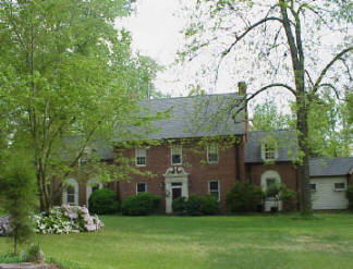
During his two terms as mayor of Charlotte, Victor Shaw and his family called the brick Colonial Revival residence at 2400 Mecklenburg Avenue home.  Located on a spacious lot in the Club Acres section of Plaza-Midwood, the house was constructed c. 1928 by Duke Power engineer James W. Knowlton.   The simple but impressive house is typical of the types of houses built for upper class Charlotteans who were just beginning to move into the neighborhood in the 1920s and 1930s.  With its sweeping, two-and-one-half-acre lot (one of the few not to be further subdivided into smaller plots), simple detailing, elaborate entrances and elegant public rooms for entertaining, the house was an ideal residence for Mayor Shaw, who owned the property from 1944 to 1954.

Historical Background Statement

Victor Shaw

The years following World War II were filled with rapid economic and physical expansion in Charlotte and other cities across the United States.   The challenges facing Charlotte’s city government in the post-war era generally revolved around the ever-increasing demand for housing, and the emergence of the automobile as the dominant form of transportation within the city and across the country. The tasks of providing the infrastructure for the expanding neighborhoods and improving and adding to the system of roads within the city were complex, and for the first time, Charlotte’s government began to address seriously how to control and direct the city’s growth.   In addition to dealing with housing and transportation problems, city officials were also pushing for a number of civic projects aimed to build Charlotte’s reputation as a modern urban center.

When Victor Shaw was inaugurated as mayor of Charlotte in April 1949, all of these issues were at the forefront of the city’s politics.  Independence Boulevard, begun under the administration of Shaw’s predecessor Herbert Baxter, was partially opened in the same month the new mayor took office.[1] The city had just completed a ten-square-mile annexation in January (the first in a line of annexations that would push the limits of the city ever outward and sharply increase its population).  The Charlotte Planning Board’s recently completed Master Plan Outline for Charlotte, North Carolina, the second master plan of the city’s history, recommended extending municipal water and sewer lines into the newly annexed area, as well as widening and extending the city’s roads and creating more parking options.  The plan also called for a series of civic projects that “aimed at enhancing the current growth” of the city, including a new administration building at Morris Field (Douglas Airport) and a civic auditorium.[2]

Victor Shaw had never held an elected office before becoming Charlotte’s mayor.  Although a relative newcomer to the city’s political arena, Shaw was no stranger to the city itself, or to its people.  A third generation Charlottean, Shaw was born January 20, 1888, in a small house on East 7th Street.   His grandfather, Robert Shaw, moved to Charlotte from New Jersey and worked as a tanner and saddler.   Robert’s son William was born in the city in 1848, and joined the Charlotte Artillery Company at the beginning of the Civil War, at the tender age of 13.[3]  In 1869, William married Mary Elizabeth Presson, and the couple had ten children, one of which was Victor Shaw.[4]


Following in the family tradition, William Shaw opened his own tannery just north of where Brookshire Boulevard rises over North Tryon Street today.  Victor grew up helping his father shape the leather for saddles and horse collars.  He attended Major Baird’s School for boys on N. College Street through the sixth grade, and received no further formal education.[5]  During World War I, Shaw served as an Air Corps lieutenant in France; by the time he returned to Charlotte, his father had switched from selling saddles for horses to selling tires for automobiles.  Victor settled into working at Shaw Tire, then located at the corner of 6th and College Streets, helping to build the company into one of the largest tire distributors in the city.[6]   In 1920, Shaw married Elsie Aileene Babbitt, a young nurse from Franklinville, N.Y. who had come to teach nursing at Presbyterian Hospital.  The couple had two children, Victor, Jr. and Elsie Babbitt.[7]


Victor Shaw was not only a native to Charlotte and a successful businessman; he was also an active citizen within the city.  Soon after he returned from World War I, Shaw became the second commander of Charlotte’s American Legion Post 9.  In 1938, he was appointed chairman of the Mecklenburg Civil Service Commission by State Supreme Court Justice William H. Bobbitt, who was resident judge of the county Superior Court at the time. Shaw held the post for two years.  Shaw was also an active member of several fraternal organizations in Charlotte.[8]

Even with his family history and business acumen, Shaw was a surprising opponent for veteran politician and three-term incumbent mayor Herbert H. Baxter.  Shaw ran on a platform of continued progress for Charlotte—in a statement made at the beginning of his campaign, Shaw claimed that “the next two years will be of paramount importance to the advancement of Charlotte and the well-being of its citizenry,” and stressed that “our forward progress must be maintained.”[9]  This platform was not markedly different from Baxter’s; yet Shaw racked up over twice the number of votes cast for Baxter in the city’s primary.  With Shaw as the only mayoral candidate on the municipal ballot, the official election was only a formality.[10]

The new mayor was an interesting character, known for his distinguished but slightly unusual manner of dress and his efficient manner of speaking. Shaw, in his early 60s during his term as mayor, struck a handsome figure, with his head of thick, wavy, white hair and immaculate suits.  Dick Young, a journalist at the Charlotte News  and a longtime friend of Shaw’s, recalled “He looked like a million dollars, always.”[11] Shaw always wore custom-tailored suits with checked vests and brightly colored bow ties.  He was also known to wear gray spats to the office every day.[12]  Although generally gregarious and quite fond of telling anecdotes, Shaw was also known for the brevity of his speeches as mayor.  His inaugural speech was, the Charlotte News noted “the shortest on record.”[13]  Dick Young recalled “He wasn’t really much of a speaker when he became mayor, but . . . it wasn’t long before he became very effective—and people remembered him because he told good stories and sat down.”[14]

As mayor, Shaw continued or expanded upon many programs that had been set forth by Baxter’s administration.  Most of these government projects were long-term and ongoing, and many would later be passed on to succeeding administrations.  In February 1950, the full length of Independence Boulevard (from Monroe Road to East Morehead Street) was opened to traffic; within weeks of the opening of this new cross-town boulevard, surveys began on possible routes for a southwest extension that would link up to Wilkinson Boulevard.[15]  The building of Independence was just the biggest and most impressive of a number of programs—large and small—designed to improve Charlotte’s system of roads.  During Shaw’s time as mayor, the city put a significant amount of money toward paving and repaving streets, putting in sidewalks, increasing parking, and widening some existing roads.[16]  Another issue at the top of the City Council’s list was extending water and sewer lines into the newly-annexed portions of the city.  Mayor Shaw also continued the development of Morris Field, a former World War Two airfield, which had been returned to the city through Baxter’s efforts.[17]  During Shaw’s tenure as mayor, construction of a new administration building for the fledgling airport was begun.

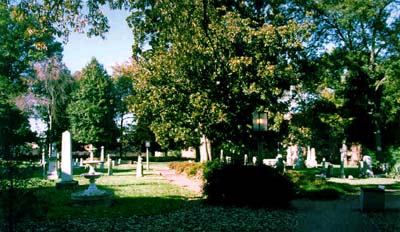
In addition to these grander schemes, Mayor Shaw also had a few smaller pet projects that he worked—with varying degrees of success—to realize. Shaw took a personal interest in the Old Settlers’ Cemetery downtown, which was beginning to show signs of neglect.  As Dr. Dan Morrill recounts in the Survey and Research Report for the property, “The first order of business was to determine ownership of the property, which was discovered to be that of the city. Mayor Shaw then persuaded the City Council to spend over $10,000 to do landscaping, lay cement walkways, install electric lights and put in a fountain. The beautification project was completed in early 1953 . . .”[18] Shaw, who had a fascination with elephants, also tried to convince the council of the pressing need for a municipal zoo.  Shaw was never able to sway the council on the idea, and the closest the mayor got to getting his elephant was the elephant’s ear that an amused citizen sent to him.  The mayor kept the ear in his office at City Hall for the rest of his term.[19]

The Charlotte Coliseum and Ovens Auditorium

By far the most important tasks undertaken by Victor Shaw during his time as mayor were the funding and planning of the Charlotte Coliseum (now Cricket Arena) and Ovens Auditorium.  In a way, this project was also a continuation of the Baxter administration.  In 1947, a proposal for a municipal auditorium and coliseum was put before the City Council, and a $2.5 million bond referendum was set for October 28th. Baxter argued that the construction of these buildings was essential for the future growth of Charlotte.  The mayor had very specific ideas about how the project should play out.  He asserted that two buildings—one for sports events, the other for cultural events—were necessary, and that a single multi-purpose structure would prove inadequate.  Baxter was also convinced that the buildings should be constructed as a complex, on a site that would provide parking and easy access.[20]  Unfortunately, Baxter had no plans or even a location to show to the citizens of Charlotte before the referendum.  There seemed to be too much uncertainty surrounding the project, and the bond issue was defeated.

Almost two years later, Victor Shaw picked up the call for a municipal auditorium and coliseum during his campaign for mayor.  In fact, the project became one of the most important issues on his platform.  An article in the April 4, 1949, edition of the Charlotte Observer listed answers of the three mayoral candidates to questions about issues ranging from rent control to slum clearance.  Shaw replied only to the questions concerning a bond referendum for a municipal auditorium.[21]  Almost immediately after his inauguration, Shaw began weighing the options for the auditorium.  Initially, Shaw—a longtime Shriner—entered into negotiations with the organization to place a 3500-seat auditorium within its Oasis Temple on South Tryon Street.  The plan was fraught with problems—the city would have to provide elevators, utilities and maintenance of the entire building, and would be forced to hand over title to the building if they failed to do so.  When the story broke in September 1949, many Charlotteans were justifiably upset, and Shaw quickly abandoned the plan.[22]

Shaw switched tactics, asking the City Council to appoint a special commission to select an appropriate location, as well as the architect and designs for the buildings.  Shaw appointed David Ovens, Vice-President and General manager of J. B. Ivey Co. and President of the Charlotte Community Concert Association, to head the committee. The group went to work searching for an appropriate location and designer for the complex.  In May 1950, the committee selected A.G. Odell and Associates to design the two buildings.[23]  With mayor Shaw’s support, the committee finally found an ideal parcel with 1000 feet of frontage along the newly-constructed Independence Boulevard.  The lot was large enough for both buildings, with room left over for parking.  Its position along the eastern end of Independence also assured that traffic congestion would not be a problem.[24]

With both an architect and a location, the City Council set a $3 million bond referendum (approximately $2.5 million of which would go toward building the coliseum and auditorium) for October 14th.  This time the bond issue passed; and the council moved forward, purchasing the parcel on Independence and appointing a Coliseum Authority to oversee the construction and (eventual) running of the facilities.[25]  Unfortunately, the project soon encountered several snags, including several delays in construction due to steel shortages and a subsequent federal ban on amusement buildings.  By the time these restrictions were lifted, the City Council discovered that estimates for the project far exceeded the amount of money available from the first bond referendum.  By the time a second bond for $1 million was proposed for June 1953, Victor Shaw had left office.[26]  Construction began soon after the second bond passed, and the complex opened to the public in 1955.

Although the Charlotte Coliseum and Ovens Auditorium were completed a full two years after Victor Shaw’s term as mayor ended, plans for the complex solidified under his administration.  The $3 million bond passed during Shaw’s first term ensured that the project would eventually be realized.  The selection of a site along Independence Boulevard, on the outskirts of the city, helped to draw business and people out of the center city along the new cross-town road, and the designs developed by A.G. Odell would help to put Charlotte on the map as a truly modern city.  The planning of the coliseum and auditorium established Victor Shaw as a progressive leader of post-war Charlotte.

The Victor Shaw House

During his two terms as mayor, Victor Shaw and his family called the two-story Georgian Revival house at 2400 Mecklenburg Avenue home.  The house stands in the Club Acres section of Plaza-Midwood, near the Charlotte Country Club.  Organized by a group of prominent Charlotte businessmen in 1910, the country club was the city’s first golf course.  Hoping to capitalize on the new club, F. M. Laxton (one of the shareholders in the country club), developer Paul Chatham, banker Word Wood, and Duke Executive W. S. Lee formed the Mecklenburg Realty Company and began laying out Club acres, a new subdivision just to the west of the golf course.[27]  Mecklenburg, Matheson, and Belvedere Avenues were quickly platted within the subdivision, but buyers were few and far between.  The reasons for Club Acres’s glacial development were shared by the other subdivisions that made up Plaza-Midwood—the neighborhood was far from downtown; it was further hemmed in by the Seaboard Air Line Railroad, which ran at grade along Central Avenue and caused frequent delays for commuters; and its small trolley line was separate from the Southern Public Utilities Company line that ran downtown, requiring passengers to transfer between the two lines in order to get to and from the center city.[28]

In order to attract buyers, the Mecklenburg Realty Company was forced in 1919 to rescind the original deed restriction for the subdivision that stipulated lots were to be no smaller than one acre—developers in other Plaza-Midwood subdivisions used similar measure to help sell lots.[29]

With the arrival of the automobile, the problems of distance and trolley lines that had plagued Club Acres and the rest of Plaza-Midwood in their early years became largely irrelevant.  During the 1920s and 30s, the neighborhood began to attract members of the upper class, who could afford the latest form of transportation.  As historian Thomas Hanchett observes in his history of Plaza-Midwood,

In the late 1920s and 1930s Mecklenburg and Belvedere avenues belatedly began to attract members of the city’s leadership circle. Among them were cotton processor A. L. Boyle who built a Colonial Revival house designed by William Peeps at 2415 Mecklenburg (1928), Carolina Trust Company vice-president Benjamin J. Smith at 2448 Mecklenburg (1928), lawyer Robert E. Wellons at 2300 Mecklenburg (1932), WBT radio program director Charles Crutchfield at 2331 Mecklenburg (1943), and real estate leader William Tate at 2826 Belvedere (1939).[30]

The Victor Shaw House was constructed on lot #26, located at the intersection of Matheson and Mecklenburg Avenues and one of the original parcels offered by Mecklenburg Realty Company.  George Stephens, an early developer of Myers Park, and his wife Sophie, originally owned the lot.  In 1928, the lot was sold to James W. Knowlton, a Duke Power engineer, and his wife Marie Wheeler.[31]  The Knowltons were quite familiar with the neighborhood—the family had been living just down the street at 2320 Mecklenburg Avenue.  Their modest frame house had been built in 1918, and was among the first houses in the subdivision.[32]  According to a long-time resident of Club Acres, Knowlton hired the J.A. Jones Construction Company to build the two-story, brick, Colonial Revival residence.[33]

Victor Shaw purchased the house from James Knowlton in August  1944.[34]  The stately residence, set back far from the street on its sprawling lot, was an ideal home for Shaw, his wife, and their two children.  The family stayed in the home through Shaw’s two mayoral terms, and sold the house to real estate attorney Robert A. Wellons and his wife in 1954, one year after Shaw left office. The house had three subsequent owners before being sold to its current owner, Annette Mauney Randall (and her husband John Dainotto) in early 1985.[35]

Physical Description

Site Description

The Victor Shaw House is located at 2400 Mecklenburg Avenue in the Plaza-Midwood Neighborhood of Charlotte.  The house sits on a 2.588-acre lot on the south side of Mecklenburg Avenue, facing north onto the street.  Set approximately in the middle of the lot, the house is reached by a gravel drive that runs along the western side of the property, curving around to the rear double garage.  The parcel is relatively flat, with a slight downward slope running southwest along the east edge of the back yard.  A small fishpond is located in the backyard, on the eastern edge of the property near the house.  The pond dates back to the construction of the house.

Architectural Description  

Colonial Revival residences abound in Plaza-Midwood and other Charlotte neighborhoods—the style was popular across the United States in the late nineteenth and early twentieth centuries—and the Victor Shaw house is a typical example of the kinds of Colonial Revival houses built in the 1920s and 30s.  The house consists of a side-gable main building flanked by two smaller, side-gable wings.  The main section of the house is two stories tall and approximately three bays wide.  The one-story wing on the west side of this center section is approximately one bay wide, while the corresponding east wing is one-and-one-half stories tall and approximately two bays wide. These east and west sections are roughly one bay deep, and the center section of the house is approximately two bays deep.  The resulting footprint for the entire structure is narrow and irregular.  To the west of the house sits a one-and-one-half story garage. The front-gable structure is clad in the same brick used on the house, and is joined to it by a one-story connector sheathed in siding.  Two paneled garage doors take up most of the south wall of the garage; a small apartment occupies the attic space above.

The exterior walls and some load-bearing interior walls of the house are constructed of 17” structural clay tiles.  These tiles, while commonly used in early twentieth century commercial construction, are rarely found in Charlotte’s residences.  The exterior of the house is clad in red face brick laid in common bond, with a simple soldier stringcourse running along the north and south elevations of the main section and east wing of the house. Grey slate tiles cover the roof of the house and the garage.  A corbelled brick chimney rises from the east gable of the main section of the house, matched by a false chimney on the west gable to give an appearance of symmetry.  On the façade (north elevation) of the main section of the house, a simple cornice ornamented with a row of dentils runs underneath the roofline.

Windows in a variety of shapes and sizes regularly punctuate the exterior elevations of the house.  The majority are six-over-six, double hung windows covered with exterior storms.  Most of these windows are unadorned, with only simple brick soldier-courses serving as decorative lintels.  On the main house, the windows are regularly and symmetrically placed along the first and second floors of the north and south elevations; the windows on the first floor of the east and west wings are surrounded with large, rounded arches. The walls between the arch and the window are covered with stucco.  These rounded arch surrounds are an unusual feature, and one not seen on most Colonial Revival designs.  The first floor window on the north elevation of the garage and the large second-floor window on the south elevation of the main house are more conventional examples of rounded arch windows.  The attic levels on the east and west elevations of the main house are marked with quarter-circle windows on each side of the chimneys, and half-circle, louvered windows are located under the gables of the east and west wings.  Gabled dormer windows pierce the roofline on the north and south elevations of the west wing, the north elevation of the east wing, and the center bay of the center section’s south elevation.

Large, elaborately ornamented entrances dominate both the north (façade) and south elevations of the main house.  Each entrance is centered along the first floor of the elevation.  The entrance on the façade is slightly more ornate, with its swan’s neck pediment and rounded finial.  Small wood pendants accent the dentiled cornice just below the pediment.  Two fluted pilasters flank the doorway, rising to simply molded columns.  The paneled wood door is protected by a simple screen door, and topped with a leaded glass transom.  Two glass lanterns sit on either side of the entrance.  The south elevation entrance features a fan light with radiating panes set under a basket weave arch.  The doorway is centered underneath the fanlight, and has the same paneled wood door seen on the façade entrance.  Flanking the doorway are sidelights, each with four glass panes.

Both the north and south entrances open into the main stair hall of the house.  The half-turn staircase dominated the narrow room, with the first run of the stair hugging the east wall.  The curtail step at the base of the staircase supports the curved newel post.  Below the simple wood handrail, twisted wrought iron balusters alternate with smooth iron rails marked with a center diamond. A chair rail located approximately three feet from floor runs along the walls of the room, and wide dentil moldings mark the meeting of walls and ceiling.  A small arched doorway located at the north end of the west wall of the stair hall leads through a short hall and into a small, unadorned breakfast room.  Passing through a doorway on the west wall of the breakfast room, one enters into the kitchen.  Located in the small west wing of the house, the kitchen features a secondary staircase that runs behind the north wall of the room.  A simple wood door separates the stairwell from the kitchen. A doorway on the south wall of the breakfast room leads into the dining room, which can also be reached through a wide entrance located at the south end of the stair hall’s west wall.  The room features the same chair rail and dentil molding seen in the hall.  Wide oak boards cover the floor of the dining room.

To the east of the stair hall is the large parlor, which stretches from the front (north) to back (south) wall of the main house.  Again, the oak flooring, dentil molding, and chair rail are present in the room, and simple rectangular panels outlined with simple molding mark the walls above the chair rail.  One of the two fireplaces in the house is centered along the east wall of the room; a wood mantel, simply decorated with low-relief festoons and urns, surrounds the firebox.  At the north end of this same wall, a doorway leads into a small study, which takes up the east wing of the house.  The second fireplace is located in the southwest corner of this room.

The second run of the main staircase leads to the second floor of the house.  A carpeted center hallway runs east to west along center of this floor, with a series of bedrooms leading off from the hall.  The east end of the floor, which takes up the upper story of the east wing, houses the master bedroom and bathroom.  A second bedroom and bathroom are located on the north side of the hall, in the center of the main house.  Another bedroom is across the hall, on the south side of the house.  The door to the kitchen staircase is located at the west end of the hall, along its north wall.  The hallway terminates at the west side of the house with a small room located in the attic of the east wing.  These rooms generally lack the elaborate detailing seen in the public rooms on the first floor of the house.

Another flight of stairs leads up to the expansive attic space of the main portion of the house.  A wood door pierced by fifteen rectangular glass panes leads into the unfinished attic space.  From this space, one can see the structural clay tiles that make up the exterior walls of the house.

The Shaw House has changed only slightly since its construction in the early 1920s.  The most substantial alteration to the house occurred in 1960, when Joseph Wright (its third owner) added onto the rear of the east wing in order to extend the study (referred to as a “den” in the building permit) and make room for the master bathroom.[36]  A one-story, screened in porch was also added to the back of the east wing. A set of sliding glass doors was installed along the south wall of the master bedroom to provide access to the flat roof of the porch.  Despite these changes, the Victor Shaw House has retained its architectural integrity, and appears much as it did over 80 years ago.

[1] Dr. Dan Morrill,  “The Road that Split Charlotte,” Parade,  2 May 1982, p. 19.


[2] Sherry Joines Wyatt and Sarah Woodard, Final Report: Post World War II Survey, http://www.cmhpf.org/postww2survey.htm.


[3] Dr. Annette Randall,  “A Brief Family History of Victor Bryson Shaw (b. January 20, 1888/d. August 11, 1966), Mayor of Charlotte, 1949-1953,”  (unpublished paper), 1.


[4] Ibid.


[5] “Colorful Victor Shaw, Ex-Mayor, Dies at 77,” Charlotte Observer, 12 August 1966.


[6] Ibid.


[7] Ibid.


[8] “Ex-Mayor Shaw Dies Here at 78,” Charlotte News,  12 August 1966 (no page number—given to author by Dr. Annette Randall).


[9] Ibid.


[10] Legette Blythe, “Shaw Wins Mayor’s Race,” Charlotte Observer, 26 April 1949, section 1 page 1.


[11] Charlotte News, 12 August 1966.


[12] Ibid.


[13] Dick Young, “New Administration Takes Helm at City Hall,” Charlotte News, 9 May 1949 (no page number—given to author by Dr. Annette Randall).


[14] Charlotte News, 12 August 1966.


[15] “Independence Boulevard Now Officially Opened,” Charlotte Observer, 2 February 1950, Section2/Page 1.


[16] Hal Tribble, “City to Rush $3 Million Bond Election Plans,” Charlotte Observer, 25 May 1950, Section 2/Page 1.


[17] “City Officials Work to Speed $500,000 Job,” Charlotte Observer, 4 February 1950, Section 2/Page 1.


[18] Dr. Dan L. Morrill,  “Survey and Research Report on Old Settlers’ Cemetery,” prepared 3 January 1984, http://www.cmhpf.org/S&RR/settlers.html.


[19]Charlotte Observer, 12 August 1966.


[20] Paula M. Stathakis, “The Ovens Auditorium and Charlotte Coliseum (Original):  Historical Essay,”  (part of the Survey and Research Report on Ovens Auditorium and Charlotte Coliseum, prepared 30 July 1990), www.cmhpf.org/surveys&rcoliseum.htm.


[21] “Candidates Give Mayoral Views,” Charlotte Observer, 9 April 1949, Section 2/Page 1.


[22] Stathakis.


[23] Hal Tribble, “Contract will be Submitted to Governing Heads Today,” Charlotte Observer 12 May 1950 (no page number—taken from clipping file at Special Collections, J. Murray Atkins Library).


[24] Stathakis.


[25] Ibid.


[26] Ibid.


[27] Thomas W. Hanchett, “Plaza-Midwood,”  http://www.cmhpf.org/educationneighhistplazamidwood.htm.


[28] Ibid.


[29] Ibid.


[30] Ibid


[31] Mecklenburg County Deed Book 687, Page 186.


[32] Hanchett


[33] Notes by Dr. Annette Randall on conversations with H. G. Glasgow.


[34] Mecklenburg County Deed Book 1129, Page 177.


[35] Mecklenburg County Deed Book 4947, Page 688.


[36] Charlotte Building Permit for 2400 Mecklenburg Avenue, 17 August 1960.


 davidsonmill

SURVEY AND RESEARCH REPORT

ON

The Davidson Cotton Mill 

  1. Name and location of the property: The property known as the Davidson Cotton Mill is located 209 Delburg Street, Davidson, North Carolina.
  2. Names and addresses of the present owners of the property:

Davidson Cotton Mill LLC

PO Box 2270

Davidson, NC 28036


Duke Power Company

Tax Department PB05B

422 South Church Street

Charlotte, NC 28242-0001


  1. Representative photographs of the property: This report contains representative photographs of the property.
  2. Maps depicting the location of the property: This report contains a map depicting the location of the property.
  3. UTM coordinate: 17 513713E 3928945N
  4. Current deed book and tax parcel information for the property:

The Tax Parcel Number for the Davidson Cotton Mill Milling Building  is 00326108.  The most recent reference to this property is recorded in Mecklenburg Deed Book 08463 – 650.

The Tax Parcel Number for the  Transformer House associated with the Davidson Cotton Mill is 00326219.  The most recent reference to this property is recorded in Mecklenburg Deed Book 02248-305.

  1. A brief historical sketch of the property: This report contains a brief historical sketch of the property.
  2. A brief architectural description of the property: This report contains a brief architectural description of the property.
  3. Documentation of why and in what ways the property meets criteria for designation set forth in N. C. G. S. 160A-400.5:
  4. Special significance in terms of its history, architecture, and/or cultural importance: The Commission judges that the property known as the Davidson Cotton Mill does possess special significance in terms of Charlotte-Mecklenburg. The Commission bases its judgment on the following considerations:

1)      The Delburg Cotton Mill, the forerunner to the Davidson Cotton Mill, represented a new era of industrial development in Davidson that occurred concurrently with similar development within Mecklenburg County as a whole.

2)      The Delburg Cotton Mill formed part of the newly-diversified economic base in turn of the 19th-20th century Mecklenburg County. The new diversified economy rested on agriculture, manufacturing and processing, marketing and distribution, and banking; pillars that accelerated the growth that made Mecklenburg County the booming financial center of the Carolina Piedmont.

3)      The Delburg Cotton Mill and the the Davidson Cotton Mill, like other industrial and manufacturing endeavors in Davidson, encouraged rural to urban migration, increasing the town’s population and offered an alternative to cash crop farming in the area

4)      The Davidson Cotton Mill Milling Building is among the best preserved cotton mill buildings in Mecklenburg County, and is significant as a well-preserved example of the mill buildings associated with the small towns in Mecklenburg County.

6)    The Southern Power Company Transformer House appears to be one of the few surviving examples of an early 20th century power transmission buildings in Mecklenburg County.

5)      The Davidson Cotton Mill Milling Building demonstrates the innovations in terms of architecture, power, and transportation that evolved in cotton mill design in first half of the 20th century.

  1. Integrity of design, setting, workmanship, materials, feeling and/or association: The Commission contends that the physical and architectural description which is included in this report demonstrates that the Davidson Cotton Mill Milling Building meets this criterion.
  2. Ad Valorem tax appraisal: The Commission is aware that designation would allow the owner to apply for an automatic deferral of 50% of the Ad Valorem taxes on all or any portion of the property which becomes a designated “historic landmark.”

The Milling Building: The current total appraised value of the improvements is $3,682,300. The current appraised value of the lot is $405,100. The current total value is $4,087,400

The Transformer House:  The current total appraised value of the improvements is $11,000. The current appraised value of the lot is $17,100. The current total value is $28,100.

Date of preparation of this report: February, 2004

Prepared by: Stewart Gray and Dr. Paula M. Stathakis  

Historical Overview

Contextual Statement: The Development of the Cotton Manufacturing Industry in Mecklenburg County.

In the ante-bellum period, Mecklenburg County possessed a variety of underdeveloped natural resources that ultimately formed the building blocks for the county’s economic maturity. Cotton agriculture, infrastructure improvement through railroads and bridges, inexpensive labor, and proximity to the waterpower of the Catawba River laid the foundation that supported the county’s transition into the economic hub of the Carolina Piedmont. However, the potential of these resources were not fully realized until the late nineteenth century. Historians of Mecklenburg County agree that that its location in the Piedmont region was a principal aspect in its transformation from a small hinterland courthouse town to the primary industrial center of the region.[1]

Cotton processing and manufacturing concerns were rare in the county in the ante-bellum period. Industrial development was largely hindered by a lack of capital and subscribers, and was overridden by the region’s focus on agriculture. Only a few textile mills existed in the area before the Civil War. The first textile mill built in Mecklenburg in 1848 by William Henry Neel along the Catawba. The Rock Island Manufacturing Company was also organized in 1848, but both mills closed before the Civil War.[2]

In 1856, geologist Ebenezer Emmons recommended that entrepreneurs and industrialists consider the section of the main trunk of Catawba River between the Tuckasegee Ford and the great Horse-Shoe bend for the great potential of water power. At this location, a high island divides the river. The fall at Mountain Island was twenty-two feet, “sufficient to secure the most important advantages to such manufacturing establishments as its favorable position may demand.” Emmons recommended improvements such as locks and dams up river from the Horse-Shoe bend to enlarge the possibilities for river trade and water power for manufacturing sites located along this stretch of the water.[3]

In spite of this endorsement, industry was slow to develop in Mecklenburg County and in the Piedmont region as a whole, because the wealthy were not inclined to invest it in manufacturing; they preferred to put it in agriculture and export trade.[4] In the decades after the Civil War, economic recovery was slow and painful, and it was not until the 1880s that local investors and entrepreneurs began to capitalize on the county’s natural attributes and resources.

This change in the county’s economic fortune occurred slowly; and even at the height of its manufacturing output, the county remained largely agricultural and rural in character. Although Charlotte made significant advances in the post-Civil War period, it did not develop to the extent as much as other southern cities. In 1870 there were no major manufacturing concerns in Charlotte even though two major railroad lines converged in the city.[5] In a general report about the state’s economic prospects, Vice-Consul H.E. Heide wrote, “The majority of the cotton and woolen manufacturing manufacturies are situated in the central portion of the State, where numerous rivers and water courses furnish almost unlimited water power. Nearly all the industries of the state are in a very backward condition owing to the want of capital to develop its great natural resources. The greater part of the available capital the State possessed was lost in the late civil war.”[6]

This economic languor would soon give way in the wake of an outpouring of entrepreneurial and manufacturing initiatives that were based in agriculture, the primary pillar of the county’s economic base. Cotton was the core from which most of Charlotte’s new economic enterprises of the late nineteenth century developed. Cotton would be stored, marketed, and processed in and around Charlotte.  Textile engineering and machinery firms with legions of blue and white-collar workers would find jobs in Charlotte. Railroads transported cotton products out of the area; and some of the profits from all of these activities would be seen in the development of the downtown area, of new streetcar suburbs, in the increase of the retail and service sectors, and in the growth of new industrial zones on the margins of the city.

By the late nineteenth century, Mecklenburg farmers, like most Piedmont farmers, devoted a substantial part of their crop to cotton — a marked shift in agricultural patterns from the ante-bellum period during which most small farmers practiced subsistence agriculture. By 1896, over one-half of the cotton produced in North Carolina was grown in 28 counties, and most of it was grown in and around Mecklenburg.[7] In addition to the proximity of a healthy cotton crop, Charlotte began to develop the other essential components that would support the new economic reality that was apparent by the late 1870s. Railroad lines destroyed during the war were restored; and two new lines were added to the network that served the county by 1873, making six operational lines by mid-decade.[8] By this time Charlotte already had five banks, making it a regional financial center.[9] By the early 1880s, Charlotte mayor Col. William Johnston introduced a program to pave, or macadamize city streets. Concurrent with this program, county agencies began a similar plan to improve county highways. New taxes paid for most of these programs, and convict labor was used for the construction.[10]

Thanks in part to improvements in agriculture, banking, and infrastructure, Charlotte began to assemble its manufacturing base. By 1873, the city had 36 manufacturing establishments, and the number of these increased to 66 as early as 1877. However, city leaders lamented that in spite of this progress, Charlotte still had no textile mill. In an attempt to encourage the addition of textile mills to the city’s industrial landscape the Board of Aldermen passed an order in 1873 stating any cotton or woolen mill built in Charlotte would be tax exempt.[11] The Aldermen got their wish in 1880 when R.M. and D.W. Oates established the Charlotte Cotton Mills. In contrast to the earlier cotton mills in Mecklenburg, Charlotte Cotton Mills was a subtantial factory with 6240 spindles. The Daily Charlotte Observer hailed it as a “new departure” from the factory style usually seen in Charlotte and predicted that it would not only contribute to the city’s fortunes, but that it was a harbinger of things to come.[12]

By the early 1880s, industrial growth in Charlotte became more assertive, and this expansion was inspired and directed largely by entrepreneurs who were not Charlotte natives, but who became synonymous with Charlotte in its new identity as a New South City. The new movers and shakers in town were educated entrepreneurs who understood how to capture Charlotte’s potential, and more importantly, how to finance it.

Notable among this new breed of civic leaders were Edward Dilworth Latta and Daniel Augustus Tompkins. Both Latta and Tompkins redirected Charlotte’s disorganized enthusiasm for change, growth, and progress. They understood the necessity of breaking the region’s reliance on farming, especially on an agricultural system that operated largely through crop liens and tenancy. Instead they emphasized industrialization, urbanization, and scientific agriculture as the viable alternatives of a prosperous future.[13]

Tompkins opened a branch of the Westinghouse Machine Company of Pittsburgh in Charlotte in 1883, and by 1884 opened the D.A. Tompkins Company, a premier manufacturer of textile machinery, and a principal supplier of textile equipment to southern textile mills.[14]Tompkins wore many hats in Charlotte; he was an engineer and a businessman; he owned three newspapers; and he wrote extensively on the topic of cotton, cotton processing, the construction and management of textile mills, and how to raise the capital to build new factories. In his how-to manual for aspiring mill investors, Tompkins contended that the “average Southern town underestimates its ability to raise capital to build a cotton factory. Cotton mill property like all other property is cumulative. No town could raise the money at once to pay for all the property in it. When the author first went into business in Charlotte, N.C., in 1884 there was but little cotton manufacturing in the South, and in Charlotte but one mill. The author at once formulated a plan for enabling small towns to raise capital for manufacturing.” [15]

By the early twentieth century Mecklenburg County had grown in prominence as a major marketing, manufacturing, and distribution center of regional significance. In 1924, the number of spindles in Mecklenburg cotton mills ranked third behind Gaston and Cabarrus Counties.[16] Mecklenburg County entered the twentieth century with a much stronger and more diversified economic base than it had in 1870, and clearly change had come rapidly and perhaps dramatically to the region. Certainly by the turn of the century one sees fewer complaints of war related impoverishment and more interest in the hustle of the new pace of life that was first evident in town by the 1890s. The hum of the mills became part of the rhythm of life in Charlotte and in the smaller surrounding towns and villages of Davidson, Cornelius, and Pineville. Mecklenburg never had as many mills as some neighboring counties, such as Gaston and Cabarrus, but the cotton and textile industry were an essential component of the county’s and the city’s economy.

Cotton Manufacture in the town of Davidson and the Delburg/Davidson Cotton Mill.

The small town of Davidson, a rural hamlet and home to Davidson College (established 1837), was incorporated on February 11, 1879 under the name of Davidson College.  In 1891, the town shortened its name to Davidson. Davidson is situated in the northern part of Mecklenburg County and at the turn of the twentieth century was separated from Charlotte by 22 miles of railroad track or by 20 miles of county road. The gulf between the two towns was filled with farms and long stretches of empty road.[17]

Like much of the rest of Mecklenburg, the town economy of Davidson was initially based on agriculture and shop keeping. Davidson College also supplied a number of professional and service jobs for the town. In the late nineteenth century, the small town branched into industrial production with the establishment of the Linden Cotton Factory in 1890 (later operating under the name of the Linden Manufacturing Company and the Carolina Asbestos Company). [18]

The success of the Linden Mill was an inspiration. During this period in the South, the construction of any industrial or manufacturing complex was a visible and tangible sign of progress. Townspeople typically responded to the addition of such buildings to the landscape with approval. According to the Davidson College Magazine, local businessmen were pleased with the prospects of this mill and were immediately anxious to build another.[19] Within a year, the magazine reported happily in an article titled “Our Village is on a Boom” that the new cotton mill had been built by the depot, and had necessitated widening the streets. The subsequent opportunities for employment meant that there was not a vacant house to be found in the town.[20] This enthusiasm was reaffirmed in the next month’s issue, in which the magazine asserted in an article titled “Our Cotton Mills are Still Booming” that the town had 2008 spindles and more on the way.[21] By 1893, the magazine reported that the Linden Mills were working to capacity and that a new cotton gin would be built on Concord Avenue.[22]

The town’s desire for industrial expansion was satisfied, although slowly. The Southern Cotton Seed Oil Company opened its doors in 1899.[23] By 1900, Davidson could boast of a handful of manufacturing and processing businesses. The Linden Manufacturing Company was in full operation with 7000 spindles and 70 employees. In addition to the Southern Cotton Oil Mill, the Davidson Milling Company (a flour mill) formed part of the town’s new economic landscape.[24] 

Two thousand bales of cotton were sold at Davidson annually in the first years of the twentieth century.[25] As the Linden Mill operated successfully, investors soon organized to build another mill. The Delburg Cotton Mill Company filed a Certificate of Incorporation on July 8, 1907. The mill was organized to buy and sell cotton, wool, and other raw materials and to manufacture these into yarns for clothing and other fabrics. The corporation was also authorized to develop water, steam, and other types of power and to develop pole lines for the transmission of electric power and to utilize and sell power. The capital stock of the corporation was $100,000.00 and was divided into 1000 shares. The corporation could organize and begin business when $11,000.00 of shares had been subscribed. This was accounted for by the sale of 55 shares to J.P. Munroe, 50 shares to W.R. Greg, and 5 shares to A.B. Young. The corporation was limited to 30 years.[26]

The Davidson College Magazine anticipated the completion of the new cotton mill (the Delburg, later known as the Davidson Cotton Mill), which was under construction near the depot at the intersection of Delburg and Watson Streets and would open its doors in January 1908.[27] The Charlotte Daily Observer noted in January 1908 that the mill was still under construction and when completed the mill would be a modern facility with the most up-to-date equipment, using electric power, automatic fire extinguishers and water hydrants outside the mill. The mill also had a 140,000-gallon water tank that it would share with the Linden Mill.[28] The mill was initially serviced entirely by rail, and early Sanborn Maps show no roads leading to the mill. Loading docks were oriented toward the rail lines.

In the previous month, the magazine had published an article titled “Cotton Mills and the South.” This article weighed the merits of the recent spate of industrial development in Davidson and in the region as a whole and questioned the long-term value of increased emphasis on cotton manufacturing. “We feel the Southland is awakening from her long sleep…” and that two dangers lurked in the midst of progress. The first is that too many mills were being built too quickly, or faster than the acreage of cotton, or the “demand for cotton goods will justify.” Secondly, the promises inherent in rapid industrialization would result in a flight from the fields to the mills, making “…farms deprived of hands and at the same time the children who would grow up in the country are brought to the cotton mill to the almost utter destruction of theirs hopes for the future.”[29] 

In Davidson, as in mill communities across the South, the Linden and the Delburg filled with many workers seeking a change from the hardscrabble farm life. The majority of small farmers in the region were hostage to the whim of global cotton market prices and were tethered to the land by the cycle of debts they owed to local merchants, bankers, and factors. Many farm laborers left the fields for the factories in hopes that regular hours and cash wages would improve their standard of living. Life in any mill was always hard. Hours were as long as work on the farm. Mills were hot in the summer and cold in the winter; the air was always full of lint; and the din of machinery was incessant. Unlike farm labor, which varied according to the season, the pace and pattern of mill labor was monotonous and the mill hand’s day was governed by the clock and the whistle. Although mill workers were usually paid in cash and mill companies often provided housing, a laborer’s wages rarely covered the bare necessities of living expenses.                                     

Mill life proved to be as difficult as farm life, but mill workers formed communities that were the source of their religious and cultural worlds as well as their working world. Mill hands lived in company housing and often had their own gardens in the summer. Some kept cows, hogs, and chickens. Baseball was a major summer pastime for mill workers, and they met for games on Saturday afternoons at a ball field near the present Sadler Square. Many were loyal Davidson College sports fans.[30] 

The Delburg Mill expanded with the construction of an addition in 1914.[31] An amendment filed in 1920 shows that the Board of Directors adopted a resolution on June 10, 1920, to increase the authorized capital to $1,000,000.00 to be divided into 10,000 shares worth $100.00 each. The thirty-year limit to the corporation was changed to an unlimited period.[32] Sanborn Fire Insurance Maps show the mill had doubled in size by at least two additions by 1925.  

By 1923, the Linden Mill and the Delburg Mill merged, creating the Delburg- Linden Company. As of 1923, the capital stock of the company was $240,000.00, and the company operated as the spinners of high-grade knitting and tire fabric yarns.[33]  In July 1923, J.P. Munroe, president of Delburg-Linden Mills, sent a letter to the stockholders informing them he was negotiating with Martin Cannon with reference to selling him the mill. Munroe did not think that he would be able to sell the mill for what the property was worth, but he believed that it was worth it to sell the mill at any price owing to “…conditions in the mill business are such with labor conditions uncertain, money commanding high rates of interest, cotton constantly fluctuating in price, yarn buyers comparatively scarce and hard to please, that considering all these things, I myself am willing and anxious to sell at some price even though that price be considerably below par.”[34]

The post World War I economic boom of the 1920s was deceptive. In the years immediately following the war, the transition to a peacetime economy resulted in a chaotic period during which soaring inflation undermined the stability of the early twenties. By 1922, the general economy appeared to be in recovery if not in an unprecedented boom. However, looming beneath the surface of the prosperity of the Roaring Twenties were several “sick industries” among them, agriculture and textiles. These so-called sick industries never recovered during the boom years of the 1920s and were harbingers of the Depression years before the economic catastrophe occurred.

Stockholders of the Delburg –Linden Mill were notified of a special meeting to be held on August 23, 1923 to determine if the company should be sold to Martin Cannon.  The arrangement was for Cannon to purchase the mill for $242,500.00 of which $42,000.00 to be paid in cash and the remainder in preferred stock of the prospective corporation. Cannon and associates would pay $100,000.00 into the prospective corporation.[35]

After Cannon purchased the mill, the name was changed to The Davidson Cotton Mill. The mill’s officers were Martin L. Cannon; president, J.F. Connor; vice-president, E. Sanvam; secretary; J.G. Barnhardt; buyer, and D.W. McLemore; superintendent.  The old Linden Mill facility was closed and used as a cotton warehouse. Davidson Cotton Mill was incorporated in 1923 and by 1924 had 14,688 spindles and 39 cards, and capitalized stock of $325,000.00.[36]

The Davidson Cotton Mill struggled through the Great Depression and into the 1940s. A letter from the company secretary and treasurer, C.W. Byrd, to former Davidson College professor Dr. Henry Louis Smith illustrates a measure of the mill’s problems. Dr. Smith, a stockholder, had written to the mill inquiring when dividends would be paid. Byrd answered that in 1936, the company had a deficit of $125,000.00 and according to North Carolina law; no dividends could be paid until the deficit was wiped out. By 1941, the company had a surplus of $26,753.00, but did not anticipate paying dividends because of projected heavy taxes.[37]

The mill enjoyed a run of post World War II prosperity and was owned by some local businessmen including a Mr. Potts.  But the mill closed in 1950. The building lay idle until Bridgeport Fabrics, a Connecticut company, purchased it around 1954. Bridgeport Fabrics operated in the old milling building until around 1962 and produced webbing and zipper backing. When Bridgeport Fabrics closed operations in the old milling building, the company began producing other products in a new facility that incorporated parts of the cotton mill’s warehouse/dye house across the Delburg Street.[38]

The mill building was quiet for many years, serving mostly as a warehouse. Davidson College purchased the property in the 1970s and used it for storage.[39] In 1996, an investment group, Davidson Cotton Mill, LLC purchased the property. The milling building has been renovated for high-end shops, offices, and restaurants. A condominium complex has been built adjacent to the project.[40]


Architectural Description

The Davidson Cotton Mill consists of several brick industrial buildings located on Delburg Street north of the historic center of the Town of Davidson.  The mill is located between Watson Street and the Norfolk Southern Railroad line that runs north-and-south through the town from Charlotte to Statesville. The mill began as the Delburg Mill, and was built in 1907 adjacent to the rail line.   The site slopes away from the rail line to the south and the west.  A neighborhood of frame houses associated with the mill is located along Watson and Delburg Streets to the north and west of the mill.  

The Delburg Mill was originally composed of two principal buildings.  The larger of the buildings was the proper mill, and to the north was a smaller warehouse building. The milling building is generally intact and has been incorporated into the larger mill building associated with the Davidson Cotton Mill.  The one-story masonry mill building is tall despite having a very low-pitched roof, and its brickwork is laid in American Bond with five rows of stretchers for each row of headers.   The building is six bays wide and was originally twenty-two bays deep.  The gabled façade is symmetrical and consists of six large segmental-arch windows.  The milling building was divided into two sections with a shallow “picker house” room at the front of the building, and a large open floor in the rear that contained the machinery for winding, reeling, and carding.  The picker house and the rest of the building are separated by a brick firewall that projects in steps above the roof.  On the north elevation extensive corbelling was required to extend the firewall past the eaves.  The original entrances to the mill are located in the first and fourth bays of the north elevation.  The entrance in the first bay opened into the picker house, and the second entrance opened into the milling area.  Both entrances are distinguished by round-arch openings with decorative corbelling.  The roof is supported by large timber rafters, set about six feet apart, with rounded ends that extended past the exterior walls to support the eaves.  Two rows of chamfered wood posts run the length of the building, supporting the roof framing.  This heavy type of timber framing came to be known as “slow burn” construction.  During a fire massive timber framing tended to char but retain much of its strength, whereas iron framing would more easily fail in a hot building fire. Slow burn construction was promoted by the New England Mutual Fire Insurance Companies and was popularized in North Carolina by the influential mill builder and designer D.A. Tompkins.  Timber purlins connect the rafters and support beaded plank roof decking.  In the front picker house, purlins project past the façade to support the front eave.  A small room is attached to the center of the buildings south façade that may have contained toilets. 

 North Elevation Detail Original Entrances on the North Elevation


 Corbelled Firewall

Access between the picker house and the rest of the building is limited to a single doorway originally equipped with iron doors on a tilted tracks, designed to seal-off either section of the building in case of a fire.  One of these doors remains in place.  It appears that the interior walls were coated with stucco.

A small brick wing extends from the milling building’s south elevation, setback one bay from the façade.  The wing housed a machine shop, and at one time an office. Because of the sloping topography of the site, a basement room could be constructed under the office housing the heating plant. A firewall separates the machine shop from the rest of the wing, and again the firewall forms a parapet that extends past the eaves on the wing’s east and west elevations.  Unlike earlier mills, the Delburg Mill was designed as an electric powered mill, and required a relative small boiler for heating.  The furnace chimney (demolished) was located on the wing’s west elevation.  A wooden platform (demolished) extended from the Machine Shop to the railroad tracks.

The cotton warehouse to the north of the milling building has been greatly modified.  A 1915 Sanborn Map Company map shows a simple rectangular building with a small “opener room” attached to the building’s east elevation.  A single parapet wall on the west side of the present building may be the only vestige of the original building.  A smaller cotton waste building  (demolished) was located to the south of the milling building.

Cotton Warehouse (Altered)

To the north of the warehouse sits the only other original building from the era of the Delburg Mill, a two-story power transformer building.  The 1915 Sanborn Map lists the building as the “Southern Power Company Transformer House.”   This tower-like Romanesque Revival Style building features two tall segmental arched openings on the south elevation, with three smaller round-arched window opening perched above and highlighted with corbelled brick work.  The east elevation faces the railroad tracks and is pierced with three low segmental arched openings, a doorway centered between two windows, at ground level, and five round vents near the eave.  The building is sheltered by a hipped roof, topped with a metal ventilator. 

Transformer House

The Delburg Mill was expanded greatly between 1907 and 1924, when it was sold and renamed the Davison Cotton Mill.  The first addition appears to have been an extension of the milling floor with the construction of eight additional bays extending from the mill’s west elevation.  The construction and materials of this first addition appear to be nearly identical to those used for the original building.  Again, large timber rafters extend past the brick walls, which are regularly pierced by segmental-arch window openings.  But whereas the original mill building was constructed over a crawlspace, the sloping topography of the site allowed for a full basement level under the first addition.   The only variance from the original design of the mill building was the addition of a large monitor roof to both the addition and the original building.  The four-foot tall twelve-light windows of the monitor were mechanically operated and probably did much to illuminate the interior of the mill and ventilate the space.  The lack of furring strips along the top of the rafters in the addition, and their presence on the rafters in the original section, would indicate that the monitor roof was installed when the addition was added. 

North Elevation Detail of Different Window Opening Types

A second larger expansion, probably completed before 1924, added another eighteen bays to the west elevation of the milling building.  A full basement level was constructed under this addition, nearly doubling the size of the mill.  The basic construction method of thick solid masonry walls laid in American Bond continued, and again the same large-timber roof system was employed.  However, gone were the segmental-arched window openings, replaced by openings that ended at the roof deck on the side elevation, and flat-topped openings that relied on metal lintels in the west elevation and the basement level. It is likely that the windows from the original building and the first addition were replaced during the second expansion.  The windowsills on the older sections of the building appear to have been raised to the level of the newer windows.  Steel framed twenty-four light windows with operable vent-sections may have replaced the original wooden double or triple hung windows.  In contrast to the low-gabled east elevation, the new six-bay-wide west elevation is a full two stories with a step-parapet wall.  More toilets and an elevator shaft protrude as a tower from the south elevation of the new section.  By 1925 a conveyer belt connecting the picker house to the cotton warehouse had been added.  Change had also occurred around the machine shop.  The earlier chimney had been demolished on the west elevation, and a new chimney (since demolished) had been constructed on the east elevation.  A large flue, perhaps for a forge, was also added.  The office by this time had been moved to its own building, since destroyed, north of the mill building.  A second warehouse (demolished after 1996) was erected to the south of the milling building.  The new warehouse was of frame construction, covered with metal siding, and topped with a hipped roof.

Detail of South Elevation
West Elevation

Sanborn maps indicate that by 1925 a loading dock was located on the west elevation.  This would have indicated a change in the nature of transportation associated with the mill.   While the original Delburg Mill may have depended solely on the railroad for the transportation of manufactured goods, it is likely that by 1925 some of the product of the mill was being carried by trucks.

While the milling building underwent modifications throughout the 20th century, by 1925 the building had generally been developed into its present form.  Change, however, did continue at the Davidson Cotton Mill with a radical alteration of the cotton warehouse  between 1925 and 1937.  The warehouse was expanded to the north, and was divided to create a “dye house” that shared the space.  The office building shown on 1925 Sanborn Maps had been demolished and replaced by a new frame construction office building to the west of the original site.[41]  The only change to the milling building itself was the addition of a now-demolished one-story shed addition to the south elevation adjacent to the elevator and toilets.  Sometime after 1937 a low shed-roofed brick addition was added to the south elevation of the machine shop wing. 

By the 1950’s the complex was no longer operating as a cotton mill.  Around 1954 Bridgeport Fabric began using the milling building to produce webbing and the fabric backing used in zippers.  At this time the lower section of the milling building was used for shipping, receiving, and as a warehouse.  All materials and products entered and left the building through the loading dock on Watson Street via trucks.  Production of these materials ended around 1962.  Bridgeport Fabrics continued other operations across Delburg Street at a new facility that incorporated parts of the old cotton warehouse/dye house.[42]  The only extant early 20thcentury features of the cotton warehouse/dye house are parapeted fire walls that rise out of the sprawling mix of later additions.  

The milling building was used as a warehouse until 1996 when the building was purchased and the process of rehabilitation began.  The machine shop wing, the picker house, and part of the main floor were converted to a restaurant.  During this process the deteriorated floor of the picker house was replaced with concrete.  The remainder of the milling building was converted to offices on the main and basement levels.  Office partitions have been built in such a way that the timber frame of the building is exposed and highlighted.  The floors in the rest of the mill building were also in a deteriorated state and have been skimmed with a light-weight concrete.  At the time the building was purchased in 1996, all of the windows had been covered in plywood.  The metal-framed windows installed sometime before 1925 were removed and replaced with insulated divided-light windows that replicated the configuration of the lights in the ca. 1925 windows.  No original exterior doors survived.  Before the renovation several industrial door openings had been cut into the brickwork.  One of these openings was glazed and used as an entrance to the restaurant area.  Other openings were restored back to the original fenestration.  A mid-20th century loading dock on the south elevation adjacent to the machine shop has been replaced with stairs; and a wheelchair ramp, and an exterior stair tower has been attached to the building’s south elevation between the elevator tower and the southwest corner of the building.

Architectural Significance

The milling building associated with the Davidson Cotton Mill is significant as one of the best preserved early-20th century cotton mill buildings in the small towns of Mecklenburg County.  The only other cotton mill in Davidson is the Linden Cotton Mill, which has been significantly altered.  Other mills, such as the Chadwick-Hoskins Mill No. 5 in Pineville, have been so altered that they can no longer be easily interpreted as an early 20th century cotton mills, while other mills such as the Cornelius Cotton Mill have been altogether lost.  The Anchor Mill in Huntersville is perhaps equally significant in terms of the development of the county’s small towns; however at this time the Anchor mill is in a deteriorated state.

As the Delburg Mill, the mill was among the earliest in the county to be designed as an electric powered mill.   Highland Park #3, built in Charlotte a few years earlier, was touted to be the first in the area to be designed to be powered by electricity and not coal fired steam.  While retaining much of the historic material associated with its early incarnation as the Delburg Mill, the milling building demonstrates the development and expansion of cotton milling in the first half of the 20th century.   The Davidson Cotton Mill also demonstrates the evolution of industrial transportation in this county.  Built specifically in 1907 to be service by the rail lines, the factory had by 1925 been modified to accommodate the new mode of industrial transportation, trucking. 


[1] See, for example, Thomas W. Hanchett, Charlotte’s Textile Heritage, available on line atwww.cmhpf.org/educationhanchetttextile.htm; Hanchett, Sorting Out the New South City, (Chapel Hill: University of North Carolina Press, 1998; Dan L. Morrill, Cotton Mills in New South Charlotte, available on line at www.cmhpf.org/educationtextilehistory.htm; Morrill, A History of Charlotte and Mecklenburg County, available on line at www.danandmary.com.

[2] Hanchett, Charlotte’s Textile Hertiage.

[3] Ebenezer Emmons, Geological Report for the Midland Counties of North Carolina. North Carolina Geological Survey, (New York: George P. Putnam and Co., Raleigh: Henry D. Turner, 1856), pp. 7-9. North Carolina Collection, available on line at www.docsouth.unc.edu

[4] Hanchett, Charlotte’s Textile Heritage.

[5] Carolyn F. Hoffman, The Development of Town and Country: Charlotte and Mecklenburg County, North Carolina, 1850-1880, (Ph.D. Dissertation, University of Maryland, 1988), p. 201.

[6] R.E. Heide, Report of Vice-Consul Heide,on the Resources, Trade and Commerce of North Carolina, (Wilmington, N.C., 1875), pp. 9-10. North Carolina Collection.

[7] North Carolina Board of Agriculture, North Carolina and Its Resources, (Winston: M.I. and J.C. Stewart, Public Printers and Binders, 1896), p. 158. North Carolina Collection.

[8] Morrill, A History of Charlotte and Mecklenburg, Chapter 7.

[9] Hanchett, Sorting Out the New South City, p. 24.

[10] Daniel Augustus Tompkins, Cotton Mill. Commercial Features. A Text-book for the Use of Textile Schools and Investors. With Tables Showing Cost of Machinery and Equipments for Mills Making Cotton Yarns and Plain Cotton Cloths, (Charlotte, N.C. Published by the Author, 18990, p. 144

[11] Hoffman, The Development of Town and Country, pp. 202-203. According to Dan Morrill, A Survey of Cotton Mills in Charlotte and Mecklenburg County, July 1997. www.cmhpf.org/essays/cottonmills.html,  cotton mills were built in the county in the Steel Creek township in the 1850s, and in the Providence township in 1874; the first textile mill in Charlotte was not built until 1880-81.

[12] Morrill, Survey of Cotton Mills, p, 2.

[13] Ibid.

[14] Ibid., p. 3.

[15] Tompkins advocated selling shares in an installment plan, a scheme that he had worked out in his days as a machinist at the Bethlehem Iron Works in Bethlehem, Pennsylvania. He published this plan in several manufacturers’ periodicals, such as the Manufacturers’ Record, and was able to demonstrate that several southern cotton mills were established through this system.

[16] Edgar Thompson, Agricultural Mecklenburg and Industrial Charlotte. Social And Economic. (Charlotte: Queen City Press, 1926), p. 137.

[17] Daniel Augustus Tompkins, A History of Mecklenburg County and the City of Charlotte. From 1740-1903, vol. II, (Charlotte: Observer Printing House, 1903), p. 195.

[18] Mary Beaty, Davidson: A History of the Town from 1835-1937. Contracting part of the words Iredell and Mecklenburg created the name Delburg.

[19] Davidson College Magazine, March 1890, vol. V no. 7, p. 41.

[20] Ibid., October 1891, vol. VII, no. 1, p. 28.

[21] Ibid., November 1891, vol. VII, no. 2, p. 61.

[22] Ibid., October 1893, vol. IX no. 1, p. 33.

[23] Beaty, Davidson.

[24] Tompkins, A History of Mecklenburg , p. 196.

[25] Ibid.

[26] Mecklenburg County Courthouse, Record of Corporations Book 2 Page 256.

[27] Davidson College Magazine, December 1907, p. 202.

[28] Charlotte Daily Observer, January 13, 1908.

[29] Ibid., November 1907, pp. 113-114.

[30] Bill Brannon, Mecklenburg Gazette, “The Way It Was,” nd.

[31] Thompson, Agricultural Mecklenburg, p. 144.

[32] Record of Corporations Book 6 Page 187.

[33] Special Collections, Davidson College Library, Folder: Linden Manufacturing Company, Davidson N.C.

[34] Ibid., Letter, July 31, 1923 from president J.P.Munroe to stockholders.

[35] Ibid., Notice of Special Meeting of Stockholders of the Delburg-Linden Company, August 23, 1923.

[36] Thompson, Agricultural Mecklenburg, p. 144.

[37] Special Collections, Davidson College Library, Folder: Davidson Cotton Mills, 1933-1943. Letter from C.W. Byrd to Dr. Henry Louis Smith, October 21, 1941.

[38] Interview, Stewart Gray with former mill employees John Fisher and Ruben McIntosh, February, 2004.

[39] Amy Ledbetter, Mecklenburg Gazette, “Mill to Get a Facelift,” February 19, 1997.

[40] Doug Smith, Charlotte Observer, “Historic Davidson Cotton Mill to be Offices, Shops, Condos,” March 2, 1996, p. 2D.

[41] Interview with John Fisher who worked at the mill  in the 1950’s, 2-29-04.

[42] Interview with Rubin McIntosh who worked at the mill in the late 1950’s, 2-29-04.


Settlers’ Cemetery (Old)

This report was written on January 3, 1984

1. Name and location of the property: The property known as the Old Settlers’ Cemetery is located on West Fifth Street, between Poplar and Church Streets, in Charlotte, North Carolina.

2. Name, address, and telephone number of the present owner and occupant of the property: The present owners of the property are:

City of Charlotte
600 East Trade Street
Charlotte, N.C. 28202

Telephone: (704) 374-2241

3. Representative photographs of the property: This report contains representative photographs of the property.

4. A map depicting the location of the property: which depicts the location of the property. This report contains a map depicting the location of the property.

5. Current Deed Book Reference to the property: The Register of Deeds office contains no individual Deed to this property. The Tax Parcel Number is 078-012-01.

6. A brief historical sketch of the property: This report contains a brief historical sketch of the property prepared by Dr. William H. Huffman.

7. A brief architectural description of the property: This report contains an architectural description of the property prepared by Thomas W. Hanchett.

8. Documentation of why and in what ways the property meets the criteria set forth in N.C.G.S. 160A-399.4:


a. Special significance in terms of its history, architecture, and/or cultural importance: The Commission judges that the property known as the Old Settlers’ Cemetery does possess special significance in terms of Charlotte-Mecklenburg. The Commission bases its judgment on the following considerations: 1) the Old Settlers’ Cemetery was the first municipal burial ground in Charlotte, North Carolina and functioned in this capacity from 1776 until 1867, 2) the Old Settlers’ Cemetery contains the earthly remains of many of the most prominent citizens of Charlotte and Mecklenburg County in the late 18th and 19th century, and 3) the Old Settlers’ Cemetery forms the centerpiece of the Fourth Ward Historic District.

b. Integrity of design, setting, workmanship, materials, feeling and/or association: The Commission contends that the attached architectural description by Thomas W. Hanchett demonstrates that the Old Settlers’ Cemetery meets this criterion.

9. Ad Valorem Tax Appraisal: The Commission is aware that designation would allow the owner to apply for an automatic deferral of 50% of the Ad Valorem taxes on all or any portion of the property which becomes “historic property.” The subject property is owned by the City of Charlotte and is therefore, exempt from Ad Valorem Taxes.

Date of preparation of this report: January 3, 1984

Prepared by: Dr. Dan L. Morrill, Director
Charlotte-Mecklenburg Historic Properties Commission
1225 S. Caldwell Street
Charlotte, North Carolina 28203

Telephone: (704) 376-9115


Historical Overview
 

Dr. William H. Huffman

Sitting on part of the hilltop that comprises the heart of Charlotte, just two short blocks from the Square, is the city’s oldest cemetery. Now as much a pleasant inner-city park as a cemetery, it shares the block bounded by 5th, Poplar, 6th and Church Streets with a modern condominium building and the old North Carolina Medical College. Since it is just to the East across 5th Street and from the venerable First Presbyterian Church, it has been assumed by many to be, or to have been, a cemetery connected with the church. Indeed, one of its old popular names was “The Presbyterian Burying Ground,” but, as it turns out, this was never the case, even though it was a reasonable assumption.

The history of the church and the cemetery were intimately linked, however, in the early days of the Queen City. The town itself was established in 1768, the year following the purchase of 360 acres of land from George Augustus Selwyn (1719-1791) for that purpose by the town commissioners. Selwyn had inherited a 100,000-acre tract in 1751 from his father, Colonel John Selwyn, Esquire, an English country gentleman who had been granted the parcel from George II in 1745 for services rendered to the crown. In the 1760s, the younger Selwyn, through agents in North Carolina, began to sell off tracts, mostly plantations of 200 to 500 acres along the creeks and rivers.

Apparently the present sites of the First Presbyterian Church and the cemetery were both used for religious worship and burials, respectively, not too long after the formation of the town. It was not until 1815, however, that those two locations were officially set aside exclusively for their traditional purposes by the city. The Town Church, as it was originally known, was constructed from 1818 to 1823, and was intended for use by all denominations, but because of their greater numbers, was used mostly by the Presbyterians. Similarly, the cemetery was the only nondenominational one in town, but would have naturally contained more Presbyterians than others. Thus the name, “The Presbyterian Burying Ground,” was not totally inaccurate, even though it was not an official church cemetery. In 1835, the First Presbyterian Church did acquire the Trade Street site for its exclusive use, but this did not include the old cemetery.

The oldest known burial in the Old Cemetery is that of Joel Baldwin, who died October 21, 1776, at the age of 26, and, although the site was closed in 1867, burials with special permission took place until 1884. During that time, many of Charlotte’s families, from the best-known to the least, were laid to rest there, including veterans of the Revolutionary and Civil Wars. A good number of them were the founding pioneers of Charlotte and Mecklenburg County. The northwest corner of the cemetery was set aside for the servants of the families whose members were interred there.

One of the figures from the Revolutionary era there is Colonel Thomas Polk, who died in 1793, and was the great-uncle of President James K. Polk. Among his accomplishments were reported to be his holding office as one of the county’s first commissioners, being treasurer and trustee of Queens College and a member of the Colonial Assembly, and signing the Mecklenburg Declaration of Independence. Next to him is his wife, Susannah Spratt Polk, whose father’s house, that of Thomas Spratt, was the site of the first court held in Mecklenburg County.

A hero of the Revolutionary War, Major General George Graham (1758-1826) is also interred in the Old Settlers’ Cemetery. Graham came to Charlotte in 1764 from Pennsylvania, and was at the historic battle at McIntire’s farm where a small group of patriots sent a detachment of 600 British soldiers back to Cornwallis with the complaint that there was a “rebel behind every bush.”

Another interesting figure from the early era to be found in the hilltop graveyard is Dr. Nathaniel Alexander (1756-1808). Alexander was born in what later became Mecklenburg County, graduated from Princeton in 1776, and was commissioned a surgeon in the North Carolina Regiment of the Continental Line, where he served for four years. He practiced medicine for a time in South Carolina, then moved to Charlotte, where he eventually entered politics. After serving in the state House and Senate, he became a Member of Congress from 1803 to 1805. When Governor Turner resigned in the latter year to fill a vacancy for the United States Senate, Dr. Alexander became the North Carolina governor, and served to 1807. He married the daughter of Colonel Thomas Polk, mentioned above, Margaret Polk Alexander (1758-1800).

An impressive obelisk monument in the cemetery contains the name of William Davidson (1778-1857), one of several with that well-known Mecklenburg name there. Davidson moved to the county as a youth, where he became a planter, and subsequently entered politics. He was a member of the state Senate in 1813, 1815-19, and 1825. After moving to Charlotte in 1820, he was elected to the 15th Congress as a Federalist to fill a vacancy, and was re-elected to the 16th Congress, serving from December, 1818, to March, 1821. After an unsuccessful run for the 17th Congress, he was again elected to the state Senate, serving from 1827 to 1830.

Some Confederate veterans were also buried in Old Settlers’. One of the remaining monuments is that of Colonel William Allison Owens, of the 53rd Regiment, N.C.T., who was born September 19, 1833, and was wounded at Snickers Gap, Virginia, on July 18, 1864, and died the following day. Owens’ obelisk monument still has the distinctive iron cross marker of the United Daughters of the Confederacy in front of it, apparently the last one extant in the cemetery. Another Confederate monument was to mark the memory of Lieutenant Joseph Davidson Blake of the Confederate Navy Yard in Charlotte.


United Daughters of the Confederacy marker
In 1855, Elmwood cemetery, then known as the New Cemetery, was opened and accommodated its first burial. Its opening was necessitated by Old Settlers’ reaching capacity, and on April 29, 1867, after taking in some Confederate veterans of the leading families, the city passed an ordinance closing it, which read in part, “…that the Board having opened the new Cemetery for burial purposes, now deem it expedient to forbid the interment of dead bodies in the old Grave Yard of the city, from and after the 1st day of August next….Any person violating this ordinance shall forfeit and pay $25 for each offence….”

Forty years after its closing, the cemetery was suffering from some neglect. In 1906, the Charlotte Park and Tree Commission, with Daniel Augustus Tompkins, the noted industrialist as president, and George Stephens, the developer of Myers Park as secretary-treasurer, jointly undertook the preservation and beautification of the cemetery with the D.A.R. Auxiliary Committee for Cemetery Square. This project produced one of the unique historical features of the cemetery, the iron gate and the granite gateposts on 5th Street, which used to be the entrance.

The gate was ordered in 1842 by James Harvey Orr, at his wife’s request, for their home on South Tryon Street near the old First National Bank. It was handmade at the Vesuvius Furnace in Lincoln County, which was owned by Orr’s father-in-law, John D. Graham, whose grandfather, General Joseph Graham, had built the forge in 1791. The gate decorated two of the Orr’s homes in Charlotte, but was removed when the second home was sold to Dr. Charles L. Alexander and demolished. A relative, Julia Alexander, who was a member of the D.A.R. committee, acquired the gate from Dr. Alexander and the two granite posts from her father, S. B. Alexander. The posts were from the home of her paternal grandmother, Violet Graham Alexander, the daughter of General Joseph Graham.

After the 1906 campaign, the historic hilltop cemetery remained a showplace for a number of years, but eventually the decades took their toll, and, after the passage of another forty-five years, once again it was in need of attention. Oddly enough, the main reason why city beautification programs were not undertaken until the early 1950s is that over the years knowledge of the ownership of the land was lost, thus thwarting all efforts. During all those years, the D.A.R. Committee, including Julia Alexander, and a few relatives, attempted to care for the cemetery themselves, sometimes hiring a landscape gardener to do the work. In the spring of 1952, Julia Alexander “personally paid to have the tombstones and monuments needing repair repaired by an outstanding marble firm of the city with the exception of one monument reset and paid for by a relative.” The D.A.R., in 1925, had also planted an oak tree to commemorate the visit of George Washington to Charlotte in 1791, and in 1932 put a bronze tablet by the tree to mark the 200th anniversary of Washington’s birth.

Still, the Old Cemetery was showing signs of age, and it got a boost under the administration of Charlotte Mayor Victor Shaw (served 1949-1953), who took a personal interest in the cemetery and made its renovation a top priority of his term of office. The first order of business was to determine ownership of the property, which was discovered to be that of the city. Mayor Shaw then persuaded the City Council to spend over $10,000 to do landscaping, lay cement walkways, install electric lights and put in a fountain. The beautification project was completed in early 1953, and the following year stone benches with wood seats were also installed.

By the mid-Sixties, however, the cemetery found itself once again in poor condition from the effects of time, vandalism and vagrants. In 1968, as part of an urban beautification program for the whole city totaling $195,000 ($102,000 supplied by the city, the rest from a federal grant), the city decided to spend $40,000 to restore the Old Cemetery and further make it into an attractive inner-city park. $22,000 was spent on new landscaping, new brick walkways and benches were installed, a three-tiered fountain with colored lights was constructed in the southeast corner, and the monuments were cleaned, all of which gave the cemetery its present-day look and reclaimed it as an attractive part of downtown Charlotte.

Whether it is called the “Presbyterian Burying Ground,” the “Old Cemetery,” or “Old Settlers’ Cemetery,” there is no question about the great historical importance of Charlotte’s first public burial ground. In it rests many members of Charlotte and Mecklenburg County’s founding families: Alexander, Davidson, Graham, Polk, Orr, Berryhill, Owens, Asbury, Hoskins, Springs and a number of others, to name a few. Some were government leaders, some pioneer industrialists and entrepreneurs, others were soldiers in the Revolutionary and Civil Wars, but all of them played a significant role in the establishment of the civil and economic life of the city and county. The site itself has always played, and continues to do so, a distinctive role in the features of the heart of the city of Charlotte.


NOTES

1 William H. Huffman, “A Historical Report on Reedy Creek Park,” May, 1981, p. 1.

2 Charlotte Observer, March 26, 1939, Sec. 3, p.6.

3 Ibid.; Elizabeth Williams, First Presbyterian Church, 2 vols. (Charlotte).

4 See note 2.

5 Biographical Directory of the American Congress, 1774-1971 (U. S. Government Printing Office, 1971) p. 194.

6 Ibid., p. 829.

7 Monuments in Old Settlers’ Cemetery.

8 The Western Democrat, April 30, 1867, p. 3.

9 Letter from Charlotte Park and Tree Commission to Mr. Davidson, dated 18 February 1906.

10 See note 2.

11 Letter from Julia Alexander to the Mecklenburg Times dated 16 March 1953, printed 19 March 1953.

12 See note 2.

13 Charlotte Observer, December 10, 1952, p. l; Mecklenburg Times, September 2, 1954, p. 1.

14 Charlotte News, May 18, 1965, p. 1C; Charlotte Observer, December 31, 1968, p.l8; Ibid., January 18, 1969, p.l8.; Ibid., August 22, 1969, p.l8.


Architectural Description
 

Thomas W. Hanchett

For more than two centuries Settlers’ Cemetery has been an important public space in the heart of downtown Charlotte. It occupies nearly a full block of prime center city land, bounded on three sides by Fifth Street, Church Street, and Poplar Street, and on the fourth side by a strip of private building lots facing Sixth Street. Though it has undergone many changes through long-term neglect and periodic attempts at beautification, its ancient stones remain an important tangible link to Charlotte’s early history.

Settlers’ Cemetery commands a hillside site, which afforded early visitors a pleasant view north to the hill beyond Briar Creek. Today the largest number of gravestones may be found in the south quadrant, near Church and Fifth streets, which was the highest part of the cemetery. The north quadrant, at the bottom of the hill, is said to have been the burying place for slaves and servants, and no markers survive in the lower part of this area.

Gravestones are not set in rigid rows, but rather form small family groups. All burials were evidently oriented the same way, however, with feet to the east and head to the west, providing a loose sort of visual order in the graveyard. The orientation of the graves clashes with the orientation of the cemetery itself: Charlotte’s 1768 street grid was not aligned with the compass points but rather angled to correspond with the two original Indian trading paths, Trade and Tryon streets.

In 1983 most surviving markers date from the 1840s, 1850s, and 1860s. Settlers’ Cemetery functioned as Charlotte’s main burial ground from at least the 1770s into the 1860s. Though superseded by the 1855 Elmwood cemetery a few blocks away, Settlers’ continued to receive occasional new graves into the 1880s.

Markers are primarily simple tablets, with a scattering of small obelisks, and a number of raised individual crypts featuring either vertical or horizontal tablets. There is little of the ornate statuary and none of the elaborate mausoleums found in Elmwood. This may be in part due to the passage of time, such stones being especially attractive to the vandals and thieves who have obviously been quite active in Settlers’ Cemetery. More likely, it is a true expression of both the limited means and simple tastes of the residents of antebellum Piedmont North Carolina.

Marble was the most common material for markers, with a scattering of limestone and a blackish, quartz-laden stone that resembles soft granite. The earliest stones, dating from the 1770s into the 1810s, are of this material, and their inscriptions are among the cemetery’s most readable. A single Charlotte stone-mason likely carved them all, for they share the same Gothic lettering and awkward spacing that frequently saw the carver disregard right margins and continue words around to the side of the stone. By the mid-nineteenth century, several stone-carvers were at work, and Settlers’ Cemetery boasts numerous signed examples of their art. J.W. McCoy may have been the first to sign his handiwork, in 1813. By the 1860s, “Hoot,” F.A. McNinch, “Tiddy,” and W.T. White had joined him. White was the most prolific, with at least seven surviving markers to his credit. There may be more, for the marble frequently used has eroded to unreadability over the years on many stones.

Several markers are worth individual note. Four of the earliest stones, dating from the 1770s, were dug up during construction of the Mercy Hospital Nurses Residence in the Elizabeth neighborhood and moved to Settlers’ Cemetery as part of Mayor Victor Shaw’s 1953 beautification efforts. The most elaborate of the raised crypts is a double tomb for John and Mary Irwin, which has Gothic blind arches decorating its sides. A cast iron fountain, apparently of Victorian design with water from a central jet cascading down a series of fluted bowls, decorates the north corner of the cemetery. A heavy iron gate between two stone piers, made for a private residence in 1842 and moved to the cemetery in 1906, guards the main entrance on Fifth Street.

Settlers’ Cemetery has always been owned by the city, and has gone through several cycles of neglect and renewal. The first beautification efforts in 1906 were directed by planner and landscape architect John Nolen. The work was one of the first projects in the career of this nationally significant designer, who went on to execute over 400 projects nationwide, and take a leading role in the founding of planning’s first professional organizations. No drawings of “Cemetery Square,” as his project was known, survive in Nolen’s professional papers at Cornell University. It is likely that many of the cemetery’s trees follow Nolen’s suggestions. They are scattered without formal pattern to achieve the sort of naturalistic effect that he admired, and include a variety of species, among them oak, pine, magnolia, and nandina.

The next flurry of beautification work came in the early 1950s. None of the concrete walks or stone and wood benches installed at this time remain in 1983, but there is ample evidence of reset and repaired monuments funded by philanthropist Julia Alexander. The most recent work dates from 1968, and is somewhat heavy-handed. Brick walkways loop through the block, focusing on an oversized circular fountain and seating area in the east corner of the cemetery overlooking Church Street. Planting beds and shrubbery lining the walks were placed without regard to the stones, leaving several tombs in the midst of dense bushes. Nonetheless, the new landscaping reinforces the park-like nature of the cemetery, which has been an important aspect of its existence since the beginning, and helps to make Settlers’ Cemetery a frequently-used open space in today’s city.


This report was written on September 5, 1979

1. Name and location of the property: The property known as the Seaboard Air Line Railroad Passenger Terminal is located at 1000 N. Tryon St. in Charlotte, N. C.

2. Name, address and telephone number of the present owner and occupant of the property: The present owner of the property is:

The Seaboard Coast Line Railroad Co.
3600 W. Broad St.
Richmond, Va. 23219

Telephone: (804) 359 6911

3. Representative photographs of the property: This report contains representative photographs of the property.

4. A map depicting the location of the property: This report contains a map depicting the location of the property.

5. Current Deed Book Reference to the property: The most recent deed on this property is recorded in Mecklenburg County Deed Book 7 at Page 232. There is no individual Tax Parcel Number assigned to this property.

6. A brief historical sketch of the property:

The initial railroad passenger terminal on this site was built in 1858 by the Wilmington, Charlotte and Rutherfordton Railroad Company. 1 It served as the eastern terminus of a thirty one mile line from Charlotte to Lincolnton, which was completed by April 1861. On May 17, 1873, the Carolina Central Railroad Company acquired the right of way and undertook the task of completing a continuous track from Wilmington, N.C., to Rutherfordton, N.C. This job was completed on December 15, 1874. The terminal on N. Tryon St. now provided access to the major east-west passenger line in Charlotte. On August 1, 1893, the Carolina Central joined with several other railroads in forming the Seaboard Air Line. 2 Soon thereafter, major improvements were performed at the Charlotte terminal. A ticket office and waiting rooms were added. 3

The initial passenger terminal, a narrow two story structure with a tin roof, was destroyed by fire on the night of February 11, 1895. 4 As a temporary measure, the Seaboard Airline enclosed the passenger sheds for use as an interim facility. 5 From the outset, the company planned to build a new and more imposing edifice. “The arrangements at the depot at present do well enough for summer”, The Charlotte Observer reported, “but for winter quarters are no good.” 6 On July 28, 1895, the local press announced that the architect of the new terminal would be Charles Christian Hook. 7

C. C. Hook (1870-1938) was the first architect to live in Charlotte, N.C. A native of Wheeling, WV, and graduate of Washington University, he moved to this community in 1891 to teach in the Charlotte Graded School, which was located at the corner of South Blvd. and E. Morehead St. 8 Most of his early commissions were for structures in Dilworth, the streetcar suburb which the Charlotte Consolidated Construction Company, locally known as the Four C’s, opened on May 20, 1891. 9 Among the significant edifices which he designed during his career were the Charlotte City Hall, the clubhouse of the Charlotte Woman’s Club and White Oaks or the James B. Duke Mansion on Hermitage Rd. 10 Indeed, C. C. Hook occupied a place of preeminent importance in the architectural history of Charlotte.

Construction of the new passenger depot began in December 1895. 11 The Seaboard Air Line opened the terminal on June 16, 1896. 12 It was a two story brick structure, 40 feet wide and 120 feet long. 13 The Charlotte Observer commented upon the opening of the facility.


The new building is two stories high, is of brick and altogether a credit to the road and City. 14

The terminal was built by W. C. Williams, a local contractor. 15

One of the most dramatic events associated with the Seaboard Air Line Passenger Station occurred on May 2, 1898. A throng of local citizens gathered there to bid farewell to approximately two hundred men who were departing for service in the Spanish American War. A procession, headed by Confederate veterans, marched from Independence Square to the terminal through a “solid phalanx of humanity.” “Yards and houses were decorated with flags, and from thousands of throats went up cheer after cheer”, The Charlotte Observer reported. When the train arrived from Shelby, N.C., the Charlotte troops, belonging to either the Hornets’ Nest Rifles or the Queen City Guards, fired a howitzer in salute to the soldiers aboard. The Charlotte Observer was expansive in describing what followed.


…farewells were said, and the soldiers boarded the train, many of them laden with flowers. Tears fell from the eyes of mothers, sisters and sweethearts. To them it was a sad occasion. 16

A major renovation of the Seaboard Air Line Passenger Terminal occurred in 1916-17. A building permit for the project was issued on August 7, 1916, and the station opened on January 31, 1917. Plans for the renovated structure were prepared by Seaboard officials. A. M. Walkup, Inc., of Richmond, Va., erected the edifice. It is important to note that Hook’s 1896 terminal constituted the mayor portion of the new station. The cost of the renovation and enlargement of the Charlotte terminal was $22,000. 17

The advent of the “automobile era” eroded the popularity of trains as a means of inter-city transportation. The last train from Charlotte to Rutherfordton departed in December 1950. The final train traveling eastward left the station on November 3, 1958. Thereafter, the structure served as a yard office for the Seaboard Air Line, later Seaboard Coast Line Railroad. It continues in that capacity. 18


Footnotes

1 “Charlotte. Railroads Seaboard, a folder in the vertical files of the Carolina Room of the Charlotte Mecklenburg Public Library. Hereafter cited as Seaboard. Daily Charlotte Observer (February 12, 1895), p. 4. The term “The Charlotte Observer” this report, although the newspaper appeared under various titles.

2 Seaboard.

3 Daily Charlotte Observer (February 12, 1895), p. 4.

4 Ibid.

5 Daily Charlotte Observer (February 14, 1895), p. 4.

6 Daily Charlotte Observer (November 23, 1895), p. 4.

7 Daily Charlotte Observer (July 28, 1895), p. 6.

8 The Charlotte News (September 17, 1938), p. 12.

9 The Charlotte News (May 20, 1891), p. 1.

10 Jack O. Boyte & Dr. Dan L. Morrill, “Survey and Research Report on Lynnwood for the Charlotte Mecklenburg Historic Properties Commission”. (January 5, 1977); Jack O. Boyte & Dr. Dan L. Morrill, “Survey and Research Report on the Mecklenburg County Courthouse for the Charlotte Mecklenburg Historic Properties Commission”, (April 5, 1977); Ruth Little-Stokes & Dr. Dan L. Morrill, “Survey and Research Report on the Clubhouse of the Charlotte Woman’s Club”, (April 1, 1978).

11 Daily Charlotte Observer (Nov. 23, 1895), p. 4; January 1, 1896), p. 1.

12 Daily Charlotte Observer (June 17, 1896), p. 1.

13 Daily Charlotte Observer (July 28, 1895), p. 6.

14 Daily Charlotte Observer (June 17, 1896), p. 1.

15 Daily Charlotte Observer (March 12, 1896), p.4.

16 Daily Charlotte Observer (May 3, 1898), p. 6.

17 Sally McMillen, “The Seaboard Passenger Station”, an unpublished manuscript in the vertical files of the Charlotte Mecklenburg Public Library, more specifically in the Carolina Room.

18 Seaboard.


7. A brief architectural description of the property: This report contains an architectural description of the property prepared by Caroline Mesrobian, architectural historian.

8. Documentation of way and in what ways the property meets the criteria set forth in NCGS 160A-399.4:


a. Special significance in terms of its history, architecture, and/or cultural importance: The Commission judges that the property known as the Seaboard Air Line Railroad Passenger Terminal does possess special historic significance in terms of Charlotte Mecklenburg. The Commission bases its judgment on the following considerations: 1) it is the only pre 1900 railroad passenger terminal which survives in Charlotte, N.C. and 2) the original portions of the building were designed by C. C. Hook, Charlotte’s first architect.

b. Integrity of design, setting, workmanship, materials, feeling and/or association: The Commission judges that the architectural description included herein demonstrates that the property known as the Seaboard Air Line Railroad Passenger Terminal meets this criterion. Indeed, the 1916 terminal is essentially intact, except for extensive renovations on the first floor of the terminal.

9. Ad Valorem Tax Appraisal: The Commission is aware that designation would allow the owner to apply for an automatic deferral of 50% of the Ad Valorem taxes on all or any portion of the property which becomes historic property. The Seaboard Air Line Railroad Passenger Terminal is not listed individually in the records of the Mecklenburg County Tax Office. Consequently, it is impossible to determine therefrom the Ad Valorem tax appraisal on this parcel.


Bibliography

Jack O. Boyte & Dr. Dan L. Morrill, “Survey and Research Report on Lynnwood for the Charlotte Mecklenburg Historic Properties Commission.” (January 5, 1977).

Jack O. Boyte & Dr. Dan L. Morrill, “Survey and Research Report on the Mecklenburg County Courthouse for the Charlotte Mecklenburg Historic Properties Commission ” (April 5, 1977).

The Charlotte News.

“Charlotte. Railroads Seaboard”, a folder in the vertical files of the Carolina Room of the Charlotte Mecklenburg Public library.

Daily Charlotte Observer.

Ruth Little Stokes & Dr. Dan L. Morrill, “Survey and Research Report on the Clubhouse of the Charlotte Woman’s Club”, (April 1, 1978).

Sally McMillen, “The Seaboard Passenger Station,” an unpublished manuscript in the vertical files of the Carolina Room of the Charlotte Mecklenburg Public Library.

Records of the Mecklenburg County Register of Deeds Office.

Records of the Mecklenburg County Tax Office.


Date of Preparation of this Report: September 5, 1979.

Prepared by: Dr. Dan L. Morrill, Director
Charlotte Mecklenburg Historic Properties Commission
139 Middleton Dr.
Charlotte, N.C. 28207

Telephone: (704) 332 2726


Special Note: For a photograph of the 1896 terminal, see Sketches of Charlotte No. 3 (Wade H. Harris Publisher, Charlotte, N. C., 1899), p. 14. A copy is located in the Carolina Room of the Charlotte Mecklenburg Public Library.


Architectural Description
 

The Seaboard Passenger Station, located at 1000 North Tryon Street, stands on the cul de sac of East 13th Street. The depot’s northeast facade faces the railroad tracks, while its northwest side overlooks Tryon Street The southwest side is bounded by the termination of East 13th Street and a concrete retaining wall erected in 1917; the southeast facade overlooks the street and an ample parking area.

The two story, pink stucco station is characterized by a continuous umbrella shed which, in addition, extends along the tracks 59 feet from the end of the building on the north west side, and 104 feet on the southeast side. A sign bearing the words “Charlotte, N.C.” is attached to the southeast extension facing the entrance to the yard.

Examination of the station shows there have been two distinct building periods of the present edifice; the central two story portion being constructed first, with the one story additions on the northwest and southeast sides being erected at a later period. Newspaper accounts in 1895 relate that an enclosed shed was to be replaced by a two story building, 40 feet by 120 feet, and set about 35 feet from the tracks. The architect was Charles C. Hook. l The brick structure with trimmings of brown stone was occupied on June 16, 1896. 2

The Sanborn Insurance Map of 1900 shows a rectangular building, its northeast side having contained a bayed area placed northwest of the center of that facade. A rectangular projection on the southeast facade corresponded in placement to the bay on the northeast facade, while another rectangular area projected from the central portion of the northwest side. A wide shed extended around all sides excepting the southeast; the southwest gallery also contained a centrally located porte cochere.

A small photograph 3 showing men boarding the Seaboard Air Line for the Spanish American War in 1898 includes a view of the southeast side of the station. The depot consisted of a two story building with a one story structure extending from the southeast end. Both structures were of brick and had slate tripped roofs. Each facade contained two bays with rectangular double hung 1/1 windows forming both the exposed upper story of the main building and the one story section. The porte cochere extending from the southwest facade was also present. The Sanborn Insurance Map could not show, however, that the polygonal bay on the northeast side was turreted, a typical Victorian feature. A slight projection of the roofline on the southwest side indicates that the rectangular projection also had its own roof. Correspondingly, the northwest facade may have had a similar arrangement.

The Sanborn Insurance Map shows that the main floor was devoted to two waiting rooms with a ticket office located in between them; the baggage room was on the southeast end of the depot. Newspaper accounts describe the plans for the 1895-96 depot. The waiting room on the Tryon Street was for Whites; its dimensions being 27 by 29 feet. The ladies’ toilet room opened onto it from the west side, facing Tryon Street. A hallway and the ticket office were located in the center of the building between the White and Colored waiting rooms, the latter being 16 by 27 feet, on the east side of the ticket office, and it also contains toilet facilities. The baggage room, 12 by 27 feet, was adjacent to the Colored waiting room. A staircase located in the hall in the center of the station rose to a hall of similar dimensions to the first floor. Rooms on this floor were largely for the railroad’s use: an office and engineers’ dormitory, each 15 by 28 feet; conductors’ and train master’s rooms, each 15 by 12 feet; telegraph room, 13 by 15 feet; and convenience areas.

Discussion of the proposed enlargement and remodeling of the station began in January 1916. The plans were drafted by Seaboard architects in the main office in Norfolk, Virginia. Contracting was awarded to the A. M. Walkup Company of Richmond, Virginia;: two oval metal plaques on the northeast side of the depot bear the inscription “A. M. Walkup, Richmond, Va. 1916.” Newspaper accounts related that the side walls of the present station were to be retained and employed in the remodeling. The end walls were to be torn out and the building extended. When the passenger station officially reopened on January 31, 1917, a temporary depot structure adjacent to Tryon Street was demolished.

Comparison of elevations for the remodeling (dated May 18, 1916) and the present station shows relatively little alteration. The track facade (northeast) is characterized by an unsymmetrical arrangement of fenestration and entranceways which reflects the various functions of the interior spaces. The central (original) section contains five bays. On the lower story the southern most bay contains a pair of rectangular windows with double hung sashes 1/1. All station windows have smooth stucco frames. The next bay contains an entrance to a waiting room with double doors each door bearing a rectangular plate of glass set in wooden frame. The doors are flanked by narrow, rectangular side lights with wooden paneling below. A transom with side lights comprises the upper section of the entrance. Sills are of granite. All entrances appear to have had screen doors at one time. A polygonal projecting bay, centrally located in this section of the facade, consists of three double hung 1/1 rectangular windows. The next bay contains a pair of double hung 1/1 windows, while the other waiting room entrance, identical to the previously mentioned entrance, marks the northernmost bay of this central section.

The second story contains the continuation of the central located bay with three double hung 1/1 windows. The 1896 turret is no longer extant. This projection is flanked on either side by two pairs of the same type windows. The original quoining in the 1896 section remains only on the second story, the lower corners having been removed.

The 1917 extensions to the two story central section are one story. It appears that the 1896 baggage room was demolished to make room for the southern oriented addition, its track side facade having two bays. The end bay contains the entrance to the baggage and freight area. Its door has been altered and was originally a double door with a two sectioned transom. The other bay is pierced by a square transom window placed relatively high in the wall, At this point there is a break in the wall indicating the transition from the original building to the annex. The north addition also contains two bays, they being formed by two pairs of windows with double hung sash, 1/1.

A 3′ 11″ dark red tapestry brick veneer runs around the facade as well as the other sides of the station. This brickwork was not an original feature of the 1896 structure and was added during the remodeling most likely to unify the sections of the station and to protect the pink stucco walls. The veneer’s base is formed by stretchers placed on their ends, the middle section with rows of stretchers and the top with a border of two headers. The topmost headers were molded so as to join smoothly with the walls. The entire facade is finished with kellastone (pebble dash) granite stucco over a brick base. Quoining with a smooth kellastone finish was employed for the corners of the two extensions,and extends down to the brick veneer. Metal guards painted green protect all lower corners of the station.

The roofs of the central section and the extensions are tripped, have wide eaves, and are of red transite asbestos shingles laid in a diamond pattern. Roof edges are covered with pieces of turned terra cotta. The original roof had been of slate.

The most striking feature of this facade and the other side of the station is the wide umbrella shed; its structure is identical on all sides excepting the southwest. The shed is a continuation of the roofs of the 1917 extensions and projects from an area between the original building’s first and second stories, The 1917 elevation shows that asbestos shingles were to be employed and that two skylights (10 by 13 feet) were to be inserted in the shed at the ends of the original building on the northeast side. The original roof of the shed, however, has been replaced with metal. Station employees relate that the shed formerly extended approximately two to three feet more toward the tracks to provide almost complete coverage from the elements. When an employee who was leaning from a train approaching the shed was scraped off, the portion was subsequently cut off. The concrete sidewalk blocks were also cut back to correspond with the altered shed.

The shed extends 300 feet on the track side of the station and is supported by fifteen cast iron columns. Five of these supports extend beyond the station to the southeast, three to the northwest. The columns are set into concrete paving blocks and have bulbous bases with straight shafts, the latter bearing the words “Greenville Iron Works, Greenville, S.C,”. Wooden beams spring from three of the four cast iron brackets placed at 90 degree angles to each other. These brackets are situated approximately two thirds of the height of each support. The beams extend up to members that support the rafters and a cross beam that runs the length of the shed. The cross beam also supports a black heat conveying pipe which originates from a backside furnace shed on the southeast side of the station.


The upper section of alternating cast iron supports have openings to accommodate a drainage system. Drain pipes running from roof gutters inserted into these openings at one time; rain water was therefore directed down through the hollow shafts into a round drainage system instead of flowing over the edges of the umbrella shed.

The northwest (Tryon Street) facade contains two bays, each pierced by a rectangular double hung sash 1/1 window. Quoining is employed as well as the tapestry brick veneer Two cast iron columns support the umbrella shed on this side. The 1896 rectangular projection was lost in the 1917 addition of this section.

The southwest (rear) facade of the station also reflects the functions of the interior spaces. The arrangement of the five bays of the central section correspond to that of the northeast side. The first story contains a similar placement of fenestration and entrances: the northernmost bay contains a double door with side lights and a transom, and a pair of rectangular double hung 1/1 windows pierce the next bay. The middle area of this section is stuccoed and does not correspond to the fenestrated polygonal bay on the northeast side. The next bay contains an other entrance to a waiting room. The southernmost bay has been altered; it probably contained a pair of double hung 1/1 windows. These were replaced during the remodeling by a narrow wooden door with a single transom, as the 1916 elevation also indicates. The door provides an exterior access to the staircase which leads to the second floor, the original centrally located stair having been removed.

The second story contains five pairs of double hung 1/1 windows, and the quoining at the ends is intact.

The north extension of this facade contains three bays, two of which are pierced by single windows, double hung 1/1. The bay which connects with the original section of the station contains a set of these windows. The southern oriented extension contains two square transom windows. A rail and steps in front of this section lead to a cellar. There is a slight break in this area where the original building and the annex meet.

The brick veneer extends the length of the entire facade. The ends of the additions are quoined. An overhang supported by twelve slender brackets extends from the wall above the first story. These brackets are ornamented with finials that point downward. The 1896 rectangular projection has been removed from this facade.

A chimney is centrally located on the southeast end of the original building. Once an exterior feature it is constructed of brick and bears remnants of stucco. The southeast facade of the 1917 extension consists of a centrally located entrance flanked on either side by a single square transom window. The original wooden, double doored entrance with single transom has been altered. Quoining, the tapestry brick base, and the umbrella shed supported by two columns also define this facade.

The functions of the rooms in the 1895 station remained the same in the 1917 addition; these spaces were enlarged and the personal facilities expanded. The 1917 ground floor plan shows the ticket agent’s office in the center of the building with the 40′ by 27′ 2″ White waiting room to the northwest. The northwest addition included a portion of the waiting room, a men’s smoke room and a women’s rest room, both with facilities. The 29′ 3″ by 27′ 8″ Colored waiting room was situated on the opposite side of the agent’s office. The southeast addition contained an office, locker space, facilities for men and women, and a baggage room, 23′ 6″ by 27′. All floors are of red tile. All ceilings are of running board.

The second floor plan shows a staircase and hall which extend along the southwest side of the building, the remaining space being divided into five rooms. Floors are of wood. As with the 1896 building, this floor was maintained for railroad employees.

Both floors have been altered to meet the needs of the present function of the station as yard offices for the Seaboard; the passenger depot discontinued service to the public in 1958. The major alterations, conducted in 1966, include the partitioning of the main floor, extensive electrical work, and the knocking out of an interior wall on the second floor to form a large room in the northwest area.


Footnotes

1 Charlotte Observer, November 23, 1895, p.4; July 28, 1895, p.6.

2 Charlotte Observer, June 17, 1896, p,4.

3 Wade H. Harris, Sketches of Charlotte, Charlotte, N.C.: Observer Printing House, 1899.

4 Charlotte Observer, November 27, 1895, p.4.

5 Charlotte News, January 19, 1916, p.6 ; August 7, 1916, p. 2.

6 Charlotte News, August 16, 1916, p.3; February 1, 1917, p.3.

7 Charlotte Observer, November 27, 1895, p.4.