Charlotte-Mecklenburg Historic Landmarks Commission

Survey & Research Reports

Walker, Robert J. House

ROBERT J. WALKER HOUSE

rwalker

This report was written on November 5, 1980

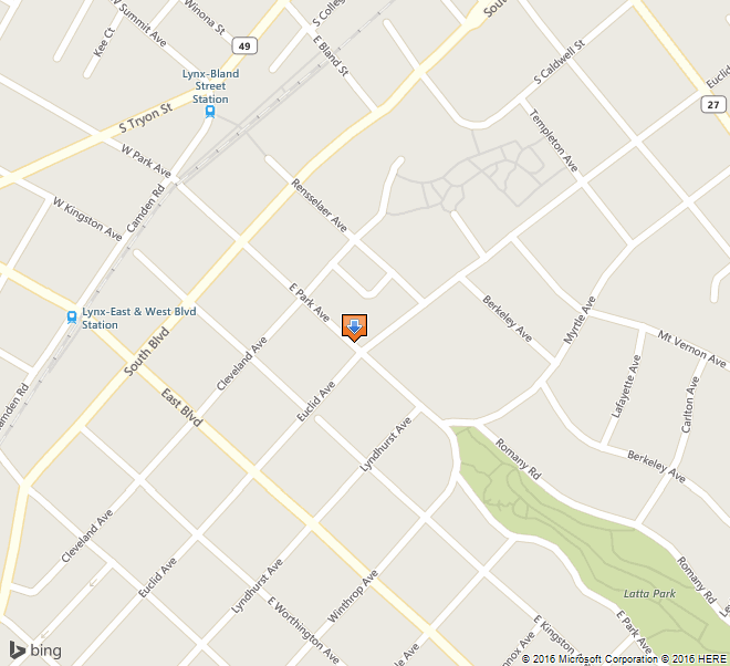
1. Name and location of the property: The property known as the Robert J. Walker House is located at 329 E. Park Ave. in Charlotte, N.C.

2. Name, address and telephone number of the present owner and occupant of the property: The present owner and occupant of the property is:
Kenneth D. Williams, Jr. and wife, Helen C. Williams
329 E. Park Ave.
Charlotte, N.C. 28203

Telephone: (704) 334-4477

3. Representative photographs of the property: This report contains representative photographs of the property.

4. A map depicting the location of the property: This report contains a map which depicts the location of the property.

walker-map

5. Current Deed Book Reference to the property: The most recent deed on this property is recorded in Mecklenburg County Deed Book 3482 at Page 294. The Tax Parcel Number of the property is 123-071-07.

6. A brief historical sketch of the property:

On June 9, 1901, the Charlotte Observer reported that the architectural firm of Hook and Sawyer was designing several buildings in Charlotte and its environs, including the home of Robert J. Walker in Dilworth, Charlotte’s initial  streetcar suburb.1  Charles Christian Hook (1870-1938) and Frank M. Sawyer had established their partnership in October 1898, soon after Sawyer had moved to Charlotte from Anderson, S.C.2 C. C. Hook, a native of Wheeling, W.Va., and graduate of Washington University in St. Louis, Mo., was Charlotte’s first resident architect.3 He had come to this community in 1891 to teach mechanical drawing in the Charlotte Graded School, which was situated in the building at the northern edge of Dilworth that had formerly housed the North Carolina Military Institute.4 By 1892, Hook had entered private practice as an architect.5 By the end of his career, Hook had established himself as an architect of importance not only to Charlotte but also to the Piedmont sections of the two Carolinas. Locally, he fashioned such imposing edifices as the Charlotte Woman’s Club, the  Charlotte City Hall, the James B. Duke Mansion and the Charlotte Masonic Temple, to mention only a few.6 He designed houses in Gastonia, Salisbury, Spartanburg and elsewhere.7 Most of his early commissions, however, were for houses in Dilworth, the streetcar suburb that the Charlotte Consolidated Construction Company or Four C’s had opened on May 20, 1891.8 Indicative of Hook’s identification in the public mind with the early residential architecture of Dilworth was an article which appeared in the Charlotte Observer on May 20, 1897. “An advertisement that always shows for Mr. Hook’s skill and taste is to be found in the houses in Dilworth, which he designed, and which show the best features of modern architecture,” the newspaper proclaimed.9 Hook was a specialist in the Colonial Revival style; but he did render houses in the  Queen Anne style, an architectural motif which achieved its greatest popularity during the Victorian era.10 Only two Queen Anne style homes that one can definitively attribute to C. C. Hook survive in Dilworth. They are the Mallonee-Jones House (1895), which has already been designated as “historic property” upon the recommendation of the Historic Properties Commission, and the Robert J. Walker House (1901) at 329 E. Park Ave.

Robert Jefferson Walker (1870-1923) and his wife, Hattie Chariton Walker (1876-1967), moved into their new home in Dilworth in November 1901.11 Having grown up in Charleston, S.C., he was a regional representative for the Berlin Aniline Works, a German firm which produced dyestuffs. After the outbreak of World War I, Mr. Walker continued his association with the dyestuffs industry as a representative for the Atlantic Dyestuffs Company. At the time of his death on July 11, 1923, he was also president of the Charlotte Knitting Company.12 In the opinion of the Charlotte News, Robert J. Walker was “prominently connected in community affairs.” 13 He was a member and vestryman at  Holy Comforter Episcopal Church in Dilworth; he served on the Board of Directors of St. Peters Hospital in Fourth Ward and on the Board of Directors of Thompson Orphanage. He was a Mason and a Shriner.14

Mattie Chariton Walker lived in the house for many years after her husband’s death. After an extended illness, she died in the Wesley Nursing Center in Charlotte on November 3, 1967. She was ninety-one years old. A native of Savannah, Ga., Mrs. Walker, in keeping with the values and customs of her upbringing, devoted most of her time and energy to rearing the six children (three boys and three girls) which she and Mr. Walker had brought into this world. She was also a charter member of Holy Comforter Episcopal Church and an active participant in the Daughters of the American Revolution. 15

On October 4, 1972, Kenneth D. Williams, Jr., and his wife, Helen C. Williams, bought the house from Mary Belle N. Lowry, who had owned the property since May 1944 and had resided there as well. Mr. and Mrs. Williams have been meticulously restoring the house. Happily, Mr. Williams is an architect. 16
Footnotes:

1 Charlotte Observer (June 9, 1901), p. 5.

2 Charlotte Observer (October 13, 1898), p. 5.

3 George Welch, a resident of Charlotte, did design several structures in the community in the 1870’s, including Second Presbyterian Church, the opera house and the jail. None of these structures is extant. Apparently, Welch was not a professional architect (Charlotte News (April 15, 1901), p. 1.).

4 Charlotte News (September 17, 1938), p. 12.

5 Charlotte Observer (April 3, 1892), p. 4.

6 Dan L. Morrill and Ruth Little Stokes, “Survey and Research Report on the Clubhouse of the Charlotte Woman’s Club.” (a manuscript produced for the Charlotte-Mecklenburg Historic Properties Commission, April 1978). Dan L. Morrill and Jack O. Boyte, “Survey and Research Report on Lynnwood (James B. Duke House).” (a manuscript produced for the Charlotte-Mecklenburg Historic Properties Commission, January 1977). Dan L. Morrill and Caroline I. Mesrobian, “Survey and Research Report on the Charlotte City Hall.” (a manuscript produced for the Charlotte-Mecklenburg Historic Properties Commission, February 1980). Dan L. Morrill and Laura A. W. Phillips, “Survey and Research Report on the Masonic Temple.” (a manuscript produced for the Charlotte-Mecklenburg Historic Properties Commission, April 1980).

7 For a representative sample of the work of Hook and Sawyer, see Some Designs By Hook & Sawyer, Architects, Charlotte, N.C., 1892-1902 (Queen City Printing & Paper Co., Charlotte, N.C.). A copy is available in the Carolina Room of the Charlotte-Mecklenburg Public Library.

8 Charlotte News (May 20, 1891), p. 1. The president of the Charlotte Consolidated Construction Company was Edward Dilworth Latta.

9 Charlotte Observer (May 20, 1897), p. 3.

10 Charlotte Observer (September 19, 1894), p. 4.  Charlotte Observer (June 4, 1893), p. 6.

11 Charlotte Observer (November 7, 1901), p. 5.

12 Charlotte Observer (July 12, 1923),p. 5.

13 Charlotte News (July 12, 1923), p. 6.

14 Charlotte Observer (July 12, 1923), p. 5.

15 Charlotte Observer (November 4, 1967), p. 4B.

16 Interview of Helen C. Williams by Dr. Dan L. Morrill (October 28, 1980). Mecklenburg County Deed Book 1125, Page 19. Mecklenburg County Deed Book 3482, Page 294. The original deed to the property is recorded in Mecklenburg County Deed Book 168, Page 220.

7. A brief architectural description of the property: This report contains an architectural description of the property prepared by Caroline I. Mesrobian, Architectural Historian.

8. Documentation of why and in what ways the property meets the criteria set forth in N.C.G.S. 160A-399.4:
a. Special significance in terms of its history, architecture and/or cultural importance: The Commission judges that the property known as the Robert J. Walker House does possess special historic significance in terms of Charlotte-Mecklenburg. The Commission bases its judgment on the following considerations: 1) it is one of only two known Queen Anne style houses in Charlotte which can be attributed to C. C. Hook, an architect of local and regional importance; 2) it is one of the few Victorian style houses which survive in Dilworth, Charlotte’s initial streetcar suburb.

b. Integrity of design, setting, workmanship, materials, feeling and/or association: The Commission judges that the architectural description included herein demonstrates that the property known as the Robert J. Walker House meets this criterion.

9. Ad Valorem Tax Appraisal: The Commission is aware that designation would allow the owner to apply annually for an automatic deferral of 50t of the Ad Valorem taxes on all or any portion of the property which becomes “historic property.” The current Ad Valorem appraisal on the Robert J. Walker House is $12,780. The current Ad Valorem appraisal on the .192 acres of land is $2,750. The most recent Ad Valorem tax bill for the house and land was $314.54. The land is zoned R6MF.
Bibliography

. Charlotte News

Charlotte Observer

Interview of Helen C. Williams by Dr. Dan L. Morrill (October 28, 1980) .

Dan L. Morrill and Jack O. Boyte, “Survey and Research Report on Lynnwood (James B. Duke House).” (a manuscript produced for the Charlotte-Mecklenburg Historic Properties Commission, January 1977).

Dan L. Morrill and Ruth Little Stokes, “Survey and Research Report on the Clubhouse of the Charlotte Woman’s Club.” (a manuscript produced for the Charlotte-Mecklenburg Historic Properties Commission, April 1978).

Dan L. Morrill and Caroline 1. Mesrobian, “Survey and Research Report on the Charlotte City Hall.” (a manuscript produced for the Charlotte-Mecklenburg Historic Properties Commission, February 1980) .

Dan L. Morrill and Laura A. W. Phillips “Survey and Research Report on the Masonic Temple.” (a manuscript produced for the Charlotte-Mecklenburg Historic Properties Commission, April 1980) .

Records of the Mecklenburg County Register of Deeds Office.

Records of the Mecklenburg County Tax Office.

Some Designs By Hook & Sawyer, Architects, Charlotte, N.C., 1892-1902 (Queen City Printing & Paper Co., Charlotte, N.C.).

Vital Statistics of Mecklenburg County.

Date of Preparation of this Report: November 5, 1980

Prepared by: Dr. Dan L. Morrill, Director
Charlotte-Mecklenburg Historic Properties Commission
3500 Shamrock Dr.
Charlotte, N.C. 28215

Telephone: (704) 332-2726
Architectural Description


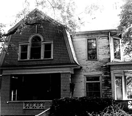
This  Queen Anne style house, located on the northwest quadrant of the intersection of Euclid and E. Park Avenues in Dilworth, was designed by Charles C. Hook for Robert J. Walker in 1901. The two story frame house, with basement and high attic, is a fine example of Victorian eclecticism, with a variety of wall surfaces, porches, roof lines, and window types.

The front elevation (southwest) features a  wood shingled porch which shelters the central entrance and a  double hung, 1/1 window. This section of the facade, which projects from the main block of the house, is accentuated by a  gambrel roof, it featuring a large Palladian window. The remainder of the facade, which is weatherboarded, contains a first story picture window with stained glass  transom and a second story double hung, 1/1 window. A tiny oriel window punctuates the steeply pitched  gable roof. A one story porch with classical columns spans the intersection of this facade and the right side elevation (southeast) a bay window faces the intersection of E. Park and Euclid Avenues on both stories.

An exterior chimney with central, arched recess dominates the right side elevation. Fenestration includes a picture window with stained glass transom and double hung, 1/1 windows of varying sizes in the second story as well as in the recessed section on the first floor. Oval end windows pierce the double gable roof. A single bay, rear wing features a double hung, 2/2 window. The side of this wing which faces the rear elevation (northeast) contains two centrally placed double hung, 2/2 windows, the upper one within the gambrel roof end. The main block contains an end, double hung, 2/2 window on both stories.

The left side elevation (northwest), which once overlooked the Walker’s side yard and garden, is perhaps the most varied of all the house’s elevations. It is comprised of the main block flanked by a rear wing with side entrance reached by a single flight of stairs, and a front wing featuring the side of the porch which faces onto E. Park Ave. Above this is a small oriel window. The main block is punctuated by double hung, 2/2 windows flanking a central, projecting bays it contains an attenuated double hung window which lights the interior stairwell. An interior chimney projects from the gable roof end.

On the interior, the first floor (ceiling height 11 feet) contains four major rooms which flow into one another in a circular fashion through double sliding doors. The entrance hall (southwest) features a massive staircase which rises two flights to the second floor. A fireplace, comprised of a classical mantel with columns and bead and reel decoration and a marbleized tile surround and hearth is located beneath the stairway. The floor, as in the other public rooms, hasa parquet border; this particular one is formed by narrow oak boards stained in several different shades for contrasting effect.

The parlor (southeast) is the most elegant room in the house. Plaster relief panels in the form of intertwined leaves divide the wall areas; the walls themselves still show remnants of a jade green satin damask fabric bearing an iris pattern. The corner mantel and mirrored overmantel adorned with classical columns are of bird’s-eye maple and have never been painted. The parquet floor appears to be composed of oak, maple, and mahogany, and is laid in an interlocking fret pattern. The ceiling fixture is of solid brass and is original to the house.

The east back room, the dining room, features a corner mantel with brackets and attenuated columns. Its surround and hearth are composed of marbleized green tiles moulded in the shape of shells. Bands of variously shaded, stained wood form the border of the floor. A butler’s pantry and kitchen are behind the dining room, while the room directly behind the entrance hall (northwest) was used originally as a den.

The second floor (ceiling height 10 feet) contains five major rooms; three of them were used by the Walker family as bedrooms and a nursery. The small room above the den was used as an office by Mr. Walker, while the back room directly above the kitchen wing was the servant’s quarters.

The 1911 Sanborn Insurance Map shows that a stable and automobile garage were located at the rear of the property. Neither exist today; the stable was demolished before the 1929 Sanborn Insurance inventory was taken.


Bryant Park

1. Name and location of the property: The property known a Bryant Park is located at 1701 West Morehead Street in Charlotte, NC. (UTM: 17 511932E 3898077N)
2. Name and address of the current owner of the property:
The current owner of the property is:

Mecklenburg County

600 East 4th Street

Charlotte, NC

3. Representative photographs of the property: This report contains representative photographs of the property.

4. A map depicting the location of the property: This report contains a map depicting the location of the property.

5. Current deed book reference to the property: The most recent deed to the property is found in Mecklenburg County Deed Book 1044, page 216. The tax parcel number for the property is 67-014-01.

6. A brief historical sketch of the property: This report contains a brief historical sketch of the property prepared by Emily D. Ramsey.

7. A brief physical description of the property: This report contains a brief physical description of the property prepared by Emily D. Ramsey.

8. Documentation of why and in what ways the property meets the criteria for designation set forth in N.C.G.S. 160A-400.5.

a. Special significance in terms of its history, architecture, and/or cultural importance. The Charlotte-Mecklenburg Historic Landmarks Commission judges that Bryant Park possesses special significance in terms of Charlotte-Mecklenburg. The Commission bases its judgment on the following considerations:1. Bryant Park, constructed in the mid-1930s to serve residents in the neighborhood of Wesley Heights, was one of the first small scale public parks in Charlotte, and represents the early stages of the twentieth century push for neighborhood public green space.2. Bryant Park’s complex network of granite stone walls and distinctive stone seating above the softball field was completed during the height of the Great Depression, most likely as part of the Works Progress Administration (the W.P.A.), and remains as possibly a tangible reflection of the local impact of New Deal work programs.

3. Located in an increasingly dense area of urban development (now escalating after the completion of nearby Ericsson Stadium), Bryant Park is the only public park and green space remaining in Charlotte’s West Morehead Street industrial sector.

b. Integrity of design, workmanship, materials, feeling, and association.

The Commission contends that the architectural description by Emily D.

Ramsey demonstrates that Bryant Park meets this criterion.9. Ad Valorem Tax Appraisal: The Ad Valorem Tax value of the 6.6 acres of land and all improvements on the property is $395,310. The property is zoned I-2.

Date of Preparation of this Report:

August 1, 2001

Prepared By:

Emily D. Ramsey

745 Georgia Trail

Lincolnton, NC 28092

Statement of Significance

Bryant Park

1701 West Morehead Street

Charlotte, NC

Summary

Bryant Park, begun in 1930 and completed during the height of the Great Depression, is a property that possesses local historic significance as one of Charlotte’s first small-scale public parks, and  as a tangible reminder of the early stages of the twentieth century push for public green space within the city. Although Latta Park, Charlotte’s first public park, was completed with much fanfare in the early 1890s, the concept of public recreational and natural green spaces gained acceptance slowly among city officials. Despite the creation of the Charlotte Park and Tree Commission in 1904, in the years between the turn of the century and the end of World War II the city’s parks system continued to rely on the staunch support of Charlotte-Mecklenburg’s private sector, rather than the support and funding of local government. Established on land donated by prominent developer E. C. Griffith, Bryant Park was one of the first projects of the Charlotte Park and Recreation Commission, which replaced the Charlotte Park and Tree Commission in 1927. Independence Park, Latta Park and Revolution Park, established in the years before the Great Depression, were large, sprawling expanses of carefully landscaped natural areas (Revolution Park encompassed over 240 acres), funded in large part by private funds and located outside of the center city area to service newly developed garden suburbs. The creation of Bryant Park in the early years of the Charlotte Park and Recreation Commission heralded a new kind of green space, the small neighborhood park, which would become extremely popular in the boom period after World War II. Although small and minimally landscaped, these parks would provide recreation space for the majority of Charlotte’s residents throughout the twentieth century.


Bryant Park is also significant as the earliest public park established within one of Charlotte’s most prolific industrial sectors, stretching along West Morehead Street. Serviced by a line of the Southern Railroad (which connected Charlotte to the nearby textile center of Gastonia) and connected to center city Charlotte by a newly constructed streetcar line, the area west of Charlotte’s central business district quickly developed into a thriving industrial district. Developers erected rows of working class houses in the Wilmore and Wesley Heights neighborhoods, and working class families flocked to west Charlotte in the early decades of the twentieth century. Bryant Park, located between Wesley Heights and Wilmore, provided west Charlotte residents with green space for a welcome respite from the noise of the factories and with specialized spaces (including a softball field, tennis courts, a volleyball court, and horseshoe pits) for a variety of recreational activities. Although the park has since lost many of these recreational amenities, Bryant Park, with its terraced hillside leading down to a wide expanse of green playing fields, and with its intricate and distinctive stonework, remains an important reminder of the evolution of green space within Charlotte’s urban landscape.
Bryant Park’s development began in 1929-1930, but was stymied by the onset of the Great Depression, when public monies became scarce. The park’s construction, which primarily involved the construction of a complex configuration of stone boundary walls, terrace walls and stone seating for the large softball field, was completed during the height of the Great Depression, most likely with funding and labor provided by the Work’s Progress Administration, a federal government agency created by New Deal legislation to give local men and women needed jobs. Although the impact of New Deal work programs in Charlotte were most visible in the few large-scale projects like Memorial Stadium, Bryant Park reflects the influence of Federal programs on the neighborhood level.

Historical Background and Context Statement

The concept of public green space, although fully developed among academic circles and within northern cities by the end of the nineteenth century, did not gain widespread acceptance in New South cities like Charlotte until well into the twentieth century. In the mid-nineteenth century, cemeteries often served double duty as recreational green space, where residents and visitors could go to escape the noise and congestion of the city, and Charlotte continued to use their shady, quiet cemeteries as impromptu parks until the turn of the century . Charlotte had experienced unprecedented economic and physical growth in the last decades of the nineteenth century, yet “the amount of green space within the city . . . remained a constant: Settlers’ and Elmwood cemeteries.”1 Not surprisingly, Charlotte-Mecklenburg’s New South leaders, who had transformed Charlotte from a small farming community into a regionally important cotton trading and textile center, were among the first to grasp the importance of green space as an integral part of the city’s built environment. Entrepreneurs such as Edward Dilworth Latta, George Stephens, and Daniel Augustus Tompkins threw their support behind the concept of public green space by creating impressive, meticulously planned early examples of garden suburbs like Myers Park and Dilworth and neighborhood parks like Latta Park and Independence Park..

Initially, Charlotte seemed ready to embrace full-scale, long term city planning and the development and preservation of green spaces. Inspired by the success of Myers Park, the Charlotte Chamber of Commerce hired John Nolen, Myers Park’s designer, to conduct a civic survey and create a comprehensive city plan to control and direct future growth.2 Despite the city’s initial enthusiasm, Nolen’s ambitious plan for Charlotte’s growth, which included room for parks, lush garden suburbs and a scenic byway, was ultimately rejected by the Chamber, a decision which would affect the evolution of Charlotte-Mecklenburg’s green space for the rest of the century. Without financial support from the city and local government, green space developed only where sufficient private funds existed to pay for it. Not surprisingly, the first park established within the Charlotte area was created by businessman and developer Edward Dilworth Latta. Latta Park, completed in 1890, encompassed over seventy acres in the middle of the newly developed Dilworth neighborhood, but, with its large recreational lake and scenic walkways, it attracted people from all over Charlotte, and created interest in the possibility of green spaces within Charlotte’s center city communities.

Although interest in and demand for public parks grew significantly in the late nineteenth and early twentieth century, Charlotte’s government remained too small and unorganized to take on the responsibility of public green spaces. As historian Brian Sturm writes, Charlotte’s Board of Aldermen “refused to make parks a city priority because of the assumption that recreation was not the business of city government.”3 Once again, private interests came through to support the development of a formal government body devoted to establishing public parks and green spaces. D. A. Tompkins exerted his significant influence with the city, and lobbied tirelessly in favor of public parks in general and, specifically, the development of Independence Park, Charlotte’s first municipal park. Public parks, Tompkins argued, would bring upper and working classes together and were an important part of a productive work environment. “There are working people in our factories,” he told the Board, “who scarcely ever see the green grass, flowing water, and waving trees of the country. The park will afford them these with the few aides of nature we can put out there.”4 Tompkins succeeded, despite the apathetic nature of the board – in 1904, the Charlotte Park and Tree Commission was established, with Independence Park as the commission’s first project.5 After Independence Park’s completion, however, the activity of the Charlotte Park and Tree Commission practically ceased, due to lack of funding. Even with Tompkins serving as chair, the commission failed to create significant green spaces during the early decades of the twentieth century, despite the fact that Charlotte’s economy was booming and public buildings were being constructed at an unprecedented rate.6


In the late 1920s, E. C. Griffith, a prominent local developer and large center city landowner, donated 16 acres of land between the Wilmore and Wesley Heights neighborhoods in the rapidly developing industrial sector of west Charlotte to the Charlotte Park and Recreation Commission.7 The plot of land, named Bryant Park, was slated for development as a small neighborhood recreational center. Work began tentatively in 1930, but the onset of the Great Depression and subsequent shrinking budget forced the Charlotte Park and Recreation Commission to stop work on most of its projects, including Bryant Park.8
The push for public green space entered its second stage in the year 1927, when the Charlotte Park and Tree Commission became the Charlotte Park and Recreation Commission. Although the new commission received funds through a small city tax, it remained financially unable to build new parks without the help of private funds. However, with several parcels of land, ranging from over 200 acres to less than ten acres, donated by wealthy local entrepreneurs, the commission began, slowly but surely, establishing parks in Charlotte. Most of these new parks, in contrast to Latta Park, Independence Park, and the recently completed Revolution Park, were mainly small parcels of land developed to serve specific neighborhoods. Bryant Park was among the first of these small neighborhood parks.

Despite the initial complications caused by the severe economic downturn of the late 1920s and early 1930s, the New Deal programs of the Roosevelt administration that came out of the Great Depression proved to be “a boon to parks and recreation” programs across the country. The Charlotte Park and Recreation Commission received Federal funds for a variety of projects, with most of the money and labor coming from the Works Progress Administration (later renamed the Works Projects Administration) and the Civilian Conservation Corps. Although only the biggest of Charlotte’s Federal parks projects, including Memorial Stadium and the city’s first municipal swimming pool, received widespread attention, a variety of small park projects that had been stalled by the economic slowdown were completed with the help of 1930s New Deal work programs. Bryant Park was most likely one of the small park projects to benefit from these Federal programs. The elaborate stonework seen throughout Bryant Park, which created seating for the park’s softball field and circled the perimeter of the park as a network of low walls, is nearly identical to the stonework used in W.P.A. projects across North Carolina, including the stonework in nearby Independence Park, which was completed in part through Federal funding during the 1930s.9 Moreover, the park was completed by the early 1940s, before the 1949 bond initiative that promised to create “a playground within a half-mile of every home” in Charlotte-Mecklenburg, and well before the 1950s boom period for parkland acquisition.10 As one of the earliest small public parks completed in Charlotte, Bryant Park was a model for the dozens of neighborhood parks constructed in the post-war period, and, with its softball field, volleyball and tennis courts, and horseshoe pits, it served as a recreational center for the surrounding Wesley Heights and nearby Wilmore  neighborhoods. However, as the Charlotte Mecklenburg Park and Recreation Commission suffered from ongoing lack of funding in the 1960s and 1970s, and as more and more industrial development crowded along the main artery of West Morehead Street in the last half of the twentieth century, Bryant Park lost many of its original recreational spaces. The park today has retained only 6.6 of its original 16 acres, and the only designated recreational space that remains is the centerpiece of Bryant Park, the softball field.


Bryant Park, set among the dense clustering of low brick industrial buildings that line West Morehead Street, is also locally significant as the earliest public park established within one of Charlotte’s most prolific industrial sectors, stretching along West Morehead Street. Serviced by a line of the Southern Railroad (which connected Charlotte to the nearby textile center of Gastonia) and connected to center city Charlotte by a newly constructed streetcar line, the area west of Charlotte’s central business district quickly developed into a thriving industrial district. Prominent businesses such as the Grinnell Company and the Coca-Cola Company built their plants along West Morehead Street Developers such as F. C. Abbott erected rows of working class houses in the Wilmore and Wesley Heights neighborhoods, and working class families flocked to west Charlotte to work and live in the early decades of the twentieth century.11 The construction of Bryant Park in the 1930s reflected the increasing importance of these west Charlotte working class neighborhoods and the industrial economy they supported.
Physical Description and Site Context

Bryant Park comprises 6.6 acres of terraced hillside and flat playing field, bound on the north by West Morehead Street, on the west by Suttle Avenue, and on the east by a small creek bed. The main entrance to the park is located on the south end of the property, on the park’s highest elevation, and leads to the most impressive feature of the park – the stone seating for the park’s only remaining recreational space, the softball field. A complex network of steps, walls of varying heights, and wide benches are arranged organically into the steeply sloping hillside, and, from a distance, seem almost to be a natural outcropping. The stone bleachers, like the retaining walls along the terraced hill south of the softball field and the low walls and entrance that line the north side of the park, along West Morehead Street, are made of a thick layer of common stone and rubble faced with more finished granite stones. A shady, steeply sloped area to the west of the softball field is dotted with benches and mature trees. The hilly area and the softball field on the southern end of the park give way to a broad, uninterrupted expanse of green lawn, which stretches north to West Morehead Street. As the only green space located within the industrial sector of west Charlotte, which once provided the residents Wilmore and Wesley Heights with a welcome respite from the noise of the factories and with specialized spaces (including a softball field, tennis courts, a volleyball court, and horseshoe pits) for a variety of recreational activities, and as one of the earliest public parks completed in Charlotte, Bryant Park remains an integral part of the city’s built environment and a visual reminder of the evolution of green space within Charlotte’s urban landscape.

_________________________________

1.  Brian W. C. Sturm, “The Evolution of Green Space: A History of Urban Landscape in Charlotte, North Carolina, 1890-1990” (honors thesis, University of North Carolina at Chapel Hill, 2000), 1-2.

2.  Thomas W. Hanchett, “Charlotte’s Neighborhood Planning Tradition,” (Charlotte-Mecklenburg Historic Landmarks Commission, 1986), 3.

3.  Sturm, 21.

4.  The Charlotte Observer, August 2, 1904.

5.  The Charlotte Observer, November 8, 1904 and Jun 6, 1905.

6.  Ibid.

7.  Legette Blythe and Charles R. Brockmann, Hornet’s Nest: The Story of Charlotte and Mecklenburg County (Charlotte, 1961).

8.  The Charlotte Observer, February 28, 1950.

9.  J. S. Curt, W. A. Cutter, and Thomas Morse, Emergency Relief in North Carolina: A Record of the Development and Activities of the North Carolina Emergency Relief Administration (Raleigh, 1936).

10.  Sturm.  Clippings from file labeled “Parks and Recreation,” located in the Vertical files of the Robinson Spangler North Carolina Room of the Charlotte Mecklenburg Public Library.

11.  Dr. Dan L. Morrill, “Survey and Research Report on the Electric Supply and Equipment Company” (Charlotte Mecklenburg Historic Landmarks Commission).


Walter Brem House

This report was written on July 12, 1983

1. Name and location of the property: The property known as the Walter Brem House is located at 211 East Boulevard, in Charlotte, North Carolina.

2. Name, address and telephone number of the present owner of the property: The present owner of the property is:

Mr. Henry Blume
3601 Kelway Avenue
Charlotte, N.C. 28210

Telephone: 552-6391

3. Representative photographs of the property: This report contains representative photographs of the property.

4. A map depicting the location of the property: This report contains a map which depicts the location of the property.


5. Current Deed Book Reference to the property: The records of the Mecklenburg Tax Office do not contain a current deed book reference to the property. The Tax Parcel Number of the property is: 123-0742.

6. A brief historical sketch of the property: This report contains a brief historical sketch of the property prepared by Dr. William H. Huffman.

7. A brief architectural description of the property: This report contains an architectural description of the property prepared by Lisa A. Stamper.

8. Documentation of why and in what ways the property meets the criteria set forth in N.C.G.S. 160A-399.4:


a. Special significance in terms of its history, architecture, and/or cultural importance: The Commission judges that the property known as the Walter Brem House does possess special significance in terms of Charlotte-Mecklenburg. The Commission bases its judgment on the following considerations: 1) the Walter Brem House, erected in 1902-03, was designed by C. C. Hook, Charlotte’s first permanent resident architect and an architect of local and regional significance; 2) the original owner, Walter Brem, was married to the daughter of Governor Todd Robinson Caldwell, was an early business associate of George Stephens, develop of Piedmont Park and Myers Park, and was an important civic leader in Charlotte until his death in 1925; 3) Mr. R. D. Craver, a subsequent owner, was a pioneer in the motion picture business in the two Carolinas; 4) the Walter Brem House is one of the earliest and grandest examples of the Colonial Revival style in Charlotte; 5) the Walter Brem House is one of the oldest houses on East Boulevard and occupies a strategic townscape position in Dilworth, Charlotte’s first streetcar suburb.

b. Integrity of design, setting, workmanship, materials, feeling and/or association: The Commission contends that the attached architectural description by Miss Lisa A. Stamper demonstrates that the Walter Brem House meets this criterion.

9. Ad Valorem Tax Appraisal: The Commission is aware that designation would allow the owner to apply for an automatic deferral of 50% of the Ad Valorem taxes on all or any portion of the property which becomes “‘historic property.” The current appraised value of the .321 acres of land is $42,000. The current appraised value of the improvements is $55,420. The total current appraised value is $97,420. The property is zoned B1.

Date of Preparation of this Report: July 12, 1983

Prepared by: Dr. Dan L. Morrill, Director
Charlotte-Mecklenburg Historic Properties Commission
218 N. Tryon Street
Charlotte, North Carolina 28202

Telephone: 704/376-9115


Historical Overview
 

Dr. William H. Huffman
August, 1981

In July, 1902, the Charlotte Consolidated Construction Company, otherwise known as the Four C’s, began building one of the early houses on Boulevard East in the new streetcar suburb of Dilworth for Walter and Hannie Caldwell Brem. 1 The Four C’s was organized in 1890 by Edward Dilworth Latta to develop 250 acres of rural land south of the city, the accomplishment of which was facilitated by the opening of Charlotte’s first trolley line from the Square to Latta Park in 1891. The Brems had engaged C. C. Hook, Charlotte’s first resident architect, to design the house. 2 Charles Christian Hook (1870-1938) had settled in Charlotte in 1891 to teach in the Charlotte Graded School at South Boulevard and E. Morehead Streets. His arrival in the same year as the beginning of the Four C’s development of Dilworth resulted in many early commissions for dwellings in that community. Some of the best known structures designed by Hook were the Charlotte City Hall and the James B. Duke mansion. 3

Sketch of the Walter Brem house

from “Some Designs,” a promotional booklet published by Hook & Sawyer Architects ca. 1902

Walter Brem was born in Charlotte July 31, 1849, and was one of the few citizens of the city whose parents were also born in town. He was the son of Col. Thomas H. Brem, commander of Brem’s Battery in the Civil War, and Martha Fox Brem, who descended from the prominent Erwin family of Burke County. Walter Brem, in association with William H. Martin, was at one time the owner of a hardware store at the southeast corner of Trade and Tryon Streets, and, about 1890, went into the insurance business with George S. Stephens, who was a college friend of his son’s from Chapel Hill. In 1902, Mr. Stephens married Sophie Myers, daughter of John Springs Myers, and subsequently developed his father-in-law’s 1200-acre farm into the Myers Park subdivision. Mr. Brem spent the remainder of his business career as head of Walter Brem and Sons, general agents for the Traveler’s Insurance Co. During his life he was actively involved in the Charlotte public school system and the city YMCA. He died at the age of 76 on February 11, 1925. 4

Hannah Caldwell Brem, who was born in Morganton on November 4, 1851 and died in Charlotte April 21, 1931, was the daughter of Governor Todd Robinson Caldwell of Morganton. 5 The Brems had four children: Dr. Walter Brem (a fraternity brother of, and semi-pro ballplayer with George S. Stephens), who practiced medicine in Los Angeles; Todd Robin Brem, Mina Brem (Mrs. Robert A.) Mayer, and Helen Brem (Mrs. R. R.) Beatty, all of Charlotte. In 1903, when they moved into the fine house on Boulevard East (for which they paid $6045.86), the latter three children were still at home, but Mina Brem was married later that same year and no longer lived at the residence. 6 In 1912, the Brems bought a smaller, Queen Anne style house a block to the east of the one they had built, which was constructed eight months after theirs. 7 Their original house was rented briefly and stood vacant for some months before it was sold to Regger D. Craver in 1914 for the consideration of $9000.00. 8

Mr. Craver was a pioneer in the motion picture business in the Carolinas. At one time, he was one of the largest individual theater owners in the South, which included movie houses in the Carolinas and Virginia. In Charlotte, he operated the old Broadway theaters on East Trade and West Trade Streets, and afterward operated the Broadway theater on South Tryon. The Cravers lived on East Boulevard with their four sons, Gilda, R. D., Jr., William and Alton. In 1928, Mr. Craver was stricken and died after a brief illness at the age of 50. He was survived by the children and his wife, the former Bessie Jenkins of Gastonia. 9 Mrs. Craver continued to live in the house after he husband’s death, but apparently could not maintain it when the Great Depression hit with full force, for in 1931, it was sold at a foreclosure sale to the South Atlantic Investment Corp. for $8470.64. 10

Once more the house stood vacant as it changed owners among investors twice in 1932, then went back to the ownership of the South Atlantic Investment Corp. in 1934. 11 In the latter year, the house was rented to Thomas K. Culp, a foreman for the Southern Power and Utility Company, who remained until it was purchased in 1936 by Mrs. Mae King Blume. 12 Mrs. Blume, the widow of John H. Blume, converted the property to the Colonial Apartments, a name which was maintained for many years. 13 In 1936, Mrs. Blume was the proprietor of the Piedmont Hotel, Queen City Hotel, Frances Hotel, Windsor Hotel, Southern Hotel, the Franklin Hotel and the manager of the New Albert Hotel. 14 Mrs. Blume moved to 211 E. Boulevard in 1939, and has lived there to this date. 15


NOTES

1 Charlotte Observer, July 15, 1902, p. 6.

2 Some Designs by Hook and Sawyer, Architects, Charlotte, N.C. (Charlotte: Queen City Printing, 1902, p. 38.

3 “Survey and Research Report on the Seaboard Air Line Railroad Passenger Terminal,” Charlotte Mecklenburg Historic Properties Commission, undated.

4 Charlotte Observer, Feb. 12, 1925, p. 4; Interview with Dr. Walter Brem Mayer, 28 July 1981.

5 Certificate of Death, Book 48, p. 615; Charlotte Observer, Feb. 12, 1925, p. 4.

6 See note 4; Deed Book 173, p. 497, 20 Feb. 1903.

7 The house was built for William G. Crutchfield, who purchased it from the 4 C’s on 13 Oct. 1903. (Deed Bk. 182, p.8) See “Historical Sketch of the Crutchfield House,” by Dr. William H. Huffman, Charlotte-Mecklenburg. Hist. Prop Comm., August, 1981.

8 Charlotte City Directory, 1913, p. 530; 1914, p. 591; Deed Book 327, p. 574, 7 Sept. 1914.

9 Charlotte Observer, Dec. 20, 1928, p. 6.

10 Deed Book 809, p. 487, 14 Nov. 1931.

11 Deed Book 814, p. 593, 28 April 1932; Deed Book 827, p. 49, 25 Oct. 1932; Deed Book 849, p. 266, 20 Feb. 1934.

12 Deed Book 900, p. 467, 9 May 1936.

13 Charlotte City Directory, 1937, p. 776 and subsequent years.

14 Ibid., 1936, p. 105.

15 Ibid., 1939, p. 747.


Architectural Description
 

by Lisa Stamper

Located near the corner of East and South Boulevards, the Walter Brem house still exhibits the grandeur of the fine Colonial Revival homes of the turn of the century. One of Charlotte’s first examples of the style, this magnificent two-story residence was designed by C. C. Hook, a prominent Charlotte architect. When erected in c. 1902-1903, East Boulevard was a fashionable residential street which was the showplace of Dilworth, the city’s first streetcar suburb. The Brem House has been added to over the years, and the original wooden clapboard siding has been covered with white asbestos siding. However, much of its fine detailing remains intact.

Originally, the Brem House was basically a rectangular house with two squarish, small ‘pavilions’ on both front corners. Between the projecting pavilions was a large one-story balconied entry portico. It also had a balconied one-story back porch. Over the years, numerous additions have been made to the back of the house. Also, an addition has been made to each side of the building.

The main portion of the house has a decorative slate tile roof, with a low pitch. It also has two small, symmetrically placed dormers at the front. the dormers are heavily pedimented and have diamond shaped glass panes. The two pavilions have flat roofs with broad bracketed eaves. Originally a wooden balustrade topped these roofs. These balustrades had heavy, paneled corner posts.

The Brem House has four original brick chimneys. Two identical exterior side chimneys bisect the sides of the pavilions. Another chimney is an interior one which is located in the back and off to one side. It was an interior chimney to avoid interference with the back porch design. the first two chimneys mentioned are thin, arcaded stacks with slightly stepped shoulders. The tops of these stacks have five courses of corbelling. These two chimneys have been painted brick red from the ground to the eaves, but have not been painted above the eaves. The interior chimney within the hipped roof is thicker and more square than the side chimneys. However, the five-course corbelled top is the same style. The back chimney is very simple. It is just a thin, rectangular stack without embellishment. New brick can be seen at the top of this chimney; therefore, possibly the top of this chimney once had corbelling like the others.

The composition of the impressive front facade was symmetrical and very well planned. Decorative corner boards on the second level of the wings lightened the second story as well as defined it. The first level was separated from the second level by horizontal wooden coursing. Repetition of the pedimented dormers was created by the pediment window heads of the second-level windows of the wings. On the second level, two more single-paned, double-hung windows were placed below the dormers. The first level of the front facade had for single-paned windows, topped with stained glass rectangular panels. Straight wooden window heads and frames unified the two types of glass. One windows was located in each wing, while the other two flanked the double door. The door was horizontally paneled with glass in its upper portion. Wooden pilasters flanked the door.

The front portico was magnificent. Six symmetrically placed columns held up the portico. These columns, along with the plain entablature, were of the Tuscan Order. Large projecting brackets support the projecting cornice. Its balustrade had six thick, paneled posts that corresponded to the columns below. However, these posts were thinner than those on the pavilions’ balustrades. These posts were topped with urns. Steps lead from the columns up to the porch deck, which extended from pavilion to pavilion. A railing identical in style to the pavilions’ balustrades enclosed the high porch.

Today, the corner boards are gone. One pediment window head is missing. A door has been placed between the two second story windows in the central section to allow access to the top of the portico. An awning covers the doors and windows. The portico’s wooden balustrade has been replaced with a simple, cast iron one. The other balustrades are gone. A side section of one porch was removed and a set of metal stairs was added. However, only one bracket is missing, the rest of the railing is intact, the columns are in excellent condition, the dormers seem unaltered, and the slate tile is still intact.

The sides of the house were identical before the additions were made. It is difficult to discern exactly how many windows were on each side, but it appears to have been six, four on each wing and two on the main portion, near the back. Both the first- and second-story windows were single-paned, double-hung sash. Probably all the windows of the Brem House, and definitely the ones on the sides and front, had dark, louvered shutters. None of these shutters remain on the house today.

The back facade is covered with a hodgepodge of additions, so it is difficult to determine what was once there. To visually balance the asymmetrically placed back chimney, a pediment was located on the back. From an early photograph, a corner of the back porch can be seen. The back porch was not as impressive as the front, but it also had a balustrade complete with urns, wide eaves, Tuscan Order columns, and a surrounding wooden rail. The columns, railing, etc., were removed when the back porch was converted into part of an apartment.

The additions are used as apartments, as is the original house. Some of the additions are two-story and some are one-story. Stairs run wild on the exterior of these additions. The additions have brick foundations, as does the original house. For uniformity, all the brick was painted, and white asbestos siding with wood grain texture was placed on all the additions and the original house.

Inside the Walter Brem House, the original floor plan seems to have been symmetrical, as befitting a Colonial revival style house. Many walls were later added to create apartments, especially on the second level, and original walls are often hard to identify. The first level rooms all have high ceilings, while the second level rooms all have standard height ceilings. All of the original flooring was probably of wood. Much of the original wall molding is intact. The first level original rooms still have their simple, horizontal wooden wainscoting along most of their walls.

The front entry door opens into a small foyer. Another wooden double door with eighteen glass panes (three panes by six panes) in each side opens into what was once the great hall and is currently used as a lobby. Except for a small additional wall at the left back corner, the great hall is practically unaltered. Much of the early paneled wainscoting and wooden chair rails are still intact. A chandelier was recently removed from the middle of the great hall.

The grand stair begins slightly to the left of the foyer, turns to continue up the back wall of the great hall, and turns once more to connect with the second level. Its wooden balustrade, with thick paneled posts resembling those of the exterior balustrades’ posts, is still intact. Also, the same type of wainscoting found on the great hall walls is found on the walls of the grand stair. Large round pendants hang from underneath the stair posts at the ceiling.

A brick mantel is located in front of the stair facing the front door, offset slightly to the right. Brick brackets support a wide wooden shelf. The fireplace is not currently used.

It appears that four doors lead from the sides of the great hall to the remainder of the home. One single eighteen glass-paned door leads to each pavilion room. The other doors lead to the back rooms of the home.

The mantle in the pavilion room to the right is very ornate. The mantle is mainly of wood, with a brick interior and an intricately-detailed solid metal screen. The mantel has flanking wooden stylized Ionic columns plus large brackets supporting the shelf. Egg and dart molding plus fine dentil molding is used freely in the design, as are garland and festoon ornamentation. It may be assumed that the other pavilion’s mantle is also very elaborate and similar in design. Neither of the pavilion fireplaces are currently in use.

The mantle at the back of the house is of very decorative brickwork. In the middle of the upper portion of the mantle a diamond shaped pattern is created with bricks. The upper portion is separated from the lower portion by massive corbelling. Vertical corbelling is also employed as a decorative feature. This is the only fireplace in the house still in use, according to Mr. Trull, resident of approximately 23 years.

East Boulevard runs in front of the Brem House. A driveway runs next to the South Boulevard side of the house and to the rear of the property. The back of the site is used as a small parking lot for residents. The front yard is well kept and landscaped. Boxwood foundation plantings dominate the yard.

Although a good bit of the interior and exterior decoration is missing from the Brem House, enough is still present to justify historic designation. Also, with the aid of an early photograph, copies of which are in the possession of the Charlotte-Mecklenburg Historic Properties Commission, a very accurate restoration could be made.

This grand home sits on the outskirts of Dilworth, in an area which is fighting to keep its historic character despite the insensitive commercial construction which is replacing many of its interesting earlier buildings. However, this area still has many of those turn of the century grand homes which have been beautifully restored and currently house a variety of businesses. The Brem House is currently for sale, and historic designation could save this home from losing all of its historic significance while encouraging buyers who would positively use the house as an asset to the community.


Bradford Farm and Store

Name and location of the property:  The property known as the Bradford Farm and Store is located at 15908 Davidson Concord Road in Huntersville, North Carolina.


Name, address, and telephone number of the current owner of the property:


The current owners of the property are:


House:

Elizabeth Bradford Milsaps

15908 Davidson-Concord Road

Huntersville, NC 28078

Telephone: (704) 875-2587


Store:

Mary Stewart Bost

P.O. Box 1245

Davidson, NC


Representative photographs of the property: This report contains representative photographs of the property.


A map depicting the location of the property:  This report contains a map depicting the location of the property.

Current deed reference of the property:  The most recent deed to the property found under Tax Parcel Number 007-47-107 is found in Mecklenburg County Deed Book 4887, page 809.  The most recent deed to the property found under Tax Parcel Number 011-09-204 is found in Mecklenburg County Deed Book 5803, page 285.

A brief historical sketch of the property:  This report contains a brief historical sketch of the property prepared by Emily and Lara Ramsey.

A brief architectural description of the property:  This report contains a brief architectural description of the property prepared by Emily and Lara Ramsey.

Documentation of why and in what ways the property meets the criteria for designation set forth in N. C. G. S. 160A-400.5:

Special significance in terms of its history, architecture, and/or cultural importance:  The Charlotte-Mecklenburg Historic Landmarks Commission judges that the property known as the Bradford Farm and Store possesses special significance in terms of Charlotte-Mecklenburg.  The Commission bases its judgment on the following considerations:


1)      The Bradford Farm and Store are tangible reminders of the robust cotton economy that characterized Mecklenburg County in the last half of the nineteenth century.

2)      The Bradford Farm and Store served as an integral part of the Ramah Community – in addition to his store, William Bradford ran a cotton gin, a blacksmith shop, and a sawmill on his property.  William Bradford also served three terms as county commissioner during the 1910s.

3)      The Bradford Farm is a well-preserved example of a sprawling post-Civil War farmstead.  The farmhouse itself is an excellent example of a gable-front-and-wing variation of Mecklenburg County’s most popular rural vernacular form—the I-house.  The farm complex as a whole characterizes the diverse, self-sufficient nature of life in rural Mecklenburg County during the late nineteenth and early twentieth century.

4)      The Bradford Farm contains three unusual examples of early twentieth century concrete construction—the Bradford Store, along with two outbuildings close to the house, all completed in the early to mid-1910s, are rare rural examples of this new building technology in Mecklenburg County.


    1. Integrity of design, setting, workmanship, materials, feeling, and/or association:  The Commission judges that the architectural description included in this report demonstrates that the property known as the Bradford Farm and Store meets this criterion.


  1. Ad Valorem Tax Appraisal:  The Commission is aware that designation allows the owner to apply for an automatic deferral of 50% of the ad valorem taxes on all or any portion of the property which becomes a designated “historic landmark.”  The total current appraised value of the house ($99,600) and associated five acres of land ($72,000) is $171,600.00.  The current appraised value of the store ($4,550) and the associated sixteen and one-half acres ($235,850) is $240,400.


Date of Preparation of this Report:

April 18,2002


Prepared By:


Emily and Lara Ramsey

2436 N. Albany Ave., #1

Chicago, IL 60647


Statement of Significance

William Bradford Farm and Store

Huntersville, NC


Summary


            The William Bradford Farm and Store, which flourished in the Ramah Community from the late-nineteenth century through the mid-twentieth century, possess local historic significance as tangible reminders of the robust cotton economy that characterized Mecklenburg County in the last half of the nineteenth century, and as integral parts of the rural farming community that centered around Ramah Presbyterian Church in northwest Mecklenburg County.  Although the South’s plantation system of agriculture was destroyed by defeat in the Civil War, Mecklenburg County’s farming communities, made up primarily of small-scale farmers who did not own slaves, recovered quickly in the postwar period.  The last half of the nineteenth century was one of the most prosperous times for farmers in the area—innovations in fertilizer and equipment made cotton easy to grow, and Charlotte’s emergence as a regional cotton trading and textile hub made cotton easy to sell.  Farmers like William Bradford were able to profit handsomely from this post-war cotton boom.  Between 1890 and 1928, Bradford served as the head of a large farmstead situated prominently along the Davidson Concord Road.  Although Bradford grew primarily cotton and corn as cash crops, he supplemented this income with several profitable side operations, providing the members of the Ramah Community with a country store, a cotton gin, a blacksmith shop, and a sawmill.

Architecturally, the Bradford farmstead is significant as an excellently preserved example of a turn-of-the-century farm complex.  The farmhouse itself, a sprawling Queen Anne-inspired variation on the tradition vernacular I-house form, is a reflection of William Bradford’s success as a farmer, businessman, and politician (he served three terms as a Mecklenburg County commissioner in the 1910s) and a tangible reminder of the family’s prominent position within the Ramah Community.  The house and the assortment of outbuildings that remain on the property—including a barn, a smokehouse, several storage and shed buildings, and the store across the street—form a comprehensive farm complex that characterizes the diverse and self-sufficient nature of life in rural Mecklenburg County during the late nineteenth and early twentieth century.

In addition to its significance as a social center and community store, the Bradford Store (completed in 1911) is also architecturally significant as an early example of hand cast concrete block construction in Mecklenburg County.  Although concrete block was used as a cheap and durable alternative to wood in small communities throughout the United States between 1900 and 1930, relatively few examples of this early form of concrete block construction survive in rural Mecklenburg County.  The unusual collection of cast concrete block outbuildings in the Ramah Community can be attributed to the example set by William Bradford, who built his store and one of his farm outbuildings with the new material, and who most likely sold the blocks (or the machinery to make them) to other nearby farmers.


Agricultural Context and Historical Background Statement


The last half of the nineteenth century was a time of unprecedented development and prosperity for some farmers in Charlotte and Mecklenburg County.  Emerging relatively unscathed from years of war, with railroads intact and a strong agrarian population of small farmers who had never relied on slave labor, the city and surrounding farming communities of Mecklenburg County entered a prolonged period of growth spurred by the a postwar boom in cotton prices.1  Notoriously difficult to grow in Mecklenburg County, cotton had never been a particularly profitable crop for the area’s farmers before the war.  However, with the introduction of the fertilizer Peruvian guano in 1860, Mecklenburg County farmers were able to grow cotton in unprecedented amounts in the postwar period, just in time to take advantage of skyrocketing prices, especially after the Panic of 1893.   Mecklenburg farmers also took advantage of their close proximity to Charlotte, which had emerged by the turn of the century as a vital cotton trading hub and the center of one of the country’s most profitable textile regions.2  These favorable economic and geographical conditions helped to make the period between 1860 and 1910 one of tremendous growth and expansion for successful farmers like William Bradford.

William Bradford was thirty-four when he purchased a parcel of farmland along the Davidson-Concord Road near Ramah Presbyterian Church from S. L. W. Johnson in 1890. He moved, along with his wife Mary and their children, into the modest one-story house already standing on the property and began farming cotton.3  It did not take long for the family to outgrow the house; to accommodate his six small children, William Bradford began work on a major addition to the small farmhouse in the late 1890s.  By the turn of the century, the four-room building had been transformed into a spacious two-story farmhouse, which served both as a visible reflection of Bradford’s economic success and as a more fitting centerpiece for what was quickly becoming one of the largest and most prosperous farmsteads in the Ramah Community.

During the early decades of the twentieth century, William Bradford began several business ventures that would make his farm a community center.  In 1911, he constructed a one-story general store across the road from his home.  Bradford’s Store carried farming equipment, groceries, cloth, livestock, and a host of other provisions. “You could get almost anything at the Bradford Store,” Joe Washam, a lifelong resident of the Ramah Community and owner of the nearby Washam Farm, recalled. “And if they didn’t have, it, they could order it for you.”4  By 1913, Bradford had constructed a cotton gin just behind the store; inspired by its success, he added a blacksmith shop.  Farmers could now get their cotton ginned and their horses shod while they bought feed and other supplies; in winter months, they drove in to sit by the big pot bellied stove in the center of store and swap stories.5  William Bradford’s popularity among his peers extended beyond the walls of his store – he was elected and served as county commissioner from 1912 to 1914, and again from 1916 to 1920.6

Although William Bradford and his son, Hurd Grier Bradford, continued to grow cotton, corn, and grain as cash crops along with the rest of the farmers in the Ramah Community, they were constantly undertaking new projects to increase the profitability of their growing farmstead.  The Bradfords took up chicken farming (an operation that included more than 10,000 chickens at its peak), built a large, two-story smokehouse that served the community, and started a sawmill in the glen behind the main house (an operation that eventually grew so large that Hurd Grier Bradford had to hire an overseer, John Overcash, to manage it).  The Bradford House continued to grow and expand along with the farmstead; by 1928, the year William Bradford sold the farm to his son, Hurd, the farmhouse included two large, gabled rear additions and a wrap-around front porch. Hurd Bradford added a shed-roofed addition to the side of the house in the 1930s.7

Hurd Bradford continued to run the family farmstead, including the store, the cotton gin, the blacksmith shop, and the sawmill, after his father’s death.  In the late 1930s, the Works Progress Administration widened and paved Davidson-Concord Road.  Hurd Bradford was forced to shorten the front of the store, but he still had room to put in a new gas pump—an amenity that would keep the store in business until the late 1950s.8  The cotton gin, not as important after the Great Depression, burned to the ground in 1945, was rebuilt, and burned again in 1953.  Cotton prices continued to fall in the 1930s and 1940s, but the Bradford family, along with several of their neighbors, continued cotton farming until 1965, when the combined effects of the boll weevil and a “killing frost” ruined almost every farmer’s crop.  After that, Joe Washam recalled, “most people around here just didn’t plant cotton the next year.  You couldn’t make money off it unless you had a cotton picker and at least couple of hundred acres.”9  Hurd Grier Bradford had died several years earlier, in 1959.  After the last crop of cotton, his widow moved into Huntersville.10  The house was rented to a series of occupants until the 1970s, when Elizabeth Bradford Milsaps and Hurd Grier Bradford III, great grandchildren of William Bradford, inherited the property.  Elizabeth Milsaps moved into the house in 1975, where she continues to reside.


Architectural Significance and Background Statement


Architecturally, the Bradford Farmstead is significant as an extraordinary example of a diverse and profitable turn-of-the-century farm complex, and as a tangible reminder of the wide variety of roles that a farmer could play within his small rural community.  The typical farm in late nineteenth and early twentieth century Mecklenburg County was a self-sufficient complex, supporting not only cash crops like corn, cotton and grain, but also a variety of livestock (mainly hogs, cows and chickens) and kitchen gardens for family consumption.  The daily operation of the average farm required an array of barns, storage sheds, and other outbuildings in addition to the farmhouse.  William Bradford’s farming operations alone necessitated two large barns, a number of large chicken houses, cotton sheds, and even an unusual poured concrete building directly behind the house that served as a large cooling house where the family stored fruits and vegetables. A large farmstead in its own right, the additional buildings that housed William Bradford’s other business ventures (the sawmill, cotton gin, blacksmith shop, and store) made the Bradford Farmstead an exceptional complex. 11  Although not all of the original outbuildings remain – the sawmill is gone, as are the chicken coops (torn down in the 1970s), the cotton gin and blacksmith shop, along with one of the farm’s two barns—the farmstead as it stands today still conveys a sense of the original magnitude of Bradford’s operations, and reflects the self-sufficient nature of life in early-twentieth century Mecklenburg County.  In addition, the Bradford Farmstead has retained its original pastoral setting, surrounded by open fields and mature groves of trees.

The Bradford farmhouse itself is significant as the centerpiece of the Bradford Farm and as a representative example of late-nineteenth century rural vernacular architecture in Mecklenburg County.   As Sherry Joines-Wyatt writes:  ” The period between the close of the Civil War and 1910 was one of rapid development and change,” characteristics that were “expressively shown” through changes and developments in the design and construction of vernacular farmhouses.12  New technologies in mass-production of decorative details, coupled with an ever-expanding network of railroads meant that even the most isolated farmer could easily update the look of his house.  By the late 1800s, otherwise modest farmhouses were adorned with scrolled brackets, finials, decorative scrolled eaves, and turned porch details indicative of the wildly popular Victorian style.  Although the I-house continued to be the most popular choice for Mecklenburg County farmers, even this conservative form showed subtle signs of Victorian influence—wrap-around porches, irregular plans (most often in an ‘L’ or ‘T’ in plan), and a ‘triple A’ roofline helped to “modernize” the traditional I-house form.13 The Bradford House, a gable-front-and-wing modification of the typical I-house plan, exhibits all of these typical “folk Victorian” features.

Standing across the road from the house, the Bradford Store, which served as a social gathering place for members of the Ramah Community, is also architecturally significant as an early example of hand-cast concrete block construction in rural Mecklenburg County.  By the time William Bradford began plans to build his general store around 1910, concrete block had become a relatively popular and widely-used building material—in 1907, over a hundred companies across the United States were producing cast iron hand-tamped concrete block machines.  Not only was concrete more durable than wood, it was cheaper, easier to build with and required no specialized labor.  Early promoters of concrete block construction claimed that “two men [with no prior experience], one mixing and one tamping, could make some eighty to one hundred blocks a day.”14  William Bradford and his son Hurd Grier Bradford purchased a concrete block machine and set up production across the street.  By 1911, the store – a one-story building made primarily of smooth-faced block with rusticated “stone block” corners – was completed.  The Bradfords were so impressed with the result, they used concrete block for another small outbuilding close to the main house.   The presence of other similar concrete block outbuildings in the area—including the well house at the nearby Washam Farm—suggests that the Bradfords may have made concrete block to sell at their store or loaned their machine to neighbors.  A 1997 inventory of Mecklenburg County’s historic rural resources makes no mention of concrete block outbuildings, and the vast majority of the area’s early twentieth century outbuildings listed in the survey are simple frame structures.  The Bradfords’ use of concrete block for several of their buildings represents a break in traditional rural construction methods.


Physical Description


The Bradford Farm consists of two parcels of land that stand opposite one another along Davidson-Concord Road.  The Bradford Farmhouse and surrounding outbuildings stand on the northern side of the road, on a rectangular parcel of land.  The house, a two-story gable-front-and-wing frame structure with a triple-A roofline and original clapboard siding, stands at the front of the parcel.  A large hipped roof front porch runs the entire length of the façade.  Several later additions extend from the main body of the house.  One of two similar gabled rear additions extends from the eastern side of the rear elevation and houses the family kitchen; a small shed addition, built in the 1930s, adds pantry space and a separate entrance onto the eastern side of the kitchen.  The second gabled addition extends behind the house’s central hallway, and is connected to the kitchen by what was originally a rear shed porch.  The porch was enclosed and turned into a sitting room in the 1990s—the exterior of this addition features aluminum siding and a new brick chimney.  The house retains many of its original six-over-six double hung windows, with the exception of paired two-over-two windows on the east elevation, a configuration of three single paned windows on the rear of the 1990s addition, and a one-over-one window (with what may be an original sunburst transom) on the rear of the kitchen.  The metal roofing was put into place in 2001. The house’s two original chimneys are simple brick with a corbelled top – the rear chimney is of a similar design.  The house has little in the way of exterior decoration for a Victorian era house – a small, rounded design graces the ends of the house’s gables, and simple Doric columns support the porch.  The interior of the house retains many of its original features, including hardwood floors, wooden fireplace mantels, wainscoting, board and batten ceilings, and the original staircase (although the newel post has been replaced).

The outbuildings surrounding the Bradford House are all early-to-mid-twentieth century structures; to the west of the house stands a small concrete block building (with blocks identical to those used on the store) built in the 1910s that served until the late 1950s as the residence of the Bradford’s African American farmhand, Rob Billy.  Elizabeth Milsaps added the frame rear addition to this tiny structure, which now serves as her studio.  A large, two-story unpainted frame storage building and a small frame chicken coop stand behind the studio. Immediately behind the house are the remains of a 1915 poured concrete building that, according to Hurd Grier Bradford III, was used as a large cooling house, where the family would store vegetables and fruits from the kitchen gardens.  The family’s two-story frame smokehouse stands behind this cooling house.  Beyond the smokehouse, the land slopes downward towards the woods.  On the edge of the woods stands the farmstead’s remaining barn, a large, front gable frame structure covered in vertical wood planks and constructed in 1949.

The only building on the complex’s southern parcel, the Bradford Store, stands on

the edge of the road, facing the house.  It is a one-story rectangular, front-gabled structure made of plain-faced, hand-cast concrete block with rusticated concrete block corners.  The entrance to the building features a pair of wooden doors inset with ten glass panes flanked by large window openings filled with twenty-five fixed glass panes and topped by three transom openings with five panes apiece.  The rear (south) elevation features two double-hung, six-over-six windows with large wooden lintels, and a plain wooden entranceway on the east elevation once gave access to the store’s office.  A gabled wooden overhang extending off the front of the building provided shelter for customers.  The 1930s gas pump has been removed.

The Bradford Farmstead, despite minor alterations and the loss of several outbuildings, retains its integrity as a well-preserved example of a large turn-of-the-century farm complex in Mecklenburg County, an integral part of the Ramah Community in northeast Mecklenburg County, and a tangible reminder of Mecklenburg County’s robust post-Civil War cotton economy.   The Bradford Farm and Store, surrounded by pristine cornfields and woodland, both retain their original rural settings in the midst of rapidly expanding commercial and residential development.


1 Thomas Hanchett, “The Growth of Charlotte: A History” (Charlotte-Mecklenburg Historic Landmarks Commission, 1997), www.cmhpf.org.

2 Sherry J. Joines and Dr. Dan Morrill, “Historic Rural Resources in Mecklenburg County, North Carolina” (Charlotte-Mecklenburg Historic Landmarks Commission, 1997), www.cmhpf.org.

3 Eric Lang, “Report on the Bradford House and Store” (unpublished research paper, UNC-Charlotte, 2001), 3-4.

4Emily and Lara Ramsey, interview with Joe Washam conducted January 10, 2002. Hereinafter cited as Washam Interview.

5 Lang, 4.

6 Lang, 2.

7 Emily and Lara Ramsey, interview with Hurd Grier Bradford II, conducted January 11, 2002, hereinafter cited as Bradford interview.  Lara Ramsey, interview with Elizabeth Bradford Milsaps, conducted January 13, 2002.  Hereinafter cited as Milsaps Interview.

8 Bradford Interview.

9 Washam Interview.

10 Milsaps Interview.

11 Bradford Interview.

12 Joines and Morrill, 4.

13 Ibid.

14Pamela H. Simpson, Cheap, Quick and Easy: Imitative Architectural Materials, 1870-1930 (Knoxville, 1999) 11-15.