
2. Name and address of the current owner of the property:
Mecklenburg County
600 East 4th Street
Charlotte, NC
3. Representative photographs of the property: This report contains representative photographs of the property.
4. A map depicting the location of the property: This report contains a map depicting the location of the property.
5. Current deed book reference to the property: The most recent deed to the property is found in Mecklenburg County Deed Book 1044, page 216. The tax parcel number for the property is 67-014-01.
6. A brief historical sketch of the property: This report contains a brief historical sketch of the property prepared by Emily D. Ramsey.
7. A brief physical description of the property: This report contains a brief physical description of the property prepared by Emily D. Ramsey.
8. Documentation of why and in what ways the property meets the criteria for designation set forth in N.C.G.S. 160A-400.5.
3. Located in an increasingly dense area of urban development (now escalating after the completion of nearby Ericsson Stadium), Bryant Park is the only public park and green space remaining in Charlotte’s West Morehead Street industrial sector.
b. Integrity of design, workmanship, materials, feeling, and association.
The Commission contends that the architectural description by Emily D.
Date of Preparation of this Report:
August 1, 2001
Prepared By:
Emily D. Ramsey
745 Georgia Trail
Lincolnton, NC 28092
Statement of Significance
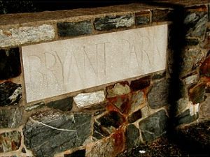
Bryant Park
1701 West Morehead Street
Charlotte, NC
Summary
Bryant Park, begun in 1930 and completed during the height of the Great Depression, is a property that possesses local historic significance as one of Charlotte’s first small-scale public parks, and as a tangible reminder of the early stages of the twentieth century push for public green space within the city. Although Latta Park, Charlotte’s first public park, was completed with much fanfare in the early 1890s, the concept of public recreational and natural green spaces gained acceptance slowly among city officials. Despite the creation of the Charlotte Park and Tree Commission in 1904, in the years between the turn of the century and the end of World War II the city’s parks system continued to rely on the staunch support of Charlotte-Mecklenburg’s private sector, rather than the support and funding of local government. Established on land donated by prominent developer E. C. Griffith, Bryant Park was one of the first projects of the Charlotte Park and Recreation Commission, which replaced the Charlotte Park and Tree Commission in 1927. Independence Park, Latta Park and Revolution Park, established in the years before the Great Depression, were large, sprawling expanses of carefully landscaped natural areas (Revolution Park encompassed over 240 acres), funded in large part by private funds and located outside of the center city area to service newly developed garden suburbs. The creation of Bryant Park in the early years of the Charlotte Park and Recreation Commission heralded a new kind of green space, the small neighborhood park, which would become extremely popular in the boom period after World War II. Although small and minimally landscaped, these parks would provide recreation space for the majority of Charlotte’s residents throughout the twentieth century.

Bryant Park is also significant as the earliest public park established within one of Charlotte’s most prolific industrial sectors, stretching along West Morehead Street. Serviced by a line of the Southern Railroad (which connected Charlotte to the nearby textile center of Gastonia) and connected to center city Charlotte by a newly constructed streetcar line, the area west of Charlotte’s central business district quickly developed into a thriving industrial district. Developers erected rows of working class houses in the Wilmore and Wesley Heights neighborhoods, and working class families flocked to west Charlotte in the early decades of the twentieth century. Bryant Park, located between Wesley Heights and Wilmore, provided west Charlotte residents with green space for a welcome respite from the noise of the factories and with specialized spaces (including a softball field, tennis courts, a volleyball court, and horseshoe pits) for a variety of recreational activities. Although the park has since lost many of these recreational amenities, Bryant Park, with its terraced hillside leading down to a wide expanse of green playing fields, and with its intricate and distinctive stonework, remains an important reminder of the evolution of green space within Charlotte’s urban landscape.Bryant Park’s development began in 1929-1930, but was stymied by the onset of the Great Depression, when public monies became scarce. The park’s construction, which primarily involved the construction of a complex configuration of stone boundary walls, terrace walls and stone seating for the large softball field, was completed during the height of the Great Depression, most likely with funding and labor provided by the Work’s Progress Administration, a federal government agency created by New Deal legislation to give local men and women needed jobs. Although the impact of New Deal work programs in Charlotte were most visible in the few large-scale projects like Memorial Stadium, Bryant Park reflects the influence of Federal programs on the neighborhood level.
Historical Background and Context Statement
The concept of public green space, although fully developed among academic circles and within northern cities by the end of the nineteenth century, did not gain widespread acceptance in New South cities like Charlotte until well into the twentieth century. In the mid-nineteenth century, cemeteries often served double duty as recreational green space, where residents and visitors could go to escape the noise and congestion of the city, and Charlotte continued to use their shady, quiet cemeteries as impromptu parks until the turn of the century . Charlotte had experienced unprecedented economic and physical growth in the last decades of the nineteenth century, yet “the amount of green space within the city . . . remained a constant: Settlers’ and Elmwood cemeteries.”1 Not surprisingly, Charlotte-Mecklenburg’s New South leaders, who had transformed Charlotte from a small farming community into a regionally important cotton trading and textile center, were among the first to grasp the importance of green space as an integral part of the city’s built environment. Entrepreneurs such as Edward Dilworth Latta, George Stephens, and Daniel Augustus Tompkins threw their support behind the concept of public green space by creating impressive, meticulously planned early examples of garden suburbs like Myers Park and Dilworth and neighborhood parks like Latta Park and Independence Park..
Initially, Charlotte seemed ready to embrace full-scale, long term city planning and the development and preservation of green spaces. Inspired by the success of Myers Park, the Charlotte Chamber of Commerce hired John Nolen, Myers Park’s designer, to conduct a civic survey and create a comprehensive city plan to control and direct future growth.2 Despite the city’s initial enthusiasm, Nolen’s ambitious plan for Charlotte’s growth, which included room for parks, lush garden suburbs and a scenic byway, was ultimately rejected by the Chamber, a decision which would affect the evolution of Charlotte-Mecklenburg’s green space for the rest of the century. Without financial support from the city and local government, green space developed only where sufficient private funds existed to pay for it. Not surprisingly, the first park established within the Charlotte area was created by businessman and developer Edward Dilworth Latta. Latta Park, completed in 1890, encompassed over seventy acres in the middle of the newly developed Dilworth neighborhood, but, with its large recreational lake and scenic walkways, it attracted people from all over Charlotte, and created interest in the possibility of green spaces within Charlotte’s center city communities.
Although interest in and demand for public parks grew significantly in the late nineteenth and early twentieth century, Charlotte’s government remained too small and unorganized to take on the responsibility of public green spaces. As historian Brian Sturm writes, Charlotte’s Board of Aldermen “refused to make parks a city priority because of the assumption that recreation was not the business of city government.”3 Once again, private interests came through to support the development of a formal government body devoted to establishing public parks and green spaces. D. A. Tompkins exerted his significant influence with the city, and lobbied tirelessly in favor of public parks in general and, specifically, the development of Independence Park, Charlotte’s first municipal park. Public parks, Tompkins argued, would bring upper and working classes together and were an important part of a productive work environment. “There are working people in our factories,” he told the Board, “who scarcely ever see the green grass, flowing water, and waving trees of the country. The park will afford them these with the few aides of nature we can put out there.”4 Tompkins succeeded, despite the apathetic nature of the board – in 1904, the Charlotte Park and Tree Commission was established, with Independence Park as the commission’s first project.5 After Independence Park’s completion, however, the activity of the Charlotte Park and Tree Commission practically ceased, due to lack of funding. Even with Tompkins serving as chair, the commission failed to create significant green spaces during the early decades of the twentieth century, despite the fact that Charlotte’s economy was booming and public buildings were being constructed at an unprecedented rate.6

In the late 1920s, E. C. Griffith, a prominent local developer and large center city landowner, donated 16 acres of land between the Wilmore and Wesley Heights neighborhoods in the rapidly developing industrial sector of west Charlotte to the Charlotte Park and Recreation Commission.7 The plot of land, named Bryant Park, was slated for development as a small neighborhood recreational center. Work began tentatively in 1930, but the onset of the Great Depression and subsequent shrinking budget forced the Charlotte Park and Recreation Commission to stop work on most of its projects, including Bryant Park.8The push for public green space entered its second stage in the year 1927, when the Charlotte Park and Tree Commission became the Charlotte Park and Recreation Commission. Although the new commission received funds through a small city tax, it remained financially unable to build new parks without the help of private funds. However, with several parcels of land, ranging from over 200 acres to less than ten acres, donated by wealthy local entrepreneurs, the commission began, slowly but surely, establishing parks in Charlotte. Most of these new parks, in contrast to Latta Park, Independence Park, and the recently completed Revolution Park, were mainly small parcels of land developed to serve specific neighborhoods. Bryant Park was among the first of these small neighborhood parks.
Despite the initial complications caused by the severe economic downturn of the late 1920s and early 1930s, the New Deal programs of the Roosevelt administration that came out of the Great Depression proved to be “a boon to parks and recreation” programs across the country. The Charlotte Park and Recreation Commission received Federal funds for a variety of projects, with most of the money and labor coming from the Works Progress Administration (later renamed the Works Projects Administration) and the Civilian Conservation Corps. Although only the biggest of Charlotte’s Federal parks projects, including Memorial Stadium and the city’s first municipal swimming pool, received widespread attention, a variety of small park projects that had been stalled by the economic slowdown were completed with the help of 1930s New Deal work programs. Bryant Park was most likely one of the small park projects to benefit from these Federal programs. The elaborate stonework seen throughout Bryant Park, which created seating for the park’s softball field and circled the perimeter of the park as a network of low walls, is nearly identical to the stonework used in W.P.A. projects across North Carolina, including the stonework in nearby Independence Park, which was completed in part through Federal funding during the 1930s.9 Moreover, the park was completed by the early 1940s, before the 1949 bond initiative that promised to create “a playground within a half-mile of every home” in Charlotte-Mecklenburg, and well before the 1950s boom period for parkland acquisition.10 As one of the earliest small public parks completed in Charlotte, Bryant Park was a model for the dozens of neighborhood parks constructed in the post-war period, and, with its softball field, volleyball and tennis courts, and horseshoe pits, it served as a recreational center for the surrounding Wesley Heights and nearby Wilmore neighborhoods. However, as the Charlotte Mecklenburg Park and Recreation Commission suffered from ongoing lack of funding in the 1960s and 1970s, and as more and more industrial development crowded along the main artery of West Morehead Street in the last half of the twentieth century, Bryant Park lost many of its original recreational spaces. The park today has retained only 6.6 of its original 16 acres, and the only designated recreational space that remains is the centerpiece of Bryant Park, the softball field.

Bryant Park, set among the dense clustering of low brick industrial buildings that line West Morehead Street, is also locally significant as the earliest public park established within one of Charlotte’s most prolific industrial sectors, stretching along West Morehead Street. Serviced by a line of the Southern Railroad (which connected Charlotte to the nearby textile center of Gastonia) and connected to center city Charlotte by a newly constructed streetcar line, the area west of Charlotte’s central business district quickly developed into a thriving industrial district. Prominent businesses such as the Grinnell Company and the Coca-Cola Company built their plants along West Morehead Street Developers such as F. C. Abbott erected rows of working class houses in the Wilmore and Wesley Heights neighborhoods, and working class families flocked to west Charlotte to work and live in the early decades of the twentieth century.11 The construction of Bryant Park in the 1930s reflected the increasing importance of these west Charlotte working class neighborhoods and the industrial economy they supported.Physical Description and Site Context
Bryant Park comprises 6.6 acres of terraced hillside and flat playing field, bound on the north by West Morehead Street, on the west by Suttle Avenue, and on the east by a small creek bed. The main entrance to the park is located on the south end of the property, on the park’s highest elevation, and leads to the most impressive feature of the park – the stone seating for the park’s only remaining recreational space, the softball field. A complex network of steps, walls of varying heights, and wide benches are arranged organically into the steeply sloping hillside, and, from a distance, seem almost to be a natural outcropping. The stone bleachers, like the retaining walls along the terraced hill south of the softball field and the low walls and entrance that line the north side of the park, along West Morehead Street, are made of a thick layer of common stone and rubble faced with more finished granite stones. A shady, steeply sloped area to the west of the softball field is dotted with benches and mature trees. The hilly area and the softball field on the southern end of the park give way to a broad, uninterrupted expanse of green lawn, which stretches north to West Morehead Street. As the only green space located within the industrial sector of west Charlotte, which once provided the residents Wilmore and Wesley Heights with a welcome respite from the noise of the factories and with specialized spaces (including a softball field, tennis courts, a volleyball court, and horseshoe pits) for a variety of recreational activities, and as one of the earliest public parks completed in Charlotte, Bryant Park remains an integral part of the city’s built environment and a visual reminder of the evolution of green space within Charlotte’s urban landscape.
_________________________________
1. Brian W. C. Sturm, “The Evolution of Green Space: A History of Urban Landscape in Charlotte, North Carolina, 1890-1990” (honors thesis, University of North Carolina at Chapel Hill, 2000), 1-2.
2. Thomas W. Hanchett, “Charlotte’s Neighborhood Planning Tradition,” (Charlotte-Mecklenburg Historic Landmarks Commission, 1986), 3.
3. Sturm, 21.
4. The Charlotte Observer, August 2, 1904.
5. The Charlotte Observer, November 8, 1904 and Jun 6, 1905.
6. Ibid.
7. Legette Blythe and Charles R. Brockmann, Hornet’s Nest: The Story of Charlotte and Mecklenburg County (Charlotte, 1961).
8. The Charlotte Observer, February 28, 1950.
9. J. S. Curt, W. A. Cutter, and Thomas Morse, Emergency Relief in North Carolina: A Record of the Development and Activities of the North Carolina Emergency Relief Administration (Raleigh, 1936).
10. Sturm. Clippings from file labeled “Parks and Recreation,” located in the Vertical files of the Robinson Spangler North Carolina Room of the Charlotte Mecklenburg Public Library.
11. Dr. Dan L. Morrill, “Survey and Research Report on the Electric Supply and Equipment Company” (Charlotte Mecklenburg Historic Landmarks Commission).