Charlotte-Mecklenburg Historic Landmarks Commission

Author: Mary Dominick

Settlers’ Cemetery (Old)

This report was written on January 3, 1984

1. Name and location of the property: The property known as the Old Settlers’ Cemetery is located on West Fifth Street, between Poplar and Church Streets, in Charlotte, North Carolina.

2. Name, address, and telephone number of the present owner and occupant of the property: The present owners of the property are:

City of Charlotte
600 East Trade Street
Charlotte, N.C. 28202

Telephone: (704) 374-2241

3. Representative photographs of the property: This report contains representative photographs of the property.

4. A map depicting the location of the property: which depicts the location of the property. This report contains a map depicting the location of the property.

5. Current Deed Book Reference to the property: The Register of Deeds office contains no individual Deed to this property. The Tax Parcel Number is 078-012-01.

6. A brief historical sketch of the property: This report contains a brief historical sketch of the property prepared by Dr. William H. Huffman.

7. A brief architectural description of the property: This report contains an architectural description of the property prepared by Thomas W. Hanchett.

8. Documentation of why and in what ways the property meets the criteria set forth in N.C.G.S. 160A-399.4:


a. Special significance in terms of its history, architecture, and/or cultural importance: The Commission judges that the property known as the Old Settlers’ Cemetery does possess special significance in terms of Charlotte-Mecklenburg. The Commission bases its judgment on the following considerations: 1) the Old Settlers’ Cemetery was the first municipal burial ground in Charlotte, North Carolina and functioned in this capacity from 1776 until 1867, 2) the Old Settlers’ Cemetery contains the earthly remains of many of the most prominent citizens of Charlotte and Mecklenburg County in the late 18th and 19th century, and 3) the Old Settlers’ Cemetery forms the centerpiece of the Fourth Ward Historic District.

b. Integrity of design, setting, workmanship, materials, feeling and/or association: The Commission contends that the attached architectural description by Thomas W. Hanchett demonstrates that the Old Settlers’ Cemetery meets this criterion.

9. Ad Valorem Tax Appraisal: The Commission is aware that designation would allow the owner to apply for an automatic deferral of 50% of the Ad Valorem taxes on all or any portion of the property which becomes “historic property.” The subject property is owned by the City of Charlotte and is therefore, exempt from Ad Valorem Taxes.

Date of preparation of this report: January 3, 1984

Prepared by: Dr. Dan L. Morrill, Director
Charlotte-Mecklenburg Historic Properties Commission
1225 S. Caldwell Street
Charlotte, North Carolina 28203

Telephone: (704) 376-9115


Historical Overview
 

Dr. William H. Huffman

Sitting on part of the hilltop that comprises the heart of Charlotte, just two short blocks from the Square, is the city’s oldest cemetery. Now as much a pleasant inner-city park as a cemetery, it shares the block bounded by 5th, Poplar, 6th and Church Streets with a modern condominium building and the old North Carolina Medical College. Since it is just to the East across 5th Street and from the venerable First Presbyterian Church, it has been assumed by many to be, or to have been, a cemetery connected with the church. Indeed, one of its old popular names was “The Presbyterian Burying Ground,” but, as it turns out, this was never the case, even though it was a reasonable assumption.

The history of the church and the cemetery were intimately linked, however, in the early days of the Queen City. The town itself was established in 1768, the year following the purchase of 360 acres of land from George Augustus Selwyn (1719-1791) for that purpose by the town commissioners. Selwyn had inherited a 100,000-acre tract in 1751 from his father, Colonel John Selwyn, Esquire, an English country gentleman who had been granted the parcel from George II in 1745 for services rendered to the crown. In the 1760s, the younger Selwyn, through agents in North Carolina, began to sell off tracts, mostly plantations of 200 to 500 acres along the creeks and rivers.

Apparently the present sites of the First Presbyterian Church and the cemetery were both used for religious worship and burials, respectively, not too long after the formation of the town. It was not until 1815, however, that those two locations were officially set aside exclusively for their traditional purposes by the city. The Town Church, as it was originally known, was constructed from 1818 to 1823, and was intended for use by all denominations, but because of their greater numbers, was used mostly by the Presbyterians. Similarly, the cemetery was the only nondenominational one in town, but would have naturally contained more Presbyterians than others. Thus the name, “The Presbyterian Burying Ground,” was not totally inaccurate, even though it was not an official church cemetery. In 1835, the First Presbyterian Church did acquire the Trade Street site for its exclusive use, but this did not include the old cemetery.

The oldest known burial in the Old Cemetery is that of Joel Baldwin, who died October 21, 1776, at the age of 26, and, although the site was closed in 1867, burials with special permission took place until 1884. During that time, many of Charlotte’s families, from the best-known to the least, were laid to rest there, including veterans of the Revolutionary and Civil Wars. A good number of them were the founding pioneers of Charlotte and Mecklenburg County. The northwest corner of the cemetery was set aside for the servants of the families whose members were interred there.

One of the figures from the Revolutionary era there is Colonel Thomas Polk, who died in 1793, and was the great-uncle of President James K. Polk. Among his accomplishments were reported to be his holding office as one of the county’s first commissioners, being treasurer and trustee of Queens College and a member of the Colonial Assembly, and signing the Mecklenburg Declaration of Independence. Next to him is his wife, Susannah Spratt Polk, whose father’s house, that of Thomas Spratt, was the site of the first court held in Mecklenburg County.

A hero of the Revolutionary War, Major General George Graham (1758-1826) is also interred in the Old Settlers’ Cemetery. Graham came to Charlotte in 1764 from Pennsylvania, and was at the historic battle at McIntire’s farm where a small group of patriots sent a detachment of 600 British soldiers back to Cornwallis with the complaint that there was a “rebel behind every bush.”

Another interesting figure from the early era to be found in the hilltop graveyard is Dr. Nathaniel Alexander (1756-1808). Alexander was born in what later became Mecklenburg County, graduated from Princeton in 1776, and was commissioned a surgeon in the North Carolina Regiment of the Continental Line, where he served for four years. He practiced medicine for a time in South Carolina, then moved to Charlotte, where he eventually entered politics. After serving in the state House and Senate, he became a Member of Congress from 1803 to 1805. When Governor Turner resigned in the latter year to fill a vacancy for the United States Senate, Dr. Alexander became the North Carolina governor, and served to 1807. He married the daughter of Colonel Thomas Polk, mentioned above, Margaret Polk Alexander (1758-1800).

An impressive obelisk monument in the cemetery contains the name of William Davidson (1778-1857), one of several with that well-known Mecklenburg name there. Davidson moved to the county as a youth, where he became a planter, and subsequently entered politics. He was a member of the state Senate in 1813, 1815-19, and 1825. After moving to Charlotte in 1820, he was elected to the 15th Congress as a Federalist to fill a vacancy, and was re-elected to the 16th Congress, serving from December, 1818, to March, 1821. After an unsuccessful run for the 17th Congress, he was again elected to the state Senate, serving from 1827 to 1830.

Some Confederate veterans were also buried in Old Settlers’. One of the remaining monuments is that of Colonel William Allison Owens, of the 53rd Regiment, N.C.T., who was born September 19, 1833, and was wounded at Snickers Gap, Virginia, on July 18, 1864, and died the following day. Owens’ obelisk monument still has the distinctive iron cross marker of the United Daughters of the Confederacy in front of it, apparently the last one extant in the cemetery. Another Confederate monument was to mark the memory of Lieutenant Joseph Davidson Blake of the Confederate Navy Yard in Charlotte.


United Daughters of the Confederacy marker
In 1855, Elmwood cemetery, then known as the New Cemetery, was opened and accommodated its first burial. Its opening was necessitated by Old Settlers’ reaching capacity, and on April 29, 1867, after taking in some Confederate veterans of the leading families, the city passed an ordinance closing it, which read in part, “…that the Board having opened the new Cemetery for burial purposes, now deem it expedient to forbid the interment of dead bodies in the old Grave Yard of the city, from and after the 1st day of August next….Any person violating this ordinance shall forfeit and pay $25 for each offence….”

Forty years after its closing, the cemetery was suffering from some neglect. In 1906, the Charlotte Park and Tree Commission, with Daniel Augustus Tompkins, the noted industrialist as president, and George Stephens, the developer of Myers Park as secretary-treasurer, jointly undertook the preservation and beautification of the cemetery with the D.A.R. Auxiliary Committee for Cemetery Square. This project produced one of the unique historical features of the cemetery, the iron gate and the granite gateposts on 5th Street, which used to be the entrance.

The gate was ordered in 1842 by James Harvey Orr, at his wife’s request, for their home on South Tryon Street near the old First National Bank. It was handmade at the Vesuvius Furnace in Lincoln County, which was owned by Orr’s father-in-law, John D. Graham, whose grandfather, General Joseph Graham, had built the forge in 1791. The gate decorated two of the Orr’s homes in Charlotte, but was removed when the second home was sold to Dr. Charles L. Alexander and demolished. A relative, Julia Alexander, who was a member of the D.A.R. committee, acquired the gate from Dr. Alexander and the two granite posts from her father, S. B. Alexander. The posts were from the home of her paternal grandmother, Violet Graham Alexander, the daughter of General Joseph Graham.

After the 1906 campaign, the historic hilltop cemetery remained a showplace for a number of years, but eventually the decades took their toll, and, after the passage of another forty-five years, once again it was in need of attention. Oddly enough, the main reason why city beautification programs were not undertaken until the early 1950s is that over the years knowledge of the ownership of the land was lost, thus thwarting all efforts. During all those years, the D.A.R. Committee, including Julia Alexander, and a few relatives, attempted to care for the cemetery themselves, sometimes hiring a landscape gardener to do the work. In the spring of 1952, Julia Alexander “personally paid to have the tombstones and monuments needing repair repaired by an outstanding marble firm of the city with the exception of one monument reset and paid for by a relative.” The D.A.R., in 1925, had also planted an oak tree to commemorate the visit of George Washington to Charlotte in 1791, and in 1932 put a bronze tablet by the tree to mark the 200th anniversary of Washington’s birth.

Still, the Old Cemetery was showing signs of age, and it got a boost under the administration of Charlotte Mayor Victor Shaw (served 1949-1953), who took a personal interest in the cemetery and made its renovation a top priority of his term of office. The first order of business was to determine ownership of the property, which was discovered to be that of the city. Mayor Shaw then persuaded the City Council to spend over $10,000 to do landscaping, lay cement walkways, install electric lights and put in a fountain. The beautification project was completed in early 1953, and the following year stone benches with wood seats were also installed.

By the mid-Sixties, however, the cemetery found itself once again in poor condition from the effects of time, vandalism and vagrants. In 1968, as part of an urban beautification program for the whole city totaling $195,000 ($102,000 supplied by the city, the rest from a federal grant), the city decided to spend $40,000 to restore the Old Cemetery and further make it into an attractive inner-city park. $22,000 was spent on new landscaping, new brick walkways and benches were installed, a three-tiered fountain with colored lights was constructed in the southeast corner, and the monuments were cleaned, all of which gave the cemetery its present-day look and reclaimed it as an attractive part of downtown Charlotte.

Whether it is called the “Presbyterian Burying Ground,” the “Old Cemetery,” or “Old Settlers’ Cemetery,” there is no question about the great historical importance of Charlotte’s first public burial ground. In it rests many members of Charlotte and Mecklenburg County’s founding families: Alexander, Davidson, Graham, Polk, Orr, Berryhill, Owens, Asbury, Hoskins, Springs and a number of others, to name a few. Some were government leaders, some pioneer industrialists and entrepreneurs, others were soldiers in the Revolutionary and Civil Wars, but all of them played a significant role in the establishment of the civil and economic life of the city and county. The site itself has always played, and continues to do so, a distinctive role in the features of the heart of the city of Charlotte.


NOTES

1 William H. Huffman, “A Historical Report on Reedy Creek Park,” May, 1981, p. 1.

2 Charlotte Observer, March 26, 1939, Sec. 3, p.6.

3 Ibid.; Elizabeth Williams, First Presbyterian Church, 2 vols. (Charlotte).

4 See note 2.

5 Biographical Directory of the American Congress, 1774-1971 (U. S. Government Printing Office, 1971) p. 194.

6 Ibid., p. 829.

7 Monuments in Old Settlers’ Cemetery.

8 The Western Democrat, April 30, 1867, p. 3.

9 Letter from Charlotte Park and Tree Commission to Mr. Davidson, dated 18 February 1906.

10 See note 2.

11 Letter from Julia Alexander to the Mecklenburg Times dated 16 March 1953, printed 19 March 1953.

12 See note 2.

13 Charlotte Observer, December 10, 1952, p. l; Mecklenburg Times, September 2, 1954, p. 1.

14 Charlotte News, May 18, 1965, p. 1C; Charlotte Observer, December 31, 1968, p.l8; Ibid., January 18, 1969, p.l8.; Ibid., August 22, 1969, p.l8.


Architectural Description
 

Thomas W. Hanchett

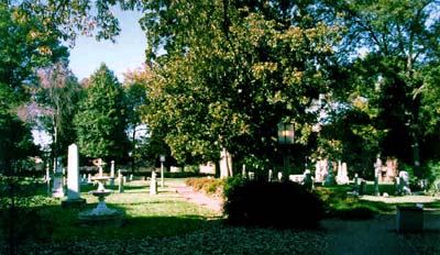
For more than two centuries Settlers’ Cemetery has been an important public space in the heart of downtown Charlotte. It occupies nearly a full block of prime center city land, bounded on three sides by Fifth Street, Church Street, and Poplar Street, and on the fourth side by a strip of private building lots facing Sixth Street. Though it has undergone many changes through long-term neglect and periodic attempts at beautification, its ancient stones remain an important tangible link to Charlotte’s early history.

Settlers’ Cemetery commands a hillside site, which afforded early visitors a pleasant view north to the hill beyond Briar Creek. Today the largest number of gravestones may be found in the south quadrant, near Church and Fifth streets, which was the highest part of the cemetery. The north quadrant, at the bottom of the hill, is said to have been the burying place for slaves and servants, and no markers survive in the lower part of this area.

Gravestones are not set in rigid rows, but rather form small family groups. All burials were evidently oriented the same way, however, with feet to the east and head to the west, providing a loose sort of visual order in the graveyard. The orientation of the graves clashes with the orientation of the cemetery itself: Charlotte’s 1768 street grid was not aligned with the compass points but rather angled to correspond with the two original Indian trading paths, Trade and Tryon streets.

In 1983 most surviving markers date from the 1840s, 1850s, and 1860s. Settlers’ Cemetery functioned as Charlotte’s main burial ground from at least the 1770s into the 1860s. Though superseded by the 1855 Elmwood cemetery a few blocks away, Settlers’ continued to receive occasional new graves into the 1880s.

Markers are primarily simple tablets, with a scattering of small obelisks, and a number of raised individual crypts featuring either vertical or horizontal tablets. There is little of the ornate statuary and none of the elaborate mausoleums found in Elmwood. This may be in part due to the passage of time, such stones being especially attractive to the vandals and thieves who have obviously been quite active in Settlers’ Cemetery. More likely, it is a true expression of both the limited means and simple tastes of the residents of antebellum Piedmont North Carolina.

Marble was the most common material for markers, with a scattering of limestone and a blackish, quartz-laden stone that resembles soft granite. The earliest stones, dating from the 1770s into the 1810s, are of this material, and their inscriptions are among the cemetery’s most readable. A single Charlotte stone-mason likely carved them all, for they share the same Gothic lettering and awkward spacing that frequently saw the carver disregard right margins and continue words around to the side of the stone. By the mid-nineteenth century, several stone-carvers were at work, and Settlers’ Cemetery boasts numerous signed examples of their art. J.W. McCoy may have been the first to sign his handiwork, in 1813. By the 1860s, “Hoot,” F.A. McNinch, “Tiddy,” and W.T. White had joined him. White was the most prolific, with at least seven surviving markers to his credit. There may be more, for the marble frequently used has eroded to unreadability over the years on many stones.

Several markers are worth individual note. Four of the earliest stones, dating from the 1770s, were dug up during construction of the Mercy Hospital Nurses Residence in the Elizabeth neighborhood and moved to Settlers’ Cemetery as part of Mayor Victor Shaw’s 1953 beautification efforts. The most elaborate of the raised crypts is a double tomb for John and Mary Irwin, which has Gothic blind arches decorating its sides. A cast iron fountain, apparently of Victorian design with water from a central jet cascading down a series of fluted bowls, decorates the north corner of the cemetery. A heavy iron gate between two stone piers, made for a private residence in 1842 and moved to the cemetery in 1906, guards the main entrance on Fifth Street.

Settlers’ Cemetery has always been owned by the city, and has gone through several cycles of neglect and renewal. The first beautification efforts in 1906 were directed by planner and landscape architect John Nolen. The work was one of the first projects in the career of this nationally significant designer, who went on to execute over 400 projects nationwide, and take a leading role in the founding of planning’s first professional organizations. No drawings of “Cemetery Square,” as his project was known, survive in Nolen’s professional papers at Cornell University. It is likely that many of the cemetery’s trees follow Nolen’s suggestions. They are scattered without formal pattern to achieve the sort of naturalistic effect that he admired, and include a variety of species, among them oak, pine, magnolia, and nandina.

The next flurry of beautification work came in the early 1950s. None of the concrete walks or stone and wood benches installed at this time remain in 1983, but there is ample evidence of reset and repaired monuments funded by philanthropist Julia Alexander. The most recent work dates from 1968, and is somewhat heavy-handed. Brick walkways loop through the block, focusing on an oversized circular fountain and seating area in the east corner of the cemetery overlooking Church Street. Planting beds and shrubbery lining the walks were placed without regard to the stones, leaving several tombs in the midst of dense bushes. Nonetheless, the new landscaping reinforces the park-like nature of the cemetery, which has been an important aspect of its existence since the beginning, and helps to make Settlers’ Cemetery a frequently-used open space in today’s city.


This report was written on September 5, 1979

1. Name and location of the property: The property known as the Seaboard Air Line Railroad Passenger Terminal is located at 1000 N. Tryon St. in Charlotte, N. C.

2. Name, address and telephone number of the present owner and occupant of the property: The present owner of the property is:

The Seaboard Coast Line Railroad Co.
3600 W. Broad St.
Richmond, Va. 23219

Telephone: (804) 359 6911

3. Representative photographs of the property: This report contains representative photographs of the property.

4. A map depicting the location of the property: This report contains a map depicting the location of the property.

5. Current Deed Book Reference to the property: The most recent deed on this property is recorded in Mecklenburg County Deed Book 7 at Page 232. There is no individual Tax Parcel Number assigned to this property.

6. A brief historical sketch of the property:

The initial railroad passenger terminal on this site was built in 1858 by the Wilmington, Charlotte and Rutherfordton Railroad Company. 1 It served as the eastern terminus of a thirty one mile line from Charlotte to Lincolnton, which was completed by April 1861. On May 17, 1873, the Carolina Central Railroad Company acquired the right of way and undertook the task of completing a continuous track from Wilmington, N.C., to Rutherfordton, N.C. This job was completed on December 15, 1874. The terminal on N. Tryon St. now provided access to the major east-west passenger line in Charlotte. On August 1, 1893, the Carolina Central joined with several other railroads in forming the Seaboard Air Line. 2 Soon thereafter, major improvements were performed at the Charlotte terminal. A ticket office and waiting rooms were added. 3

The initial passenger terminal, a narrow two story structure with a tin roof, was destroyed by fire on the night of February 11, 1895. 4 As a temporary measure, the Seaboard Airline enclosed the passenger sheds for use as an interim facility. 5 From the outset, the company planned to build a new and more imposing edifice. “The arrangements at the depot at present do well enough for summer”, The Charlotte Observer reported, “but for winter quarters are no good.” 6 On July 28, 1895, the local press announced that the architect of the new terminal would be Charles Christian Hook. 7

C. C. Hook (1870-1938) was the first architect to live in Charlotte, N.C. A native of Wheeling, WV, and graduate of Washington University, he moved to this community in 1891 to teach in the Charlotte Graded School, which was located at the corner of South Blvd. and E. Morehead St. 8 Most of his early commissions were for structures in Dilworth, the streetcar suburb which the Charlotte Consolidated Construction Company, locally known as the Four C’s, opened on May 20, 1891. 9 Among the significant edifices which he designed during his career were the Charlotte City Hall, the clubhouse of the Charlotte Woman’s Club and White Oaks or the James B. Duke Mansion on Hermitage Rd. 10 Indeed, C. C. Hook occupied a place of preeminent importance in the architectural history of Charlotte.

Construction of the new passenger depot began in December 1895. 11 The Seaboard Air Line opened the terminal on June 16, 1896. 12 It was a two story brick structure, 40 feet wide and 120 feet long. 13 The Charlotte Observer commented upon the opening of the facility.


The new building is two stories high, is of brick and altogether a credit to the road and City. 14

The terminal was built by W. C. Williams, a local contractor. 15

One of the most dramatic events associated with the Seaboard Air Line Passenger Station occurred on May 2, 1898. A throng of local citizens gathered there to bid farewell to approximately two hundred men who were departing for service in the Spanish American War. A procession, headed by Confederate veterans, marched from Independence Square to the terminal through a “solid phalanx of humanity.” “Yards and houses were decorated with flags, and from thousands of throats went up cheer after cheer”, The Charlotte Observer reported. When the train arrived from Shelby, N.C., the Charlotte troops, belonging to either the Hornets’ Nest Rifles or the Queen City Guards, fired a howitzer in salute to the soldiers aboard. The Charlotte Observer was expansive in describing what followed.


…farewells were said, and the soldiers boarded the train, many of them laden with flowers. Tears fell from the eyes of mothers, sisters and sweethearts. To them it was a sad occasion. 16

A major renovation of the Seaboard Air Line Passenger Terminal occurred in 1916-17. A building permit for the project was issued on August 7, 1916, and the station opened on January 31, 1917. Plans for the renovated structure were prepared by Seaboard officials. A. M. Walkup, Inc., of Richmond, Va., erected the edifice. It is important to note that Hook’s 1896 terminal constituted the mayor portion of the new station. The cost of the renovation and enlargement of the Charlotte terminal was $22,000. 17

The advent of the “automobile era” eroded the popularity of trains as a means of inter-city transportation. The last train from Charlotte to Rutherfordton departed in December 1950. The final train traveling eastward left the station on November 3, 1958. Thereafter, the structure served as a yard office for the Seaboard Air Line, later Seaboard Coast Line Railroad. It continues in that capacity. 18


Footnotes

1 “Charlotte. Railroads Seaboard, a folder in the vertical files of the Carolina Room of the Charlotte Mecklenburg Public Library. Hereafter cited as Seaboard. Daily Charlotte Observer (February 12, 1895), p. 4. The term “The Charlotte Observer” this report, although the newspaper appeared under various titles.

2 Seaboard.

3 Daily Charlotte Observer (February 12, 1895), p. 4.

4 Ibid.

5 Daily Charlotte Observer (February 14, 1895), p. 4.

6 Daily Charlotte Observer (November 23, 1895), p. 4.

7 Daily Charlotte Observer (July 28, 1895), p. 6.

8 The Charlotte News (September 17, 1938), p. 12.

9 The Charlotte News (May 20, 1891), p. 1.

10 Jack O. Boyte & Dr. Dan L. Morrill, “Survey and Research Report on Lynnwood for the Charlotte Mecklenburg Historic Properties Commission”. (January 5, 1977); Jack O. Boyte & Dr. Dan L. Morrill, “Survey and Research Report on the Mecklenburg County Courthouse for the Charlotte Mecklenburg Historic Properties Commission”, (April 5, 1977); Ruth Little-Stokes & Dr. Dan L. Morrill, “Survey and Research Report on the Clubhouse of the Charlotte Woman’s Club”, (April 1, 1978).

11 Daily Charlotte Observer (Nov. 23, 1895), p. 4; January 1, 1896), p. 1.

12 Daily Charlotte Observer (June 17, 1896), p. 1.

13 Daily Charlotte Observer (July 28, 1895), p. 6.

14 Daily Charlotte Observer (June 17, 1896), p. 1.

15 Daily Charlotte Observer (March 12, 1896), p.4.

16 Daily Charlotte Observer (May 3, 1898), p. 6.

17 Sally McMillen, “The Seaboard Passenger Station”, an unpublished manuscript in the vertical files of the Charlotte Mecklenburg Public Library, more specifically in the Carolina Room.

18 Seaboard.


7. A brief architectural description of the property: This report contains an architectural description of the property prepared by Caroline Mesrobian, architectural historian.

8. Documentation of way and in what ways the property meets the criteria set forth in NCGS 160A-399.4:


a. Special significance in terms of its history, architecture, and/or cultural importance: The Commission judges that the property known as the Seaboard Air Line Railroad Passenger Terminal does possess special historic significance in terms of Charlotte Mecklenburg. The Commission bases its judgment on the following considerations: 1) it is the only pre 1900 railroad passenger terminal which survives in Charlotte, N.C. and 2) the original portions of the building were designed by C. C. Hook, Charlotte’s first architect.

b. Integrity of design, setting, workmanship, materials, feeling and/or association: The Commission judges that the architectural description included herein demonstrates that the property known as the Seaboard Air Line Railroad Passenger Terminal meets this criterion. Indeed, the 1916 terminal is essentially intact, except for extensive renovations on the first floor of the terminal.

9. Ad Valorem Tax Appraisal: The Commission is aware that designation would allow the owner to apply for an automatic deferral of 50% of the Ad Valorem taxes on all or any portion of the property which becomes historic property. The Seaboard Air Line Railroad Passenger Terminal is not listed individually in the records of the Mecklenburg County Tax Office. Consequently, it is impossible to determine therefrom the Ad Valorem tax appraisal on this parcel.


Bibliography

Jack O. Boyte & Dr. Dan L. Morrill, “Survey and Research Report on Lynnwood for the Charlotte Mecklenburg Historic Properties Commission.” (January 5, 1977).

Jack O. Boyte & Dr. Dan L. Morrill, “Survey and Research Report on the Mecklenburg County Courthouse for the Charlotte Mecklenburg Historic Properties Commission ” (April 5, 1977).

The Charlotte News.

“Charlotte. Railroads Seaboard”, a folder in the vertical files of the Carolina Room of the Charlotte Mecklenburg Public library.

Daily Charlotte Observer.

Ruth Little Stokes & Dr. Dan L. Morrill, “Survey and Research Report on the Clubhouse of the Charlotte Woman’s Club”, (April 1, 1978).

Sally McMillen, “The Seaboard Passenger Station,” an unpublished manuscript in the vertical files of the Carolina Room of the Charlotte Mecklenburg Public Library.

Records of the Mecklenburg County Register of Deeds Office.

Records of the Mecklenburg County Tax Office.


Date of Preparation of this Report: September 5, 1979.

Prepared by: Dr. Dan L. Morrill, Director
Charlotte Mecklenburg Historic Properties Commission
139 Middleton Dr.
Charlotte, N.C. 28207

Telephone: (704) 332 2726


Special Note: For a photograph of the 1896 terminal, see Sketches of Charlotte No. 3 (Wade H. Harris Publisher, Charlotte, N. C., 1899), p. 14. A copy is located in the Carolina Room of the Charlotte Mecklenburg Public Library.


Architectural Description
 

The Seaboard Passenger Station, located at 1000 North Tryon Street, stands on the cul de sac of East 13th Street. The depot’s northeast facade faces the railroad tracks, while its northwest side overlooks Tryon Street The southwest side is bounded by the termination of East 13th Street and a concrete retaining wall erected in 1917; the southeast facade overlooks the street and an ample parking area.

The two story, pink stucco station is characterized by a continuous umbrella shed which, in addition, extends along the tracks 59 feet from the end of the building on the north west side, and 104 feet on the southeast side. A sign bearing the words “Charlotte, N.C.” is attached to the southeast extension facing the entrance to the yard.

Examination of the station shows there have been two distinct building periods of the present edifice; the central two story portion being constructed first, with the one story additions on the northwest and southeast sides being erected at a later period. Newspaper accounts in 1895 relate that an enclosed shed was to be replaced by a two story building, 40 feet by 120 feet, and set about 35 feet from the tracks. The architect was Charles C. Hook. l The brick structure with trimmings of brown stone was occupied on June 16, 1896. 2

The Sanborn Insurance Map of 1900 shows a rectangular building, its northeast side having contained a bayed area placed northwest of the center of that facade. A rectangular projection on the southeast facade corresponded in placement to the bay on the northeast facade, while another rectangular area projected from the central portion of the northwest side. A wide shed extended around all sides excepting the southeast; the southwest gallery also contained a centrally located porte cochere.

A small photograph 3 showing men boarding the Seaboard Air Line for the Spanish American War in 1898 includes a view of the southeast side of the station. The depot consisted of a two story building with a one story structure extending from the southeast end. Both structures were of brick and had slate tripped roofs. Each facade contained two bays with rectangular double hung 1/1 windows forming both the exposed upper story of the main building and the one story section. The porte cochere extending from the southwest facade was also present. The Sanborn Insurance Map could not show, however, that the polygonal bay on the northeast side was turreted, a typical Victorian feature. A slight projection of the roofline on the southwest side indicates that the rectangular projection also had its own roof. Correspondingly, the northwest facade may have had a similar arrangement.

The Sanborn Insurance Map shows that the main floor was devoted to two waiting rooms with a ticket office located in between them; the baggage room was on the southeast end of the depot. Newspaper accounts describe the plans for the 1895-96 depot. The waiting room on the Tryon Street was for Whites; its dimensions being 27 by 29 feet. The ladies’ toilet room opened onto it from the west side, facing Tryon Street. A hallway and the ticket office were located in the center of the building between the White and Colored waiting rooms, the latter being 16 by 27 feet, on the east side of the ticket office, and it also contains toilet facilities. The baggage room, 12 by 27 feet, was adjacent to the Colored waiting room. A staircase located in the hall in the center of the station rose to a hall of similar dimensions to the first floor. Rooms on this floor were largely for the railroad’s use: an office and engineers’ dormitory, each 15 by 28 feet; conductors’ and train master’s rooms, each 15 by 12 feet; telegraph room, 13 by 15 feet; and convenience areas.

Discussion of the proposed enlargement and remodeling of the station began in January 1916. The plans were drafted by Seaboard architects in the main office in Norfolk, Virginia. Contracting was awarded to the A. M. Walkup Company of Richmond, Virginia;: two oval metal plaques on the northeast side of the depot bear the inscription “A. M. Walkup, Richmond, Va. 1916.” Newspaper accounts related that the side walls of the present station were to be retained and employed in the remodeling. The end walls were to be torn out and the building extended. When the passenger station officially reopened on January 31, 1917, a temporary depot structure adjacent to Tryon Street was demolished.

Comparison of elevations for the remodeling (dated May 18, 1916) and the present station shows relatively little alteration. The track facade (northeast) is characterized by an unsymmetrical arrangement of fenestration and entranceways which reflects the various functions of the interior spaces. The central (original) section contains five bays. On the lower story the southern most bay contains a pair of rectangular windows with double hung sashes 1/1. All station windows have smooth stucco frames. The next bay contains an entrance to a waiting room with double doors each door bearing a rectangular plate of glass set in wooden frame. The doors are flanked by narrow, rectangular side lights with wooden paneling below. A transom with side lights comprises the upper section of the entrance. Sills are of granite. All entrances appear to have had screen doors at one time. A polygonal projecting bay, centrally located in this section of the facade, consists of three double hung 1/1 rectangular windows. The next bay contains a pair of double hung 1/1 windows, while the other waiting room entrance, identical to the previously mentioned entrance, marks the northernmost bay of this central section.

The second story contains the continuation of the central located bay with three double hung 1/1 windows. The 1896 turret is no longer extant. This projection is flanked on either side by two pairs of the same type windows. The original quoining in the 1896 section remains only on the second story, the lower corners having been removed.

The 1917 extensions to the two story central section are one story. It appears that the 1896 baggage room was demolished to make room for the southern oriented addition, its track side facade having two bays. The end bay contains the entrance to the baggage and freight area. Its door has been altered and was originally a double door with a two sectioned transom. The other bay is pierced by a square transom window placed relatively high in the wall, At this point there is a break in the wall indicating the transition from the original building to the annex. The north addition also contains two bays, they being formed by two pairs of windows with double hung sash, 1/1.

A 3′ 11″ dark red tapestry brick veneer runs around the facade as well as the other sides of the station. This brickwork was not an original feature of the 1896 structure and was added during the remodeling most likely to unify the sections of the station and to protect the pink stucco walls. The veneer’s base is formed by stretchers placed on their ends, the middle section with rows of stretchers and the top with a border of two headers. The topmost headers were molded so as to join smoothly with the walls. The entire facade is finished with kellastone (pebble dash) granite stucco over a brick base. Quoining with a smooth kellastone finish was employed for the corners of the two extensions,and extends down to the brick veneer. Metal guards painted green protect all lower corners of the station.

The roofs of the central section and the extensions are tripped, have wide eaves, and are of red transite asbestos shingles laid in a diamond pattern. Roof edges are covered with pieces of turned terra cotta. The original roof had been of slate.

The most striking feature of this facade and the other side of the station is the wide umbrella shed; its structure is identical on all sides excepting the southwest. The shed is a continuation of the roofs of the 1917 extensions and projects from an area between the original building’s first and second stories, The 1917 elevation shows that asbestos shingles were to be employed and that two skylights (10 by 13 feet) were to be inserted in the shed at the ends of the original building on the northeast side. The original roof of the shed, however, has been replaced with metal. Station employees relate that the shed formerly extended approximately two to three feet more toward the tracks to provide almost complete coverage from the elements. When an employee who was leaning from a train approaching the shed was scraped off, the portion was subsequently cut off. The concrete sidewalk blocks were also cut back to correspond with the altered shed.

The shed extends 300 feet on the track side of the station and is supported by fifteen cast iron columns. Five of these supports extend beyond the station to the southeast, three to the northwest. The columns are set into concrete paving blocks and have bulbous bases with straight shafts, the latter bearing the words “Greenville Iron Works, Greenville, S.C,”. Wooden beams spring from three of the four cast iron brackets placed at 90 degree angles to each other. These brackets are situated approximately two thirds of the height of each support. The beams extend up to members that support the rafters and a cross beam that runs the length of the shed. The cross beam also supports a black heat conveying pipe which originates from a backside furnace shed on the southeast side of the station.


The upper section of alternating cast iron supports have openings to accommodate a drainage system. Drain pipes running from roof gutters inserted into these openings at one time; rain water was therefore directed down through the hollow shafts into a round drainage system instead of flowing over the edges of the umbrella shed.

The northwest (Tryon Street) facade contains two bays, each pierced by a rectangular double hung sash 1/1 window. Quoining is employed as well as the tapestry brick veneer Two cast iron columns support the umbrella shed on this side. The 1896 rectangular projection was lost in the 1917 addition of this section.

The southwest (rear) facade of the station also reflects the functions of the interior spaces. The arrangement of the five bays of the central section correspond to that of the northeast side. The first story contains a similar placement of fenestration and entrances: the northernmost bay contains a double door with side lights and a transom, and a pair of rectangular double hung 1/1 windows pierce the next bay. The middle area of this section is stuccoed and does not correspond to the fenestrated polygonal bay on the northeast side. The next bay contains an other entrance to a waiting room. The southernmost bay has been altered; it probably contained a pair of double hung 1/1 windows. These were replaced during the remodeling by a narrow wooden door with a single transom, as the 1916 elevation also indicates. The door provides an exterior access to the staircase which leads to the second floor, the original centrally located stair having been removed.

The second story contains five pairs of double hung 1/1 windows, and the quoining at the ends is intact.

The north extension of this facade contains three bays, two of which are pierced by single windows, double hung 1/1. The bay which connects with the original section of the station contains a set of these windows. The southern oriented extension contains two square transom windows. A rail and steps in front of this section lead to a cellar. There is a slight break in this area where the original building and the annex meet.

The brick veneer extends the length of the entire facade. The ends of the additions are quoined. An overhang supported by twelve slender brackets extends from the wall above the first story. These brackets are ornamented with finials that point downward. The 1896 rectangular projection has been removed from this facade.

A chimney is centrally located on the southeast end of the original building. Once an exterior feature it is constructed of brick and bears remnants of stucco. The southeast facade of the 1917 extension consists of a centrally located entrance flanked on either side by a single square transom window. The original wooden, double doored entrance with single transom has been altered. Quoining, the tapestry brick base, and the umbrella shed supported by two columns also define this facade.

The functions of the rooms in the 1895 station remained the same in the 1917 addition; these spaces were enlarged and the personal facilities expanded. The 1917 ground floor plan shows the ticket agent’s office in the center of the building with the 40′ by 27′ 2″ White waiting room to the northwest. The northwest addition included a portion of the waiting room, a men’s smoke room and a women’s rest room, both with facilities. The 29′ 3″ by 27′ 8″ Colored waiting room was situated on the opposite side of the agent’s office. The southeast addition contained an office, locker space, facilities for men and women, and a baggage room, 23′ 6″ by 27′. All floors are of red tile. All ceilings are of running board.

The second floor plan shows a staircase and hall which extend along the southwest side of the building, the remaining space being divided into five rooms. Floors are of wood. As with the 1896 building, this floor was maintained for railroad employees.

Both floors have been altered to meet the needs of the present function of the station as yard offices for the Seaboard; the passenger depot discontinued service to the public in 1958. The major alterations, conducted in 1966, include the partitioning of the main floor, extensive electrical work, and the knocking out of an interior wall on the second floor to form a large room in the northwest area.


Footnotes

1 Charlotte Observer, November 23, 1895, p.4; July 28, 1895, p.6.

2 Charlotte Observer, June 17, 1896, p,4.

3 Wade H. Harris, Sketches of Charlotte, Charlotte, N.C.: Observer Printing House, 1899.

4 Charlotte Observer, November 27, 1895, p.4.

5 Charlotte News, January 19, 1916, p.6 ; August 7, 1916, p. 2.

6 Charlotte News, August 16, 1916, p.3; February 1, 1917, p.3.

7 Charlotte Observer, November 27, 1895, p.4.


Scott-Hoke House

This report was written on July 3, 1978

1. Name and location of the property: The property known as the Scott-Hoke House is located at 1717 Cleveland Ave. in Charlotte, NC.

2. Name, address, and telephone number of the present owner and occupant of the property:
The present owner and occupant of the property is:
Mrs. Erma R. Hoke
1717 Cleveland Ave.
Charlotte, NC 28203

Telephone: (704) 332-4066

3. Representative photographs of the property: This report contains representative photographs of the property.

4. A map depicting the location of the property: This report contains a map depicting the location of the property.

5. Current Deed Book Reference to the property: The most recent reference to this property is recorded in Mecklenburg County Estate Record #75-E-1614. The Tax Parcel Number of the property is 12307521.

6. A brief historical sketch of the property:

On September 18, 1900, The Charlotte Daily Observer reported that Mr. C. M. Scott (1858-1930) would build a “two-story, nine room dwelling house on Cleveland Ave., Dilworth,”1 the streetcar suburb which Edward Dilworth Latta and his five associates in the Charlotte Consolidated Construction Company, or Four C’s had opened almost a decade earlier, on May 20, 1891.2 “The roof will be of slate and the appointments up-to-date,” the newspaper proclaimed.”3

A native of Ceres in Bland County, VA., Mr. Scott had recently located in Charlotte to continue his occupation as a salesman of heavy machinery.4 No doubt attracted by the vigorous expansion and robust economy of this region, he established his business in a building on W. Fourth Street, where he managed the southern branch of the Good Roads Machinery Co. and was local agent for the Ingersoll-Sergeant Drill Co. 5 His home in Dilworth was completed in May 1901.6 Accompanying Mr. Scott to Charlotte were his wife, Idris Belle Repass Scott (1863-1934), and their four children, three sons, and a daughter.7 Mr. Scott and his family made substantial contributions to the social, religious and commercial life of their new home town. They were members of Westminster Presbyterian Church on South Boulevard, where Mr. Scott was a deacon and Mrs. Scott a leader of the women of the congregation.8 The most noteworthy of the children was Byron Carlisle Scott (1896-1937). He became an important figure in the automobile business, first as an associate of Mr. C. C. Coddington and later as founder and president of Scott Buick Co.9 Another son, Kenneth McCoy Scott (1899-1918), was labeled by the local press “one of the most popular young men of the Dilworth section.” One can imagine the anguish which his parents must have experienced when Kenneth died in the Spanish influenza epidemic of 1918. They rushed to Chapel Hill to be at his bedside when he expired.10 Their third son, Wallace Wayne Scott, died in Charlotte on August 24, 1956. He had been employed by the Westinghouse Corporation for forty-four years.11

Jessie Repass Scott (1888-1946), the daughter of C.M. and Idris Scott, married Kemp Plummer Battle, manager of the Charlotte Country Club. He died in Red Springs, NC, on December 26, 1922.12 Following the death of her husband, Jessie returned to the house on Cleveland Ave. in Dilworth, residing there until her death on February 8, 1946.13 During the final years of her occupancy, she rented rooms in her deceased parent’s home to a series of boarders.14 On May 4. 1946, Dr. Roy E. Hoke, a native of York, PA, purchased the house which Mr. and Mrs. C.M. Scott had erected in 1900-01. Dr. Hoke, an ordained Presbyterian minister, received a Ph.D. in psychology from Johns Hopkins University, taught at several academic institutions, including Birmingham Southern College, Emory and Henry College, and Davidson College, and after moving to Charlotte in 1946, founded the Psychological Service Center, a private counseling enterprise. He maintained an office in his home at 1717 Cleveland Ave. His activities included a column which appeared in the Charlotte Observer each Sunday from 1946 through 1959 and a weekly program on Radio Station WBT during the 1950’s. In addition, he served as a minister-at-large for the local Presbyterian churches, substituting for ministers who were on vacation or otherwise unavailable. He is remembered as a kind and compassionate human being who never lost his sense of humor. A member of Phi Beta Kappa, he once remarked that “most Phi Beta Kapps die of pneumonia caused by holding the coat apart to show the key.” Dr. Hoke died on November 3, 1975.15 His widow, Erma R. Hoke, continues to live in the house.


NOTES

1 The Charlotte Daily Observer (September 8, 1900) p. 6.

2 The Charlotte Democrat (May 22, 1891) p. 3. The Charlotte News (May 20, 1891) p. 1. The Daily State Chronicle (May 22, 1891) p. 1. The Morning Star (May 22, 1891) p. 1.

3 The Charlotte Daily Observer (September 8, 1900) p. 6.

4 The Charlotte Observer (April 3, 1930) Sec. 1., p. 6.

5 Charlotte City Directory 1903, p. 281, p. 419. Charlotte City Directory 1904-1905.

6 Mecklenburg County Deed Book 87, p. 160. Mecklenburg County Deed Book 154, p. 108.

7 The Charlotte Observer (November 8, 1934) Sec. 2., p. 1.

8 The Charlotte News (November 8, 1934) p. 16. The Charlotte Observer (April 3, 1930) Sec. 1., p. 6. The Charlotte Observer (November 8, 1934) Sec. 2, p. 1.

9 The Charlotte News (April 15, 1937) p. 3. The Charlotte Observer (April 15, 1937) Sec. 2., p. 1.

10 The Charlotte News (October 18, 1918) p. 2. The Charlotte Observer (October 18, 1918) p. 14.

11 The Charlotte News (August 25, 1956) p. 8A.

12 The Charlotte News (December 27, 1922) p. 6.

13 The Charlotte News (February 9, 1946) p. 6A.

14 C. M; Scott died on April 2, 1930. Idris Belle Repass Scott died on November 7, 1934.

15 The Charlotte News (November 4, 1975), p.5B. The Charlotte Observer (November 5, 1975), p.12A.

7. A brief architectural description of the property: This report contains an architectural description prepared by Ms. Ruth Little-Stokes, architectural historian

8. Documentation of why and in what ways the property meets the criteria set forth in N.C.G.S. 160A-399.4:


a. Historical and cultural significance: The historical and cultural significance of the property known as the Scott-Hoke House rests upon three factors. First, it is among the last houses of the Queen Anne style of architecture to be erected in Charlotte. Second, it is one of the oldest residences surviving in Dilworth, Charlotte’s initial streetcar suburb. Third, it has associative ties with individuals of local prominence.

b. Suitability for preservation and restoration: The structure and grounds are in an excellent state of repair. On balance, the house is well-preserved. Sufficient documentation exists to permit the restoration of the exterior of the structure.

c. Educational value: The Scott-Hoke House has educational value because of the historical and cultural significance of the property.

d. Cost of acquisition, restoration, maintenance or repair: At present, the Commission has no intention of securing the fee simple or any lesser included interest in this property. The Commission presently assumes that all costs associated with restoring and maintaining the property will be paid by the owner or subsequent owner of the property.

e. Possibilities for adaptive or alternative use of the property: The Scott-Hoke House is currently zoned for general business purposes (B1). However, the Commission believes that the structure is best suited for residential use.

f. Appraised value: The current tax appraisal of the improvements on the property is $16,520. The tax appraisal of the .218 acres of land is $9,500. The most recent annual tax bill on the property was $288.31. The Commission presently is aware that designation would allow the owner to apply for a deferral of 50% of the Ad Valorem taxes on all or any portion of the property which becomes “historic property.”

g. The administrative and financial responsibility of any person or organization willing to underwrite all or a portion of such costs: As stated earlier, the Commission presently the fee simple or any lesser included interest in this property. Furthermore, the Commission presently assumes that all costs associated with the property will be paid by the present or subsequent owners of the property.

9. Documentation of why and in what ways the property meets the criteria established for inclusion in the National Register of Historic Places: The Commission judges that the property known as the Scott-Hoke House does meet the criteria of the National Register of Historic Places. Basic to the Commission’s judgement is its knowledge that the National Register of Historic Places, established by the National Historic Preservation Act of 1966, represents the decision of those of local, regional and state significance. The Commission believes that its investigation of the property known as the Scott-Hoke House demonstrates that the property possesses local historical and cultural importance. Consequently, the Commission judges that the property known as the Scott-Hoke House does not meet the criteria of the National Register of Historic Places.

10. Documentation of why and in what ways the property is of historical importance to Charlotte and Mecklenburg County for three reasons: First, it is among the last houses of the Queen Anne style of architecture to be erected in Charlotte. Second, it is one of the oldest residences surviving in Dilworth, Charlotte’s initial streetcar suburb. Third, it has associative ties with individuals of local prominence.


Bibliography

An Inventory of Buildings in Mecklenburg County and Charlotte for the Historic Properties Commission.

Charlotte City Directory 1903.

Charlotte City Directory 1904-5.

Estate Records of Mecklenburg County.

Records of the Mecklenburg County Register of Deeds Office.

Records of the Mecklenburg County Tax Office.

Charlotte Daily Observer.

The Charlotte Democrat.

The Charlotte News.

The Charlotte Observer.

The Daily State Chronicle.

The Mornings Star.

Date of Preparation of this Report: July 3, 1978

Prepared by: Dr. Dan L. Morrill, Director
Charlotte-Mecklenburg Historic Properties Commission
139 Middleton Dr.
Charlotte, NC 28207

Telephone: (704) 332~2726


Architectural Description
 

The Scott-Hoke House, 1717 Cleveland Avenue, Charlotte, is one of the finest of the few remaining early houses constructed in Dilworth, Charlotte’s first suburb. The modest Queen Anne design of the house is typical of the first building phase in the neighborhood, which lasted from its establishment in 1890 to the turn of the century when the various classical revival styles became popular. The extremely well-preserved Scott-Hoke House and its lovely landscaped grounds are an invaluable remnant of early Dilworth and a major neighborhood landmark. The two and one-half story frame house has the vertical emphasis typical of the High Victorian era, and its basically square five bay wide, four bay deep shape is complicated by a front two-story gabled projection with a bay window on the first story, a one-story wrap-around front porch with a balcony above the entrance bay, a south side two-story bay window, a turreted cupola just beneath the peak of the main hip roof, and a rear two-story wing with a one-story porch along the south flank. The structure has a solid brick foundation with an original basement, narrow German siding, and a steep hip roof, covered with alternating rectangular and fish scale shingles, with molded box eaves and two interior brick chimneys. The main entrance, located in the north side of the main (west) elevation, is a single door, the lower half paneled with a dentil molding, the upper half containing a single large glass pane. The door is set within a fluted surround with a dentil cornice. The windows on both the first and second stories are one-over-one sash with plain surrounds and molded caps. Many of them retain original louvered shutters.

Ornament is concentrated at the roofline. Centered on the front face of the roof is a polygonal cupola with three single pane casement windows. A fish scale slate turret with thick metal ribs and a metal cap which originally supported a finial, surmounts the cupola. The finial, which probably functioned as a lightning rod, has been removed. The front, sides, and rear cross-gables are weatherboarded like the walls, and have single, double or triple casement windows. The front cross-gable was originally particularly striking but the ornate sawnwork bargeboard set inside the gable has been removed. The south side cross-gable is most interesting, for the triangular overhangs formed by the juncture of the splayed bay and the pedimented cross-gable is outlined by curvilinear brackets. The front porch, with slender turned columns and a turned balustrade, extends across the front elevation and wraps around the south side to a sunroof, enclosed by continuous one-over-one sash and entered from the porch through an apparently original glazed and paneled door. Above the entrance bay of the porch is a one-bay wide balcony with a solid flat-paneled balustrade, finished with rounded corners and beaded flush sheathing. Latticework brackets with small finials form arched friezes in each balcony bay. A single door and window open onto the balcony. The rear one-story porch has identical columns and a plain balustrade.

The bays above the balustrade were originally infilled by latticework which has been removed. The porch originally wrapped one bay around the rear of the wing to the basement stair. The stair with its turned balustrade and batten basement door is still intact, but the bay is now enclosed. The small front and large rear yards are planted with a large variety of bushes and flowers, and are carefully maintained. The front yard has a curved concrete retaining wall of the type built throughout early Dilworth in the early twentieth century. An antique pecan tree shadows the back porch. The interior is arranged in an interesting variation of the center hall plan; the off-center front entrance opens into an entrance hall, which elbows back to become a narrower center hall connecting with the back porch on the south side of the kitchen wing, The main parlor is located beside the entrance hall, the dining room and a second sitting room (perhaps a library or den), are behind these rooms on each side of the hall. Behind the dining room is a large kitchen, without the butler’s pantry between kitchen and dining room which became a standard feature around the turn of the century. Behind the second sitting room, adjacent to the back porch, is a small room said to have been Mr. Scott’s office. It could not be entered from adjacent rooms, the rear door being the only access, The second story has a nearly identical arrangement of rooms, containing four bedrooms, a small “sewing room” at the front of the hall opening onto the balcony, and an apparently original bathroom directly above the rear office. The well-preserved interior finish is primarily of classical design. The floors are wide pine boards, the walls and ceilings are plaster, the doors have five raised panels of typical late Victorian design, the door and window surrounds are symmetrically molded with roundel corner blocks, and the halls and dining room have vertical, beaded sheathed wainscots with molded chair rails. Almost all of the rooms retain the narrow molded plaster picture cornices. The stair rises in three flights with two landings against the outside and rear wall of the entrance hall.

The striking design consists of a closed molded string, turned balusters, a molded handrail, and massive paneled classical newels with rope moldings outlining the panels, applied sunburst patterns, and fluted urns. The urns have indentations in the center tops which indicate that they may once have been lamp bases. Several early Dilworth houses retain newel post lamps. The main focus of the parlor is the mantel, with slender free-standing Ionic columns supporting a molded shelf. The original over-mantel has been removed. The very unusual hearth and fireplace surround tilework are one of the most unique features of the house. The fireplace surround is covered with yellow flowers on a white background, and the hearth tile has a border of scalloped sea shells, a rarity in Dilworth where plain or varicolored tiles without figural design are typical. The dining room contains a similar classical mantel, also missing its original overmantel, and beside the mantel is a built-in china closet with glass doors double-hinged to conserve space. The rear parlor mantel has been removed. The second floor mantels are less classical, more medieval in design, which is typical of non-public areas of houses where the most up-to-date design was considered unnecessary. Beneath the kitchen and rear parlor is an original basement, with brick walls, an apparently original built-in storage cabinet, and a coal chute.


Scott House

This report was written on March 7, 1988

1. Name and location of the property: The property known as the Randolph Scott House is located at 1301 Dilworth Road in Charlotte, North Carolina.

2. Name, address, and telephone number of the present owner of the property: The owner of the property is:

Mr. and Mrs. James A. Haynes
1301 Dilworth Road
Charlotte, NC, 28203

Telephone: (704) 375-3313

3. Representative photographs of the property: This report contains representative photographs of the property.

4. A map depicting the location of the property: This report contains a map which depicts the location of the property.

5. Current Deed Book Reference to the property: The most recent reference to this property is recorded in Mecklenburg Deed Book 5203, page 437. The Tax Parcel Number of the property is: 123-102-01.

6. A brief historical sketch of the property: This report contains a brief historical sketch of the property prepared by Dr. William H. Huffman, Ph.D.

7. A brief architectural description of the property: This report contains a brief architectural description of the property prepared by Dr. Dan L. Morrill, Ph.D.

8. Documentation of why and in what ways the property meets the criteria for designation set forth in NCG.S. 160A-399.4:


a. Special significance in terms of its history, architecture, and/or cultural importance: The Commission judges that the property known as the Randolph Scott House does possess special significance in terms of Charlotte-Mecklenburg. The Commission bases its judgment on the following considerations: 1) the Randolph Scott House, erected in 1926-1927, was briefly the home of Randolph Scott (1903-1987), noted cinema actor; 2) George Grant Scott (1867-1936), the initial owner, was an influential resident of Charlotte, including representing Fourth Ward on the Board of Aldermen; 3) the Randolph Scott House was designed by Louis H. Asbury (1877-1975), an architect of local and regional significance; and 4) the Randolph Scott House occupies a strategic location in terms of the townscape of Dilworth, Charlotte’s initial streetcar suburb.

b. Integrity of design, setting, workmanship, materials, feeling, and/or association: The Commission contends that the architectural description by Dr. Dan L. Morrill, Ph.D. which is included in this report demonstrates that the Randolph Scott House meets this criterion.

9. Ad Valorem Tax Appraisal: The Commission is aware that designation would allow the owner to apply for an automatic deferral of 50% of the Ad Valorem taxes on all or any portion of the property which becomes “historic property.” The current appraised value of the improvement is $163,540. The current appraised value of the .537 acres of land is $60,000. The total appraised value of the property is $223,540. The property is zoned R9.

Date of Preparation of this Report: March 7, 1988

Prepared by: Dr. Dan L. Morrill
Charlotte-Mecklenburg Historic Properties Commission
1225 S. Caldwell St.
Charlotte, NC 28203

Telephone: (704) 376-9115


Historical Overview
 

Dr. William H. Huffman

The Scott House was built in 1926-27 by George Grant and Lucy Crane Scott, and was designed by the noted Charlotte architect Louis Asbury. The Scotts were the parents of film star Randolph Scott, who lived in the house as a young man and returned for frequent visits after achieving stardom. Local lore has it that Randolph built the house for his mother and sister, but in fact it was built by his parents before he started his film career.

George G. Scott (1867-1936) was born in Norfolk, VA of Quaker parents, and was educated at Guilford College and West Town Friends school in Western Pennsylvania. In 1891, he and Lucy Lavinia Crane, of Charleston, WV, were married. In the 1890s, Scott set up a public accountant firm in Charlotte, and in 1907 was elected to a term on the Board of Aldermen from Fourth Ward. As Chairman of the Finance Committee, he oversaw the city’s first published financial statement, and modernized the accounting systems of the administration and waterworks departments. His statewide reputation resulted in his drafting of North Carolina’s first certified public accountant law, and he was appointed by the governor to the state board of accountancy, which he chaired for a number of years. Recognized as an expert in accounting procedures and income tax law, Scott was a frequent contributor to accounting journals. By the 1920s, his firm, Scott, Charnley & Co., had offices in Brevard Court in Charlotte, as well as branch offices in Greensboro, Raleigh and Columbia. 1

Lucy Crane Scott (1866-1958) was born in Luray, VA, in the Shenandoah Valley, the daughter of Col. Joseph Minor Crane and the former Barbara Lavinia Lineberger, and attended Hollins College in Roanoke, VA. Mrs. Scott was very interested in her heritage, and belonged to the D. A. R., the Magna Carta Society, the Plantagenet Society (the membership to which she willed to her daughter Barbara) and the Knights of the Order of the Garter. The Scotts had seven children: Luciele (Mrs. T. T. Perry), Margaret (Peggy), Catherine Strother, Sarah Virginia, Barbara, George Randolph, and Joseph Crane. At the time of her death at the age of 92, Mrs. Scott had fourteen grandchildren and sixteen great-grandchildren. 2

For many years, the Scotts lived on 10th Street in Fourth Ward, in a large Victorian House that is no longer extant. In 1923, however, they took an interest in moving to Charlotte’s first streetcar suburb, Dilworth, by investing five thousand dollars in a lot on Dilworth Road, which they bought from the Charlotte Consolidated Construction Company (commonly Known as the 4 C’s).3 The 4 C’s was a development company founded by Edward Dilworth Latta (1851-1925) and five associates in l890. In 1893, Latta, a Princeton-educated South Carolina native, had built a trouser manufacturing plant in Charlotte that prospered. He and other entrepreneurs of the city were convinced of the great potential for growth in the wake of New South industrialization, based on cotton mill production and distribution that took off in Charlotte in the 1880s, and sought to capitalize on that growth. 4

Thus the 4 C’s bought a 422-acre farmland site on the southwest edge of town and began to promote the sale of lots in 1891. To entice potential buyers out to the suburb, they built a new electric trolley line that ran from the Square into and around the new development, which included its attractive park Latta Park was at the heart of the development, and it boasted a pond for boating, an outdoor pavilion that hosted traveling shows, and strolling pathways. The development was designed to have a true mix of housing, with the fine houses located on the main boulevards and more modest dwellings on the side streets. 5

In October, 1925, when the Scotts were ready to move ahead with building their Dilworth Road house, they selected the versatile local architect Louis Asbury to do the design. Asbury (1877-1975) was the city’s first professionally-trained architect. A Charlotte native who used to help his father build houses in the city as a youth in the 1890s, he attended Trinity College (now Duke University), and completed his architecture studies at MIT. After gaining practical experience with some architectural firms in New York, Asbury returned in Charlotte in 1908 to begin a nearly fifty-year career in the city. Of the more that one thousand designs that came from his studio, many are landmarks in Charlotte and surrounding towns. In Charlotte, they include the old County Courthouse, the C. P. Moody and Jamison houses on Providence Road, the McAden House on Granville, the Myers Park Methodist Church, the Law Building, the Hawthorne Lane Methodist Church, the Garibaldi-Bruns facade at the Square, and numerous other institutional, church and private home designs. 6

By January, 1926, the design was complete, and local builder Thies-Smith Realty Co. took out a building permit, and estimated the cost of construction to be $25,000.7 The next year, the house, with its distinctive dual stairway with spiral rails that ascends from the front entry, was finished, and the Scotts moved into their fine new ten-room home. By this time, only Catherine and Randolph lived at home. Randolph (1903-1987) had attended private college-prep schools, and went to Georgia Tech, where he played football and dreamed of becoming an all-American. After a back injury ended his football career, he transferred to UNC-Chapel Hill for his last two years, then returned to Charlotte to work in his father’s firm. But business did not interest the restless young man, so, in 1928, he set off for Hollywood with best friend Jack Heath and a letter of introduction to Howard Hughes from his father. After getting a bit part from Hughes and coming to the attention of Cecile B. DeMille, (who sent him to the Pasadena Playhouse for two years to get acting experience), Randolph Scott launched a long acting career that included some one hundred films. Tall, slim, and handsome, he embodied the American ideal of the hero in the same way as Charles Lindbergh, and enshrined that image in many classic westerns. His visits to Charlotte to see his family and friends were often an occasion for stories in the local press. 8

George G. Scott died unexpectedly in Raleigh in 1936, and Lucy Crane Scott lived in the house until her own death in 1958. Two years later, it was sold to Frank O. Alford, whose heirs sold the house to the present owners, James and Ellen Haynes, in 1986.9 The Haynes have restored the house and grounds in a sensitive way that allows the architecture and the setting to stand out once again.


NOTES

1 Charlotte Observer ,March 5, 1935, p. 1; ‘Charlotte Builders,’ undated Charlotte Observer article on file in Public Library.

2 Charlotte Observer, June 25, 1958, p. 1B.

3Deed Book 526, p. 88.

4 Dan L. Morrill, “Edward Dilworth Latta and the Charlotte Consolidated Construction Company (1890-1925); Builders of a New South City,” The North Carolina Historical Review, 62 (July, 1985), 293-316; Thomas W. Hanchett, “Charlotte Neighborhood Survey,” Charlotte, Mecklenburg Historic Properties Commission, 1984.

5 Ibid.

6 Southern Historical Collection, University of North Carolina at Chapel Hill. Louis Asbury Papers. Architectural Job List, 1629, 13 October 1925; information on file at the Charlotte Mecklenburg Historic Properties Commission.

7 City of Charlotte Building Permit dated 5 January 1926.

8 Interview with Virginia Heath, Matthews, NC 22 June 1987.

9 Deed Book 2132, p. 129; Deed Book 5203, p. 437.


Architectural Description
 

                     Louis Asbury


Dr. Dan L. Morrill

The Scott House, a two and one-half story, three bay wide by two bay deep, running bond brick dwelling with a tiled tripped roof, plain external end chimneys, a one story enclosed sunroom on either end of the main block, a centered tripped dormer, and broad eaves with decorated exposed rafter ends, was erected in 1926-27 for George Grant Scott and Lucy Crane Scott, the parents of film star Randolph Scott.1 It was designed by Louis H. Asbury (1877-1975), an architect of local and regional importance.2 The Scott House has experienced alterations over the years, most notably with the enclosure of a porch (now sunroom) on the left end of the main block, the modernization of the kitchen, and the placement of a table in what is now a breakfast room. The overall integrity of Asbury’s design survives, however.

The Scott House belongs to a broad and diverse category of so-called “period houses” which were erected in the affluent suburbs of early twentieth-century North Carolina.3 Situated on a tree-shaded lot at the corner of Dilworth Road and Arosa Avenue in the curvilinear section of Dilworth, Charlotte’s first streetcar suburb, the house is inspired primarily by the decorative vocabulary of Colonial Revivalism.4 Colonial Revivalism, which emphasizes classical ornamentation, geometric massing and, at least in North Carolina, simplicity of detail in comparison with the more adventuresome specimens of this motif found in the major cities of the North and Midwest, was probably the most popular example of historic eclecticism which emerged in the late 1800s and early 1900s in the United States, including the South. This widespread acclaim was in no small part due to the fact that Colonial Revivalism provided compelling images which enabled wealthy suburbanites to satisfy their “search for order” and their desire to live in an “idyllic escape from the overcrowding, crime, and ethnic strife identified with the city.”5

Its Colonial Revival details notwithstanding, such as its columned entrance portico, entrance door with sidelights and fanlight with tracery, semi-circular voussoirs with keystones above fanlights atop the double doors on the side bays of the front facade, and smaller fanlights on the enclosed sunrooms, the Scott House, like many of Louis Asbury’s early houses, also exhibits qualities of the Rectilinear style, especially in the box-like severity of its overall form and massing.6 Particularly noteworthy in this regard are the second floor windows, which are quite simple, almost bungaloid, in appearance.

Again, in keeping with many of Asbury’s other house designs, the Scott House is more purely Colonial Revival on the inside, even emulating the restrained elegance associated with the Federal style. A spacious entrance hallway leads to a pair of graceful, dramatic stairways which rise to a landing and then delicately join to continue to the second floor. Large, fluted Ionic columns and pilasters with egg and dart moulding, and an exquisite but essentially unencumbered cornice adorn the wide passageways that open from the entrance hallway to the living room, on the left, and the dining room, on the right, each of which contains a fireplace with a Colonial Revival mantelpiece.

An especially striking feature of the Scott House, and one which demonstrates Louis Asbury’s skill and flare as an architect, is the interface between the stairwell and the second floor hallway. Situated to allow the morning sunlight to pour through double doors with a fanlight above, the space creates a feeling of being suspended in air. A balustrade with thin pickets borders the landing and then sweeps with compelling and dramatic impact to the stairway and then suddenly downward.

The garage, an original outbuilding, is located on the southeastern corner of the property. Mimicking the main house, it is a running bond brick structure with a tiled tripped roof, side windows, and three large entrance doors. The landscaping of the house is quite elegant. A low, rock rubble wall extends across the front, and a metal and brick wall extends along the northern or Arosa Avenue side of the property and encloses a portion of the backyard. A serpentine walkway extends from the Dilworth Road sidewalk to the front portico. The property contains several large trees. Finally, the Scott House occupies a strategic location in terms of the overall Dilworth townscape, because it is the first residence on the southern side of Dilworth Road as one travels south from Morehead Street; and it is also situated immediately across Arosa Avenue from the parking lot for Covenant Presbyterian Church.


NOTES

1 Dr. William H. Huffman, “Historical Sketch of the Scott House” for the Charlotte-Mecklenburg Historic Properties Commission (June, 1987).

2 For additional information on Louis H. Asbury, see “Survey and Research Report on the Old Advent Christian Church” for the Charlotte-Mecklenburg Historic Properties Commission (November 2, 1987); Thomas W. Hanchett, “Charlotte And Its Neighborhoods: The Growth of a New South City, 1850-1930” for the Charlotte-Mecklenburg Historic Properties Commission (1986), hereinafter cited as Hanchett.

3 For a detailed analysis of the architecture of North Carolina’s early twentieth century suburbs, see Catherine W. Bishir and Lawrence S. Early, Early Twentieth-Century Suburbs in North Carolina: Essays on History, Architecture and Planning (Raleigh: Archeology and Historic Preservation Section, Division of Archives and History, North Carolina Department of Cultural Resources, 1985), hereinafter cited as Suburbs. For an explanation of the term “period house”, see John Poppeliers, S. Allen Chambers, and Nancy B. Schwartz, “What Style Is It? Part Four.” Historic Preservation (January-March, 1977), pp. 14-23.

4 The Colonial Revival style arose in the 1880s and is attributed to the architectural firm McKim, Mead and White (Charles Follen McKim, W. R. Mead, Stanford White). For additional information, see Marcus Whiffen, American Architecture Since 1780: A Guide to the Styles (Cambridge: M.l.T. Press, 1969), pp.159-165. In Charlotte, the Colonial Revival style, called initially the “true classical style”, was introduced in 1894, by Charles Christian Hook (1869-1938), the first architect who resided in Charlotte throughout his career ( Charlotte Observer, September 19, 1894). For a history of the evolution of Dilworth, see Dan L. Morrill, “Edward Dilworth Latta and the Charlotte Consolidated Construction Company (1890-1925): Builders of a New South City” The North Carolina Historical Review (July, 1985), pp. 293-3167. For a comprehensive analysis of the built environment of Dilworth, see Thomas W. Hanchett, “Charlotte And Its Neighborhoods” for the Charlotte-Mecklenburg Historic Properties Commission (March 1985) Chapter 5.

5 Bishir, “Introduction”, Suburbs. David R. Goldfield,” North Carolina’s Early Twentieth-Century Suburbs and the Urbanizing South”, Suburbs, p. 9. Margaret Supplee Smith, “The American Idyll in North Carolina’s First Suburbs: Landscape and Architecture”, Suburbs, p. 23.

6 Hanchett. The term “Rectilinear” was coined by Wilbert R. Hasbrouk and Paul E. Sprague in A Survey of Historic Architecture: the Village of Oak Park, Illinois (Oak Park, Illinois: Landmarks Commission, Village of Oak Park, 1976), pp. 8-14, 16-19. Most approximating the Scott House among Louis Asbury’s houses in Charlotte are the J. M. Jamison House (1912), the Charles Philo Moody House (1913), and the Henry M. McAden House (1917-1918).

randolphscotthse001