Charlotte-Mecklenburg Historic Landmarks Commission

Survey & Research Reports

Blythe Homestead

This report was written on April 29, 1991

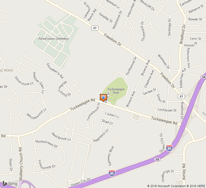
1. Name and location of the property: The property known as the Blythe Homestead is located at 16001 Beatties Ford Road, Huntersville, North Carolina.

2. Name, address and telephone number of the present owners of the property: The owners of the property are:

Mr. John C. Blythe and Mrs. Helen Blythe (wife)
16001 Beatties Ford Road
Huntersville, N. C. 28078

Telephone: (704) 875-6568

Tax Parcel Numbers: 001-022-19 and 001-021-03

Miss Christine Blythe
18110 Hwy. 73 West
Huntersville, N. C. 28078

Telephone: (704) 892-0286

Tax Parcel Number: 001-022-01

3. Representative photographs of the property: This report contains representative photographs of the property.

4. A map depicting the location of the property: This report contains maps which depict the location of the property.


5. Current Deed Book Reference to the property: The most recent deed to this property is listed in Mecklenburg County Deed Book 5042 at page 984.

6. A historical sketch of the property: This report contains a brief historical sketch of the property prepared by John C. Blythe, Jr.

7. A brief architectural description of the property: This report contains a brief architectural description of the property prepared by John C. Blythe, Jr., and Nora M. Black.

8. Documentation of why and in what ways the property meets criteria for designation set forth in N.C.G.S. 160A-400.5:


a. Special significance in terms of its history, architecture, and /or cultural importance: The Commission judges that the property known as the Blythe Homestead does possess special significance in terms of Charlotte-Mecklenburg. The Commission bases its judgment on the following consideration: 1) the Blythe Homestead is an intact homestead dating back to the land acquisition by Samuel Blythe in 1772; 2) the house located on the Blythe Homestead is architecturally significant as an intact and finely preserved example of rural, vernacular architecture constructed in the mid-19th century; 3) the setting of the Blythe Homestead with its pastoral vista is a reminder of Mecklenburg County’s farm past; 4) the outbuildings of the Blythe Homestead represent traditional forms and a variety of construction techniques including a log outbuilding; and 5) the Blythe Homestead, still owned by descendants of Samuel Blythe and including the house, outbuildings, and fields, provides valuable insights into life for early settlers and yeomen farmers of Mecklenburg County.

b. Integrity of design, setting, workmanship, materials, feeling. and/or association: The Commission contends that the architectural description by John C. Blythe, Jr., and Nora M. Black included in this report demonstrates that the Blythe Homestead meets this criterion.

9. Ad Valorem Tax Appraisal: The Commission is aware that designation would allow the owners to apply for an automatic deferral of 50% of the Ad Valorem taxes on all or any portion of the property which becomes a designated “historic landmark.” The current appraised value of the improvements is $48,340. The current appraised value of the 21.69 acres is $619,340. The total appraised value of the property is $667,680. The property is zoned RR and R15.

Date of Preparation of this report: 29 April 1991

Prepared by: Dr. Dan L. Morrill, in conjunction with Ms. Nora M. Black
Charlotte-Mecklenburg Historic Landmarks Commission
1225 South Caldwell Street, Box D
Charlotte, North Carolina 28203

Telephone: 704/376-9115

Note: The following historical report was prepared by Mr. John C. Blythe, Jr., under the auspices of members of the Blythe family. The Charlotte-Mecklenburg Historic Landmarks Commission is not responsible for errors.


Historical Overview
 

Prepared by:
John C. Blythe, Jr.

Samuel Blythe (1727?- 1795?) is reported to have immigrated to America from the northern part of Ireland about 1740.1 In 1772, he acquired from John Wilson four hundred acres of land in Mecklenburg County on the north side of the Catawba River. 2 This is the only listing for Samuel Blythe in the “Grantee Index to Real Estate Conveyances — Mecklenburg County.” Samuel Blythe is believed to have lived in a house that was located on the east side of Beatties Ford Road, less than a mile south of the extant Blythe House. 3

Of his four hundred acres, Samuel Blythe deeded one hundred acres to his son-in-law Thomas Martin in 1789, one hundred and twenty-five acres to his son Richard Blythe in 1790, and two and one-half acres to the Trustees of Gilead Church in 1791.4 His will provides for the “dwelling house and plantation whereon I now live” to go to his grandson William Conner at his wife’s decease. Samuel Blythe died between 1793 and 1796. 5 Of the property he inherited, William Conner deeded nineteen and three-quarter acres to William Henderson in 1798 and one acre to the Trustees of Gilead Church in 1804.6

The one hundred and twenty-five acres deeded to Richard Blythe is believed to be the property on which the Blythe Homestead is located. The 1790 Census shows Richard Blythe as head of a household composed of one male over the age of sixteen and two females. 7 Richard Blythe (1750s?-1800) married Margaret (Peggy) Patton, probably in the 1780s. They had two children, Rebecca (1780s?-1809/18)and Samuel (1790/93?-1866).8 Richard Blythe died on 31 March 1800, 9 and neither he nor his widow is listed as head of a household in the federal census for that year.

One could surmise that Peggy Blythe moved with her two children to the home of her father, Charles Patton, on Gar Creek in the Hopewell community, by the year 1800, and continued to make her home there. When Rebecca Blythe married Anderson Sadler in 1809, Charles Patton was bondsman. 10 Peggy Blythe was still living and had not remarried in 1818, when she was deeded land from her father’s estate. 11

In May of 1818, Anderson Sadler gave his brother-in-law Samuel Blythe a quitclaim deed for property “on the East side of Catabaw [sic] river near to Gillead [sic] Meeting house & East of sd. House being about 162 acres owned & possessed by Richard Blyt12 In August of that same year, Joseph McKnitt Alexander sold Samuel Blythe forty acres “on the Waters of the East side of the Catawba river near “Gillead [sic] Meeting House.” This property was part of a two hundred and fourteen acre tract “subdivided from Samuel Blythe’s tract of 400 acres” Alexander had purchased at a sheriff’s sale in 1813. 13

Samuel Blythe (1790/93?- 1866), son of Richard and Peggy Blythe, married Isabella Nantz (1794/5?- 1876) in 1822.14 The 1830 census lists Samuel Blythe as head of a household; at that time he appears to be living at the Blythe Homestead tract in the Gilead community. 15 It is probable that he either was living in the house occupied by his parents in 1790 or had built a house of his own. 16 Samuel Blythe is reported to have served as postmaster of the Cowan’s Ford post office from 10 June 1847 to 8 December 1866. 17 Samuel and Isabella Blythe had seven children. The eldest, Richard Franklin Blythe (1824-1885), married Violet Jane McCoy (1829-1899) in 1848.18 It is probable that Franklin Blythe built the extant house ca. 1848. 19 Both Samuel and Franklin Blythe were farmers, although the 1850 Census lists Franklin Blythe’s occupation as Constable. 20 During their lifetimes, both men acquired and disposed of tracts of land in the area. Undoubtedly, some of this property included parts of the original four hundred acre tract as well as adjacent parcels. 21

In 1850, Samuel Blythe owned six hundred acres of land, valued at $1800, about a third of which was improved for farming. He had seven horses, six milch cows, eight other cattle, seven sheep, and forty swine. He produced one hundred bushels of wheat, one thousand bushels of Indian corn, two hundred bushels of oats, and smaller quantities of other products. Ten years later, Samuel Blythe had one hundred and seventy acres of improved land and three hundred and thirty acres of unimproved land with a total cash value of $3000. R. F. Blythe had one hundred acres valued at $1200, half of which was improved. Together, they had eleven horses, nine milch cows, three other cattle, fifteen sheep, and thirty swine. The farms produced wheat, corn, oats, cotton, wool, peas and beans, Irish and sweet potatoes, butter, hay, beeswax, and honey. 22

By 1870, Samuel Blythe had died, and his widow and youngest child, Jim (b. 1839), a Confederate War veteran, were the only persons living in their household. 23 Isabella Blythe died in 1876. Jim Blythe never married and lived with different relatives for periods of time throughout his life. The fate of Samuel and Isabella Blythe’s house is not known, although it had disappeared by the early twentieth century. 24

Franklin and Violet Blythe were the parents of eleven children, ten of whom grew up in the ca. 1848 Blythe House and lived to adulthood. The youngest child, John Clifford Blythe (1878-1936), acquired forty-eight acres of the “old homestead of R. F. Blythe” (including the residence) from his siblings and their spouses in 1902. In 1908 he purchased an adjacent twenty-four acres from the W. C. Hastings estate and married Mary Bailes (1883-1976). 25 Cliff and Mary Blythe reared their five children in the Blythe House. Cliff Blythe, like his father and grandfather, made his living as a farmer, and Mary Blythe continued to operate the farm after her husband’s death.

Cliff and Mary Blythe’s youngest son, John Charles Blythe (b. 1921) remained at the homestead and carried on the family tradition of operating a farm, in addition to working full time in Charlotte. He discontinued active farming when much of the property was inundated by Lake Norman in the early 1960s. In 1951, J. C. Blythe married Helen Johnson (b. 1922). They reared their son, John C. Blythe, Jr., (b. 1958) at the homestead and continue to live there. Christine Blythe, daughter of Cliff and Mary Blythe, has maintained a residence at the homestead while living elsewhere.

The construction of Lake Norman in the early 1960’s claimed 27.1 acres of the farmland associated with the Blythe Homestead. The Blythe House was built on high ground and was spared, but many of the pastures and fields were flooded. At the time of the settlement of the Cliff Blythe estate in 1985, an updated survey revealed that 51.75 acres remained. 26 Three contiguous tracts, comprising 21.69 acres, owned and occupied by. J.C., Helen, and Christine Blythe, are proposed for designation as an historic landmark. These three tracts include the house built by R. F. Blythe ca. 1848, the site of the Samuel and Isabella Blythe residence, and associated outbuildings and landscapes. Collectively, this property represents that part of the Blythe property that has neither been developed nor separated from the homesite by the waters of Lake Norman.


Notes

1 John Brevard Alexander, M.D., Biographical Sketches of the Early Settlers of the Hopewell Section… (Charlotte, N.C.; Observer Printing and Publishing House, 1897), p. 62; Annie Blythe Ingram, Notes on the Pedigree of the Family of Blyth or Blythe of Mecklenburg County, North Carolina: Authentic Facts 1752-1959 (Wadesboro, N.C.: unpublished typescript, 1959), p. 2.

2 Mecklenburg County Deed Book 8, p. 88.

3 Family tradition holds that the original Blythe home was located across the road from Gilead Associate Reformed Presbyterian Church, in the same vicinity as the present-day Gilead Church manse.

4 Mecklenburg County Deed Book 13, pp. 618, 758, and 930; Ingram, pp. 3 and 18.

5 Mecklenburg County Will Book A, p. 99, transcribed in Ingram, pp. 5-6.

6 Mecklenburg County Deed Book 16, p. 123; Mecklenburg County Deed Book 18, p. 118; Ingram, pp. 3, 19. No other deeds of William Connor pertaining to this property have been located.

7 Cited in Ingram, p. 4. This suggests that Richard Blythe was living in a home of his own, most probably on the 125-acre tract he acquired that year from his father. Family tradition and physical evidence indicate that there was an earlier residence a few hundred feet south of the extant (ca. 1848) house. This undoubtedly was the house occupied by Samuel and Isabella Blythe in 1850 and may have been the place where the Richard Blythe family was residing in 1790.

8 Ingram, p. 9.

9 Estate Papers of Richard Blythe. The estate inventory lists 125 acres of land, assorted clothing, and one bedstead, suggesting that the household had been broken up prior to his death. These papers reveal that the estate administrator, William Conner (Richard Blythe’s nephew), had also been serving as Richard Blythe’s guardian for several years prior to his death.

10 1800 Census of Mecklenburg County, p. 552; 1810 Census of Mecklenburg County; 1820 Census of Mecklenburg County, p. 166; Ingram, p. 9. Patton’s household in 1800 includes members that could have been Peggy, Rebecca, and Samuel Blythe. Neither Peggy nor Samuel are listed as head of a household in 1810, although they again can be accounted for in the household of Charles Patton. By 1820 Charles Patton had died, and Samuel Blythe was listed as head of a household that appears to be in the same location as the earlier Patton household.

11 Mecklenburg County Deed Book 19, p. 32.

12 Mecklenburg County Deed Book 19, p. 32. The difference in acreage between the 125 acres cited in the inventory of Richard Blythe’s estate and the 162 acres included in the quitclaim deed has not been accounted for.

13 Mecklenburg County Deed Book 19, pp. 345, 800. The 1818 deed further states that “Sd. land does not include any claim of sd. Meeting House land & is to be understood as fairly run within the bounds of the land conveyed by sd. Sheriff….” The 1813 deed describes the property as “Containing 214 acres, exclusive of Gillead [sic] meeting house land.”

14 Ingram, p. 9. A notation in the records of Hopewell Presbyterian Church states that Isabella Blythe died in August 1876.

15 1830 Census of Mecklenburg County, p. 369. Samuel Blythe is listed next to Joseph Walker in the 1830 Census; Joseph was the son of Thomas and Mary Blythe Walker (sister of Richard Blythe), whose property adjoined the original Blythe tract. Other names listed near Samuel Blythe’s in the Census are closely associated with the Gilead community.

16 AIexander states that “Samuel Blythe … occupied the homestead” (p. 62). Ingram writes that the house [referring to the one standing in 1959 and still extant] was built in the early 1830’s by Samuel Blythe.” (p. 10) Alexander’s use of the word “homestead” may not have referred to a house, but it indicates that Samuel lived an the property he inherited from his father. Ingram likely was mistaken regarding the construction of the extant house by Samuel Blythe in the early 1830s (see footnote 19), but may have been correct in the fact that Samuel Blythe built a house — the one that stood to the south of the extant house and in which he was living in 1850 and 1860.

17 Ingram, p. 9.

18 Ingram, pp. 9-10.

19 Alexander, p. 62; 1850 Census of Mecklenburg County, pp. 32-33. Alexander writes, “Franklin married Violet McCoy, and built a house in the northern part of the homestead.” Because Alexander was a neighbor and about 14 years of age in 1848, he likely had firsthand knowledge of the house’s construction. The 1850 census shows R. F. and Violet Blythe living adjacent to (and apparently north of) Samuel and Isabella Blythe. This census information also lends credibility to the supposition that the earlier house on the property was the homestead of Samuel (and possibly Richard) Blythe. Moreover, the form and profile of the R. F. Blythe House bear a striking similarity to the Rozzelle House (about seven miles away), reported to have been built in 1849 (burned and demolished in 1990).

20 1850 Census of Mecklenburg County, pp. 32-33; 1860 Census of Mecklenburg County, p. 159.

21 Grantee and Grantor Indexes to Real Estate Conveyances -Mecklenburg County. Among the parcels sold were two (237.5 ac. & 54.5 ac.) to James and William C. Hastings.

22 1850 Agricultural Census of Mecklenburg County, p. 889; 1860 Agricultural Census of Mecklenburg County, p. 9.

23 1870 Census of Mecklenburg County, p. 166; Ingram, pp. 9, 15.

24 Records of Hopewell Presbyterian Church; Personal communication of various members of the Blythe family. Mary Bailes Blythe (1883-1976) moved to the Blythe homes as a bride in 1908; the earlier house was gone by that time. Jim Blythe lived with Cliff and Mary Blythe for a period early in their married life; he died and was buried in Raleigh, N.C.

25 Ingram, pp. 10, 23-31; Mecklenburg County Deed Book 241, p. 573; Mecklenburg County Deed Book 232, p. 570.

26 Mecklenburg County Deed Book 2267, p. 251; Spratt & Brooks Land Surveying, “Boundary Survey of John C. Blythe Est. Divided” (12 September 1984).


Architectural Description
 

Prepared by:
Mr. John C. Blythe, Jr. and Ms. Nora M. Black

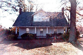
The Blythe Homestead is located at the termination of Beatties Ford Road and the south shore of Lake Norman in northern Mecklenburg County. The property is approximately one-tenth of a mile northwest of the intersection of Beatties Ford Road with N.C. Highway 73. The house is situated on the tax parcel on the southwest side of Beatties Ford Road. The two additional tax parcels that comprise the homestead are located on the northeast side of Beatties Ford Road.

The Blythe House is believed to have been constructed ca. 1848; a large addition was constructed in 1928. Other modifications were made as early as the late 1800s and as recently as 1989. These alterations reflect the size, needs, and financial condition of the family at various times.

As originally built, the facade of the house was oriented to the South, rather than to the East and Beatties Ford Road. This peculiar orientation may be explained by taking into account the earlier Blythe house, located several hundred feet to the South. Family members recall “the old road” which ran from the general vicinity of the earlier house toward the south facade of the ca. 1848 house before curving back toward Beatties Ford Road.

In 1928, Cliff Blythe reoriented the facade to the East. The rear wing of the house was removed, and a new, larger wing was built. A driveway was constructed, leading straight from Beatties Ford Road to the new front entrance. The original facade remains, but is not readily noticeable from Beatties Ford Road. Family members still refer to the south elevation as the “old front” and the east elevation as the “new front.”


EXTERIOR

The entire house has siding of lapped horizontal boards painted gray. Window and door surrounds, porch supports, roofline trim, and cornerboards are painted white. The window surrounds are very simple and undecorated; they consist of wide boards with no moldings. Windows vary in each wing, but they are generally composed of 4/4, 6/9, and 6/6 double hung sash.

Neither the roof nor the wall surface is the dominant feature of the house; the view upon approach is dominated by the one-story porch that wraps the house. The gray fiberglass shingle roof has a low pitch over the ca. 1848 wing; the roof pitch is steeper over the ca. 1928 wing. The gable ends have a moderate overhang; the cave overhangs are boxed and have shingle moldings.

The ca. 1848 wing of the Blythe House is a two-story, rectangular, gable-roof building of mortise-and-tenon construction, sheathed in painted weatherboarding. The three-bay facade has a central, single-door entrance on the first story. All windows in this wing are single. Each gable end features a centrally-placed, exterior, brick chimney on a fieldstone foundation. Two windows were located on each story, and the lower end of each bargeboard has sawn ornamentation. The house rested an piers of fieldstone. A dug cellar is located beneath the southwest room. The house as originally constructed was a typical ‘I-House.’

The earliest change to this section of the house apparently was the reconstruction of the roof structure. Family members do not recall having heard anything about this alteration, and physical evidence suggests that it occurred quite early. Tell-tale signs of the change are the pole rafters (rather mortise-and-tenon framing) and the extension of the roof to intersect with the chimneys.

It is presumed that the first-story windows originally held nine-over-nine sash and the upper-story windows held nine-over-six sash. By 1923, the lower sash had been replaced by four-over-four sash. The upper-story sashes had deteriorated by 1966 and were replaced. As many of the original panes as could be salvaged were reused in an attempt to replicate the original windows; however, the contractor installed the sash incorrectly resulting in the present six-over-nine configuration.

The east chimney was coated in plaster about 1928, and the west chimney was painted in an attempt to arrest deterioration of the soft brick. In 1965 the fieldstone piers were replaced with a solid brick foundation. Two of the windows in the west elevation have been removed in order to add a bathroom on each story.

The earliest documented porch, as shown in ca. 1923 photographs, had a hip roof supported by four chamfered posts. Sometime during the 1920s, these posts were replaced by boxed pillars. In 1989, the chamfered posts were replicated and installed at the original locations.

The ca. 1928 wing is probably at least the third structure in this location. It replaced a much smaller wing built by Cliff Blythe about the turn of the century. What preceded that wing is not known, but it is likely that there was a shed wing, gabled ell, or breezeway/kitchen. Older family members recall vague references to a rear porch on the east side of the rear wing, but no one now living remembers such a configuration.

The wing built by Cliff Blythe about the turn of the century was a gable-roof ell containing a dining room and kitchen. It was attached to the east side of the rear, and a porch was located along its west elevation. In 1928, the wing was detached from the house and moved to a site adjacent to the old garage, where it served an outbuilding until it collapsed and was torn down in 1986.

The 1928 addition not only provided much more room for the family, but also acknowledged the owner’s desire to have his home face the main road. By this time the old house had been long gone, and there was no need for the long driveway that led to the old (ca. 1848) front of the Blythe House. Cliff and Mary Blythe determined to create a “new” house, facing Beatties Ford Road for the first time. The new wing contained a living room, dining room, kitchen, and back porch on the first story, and a large bedroom upstairs. An interior brick chimney served fireplaces in the living and dining rooms.

To reinforce the creation of the new facade, the old front porch was extended along the entire east elevation, and a driveway, leading in a straight line toward the new front door, was built. The horizontal lines of the new porch served to tie the old and new wings together visually and softened the verticality of the original gable end and chimney that otherwise would have been much more prominent. The strategic placement of trees and other plantings further helped to define this new orientation.

The 1928 wing is of frame construction, sheathed in painted weatherboarding. The gable roofs have boxed cornices, as does the original wing. The windows have four-over-four sash to match that installed earlier in the ca. 1848 wing. All windows are single, with the exception of those in the living and dining room, which are paired. The porch roof is supported by half-pillars on brick piers. In 1989, the porch was extended to wrap around the northeast comer of the house, connecting the roofs of the front and back porches.


INTERIOR

The interior of the house has been modified numerous times and retains little of its original fabric. The placement of the stair along the rear wall of the ca. 1848 wing suggests that the house originally had a hall-and-parlor plan, rather than a central hall with flanking rooms. Physical evidence reveals that the bottom four steps originally opened into the downstairs room; planed board paneling in the stairwell above this level appears to be original. The stair has been enclosed throughout the twentieth century. By 1908, when Mary B. Blythe moved to the house, there was a central hall. This was removed ca. 1950. The original first story floor has been replaced or covered with hardwood. The upper floor of the ca. 1848 wing has original, pine floors. In 1908, the upper story was a single room. Partitions were added soon thereafter. These were removed and new partitions installed in 1966.

The interior of the 1928 wing retains the original brick mantel in the living room. The hardwood floors and beaded ceilings on the first story are intact but obscured. Plaster walls in the living and dining rooms were replaced with sheetrock in 1965, but the picture and crown moldings were replicated. French doors connect these two rooms.


SETTING AND OUTBUILDINGS

Although the Blythe House is the central focus of the Blythe Homestead, it is only one component of the property’s significance. Other components include a smokehouse, well house, garage, terraced field, orchard site, fence rows, and sites of several farm buildings.

The smokehouse is a two-story, square-cut log structure located to the West of the house. The logs are joined with half-dovetail notching. The end gables are covered with planks since the logs extend only as high as the ceiling joists. The roof is covered with metal sheets; the open eaves have exposed rafters. Some chinking is still evident between the logs. The first story is probably contemporary with the earliest part of the residence; the second story was added by Cliff Blythe, probably ca. 1900. A frame garage was attached to the north side of the smokehouse in the early twentieth century.

The structure closest to the Blythe House is the well house, a frame building located to the North of the residence. The metal-roofed structure has board siding. Approximately one-half of the structure is enclosed; the other half is open although roofed. It was probably built by Cliff Blythe in the early twentieth century.

The chicken house was converted into a garage in the early 1960s. This building is located northwest of the well house. It is a frame building with horizontal weatherboarding. Metal roofing covers the gable roof.

Other buildings that once stood on the nominated property include the earlier Blythe House, the ca. 1900 kitchen/dining room wing, baths (at least three), gear room, crib, privy, woodshed, blacksmith shop, and another kitchen. The approximate sites of these are known, but no excavations have been undertaken to evaluate their archaeological potential.

A prominent landscape feature directly across Beatties Ford Road from the Blythe House is a terraced field. The original terracing was accomplished in the early 1930s with assistance from the Civilian Conservation Corps; it was redesigned in the 1950s. This is the last remaining field contiguous to the homesite.

The old orchard was planted to the South of the Blythe House by Cliff Blythe in the early twentieth century. This area includes the site of the earlier Blythe House. Many of the fruit trees were diseased and dying by the 1960s, and J. C. Blythe planted a new orchard of dwarf fruit trees in the corner of the old orchard nearest the Blythe House. The far end of the orchard has been allowed to grow up in pine, dogwood, and cherry laurel trees to screen noise generated by traffic on NC Highway 73.

When Lake Norman flooded the original pastures and fields, the farm buildings became obsolete, as did the fences that separated different areas of the farm. Gradually many of the fences were removed, but their locations are marked in some areas by shrubbery and trees that grew up along them.

Lake Norman forever altered the landscape of the Blythe homestead, but just as the lake has become a part of Mecklenburg County’s history, it has become a part of the Blythe Homestead’s history. Unlike their nearest neighbors, the Blythes were fortunate that their home was spared from the lake’s floodwaters. The family is challenged now with determining the role of the homestead in its changing environment, particularly in the face of mounting development pressures. Just as Cliff and Mary Blythe sought to reorient their home to the Beatties Ford Road in 1928, the present and future generations will seek to adapt the homestead for its new situation, taking care to preserve that which has been left by previous owners.


James A. Blakeney


This report was written on February 5, 1986

1. Name and location of the property: The property known as the James A. Blakeney House is located on the Blakeney Heath Road in the Providence Community of Mecklenburg County, North Carolina.

2. Name, address, and telephone number of the present owner of the property: The owner of the property is:

Willie Blakeney Life Estate et al.
2025 East Eight St.
Charlotte, NC 28204

The present occupant of the property is:

Margaret Blakeney Bullock
Telephone: 704/542-3705

3. Representative photographs of the property: This property contains representative photographs of the property.

4. A map depicting the location of the property: This report contains a map which depicts the location of the property.


5. Current Deed Book Reference to the property: The most recent deed to this property is recorded in Mecklenburg County Deed Book 4641, Page 948, The Tax Parcel Number of the property is 229-051-06.

6. A brief historical sketch of the property: This report contains a brief historical sketch of the property prepared by Dr. William H. Huffman.

7. A brief architectural description of the property: This report contains a brief architectural description of the Property prepared by Dr. Dan L. Morrill.

8. Documentation of why and in what ways the property meets the criteria for designation set forth in NCGS 160A-399.4:


a. Special significance in terms of its history , architecture, and/or cultural importance: The Commission judges that the property known as the James A. Blakeney House does possess special significance in terms of Charlotte-Mecklenburg. the Commission bases its judgment on the following considerations: 1) the James A. Blakeney House it a well-preserved example of a type of farmhouse erected by prosperous farmers in Mecklenburg County in the late nineteenth and early twentieth centuries; 2) the James A. Blakeney House and outbuildings constitute a rare combination of agriculturally-related edifices in a section of Mecklenburg County which is experiencing rapid suburbanization and 3) the James A. Blakeney farm might contain important historic and pre-historic archaeological artifacts.

b. Integrity of design, setting, workmanship, materials, feeling, and/or association: The Commission contends that the architectural description included in this report demonstrates that the property known as the James A. Blakeney House meets this criterion.

9. Ad Valorem Tax Appraisal: The Commission is aware that designation would allow the owner to apply for an automatic deferral of 50% of the Ad Valorem taxes on all or any portion of the property which becomes “historic property.” The current appraised value of the house is $11,740. The current appraised value of the 109.75 acres of land is $26,610. The total appraised value of the property is $38,350.

Date of Preparation of this Report: February 5, 1986

Prepared by: Dr. Dan L. Morrill
Charlotte-Mecklenburg Historic Properties Commission
1225 S. Caldwell St. Box D
Charlotte , NC 28203

Telephone: 704/376-9115


Historical Overview
 

by Dr. William H. Huffman
January, 1986

The James A. Blakeney House in southern Mecklenburg County is an endangered species. This once model farm that was toured by schoolchildren is now in danger of disappearing along with many others in rural Mecklenburg County, victims of ever-spreading suburban development. Built about 1905-06, the house still retains a fundamental soundness in addition to its rural charm that evokes the sense of the pace of turn-of-the century farm life.

About 1890, a precedent-setting occasion took place at Providence Presbyterian Church: the minister, Roger Martin, officiated at the wedding of his daughter, Margaret Tomlin Martin (1864-1917) and James Albert Blakeney (1856-1928). It was the first wedding ceremony performed in the church; previously, couples were married at home. The preacher, a Richmond, Va. native, served Providence from 1888 to 1892, when he took the pastorate at Mallard Creek, a post he held until his death in 1900.1

James A. Blakeney’s father, Reese Blakeney, a South Carolina native, had gone into the Confederate service during the Civil War, and had not returned at war’s end, his fate unknown. His mother, born Caroline Kirkley, subsequently married J. P. Doster, and about 1883 they settled near the present Blakeney House to farm in southern Mecklenburg County. 2 James Blakeney and his stepfather farmed together on the latter’s land for several years, and in 1887 Blakeney bought just over 39 acres of his own, and built a log cabin to live in. 3 It was here that the newlyweds set up housekeeping about 1890.

About 1897, the Dosters moved to Hickory N.C., and James bought about half of their holdings, a 60-acre tract (he bought their remaining 76 acres in 1911) near his own. 4 On this larger property, he built a one-story residence for his growing family on the site of the present house which sat next to the road that bisected his farm. The farm prospered and the family continued to grow. but it was a fire a few years after the turn or the century that made a new house necessary, and so the one we see today was put up about 1905 or 1906. 5

By 1910, the Blakeneys were farming about 232 acres and had brought eight children into the world (seven daughters and one son), six of whom survived to adulthood. 6 Unfortunately, about 1913 James Blakeney suffered a stroke, and management of the farm was undertaken by Dr. Alexander Martin, Margaret’s brother, who came up once a week from Rock Hill, S. C., where he was pastor of the Oakland Avenue Presbyterian Church for many years. 7

When he came of age, James A. Blakeney, Jr. (1901-1973) took over management of the farm, and about 1930 married Wilma Alma Blount (1906-) of Roper, N.C., a descendant of Capt. James Blount, who died in North Carolina in 1686. 8 During their long tenure on the farm, James A. Jr. and Willie Blakeney raised three children, Margaret, Frances and James III. And it was also during this time that schoolchildren used to tour the farm to see, among many other wonders, old wagons and farm implements now found only in museums. 9

Following the death of James A. Jr. and Willie Blakeney’s move to a nursing home, the house suffered some neglect, but since 1983 it has been reoccupied by Margaret Blakeney Bullock, who has undertaken careful interior restoration of the fine farmhouse, and intends to continue the efforts to completion.

The James A. Blakeney House is a splendid representative of a vitally important part of our cultural heritage, and these days, an ever rarer one. Its preservation would insure that we would always retain a strong sense of our own development; what we are, and who we are.


Notes

1 Louise Barber Matthews, A History of Providence Presbyterian Church (Matthews, NC: Providence Presbyterian Church, 1967), pp. 176 -181; interview with Eudora Blakeney Garrison, Charlotte, N.C., 30 January, 1986.

2 Interview with Eudora Garrison: interview with Margaret Blakeney Bullock. 16 January, 1986. Mecklenburg County Deed Book 33, p. 137, 16 Feb. 1883.

3 Deed Book 224, p. 662, 1 Feb. 1887; interviews with Eudora Garrison and Margaret Bullock.

4 Deed Book 117, p. 116, 27 Jan. 1897; Deed Book 269, p. 708, 8 March 1911.

5 Interviews with Eudora Garrison and Margaret Bullock.

6 Bessie Blakeney McAlwaine (1891-1935), a longtime missionary to Japan; Lina B. Ardry (1893-); Harriet Caldwell Blakeney (c.1894-1900); Edmonia Martin Blakeney (1896-1950); Margaret Blakeney Richardson (1900-c.1980); J. A. Blakeney, Jr. (1901-1973); Grace Hoge Blakeney (1904-1906); Eudora Blakeney Garrison (1906-).

7 Matthews, History, cited above; interview with Eudora Garrison.

8 Family Bible of Wilma Alma Blount Blakeney; interviews with Eudora Garrison and Margaret Bullock.

9 Interviews with Eudora Garrison and Margaret Bullock.


Architectural Description
 

The James A. Blakeney House (ca. 1905-06) is a three-bay wide by four-bay deep, two story, frame farmhouse, with a tin-roofed, one-story projection on the rear that contains a kitchen, porch, larder room, and bathroom, the last having been added in recent years. It is located on Blakeney Heath Road in the Providence community of Mecklenburg County, NC and faces north. In addition to the main house, the property contains several outbuildings, including a barn, two tenant houses, a chicken house, cotton house, corn crib, shop building, pig pen, and a garage. Moreover, a substantial number of pre-historic archeological artifacts, principally arrowheads, have been found on the property, suggesting that it might possess archeological significance.

The James A. Blakeney House is a rather typical example of a type of dwelling which prosperous farmers erected in Mecklenburg County in the late nineteenth and early twentieth centuries, The Charlotte-Mecklenburg Historic Property which most resembles it is the N. S. Alexander House, erected in 1903, Although the James A. Blakeney House is not unique, it is one of the few surviving remnants of the built environment which was associated with the cotton economy of southern Mecklenburg County at the turn of the century. Indeed, this writer is aware of only four other farmhouses of similar or earlier vintage which survive in the general vicinity of the James A. Blakeney House, Also noteworthy is the fact that this section of Mecklenburg County is undergoing rapid suburbanization. Consequently, the house and land are clearly endangered.

Victorian motifs are evident on the exterior of the James A. Blakeney House — the large bay on the left front, the decorative detail on the second floor windows of the bay, the slate-covered gable roof and two cross gables, the wood shingles in the gable ends, the large, tin-roofed wraparound porch, and the Wooden lattice at the right rear of the wraparound porch. The overall massing of the house, however, as well as its architectural appointments, are quite simple, even rustic. The house, for example, rests on brick piers with subsequent brick in-fill, and the dominant exterior wall covering is clapboard. The fascia of the cornice of the wraparound porch is composed of small vertical boards of unrefined design. The house contains an offset right chimney and an offset left chimney, plus a chimney at the rear of the kitchen, Seven lightning rods are atop the house. The fenestration is irregularly punctuated, and dominant window type is 2/2 double sash, with the windows on the right front of the first floor extending to the floor of the wraparound porch.

The house also contains suggestions of classical revivalism. Arched windows with keystones punctuate the front gable ends of the cross gables, and sixteen Doric columns support the roof of the wraparound porch. But the overall treatment of the house suggests to this writer that the edifice was the work of a local builder and should be labeled ‘vernacular’.

The front door is pine with a single, large glass, no sidelights but a transom, and broadly-fluted pilasters with a bull’s eye-decorative element in each base. The interior of the James A. Blakeney House is largely unchanged from the original. The hardware, the doors, the mantels in the eight fireplaces, the plaster walls, the magnificent pine wainscoting, and the newel posts, pickets, and handrail of the straight staircase which rises forward from the rear of the central hallway, are all original.


Survey and Research Report

 on the

 Jesse and Mary K. Washam Farm

washamhsefront

1.  Name and location of the property:  The property known as the Jesse and Mary K. Washam  Farm is located at 15715 Davidson-Concord Road in Davidson, North Carolina.

2.    Name, address, and telephone number of the current owner of the property:

Joe K. Washam
15715 Davidson-Concord Road
Davidson, NC 28036

JAGCO Associates
19449 Peninsula Shores Dr.
Cornelius, NC 28031

3.Representative photographs of the property: This report contains representative photographs of the property.
4.A map depicting the location of the property: This report contains a map depicting the location of the property. UTM Coordinates:  17 520852E 3921709N
5.Current deed book reference to the property: The most recent deeds to the property are found in Mecklenburg County Deed Book 6254, page 201 and 7090, page 413.  The tax parcel numbers for the property are 011-092-14 011-092-05.
6.A brief historical sketch of the property: This report contains a brief historical sketch of the property prepared by Emily and Lara Ramsey.
7.A brief architectural description of the property: This report contains a brief architectural description of the property prepared by Emily and Lara Ramsey.
8.Documentation of why and in what ways the property meets the criteria for designation set forth in N.C.G.S. 160A-400.5.
a.Special significance in terms of its history, architecture, and/or cultural importance.  The Charlotte-Mecklenburg Historic Landmarks Commission judges that the Washam Farm possesses special significance in terms of Charlotte-Mecklenburg.  The Commission bases its judgment on the following considerations:

1)       The Washam Farm is a tangible reminder of the last prosperous decades of Mecklenburg County’s agrarian economy, before regional and nation-wide depressions effectively ended the reign of King Cotton and the small farmer in the South.

2)      The Washam Farm is an integral part of the Ramah Community in northeast Mecklenburg County and an important part of the rural corridor that runs along Davidson-Concord Road.

3)      The Washam Farm is an excellently preserved example of a twentieth-century farmstead – the house and eclectic collection of early-twentieth century outbuildings form a comprehensive complex that retains its original pastoral setting despite nearby residential and commercial development.

4)      The Washam Farmhouse, originally a three-room tenant house, is indicative of Mecklenburg County’s small farmsteads, which expanded and evolved to fit the needs of growing families and changing farming operations.

5)       The Washam farmhouse is a rare surviving example of a bungalow farmhouse in Mecklenburg County, reflecting the influence of current architectural trends and the intimate connection between the area’s small towns and the surrounding countryside.
b.Integrity of design, setting, workmanship, materials, feeling and/or association: The Commission contends that the architectural description prepared by Emily Ramsey and Lara Ramsey demonstrates that the Washam Farm meets this criterion.
9.Ad Valorem Tax Appraisal: The Commission is aware that designation would allow the owner to apply for automatic deferral of 50% of the Ad Valorem taxes on all or any portion of the property which becomes a designated “historic landmark”.  The current appraised value on the farmhouse is $44,650.00.  The current appraised value of the 1.47-acre parcel of land on which the house and majority of the outbuildings stand (owned by Joe Washam) is $34,570.  The current appraised value of the 84.79-acre tract owned by JAGCO Associates is $680,190.00

Date of preparation of this report:  January 30, 2002

Prepared by:

Emily Ramsey and Lara Ramsey
2436 N. Albany Ave., Apt.  1
Chicago, IL 60647
Statement of Significance

Jesse and Mary K. Washam Farm
15715 Davidson-Concord Road
Davidson, NC

Summary

The Jesse and Mary K. Washam Farm is a property that possesses local historic significance as a tangible reminder of the last prosperous years of Mecklenburg County’s once thriving agrarian economy, before regional and nation-wide economic depressions ended the era of southern dominance over cotton production and the autonomy of small, independent cotton farmers, and as an integral part of the closely-knit farming community centered around Ramah Presbyterian Church.  When Jesse Washam began farming operations in the early 1900s on the modest parcel of land left to him after his father death, Mecklenburg County farmers were in the last years of a prolonged economic boom that had begun in the last quarter of the nineteenth century.  Charlotte, with its four converging rail lines, had become a thriving cotton trading center in the postbellum period and served as the heart of a profitable cotton textile region that covered North and South Carolina, Tennessee, and Georgia.

Small farmers across the county took advantage of high cotton prices and close proximity to Charlotte by planting cotton as their major cash crop, and many prospered during the late nineteenth and early twentieth centuries.  Although Mecklenburg County would remain largely agrarian until after World War II, the good times for small farmers came to an abrupt halt by the late 1920s and early 1930s.  Henry Washam, Jesse’s father, had taken advantage of this earlier prosperity by buying a large parcel of land in the Ramah Community between Davidson and Huntersville, where he planted and raised cotton with the help of several tenant farmers.  The Washams took their place as part of the Ramah community, a small and closely-knit group of Scots-Irish farming families.  Henry made a good living from his sizeable farming operation; by the early 1910s, when Jesse moved into one of his father’s former tenant houses and began growing cotton, the cotton boom in Mecklenburg County was beginning to fade.  Jesse Washam’s renovation and major expansion of the three-room house in the early 1920s was a product of the last prosperous years for the area’s small-scale cotton farmers.

The Washam Farm is also significant as an excellently preserved example of a twentieth-century farmstead.  The house and collection of early-twentieth century outbuildings, which includes a large barn, tool shed, corn crib, chicken and brooders houses, a cotton shed, a tenant house, and a concrete-block  well house (an early and unusual example of hand-formed concrete block construction echoed in the nearby Bradford store), form a comprehensive complex that retains its original pastoral setting despite nearby residential and commercial development.  Originally a three-room tenant house, the Washam Farm is also significant as a representative example of the evolution of farm complexes.  The numerous changes and additions to the house and the outbuildings, most completed in the early twentieth century, are indicative of Mecklenburg County’s small farmsteads, which expanded and evolved to fit the needs of growing families and changing farming operations.  In addition, the house itself is a rare surviving example of a bungalow farmhouse in Mecklenburg County; although bungalows were popular throughout the county’s numerous small towns and in Charlotte, the Washam House represents a break from the area’s typical farmhouse, most of which were simple frame I-houses.

Agricultural Context and Historical Background Statement

Between 1860 and 1910, Mecklenburg County’s agricultural economy experienced a prolonged period of prosperity that would ultimately be its last.  The North Carolina piedmont, never a major player in the plantation economy that characterized the antebellum South, had ultimately profited from its status as a land of small-scale farms – after the Civil War, the majority of Mecklenburg County farmers, having never been dependent on slave labor, were able to replant and recover quickly after the war.1  In addition, the post-war period brought new opportunities to the small farmer – new opportunities in cotton.  The introduction of the fertilizer Peruvian Guano, which made cotton (a notoriously difficult and labor-intensive crop) easier to grow, meant that cotton was, for the first time, a profitable cash crop for even the most modest farmer.  Close proximity to Charlotte, which had emerged by the turn of the century as a regional cotton trading center and burgeoning cotton textile hub, gave farmers easy access to a far-reaching market for their cotton crops.  The impact of these developments was reflected in the rapid increase in the production of cotton in Mecklenburg County – between 1860 and 1880, the number of cotton bales produced in the county tripled, from 6,112 bales to 19,129 bales.2

The cotton boom would continue well into the twentieth century – cotton production peaked in the county in 1910 at 27,466 bales – but by the mid-to-late-1920s, the cotton market in Mecklenburg County and across the South was faltering.  What had been a magic crop at the turn of the century became a liability by the beginning of the Great Depression, when cotton prices dropped to an all-time low of around five cents per pound.  The arrival of the boll weevil in the early 1920s, capable of devouring entire fields of plants in a matter of days, compounded the problems of small-scale cotton farmers, many of whom could not afford the expensive pesticides and equipment that were needed to make cotton profitable in the twentieth century.3  In 1910, Mecklenburg County’s urban population surpassed its rural population for the first time in the county’s history.  Ten years later, the census reported the county’s first recorded decrease in farm production.  The Great Depression accelerated the migration from farm to city; between 1930 and 1940, the number of farms in Mecklenburg County dropped from 3,773 to 3,223.4

When the Washam family first settled in the Ramah community in northern Mecklenburg County, between Davidson and Huntersville, King Cotton was far from its eventual demise –farmers were planting and harvesting cotton at an unprecedented rate with the help of tenant farmers, and Henry Jackson Washam was eager to profit from the economic boom.  Henry Washam began farming a thirty-acre plot of land along the Davidson-Concord Road, which he most likely acquired through his marriage to his first wife, a Shields, in the mid-nineteenth century.  He and his family lived in a simple, frame I-house (no longer extant), raising cotton and corn as primary cash crops.  As Henry’s farming operations proved successful in the midst of the post-Reconstruction cotton boom, he began acquiring additional plots of land; by the time of his death around 1901, his farm totaled almost 200 acres on the north and south sides of Davidson-Concord Road and included the main house along with numerous scattered outbuildings.  Henry Washam’s third wife, Julia Washam, procured, after filing suit against her stepchildren, one-third of her husband’s farmland, in addition to the farmhouse that had served as the seat of the Washam’s farming operations.5 Jesse Washam, who had left the family home in Ramah and moved to Cornelius to live with his uncle, Mack Washam, around the time of his father’s death, inherited just under 32 acres and one of the farm’s three tenant houses.  Jesse did little with the inheritance initially; however, after his marriage to Mary K. Knox (a native of nearby Caldwell Station and member of Bethel Presbyterian Church) in 1909, Jesse Washam returned to the Ramah Community, moved into the modest three-room house on his property, and began farming.  Within a few years,  he had earned enough through cotton to buy three adjoining plots of land; by 1913, Washam had acquired approximately 110 acres of his father’s original farmstead.6  The family grew corn and grain in addition to cotton as major cash crops; Jesse took his cotton to be ginned just down the road, at Hurd Bradford’s store, and sold the ginned cotton to local mills in nearby Huntersville and Davidson.7

Throughout the 1910s and 1920s, Jesse Washam made several changes and additions to his farmstead, including a side addition to the already existing barn, a new chicken coop, tool shed and a cotton shed.  With the help of his teenage sons, Washam dug a basement and constructed a solid brick foundation beneath the house; the family used the cool space to store canned fruits and vegetables.8  By 1922, Washam was successful enough to undertake a major renovation on the house itself, one which he doubtless hoped would transform the former tenant house into a more fitting centerpiece for his prosperous farmstead, in addition to providing much needed room for his growing family.9  The addition roughly tripled the size of the house and completely changed its appearance.  By the mid-1920s, the original three-room house was completely obscured behind a new, stylish front – passerby on the Davidson-Concord Road saw not a modest hall-and-parlor farmhouse, but a spacious, one-and-a-half story bungalow cottage.

This expansion was the product of  Jesse Washam’s last prosperous years as a cotton farmer.  By the beginning of the Great Depression in 1929, cotton prices had already slipped considerably, and farmers throughout Mecklenburg County were forced to reduce their crop and livestock production or sell their farms.  Although Jesse Washam managed to weather the hard times and keep his farmstead, his farming operations were never as profitable as they had been in the first decades of the twentieth century.  In 1939, Jesse Washam died at the age of 59.  Fred Washam took over farming operations, and Mary K. and several of the children stayed in the house until the 1960s.  Mary K. Washam died in 1963, and the Washams planted their last cotton crop in 1965; as Joe Washam recalled, “There was the boll weevil, and that made everything hard, and that year there was a killing frost, and most people around here just didn’t plant cotton the next year.  You couldn’t make money off it unless you had a cotton picker and at least couple of hundred acres.”10  Eventually, only Joe Washam remained in the house, and in the 1990s, the family sold all but 1.47 acres (on which the house and most of the outbuildings stand) of the remaining land.  Joe Washam owns the family home and 1.47 acres, and currently lives in the house.  Jagco Associates currently owns the 84-acre parcel behind the house, including the farm’s barn, chicken house and cotton shed – a portion of this parcel should be included as part of the local landmark designation, as it contains not only several significant outbuildings, but also the open fields and pastoral vistas that anchor and provide a visual context for the buildings.

Architectural Significance and Context Statement

Architecturally, the Washam House is significant as a rare surviving example of a bungalow farmhouse in Mecklenburg County.  The vast majority of farmhouses within the county were constructed during the earlier years of the post-war cotton boom, roughly between 1860 and 1900, and the continued popularity of the traditional I-house form (a one-or-two-pile, two-story, side-gable structure) reflected the conservative nature of the county’s typical rural homebuilder.  By the 1910s and 1920s, when the Craftsman bungalow reached its peak as “the most popular and fashionable smaller house in the country,” this rural building boom had ended, and most of the modest and affordable bungalows built in Mecklenburg County were constructed within Charlotte and in the area’s surrounding small towns.11  Those farmhouses that were built in the early twentieth century reflected a continued “kinship” between Mecklenburg’s small towns and the surrounding countryside.  Traditional rural designs had characterized the early buildings of such small towns as Huntersville and Davidson; by the 1920s, popular urban styles – primarily Craftsman bungalows and Colonial Revival forms – were finding their way onto the farm.12  The Washam farmhouse, after its renovation and expansion in 1922, exhibited all of the traits of a typical Craftsman bungalow, including low, overhanging eaves with exposed rafter tails, large gabled dormer, and a porch with tapered columns set on low brick piers.  This house, transformed from a plain, utilitarian tenant house into a stylish and spacious bungalow, was a fitting reflection of modest but prosperous farming operation that Jesse Washam had made during the first decades of the twentieth century.

The Washam Farm is also significant as an excellently preserved example of a twentieth-century farmstead in Mecklenburg County and as a representative example of the area’s constantly evolving farm complexes.  The typical farm in late nineteenth and early twentieth century Mecklenburg County was a self-sufficient complex, supporting not only cash crops like corn, cotton and grain, but also a variety of livestock (mainly hogs, cows and chickens) and kitchen gardens for family consumption.  The daily operation of an early twentieth century farm required an array of barns, storage sheds, and other outbuildings in addition to the farmhouse itself.  At a time when many of Mecklenburg County farmers were paring down their operations or taking jobs in nearby towns, Jesse Washam remained largely self-sufficient – as late as 1935, he was adding to his farmstead.  The large number of remaining outbuildings at the Washam farmstead are as significant a part of the farm as the house itself, because, as historians Richard Mattson and William Huffman explain, “the more historically complete and intact the farmyard, the more it reveals about the operations of the farm” and the diverse activities that made up daily life on that farm.13

Physical Description

The Washam Farm is situated on the south side of Davidson Concord Road, on a 1.47-acre lot surrounded by open fields.  The house, a one-and-a-half story side-gable bungalow with white-painted weatherboard siding, is fronted by a large front lawn shaded by mature oak trees, and surrounded by the farm’s outbuildings.  The house itself is a rambling one-and-one-half-story side-gable structure covered in white-painted wooden clapboards, with an integrated porch running the entire length of the façade.  The original portion of the house now forms a large rear wing, with a covered side porch running along its eastern side up to the 1922 portion of the house.  The  1922 front addition, three-bays-wide by two-bays-deep, features two-over-two windows, two side chimneys with decoratively corbelled tops, low overhanging eaves with exposed rafter tails, and a centrally located front-gabled dormer with paired windows.  The interior of the house has remained virtually unaltered since the 1922 addition, with original fireplace mantels, hardwood floors, decorative wainscoting, a simple central staircase with original newel posts and railing, and original interior doors with hardware.  The eastern chimney was largely replaced after Hurricane Hugo damaged it in 1989; the kitchen in the original portion of the house has been significantly altered, and a new passageway was recently opened up between the other two rooms in the original wing.

The Washam farm complex contains seven outbuildings, most of which date from the 1920s and early 1930s.  The oldest and largest of these outbuildings is the white-painted frame barn with stepped tin roof, portions of which may date from the late 1800s, which sits to the rear of the house, just south of Joe Washam’s property line.  The barn contains six stalls on the ground level and a large open hayloft above.  A large frame tool and equipment shed, with a lean-to side addition used for the Washam’s tractor, and a combination corncrib and tool shed  (also a white frame structure) stand between the main house and the barn.  Two small, unpainted frame structures on the east side of the complex, also across the Washam boundary line, were originally used as a cotton shed (where farmers stored cotton while waiting for prices to rise) and a brooder house – a chicken house used for small chicks, complete with a small furnace to keep the chicks warm.

By far the most interesting outbuilding on the property is the 1935 well house.  While most farm outbuildings in the county were simple frame structures, farmers occasionally branched out into newer building technologies.  Jesse Washam, obviously impressed with neighbor Hurd Bradford’s use of concrete for his country store and for several outbuildings on his property, decided to build his well house from the same type of hand-formed concrete blocks.  As Joe Washam remembers, his father used a crude wooden form with a metal bottom to turn out the blocks, made from a mixture of sand, lime, and aggregate.  The Washam well house, along with the buildings on the nearby Bradford property, form an unusual pocket of concrete outbuildings that reflect the experimentations of local farmers.

Despite minor alterations, the Washam Farm remains an excellently preserved example of an early twentieth century farm complex, and a tangible reminder of the last period of prosperity for Mecklenburg County’s small farmers.


1.  Thomas W. Hanchett, “The Growth of Charlotte: A History” (Charlotte Mecklenburg Historic Landmarks Commission),  www.cmhpf.org.
2.  Sherry J. Joines and Dr. Dan Morrill, “Historic Rural Resources in Mecklenburg County, North Carolina” (Charlotte-Mecklenburg Historic Landmarks Commission, 1997),  www.cmhpf.org.

3.  Ibid.  Like A Family (get citation, quotation?)

4.  United States
5.  Emily and Lara Ramsey, interview with Joe Washam conducted January 10, 2002.  Hereinafter cited as “Interview”.  Order and Decree No. 9, p. 128, located in the Mecklenburg County Clerk of Superior Courts.
6.  Mecklenburg County Deed Book 349, page 344 and 352, page 281, located in the Mecklenburg County Register of Deeds Office.  Tract 1 and 2 from Henry Washams estate were given to Jesse’s sisters, Molly and Addie Washam.  By 1912, Molly had sold her tract to W.R. Puckett, who then sold it to Jesse Washam.  Mack Washam sold his parcel, Tract 3, to W. C. McAuley in 1909.  McAuley sold the tract to Jesse in 1913.

7.  Interview.

8.  Gregory Berka, “Report on the Washam House and Farm” (unpublished research report completed for UNCC Historic Preservation course), 5-6.
9.  Interview.  Mary K. and Jesse would eventually have twelve children: Fanny Bell, Jack, Mary Alice, Fred, Joe, Margaret, Bob, Nell, Nancy, Emily, Martha Ann, and Jesse Jr.

10.  Interview.

11.  McAlister, Virginia and Lee,  A Field Guide to American Houses (New York: 1997), 454.
12.  Richard Mattson, “Small Towns in Mecklenburg County” (Charlotte-Mecklenburg Historic Landmarks Commission),  www.cmhpf.org.

13.  Dr. Richard Mattson and Dr. William Huffman, “Historical and Architectural Resources of Rural Mecklenburg County” (North Carolina Division of Archives and History, July 1990), Sec. F, p. 26.


Wearn House

THE RICHARD WEARN HOUSE

wearn%20house

This report was written on March 6, 1979


1. Name and Location of the property: The property known as the Richard Wearn House is located at 4928 Tuckaseegee Rd. in Charlotte, N.C.

2. Name, address, and telephone number of the present owner and occupant of the property: The present owner of the property is:

Trust Division
North Carolina National Bank
Charlotte, N.C. 28255

Telephone: 374-5000

The present occupant of the property is:

William Preston Hayes & Edward Lawrence Hayes
4928 Tuckaseegee Rd.
Charlotte, N.C. 28208

Telephone: Unlisted

3. Representative photographs of the property: This report contains representative photographs of the property.

4. A map depicting the location of the property: This report contains a map depicting the location of the property.

wearn-map

5. Current deed book reference to the property: The most recent reference to this property is recorded in the Estate Records of Mecklemburg County, Will #69-E-836. The Tax Parcel Number of the property is 05303111.

6. A brief historical sketch of the property:

Richard Wearn (1798-1851) settled in Mecklemburg County in 1831. 1 He was a native of Cornwall, the southwesternmost county of England. 2 Traditionally, Cornishmen secured their livelihood from one of two sources, from the sea and from mining. Illustrative of this truth are the words of a favorite Cornish toast, “fish, tin, and copper.” Indeed, tin mines had abounded in Cornwall since earliest recorded times. In the nineteenth century, however, the mining industry in the region began to languish. An intelligent, independent, and resourceful people, the Cornish miners were compelled to search for new areas in which to practice their customary craft. 3 .Richard Wearn belonged to this aggregate of immigrant miners who left Cornwall in the early 1800’s.

Richard Wearn initially settled in Gatehouse of the Fleet, Scotland, a center of tin mining. There he met and married his wife, Henrietta Thomson Wearn (1803-1847) on November 25, 1822. 4 Soon thereafter, Richard, his wife, and their first child came to the United States. 5 It is reasonable to infer that the decision to move to Mecklenburg County in 1831, nine years after his arrival in this country, was occasioned by the fact that Charlotte was becoming a major center of gold mining. In 1830, Victor Rivafanoli, and agent of a London mining company, had come to Charlotte to purchase and lease property on which to introduce the most up-to-date mining techniques. 6 Rivafanoli brought experienced miners to Mecklemburg County. The mines which these men upgraded or established included the Capps Mine, the Dunn Mine, St. Catherine’s, the Yellow Dog, and the Rudisil Mine. 7 The excitement engendered by these activities intensified in 1831, when a veritable “nest of gold” (one hundred and twenty pounds) was discovered near Charlotte. According to one scholar, this find produced a “frenzy of excitement.” 8 Also indicative of the growing importance of gold mining in Mecklenburg County in the 1830’s was the decision to locate a branch of the United States Mint in Charlotte. 9

The cornerstones of the facility was laid January 8, 1836. 10 Richard Wearn prospered as a gold miner in Mecklemburg County. On August 8, 1837, he purchased a tract of land from William Polk on what is now Tuckaseegee Rd. Here he erected a log house to accommodate his wife and their children. About ten years later, c. 1846, he built a larger home on the same tract. This edifice comprises a portion of the property known as the Richard Wearn House today. 11

Henrietta Thomson Wearn died on January 23, 1847. Richard Wearn expired on November 20, 1851. Both are buried in the  Old Settlers Cemetery in Charlotte. 12 The house was sold to W.W. Elms to settle the Wearn Estate. Soon thereafter, however, J.B. McDonald purchased the structure and gave it to his daughter, who was the wife of George Henry Wearn (1834-1898). Following George Henry’s death, the house was sold to Rufus Holland Reid, again to settle an estate. The transaction marked the end of the Wearn’s occupancy of the structure.  13 The contribution of the Wearn family to the development of Charlotte and Mecklenburg County has persisted, however. Indeed, the descendants of the Cornish miner who settled on Tuckaseegee Rd. in the 1830’s have excelled in a broad army of pursuits, including medicine, engineering, architecture, and politics. 14
Footnotes:

1 Cornelia Wearn Henderson, The Descendants of Richard and Henrietta Wearn, p. 48. Hereafter cited as Wearn.

2 Wearn, p. 5.

3 The Encyclopedia Britannica Eleventh Edition (Cambridge University Press, Cambridge & New York, 1910), Vol. VII, p. 180.

4 Wearn, p. 5.

5 Wearn, p. 6.

6 Bruce Roberts, The Carolina Gold Rush (McNally and Loftin, Charlotte, N.C., 1971), p. 16.

7 Henrietta H. Wilkinson, The Mint Museum of Art at Charlotte, A Brief History (Heritage Printers, Inc., Charlotte, N.C., 1973), p. 5. Hereafter cited as Mint.

8 Fletcher M. Green, “Gold Mining: A Forgotten Industry of Ante-Bellum North Carolina.” The North Carolina Historical Review (January 1937), Number I., p.11.

9 Mint., p. 10.

10 Mint., p. 19.

11 Wearn, p. 50.

12 Wearn, p. 5.

13 Wearn, p. 50.

14 For description of the contributions of the descendants of Richard Wearn, see Wearn.


7. A brief architectural description of the property: This report contains a brief architectural description of the Richard Wearn House. The Commission was unable to gain access to the interior of the structure.

8. Documentation of why and in what ways the property meets the criteria set forth in N.C.G.S. 160-A-399. 4:
a. Historical and cultural significance: The historical and cultural significance of the property known as the Richard Wearn House rests upon three factors. First, it is one of the relatively few ante-bellum structures which survives in Charlotte, N.C. Worth noting in this regard is the fact that the structure is a two-story log house in which horizontal board siding and a rear wing have been added. (James A. Stenhouse, “Exploring Old Mecklenburg” Charlotte, N.C., 1952, p. 27). Second, the structure is intimately associated with the history of gold mining in Charlotte and Mecklenburg County. Third, the structure served as the abode of a family which has made a significant and lasting impact upon the development of Charlotte and Mecklenburg County.

b. Suitability for preservation and restoration: The overall condition of the structure is fair to good. The structure could be easily preserved. It is noteworthy that the structure is located immediately adjacent to a municipal park.

c. Educational value: The Richard Wearn House has educational value because of the historical and cultural significance of the property.

d. Cost of acquisition, restoration, maintenance, or repair: At present, the Commission has no intention of securing the fee simple or any lesser included interest on this property. The Commission presently assumes that all costs associated with restoring and maintaining the property will be paid by the owner or subsequent owner of the property.

e. Possibilities for adaptive or alternative use of the property: The Richard Wearn House is zoned R9. Moreover, it currently serves as a viable residence. The fact that the structure is immediately adjacent to a municipal park suggests that it could be adapted to purposes associated therewith.

f. Appraised value: The current tax appraisal of the improvements on the property is $5,990. The current tax appraisal of the 25.38 acres of land is $62,180. The most recent annual tax bill on the property was $1,141.85. The Commission is aware that designation would allow the owner to apply for an automatic deferral of 50% of the Ad Valorem taxes on all or any portion of the property which becomes “historic property.”

g. The administrative and financial responsibility of any person or organization willing to underwrite all or a portion of such costs: As stated earlier, the Commission presently has no intention of purchasing the fee simple or any lesser included interest in this property. Furthermore, the Commission presently assumes that all costs associated with the property will be paid by the present or subsequent owner of the property.

9. Documentation of why and in what ways the property meets the criteria established for inclusion in the National Register of Historic Places: The Commission judges that the property known as the Richard Wearn House does meet the criteria of the National Register of Historic Places. Basic to the Commission’s judgment is its knowledge that the National Register of Historic Places, established by the National Historic Preservation Act of 1966, represents the decision of the Federal Government to expand its recognition of historic properties to include those of local, regional, and state significance. The Commission believes that the investigation of the property known as the Richard Wearn House demonstrates that the property possesses local historical and cultural importance. Consequently, the Commission judges that the property known as the Richard Wearn House does meet the criteria of the National Register of Historic Places.

10. Documentation of why and in what ways the property is of historical importance to Charlotte and/or Mecklenburg County: The property known as the Richard Wearn House is historically important to Charlotte and Mecklenburg County for three reasons.

First, the structure is one of the relatively few ante-bellum houses which survives in Charlotte, N.C. Second, the structure is intimately associated with the history of gold mining in Charlotte and Mecklenburg County. Third, the structure served as the abode of a family which has made a significant and lasting impact upon the development of Charlotte and Mecklenburg County.
Bibliography

An Inventory of Buildings In Mecklenburg County and Charlotte for the Historic Properties Commission.

Fletcher M. Green, “Gold Mining: A Forgotten Industry of Ante-Bellum North Carolina.” The North Carolina Historical Review (January 1937), Number I.

Cornelia Wearn Henderson, The Descendants of Richard and Henrietta Wearn.

Records of the Mecklenburg County Clerk of Superior Court Office.

Records of the Mecklenburg County Register of Deeds Office.

Records of the Mecklenburg County County Tax Office.

Bruce Roberts, The Carolina Gold Rush.

The Encyclopedia Britannica Eleventh Edition, Vol. VII.

Henrietta H. Wilkinson, The Mint Museum of Art at Charlotte, A Brief History.

Date of Preparation of this Report: March 6, 1979

Prepared by: Dr. Dan Morrill, Director
Charlotte-Mecklenburg Historic Properties Commission
139 Middleton Dr.
Charlotte, N.C. 28207

Telephone: (704) 332-2726
Architectural Description


The main block of the Richard Wearn House is two stories high, three bays wide and two bays deep, It has a  gable roof of asbestos shingles and projecting eaves. The gable and chimneys are brick and dissimilar. The chimney on the left is older. White horizontal board siding covers the exterior walls. There are no blinds or shutters. The windows on the first floor are  nine-over-six. Two small windows are in each gable end. A single center door with full-height  side lights comprises the front entrance. The doorway and window surrounds are not distinctive in keeping with the motifs found in vernacular farmhouses of this region.

The most imposing feature is a wrap-around porch. The design suggests that the porch was added in the late nineteenth or early twentieth centuries. The roof is supported by a series of turned and tapered columns. The bases of the columns are newel posts for a balustrade which has a slender or attenuated balusters and a molded handrail. A lattice-like pattern occurs at the porch frieze.

Local authorities report that the original part of the house is a two story log structure. It would appear that the house has been modified and enlarged on several occasions. Most probably , the first change involved an extension of the main block to permit the installation of a center hall. Later, the Victorian porch was built. A one-story ell with a gable roof extends from the rear of the main block. This was probably added to house a kitchen. Additions or enclosures also occur on the left rear of the main block.

Two outbuildings are visible from Tuckaseegee Rd. An open-sided wall house with lattice-like columns and brackets and a gable roof is in the back yard.

On balance, the Richard Wearn House exhibits a mixture of architectural styles and designs. Originally a log structure, the house somewhat later assumed the scale and proportions reminiscent of the Federal style. Finally, the house was “Victorianized.”


Chairman Blake House


This report was written on July 3, 1979

1. Name and location of the property: The property known as the Chairman Blake House is located at 127 S. Main St. in Davidson, N.C.

2. Name, address and telephone number of the present owner and occupant of the property: The present owner of the property is:

Davidson College
Davidson, N.C. 28036

Telephone: 892-2000

The present occupant of the property is:

Dr. Anthony S. Abbott
127 S. Main St.
Davidson, NC. 28036
Telephone: 896-6281
3. Representative photographs of the property: This report contains representative photographs of the property.

4. A map depicting the location of the property: This report contains a map depicting the location of the property.


5. Current Deed Book Reference to the property: The earliest deed which sets forth the boundaries of Davidson College is recorded in Mecklenburg County Deed Book 4 at Page 420, The Tax Parcel Number of the property is 007-013-13.

6. A brief historical sketch of the property:
Local tradition holds that the structure was built shortly after John Rennie Blake joined the faculty of Davidson College in 1861 and that he was its initial occupant. 1 Born in 1825 in Greenwood, S.C., he received his academic training at the University of Georgia and taught at several institutions before coming to Davidson as Professor of Astronomy and Philosophy. 2 Blake remained at Davidson until 1885, when he retired and returned to his home in Greenwood, S.C. 3 During these difficult years of military defeat and Federal occupation of the South, Professor Blake contributed greatly to the survival of the institution which he served. At the end of the Civil War, not a few individuals argued that Davidson College should be closed. Only eleven students graduated in 1866, while the class of 1860 had had forty-six members. 4 Blake was among those who urged that the college press on, so to speak. 5 And his commitment to this proposition was more than verbal. As Bursar or chief financial officer of Davidson in the late 1860’s and early 1870’s, he undertook a variety of tasks, even to the extent of repairing college facilities himself. 6

John Rennie Blake

The most important of Professor Blake’s contributions to Davidson College occurred in the 1870’s. On June 27, 1871, President G. Wilson McPhail died. 7 The Board of Trustees, meeting on October 24, 1871, voted to institute a new system of governance at Davidson. No President was elected. The Board instead vested executive power in the Chairman of the Faculty, an official elected by the Faculty itself. 8 D. H. Hill, a member of the Board, reported that the plan was adopted “in deference to the wishes of the Faculty.” 9 Apparently, the teachers at Davidson were influenced by the fact that the Chairmanship system was in vogue at other academic institutions at that time, including the University of Virginia. 10 Shortly after the October meeting, John Rennie Blake was elected Chairman of the Faculty. 11 He continued in that capacity until June 1877, when the Board of Trustees voted to re-establish the office of President and elected Rev. A. D. Hepburn to that position. 12

An official of the college has characterized Blake’s Chairmanship as “unique in its character and remarkable in its history,” It was a “period of unsurpassed energy and enterprise,” the writer went on to explain. Among the major accomplishments of these years (1871-77) were: 1) substantial increases in faculty salaries through increased tuition, 2) enforcement of stringent entrance examinations, 3) expansion of membership of the Board of Trustees beyond the Presbyteries of North Carolina, 4) inauguration of major fund raising campaign, and 5) enrichment of curriculum. 13

Following Professor Blake’s retirement, the house was occupied by Professor William Daniel Vinson of the Mathematics Department. 14 Vinson, a native of Sumter County, S.C., and graduate of Washington and Lee University, had joined the Faculty in 1883. He resided in the house until his death in 1897. 15 Throughout the ensuing decades, the house has served as the residence of a series of individuals who have been associated with Davidson College. 16


Notes:

1 Chalmers Gaston Davidson, The Plantation World Around Davidson (Mecklenburg Historical Association, 2nd. edition, 1973) pp. 16-17. Hereafter cited as Davidson.

2 The Semi-Centennial Catalogue Of Davidson College 1837-1887 (E. M. Uzzell, Raleigh, N.C., 1891) p. 18. United States Census of 1870 for Mecklenburg County, p. 144.

3 The Semi-Centennial Catalogue Of Davidson College 1837-1887 (E. M. Uzzell, Raleigh, N.C., 1891) p. 18.

4 Thomas Wilson Ling, ed., Alumni Catalogue of Davidson College, Davidson, NC: 1837-1924 (The Presbyterian Standard Publishing Company, 1924), pp. 74-76., p. 86. Hereafter cited as Ling.

5 The Semi-Centennial Addresses of Davidson College (E. M. Uzzell, Raleigh, N.C., 1888), pp. 147-155. Hereafter cited As Addresses.

6 Minutes Of The Meetings Of The Board Of Trustees of Davidson College (unpublished manuscript in the archives of Davidson College) vol. 2, p. 539. Hereafter cited as Board. Addresses, pp- 147-155.

7 The Southern Home (July 4, 1871), p. 3.

8 Board, pp. 513-514.

9 The Southern Home (October 31, 1871), p. 3.

l0 The Charlotte Democrat (October 31, 1871), p. 2.

11 Board, p. 546.

12 Charlotte Observer (June 28, 1877), p. 4.

13 Addresses, pp. 147-155.

14 Davidson, pp. 16-17.

15 Ling, p. 27.

16 Davidson, pp. 16-17. An early photograph of the house is on page 4 of the 1895 catalogue of Davidson College.


7. A brief architectural description of the property: This report contains an architectural description of the property prepared by Laura A. W. Phillips, architectural historian.

8. Documentation of why and in what ways the property meets the criteria for designation set forth in N. C. G. S. 160A-399.4:


a. Special significance in terms of its history, architecture, and/or cultural importance: The Commission judges that the property known as the Chairman Blake House does possess special historic significance in terms of Charlotte-Mecklenburg . The Commission bases its judgment on the following considerations: 1) it is one of the older houses which has had a continuous association with Davidson College, 2) its initial occupant, John Rennie Blake, was an individual of great importance in the early development of Davidson College, and 3) it is one of the finer examples of a Greek Revival style cottage extant in Mecklenburg County.

b. Integrity of design, setting, workmanship, materials, feeling and/or association: The Commission judges that the architectural description included herein demonstrates that the property known as the Chairman Blake House meets this criterion.

9. Ad Valorem Tax Appraisal: The Commission is aware that designation would allow the owner to apply annually for an automatic deferral of 50% of the Ad Valorem taxes on all or any portion of the property which becomes “historic property.” The current tax appraisal of the land is $18,700. The current tax appraisal of the structure is $32,950.


Bibliography

Charlotte Observer.

Chalmers Gaston Davidson, The Plantation World and Davidson (Mecklenburg Historical Association, 2nd. edition, 1973).

Thomas Wilson Ling, ed., Alumni Catalogue of Davidson College 1837-1924 (The Presbyterian Standard Publishing Co., 1924).

Minutes Of The Meetings Of The Board Of Trustees of Davidson College (unpublished manuscript in the archives of Davidson College) vol. 2.

Records of the Mecklenburg County Register of Deeds Office.

Records of the Mecklenburg County Tax Office.

Lucy Phillips Russell, A Rare Pattern (The University of North Carolina Press, Chapel Hill, N.C. ).

Charlotte Democrat.

The Semi-Centennial Addresses of Davidson College (E. M. Uzzell, Raleigh, N.C., 1888).

The Semi-Centennial Catalogue of Davidson College (E. M. Uzzell, Raleigh, N.C., 1891).

The Southern Home.

United States Census of 1870 for Mecklenburg County.

Date of Preparation of this Report: July 3, 1979.

Prepared by: Dr. Dan L. Morrill, Director
Charlotte-Mecklenburg Historic Properties Commission
139 Middleton Dr.
Charlotte, N.C, 28207

Telephone: (704) 332-2726


Architectural Description
 

The Chairman Blake House, located at 127 S. Main Street, Davidson, is a one and a half story frame cottage in the Greek Revival style which appears to date from ca. 1890. The house is situated on the rear of a spacious lot and is surrounded by trees.

The one and a half story portion of the house is five bays wide and four bays deep, with one story ell on the left rear. The house has a steep gable roof with the boxed cornice forming a triangular pediment on the gable ends, the tympanum of which is covered with weatherboarding. Underneath the cornice line a wide frieze board encircles the house. The first story windows are 6/6 sash with plain surrounds. All but those on the rear of the house have exterior louvered shutters. The house has three interior brick chimneys. The one on the north side has been rebuilt, while those on the south side and rear ell are matching with molded caps and may be original. The house is set on a brick pier foundation, the piers of which have been covered with stucco, scored to resemble stone. The interstices between the piers have been in-filled with modern brick.

A three-bay wide porch projects from the front of the house with a cross gable of slightly lower pitch than the main roof. Like the other gable ends, the cornice of the porch gable forms a triangular pediment, which is also covered with weatherboarding. Echoing these larger pediments are the smaller ones found on the gabled dormers–two on the front and one on the rear–of the main roof. The tympanum of each of the dormers is covered with flush siding rather than with weatherboarding. The front dormers appear somewhat awkward in their positions on either side of the projecting porch gable. The pediment formed by the porch cross gable, along with the four square Doric posts which support it, provides a Greek temple-like feeling, even to this cottage form. A heavy turned balustrade connects the four posts and the pilasters set against the front wall of the house. Steps lead up to the center bay of the porch to the central front door, which is surrounded by sidelights and transom typical of the Greek Revival period. The door itself has a later Victorian feeling with four recessed octagonal panels.

The rear ell is three bays deep and has an integral porch on the south side. The porch is supported by slender Doric posts of the same type as found on the front porch. The rear door of the central hall of the house opens onto this porch as does a door from the dining room in the ell. The porch has been screened-in. With all of its detailing–exterior and interior–corresponding to the main part of the house, this two-room ell appears to be original. However, local tradition suggests that it was added at some later time. If so, great care was taken to duplicate the detailing of the original part of the house. Projecting from the rear of this ell is a small one-room addition, which echoes the larger ell with its gable roof and south side screened porch. It does not, however, have the same exterior or interior detailing. The rear window of this addition has been enclosed.

The interior of the house is composed of a center hall plan with two rooms on either side originally (there have been some modifications on the left side) and with rear ell and addition beyond.

The hallway is divided into two sections–the front, or entrance hall, and rear, or stair hall. A doorway with four-panel door and molded surround divides the two sections. This doorway is representative of the original doorways to be found in the rest of the house. The molded baseboard here as in the remainder of the house approximates in form the molding of the door and window surrounds. The front hall serves as a foyer with doorways to the two front rooms and to the rear hall. The back hall houses the stairway along its left side. The stairway rises from the rear of the hall. It has a molded handrail, plain rectangular balusters, and a simple, rather bulbous newel post which is vaguely reminiscent of a Doric column. Halfway up the stairs is a plain Doric support post which rises to the ceiling above. At the rear of the back hall is a four-panel door with sidelights which leads to the ell porch. Doors on either side of the back hall lead to the rear rooms of the main block of the house.

On the right side of the hall are double parlors, divided by large sliding doors, with six vertical panels on each door. Each room has a simple Greek Revival wood mantel on the outside (south) wall. The mantels (like the others in the house) are composed of a plain Doric pilaster on either side of the fireplace opening, and a plain, wide frieze and molded shelf above. The 6/6 windows in the parlors, as in the other rooms downstairs, have a molded surround with beaded edge along the inside and a recessed-panel apron underneath.

To the left of the center hall there were originally two rooms. Although the front room has remained intact, the rear room has been divided into a small bedroom/dressing area, a bathroom, and a small hallway. The arrangement of this side of the house differs somewhat from that of the parlor side. Here the mantels are set back-to-back on the inside wall dividing the rooms. A. four-panel door connects the front bedroom with the rear rooms.

The left rear ell houses the dining room and kitchen. The dining room has the same Greek Revival mantel, four-panel doors and paneled window aprons as found in the other rooms downstairs. However, unlike the other rooms, the dining room has a plain chair rail, possibly an addition. The fireplace is located on the interior dividing wall between the dining room and kitchen. To the right of the fireplace, a doorway leads to the kitchen. The kitchen windows have the same paneled apron as in the rest of the house.

Behind the kitchen is a smaller one-room addition which houses the laundry room.

In the half story upstairs there are three bedrooms and one bathroom. The southwest room has a Greek Revival mantel on the outside (south) wall, which has a Victorian arched coal grate firebox. Upstairs the floors are made of random-width boards, while downstairs the floors are composed of consistent-width boards three to four inches wide.

According to the current occupant of the house, there had been a brick ice house/kitchen building behind the house, but it was torn down around 1967.