Charlotte-Mecklenburg Historic Landmarks Commission

Survey & Research Reports

Harrison Methodist Church

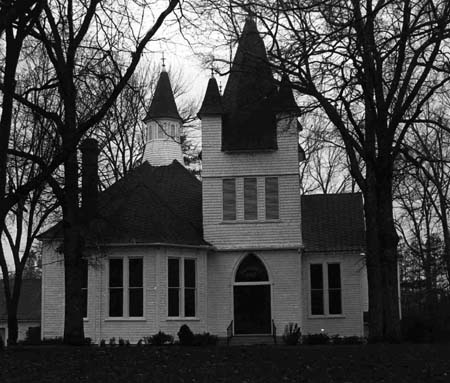
THE HARRISON METHODIST CHURCH


This magnificent building was destroyed by fire on March 17, 1984
This report was written on May 7, 1980.

1. Name and location of the property: The property known as the Harrison Methodist Church is located on U.S. 521 in the southern section of Mecklenburg County, below Pineville, NC.

2. Name, address and telephone number of the present owner and occupant of the property:
The present owner and occupant of the property is:

Harrison Methodist Church
RFD 1 Box 474
Pineville, N.C. 28134

Telephone: 542-3067

3. Representative photographs of the property: This report contains representative photographs of the property.

4. A map depicting the location of the property: This report contains a map which depicts the location of the property.


5. Current Deed Book Reference of the property: The most recent deed to this property is received in Deed Book 1386, Page 315. Tax Parcel Number: 22302104.

6. A brief historical sketch of the property:

Local tradition holds that a Methodist congregation began to assemble for worship near the site of Harrison Church in 1785.1 Initially served by circuit riders, the people gathered in an open air arbor, a type of religious edifice commonly found in eighteenth century Mecklenburg.2 Controversy surrounds the source of the church’s name. About 1775, a group of settlers migrated to the region from the vicinity of Harrisonburg, Va. Among them were Tunis Hood and his wife, Elizabeth Harrison Hood. Their grandson, John Harrison Hood, commonly known as “Harrison Hood,” although a member of Providence Presbyterian Church, donated the land and the logs and provided the slaves to erect the first church building sometime between 1805 and 1815. Consequently, the congregation named the church in honor of their benefactor.3 Another version is that the church acquired its appellation from Samuel Harrison, a prominent Methodist in the community. Indeed, George Washington ate breakfast at Harrison’s home on his journey from Camden, S.C., to Charlotte in June 1791. Also, Bishop Francis Asbury, the father of American Methodism, visited the Harrison community in November 1808.4

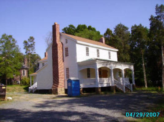
Harrison Methodist Church prospered. Indicative of its strength was the fact that Harrison Church gave rise to four other congregations: Hebron Methodist Church (no longer extant), Pineville Methodist Church, Marvin Methodist Church, and Pleasant Hill Methodist Church.5 In 1844, Harrison joined with other congregations in the South in forming the Methodist Episcopal Church South, in defense of the institution of slavery.6 The 1840’s also witnessed the destruction of the initial church building by fire. A frame building was erected in 1848 to house the Harrison congregation. Despite the agony and economic hardships wrought by the Civil War and the withdrawal of the black members occasioned by that tragic conflict, Harrison Church continued to thrive. The first parsonage was built in 1879.8 On June 30, 1902, the congregation appointed a building committee to oversee the construction of a new house of worship. Work began in the summer of 1902, and the edifice was dedicated in August 1903. It cost $3350.9 This imposing frame building continues to serve the congregation. The main block of the church retains its essential physical integrity. In late 1921, the basement was excavated for Sunday School classrooms.10 An educational wing was added to the rear of the church in 1941.11 A choir loft was installed in 1949 but was removed in 1954 by action of the congregation.12 The property contains three other buildings the parsonage (1950), the Fellowship Building (1954) and the Education Building (1972).13 The Church cemetery is also located on the site. The earliest stones date from 1848.14


NOTES

1 Orion N. Hutchinson, Jr., “A History Of Harrison Methodist Church 17 85-1955,” p. 9 (an unpublished manuscript in the Carolina Room of the Charlotte-Mecklenburg Public Library). Hereafter cited as Hutchinson. If Harrison Church was established in 1785, it is the oldest Methodist congregation which survives in Mecklenburg County.

2 Ibid., p. 10.

3 Ibid., p. 13.

4 Ibid., p. 14.

5 Ibid., pp. 48-49.

6 Ibid., p. 34.

7 Ibid., p. 35.

8 Ibid., p. 52.

9 Ibid., pp. 63-64.

10 “A Brief History Of Harrison Church” in Harrison United Methodist Church, a catalogue of Harrison Methodist Church. Hereafter cited as Brief History.

11 Hutchinson, p. 68.

12 Ibid., p. 69.

13 Ibid., p. 70 & 75. Brief History.

14 Brief History.

7. A brief architectural description of the property: This report contains an architectural description of the property prepared by Laura A. W. Phillips, architectural historian.

8. Documentation of why and in what ways the property meets the criteria set forth in N.C.G.S. 160A-399.4:


a. Special significance in terms of its history. architecture, and/or cultural importance: The Commission judges that the property known as the Harrison Methodist Church does possess special historic significance in terms of Charlotte-Mecklenburg. The Commission bases its judgment on the following considerations: 1) Harrison Methodist Church is probably the oldest Methodist congregation in Mecklenburg County; 2) the church building possesses significance as the finest example of its architectural genre in Methodist congregation in Mecklenburg County, 3) the Church cemetery is an unspoiled survivor from the mid-1800’s.

b. Integrity of design, workmanship. materials. feeling and/or association: The Commission judges that the architectural description included in this report demonstrates that the property known as the Harrison Methodist Church meets this criterion. The Commission draws special attention to the fact that the rural setting of the church is essentially intact.

9. Ad Valorem Tax Appraisal: The Commission is aware that designation would allow the owner to apply annually for an automatic deferral of 50% of the Ad Valorem taxes on all or any portion of the property which becomes “historic property.” The current Ad Valorem tax appraisal of the 18.730 acres of land is $51,510. The current Ad Valorem. tax appraisal of the church is $21,819. The property is exempted from the payment of Ad Valorem taxes. The building contains 3511 square feet of floor space. The land is zoned R15.


Bibliography

“A Brief History Of Harrison Church” in Harrison United Methodist Church, a catalogue of Harrison Methodist Church.

Orion N. Hutchinson, Jr., “A History Of Harrison Methodist Church 1785-1955.” (an unpublished manuscript in the Carolina Room of the Charlotte-Mecklenburg Public Library).

Records of the Mecklenburg County Register of Deeds Office.

Records of the Mecklenburg County Tax Office.


Date of Preparation of this Report: May 7, 1980.

Prepared by: Dr. Dan L. Morrill, Director
Charlotte-Mecklenburg Historic Properties Commission
3500 Shamrock Drive
Charlotte, N.C. 28215

Telephone: (704) 332-2726


Architectural Description
 

The Harrison Methodist Church, located on the west side of U.S. 521 in the rolling countryside south of Pineville, is the third church building of a congregation that was established in 1785. Built in 1902, the present frame building is a whimsical expression of late Victorian aesthetics in church architecture. The plan of Harrison Church is relatively sophisticated with its well-integrated juxtaposition of squares, rectangles and polygons. One enters the church through a set of paneled double doors headed by a lancet-arched stained glass transom bearing the inscription “Harrison 1902.” These doors give entrance to a vestibule which constitutes the base of a three-stage entrance tower.

From the vestibule one enters the sanctuary, a large square room set on the diagonal and oriented toward the pulpit at the southwest corner. The pulpit is enframed by a recessed rectangular area set off from the sanctuary by an arched wall and fronted by a semi-elliptical, turned balustrade. Curved pews set on the inclined plane of the sanctuary floor are divided into two sections by a center aisle. A feature of particular interest in the sanctuary is the large, central ceiling medallion which apparently opens to the belfry above. This delightful sawnwork decorative piece features concentric circles in sawtooth and scallop patterns. On the east side of the sanctuary, a polygonal choir loft projects outward from the main body of the church. Balancing this projection, while not duplicating it, is a rectangular room north of the sanctuary which contributes more seating space to the sanctuary or can presumably be closed off to form a separate meeting room. Decorative interior features are uniform throughout the original part of the church.

Ceilings are sheathed in narrow, beaded boards, while walls are plastered and have a beaded-board wainscot. Doors and windows alike are edged with a modified fluted surround with bulls. eye corner blocks. Memorial windows are arranged in pairs or trios and feature geometrically patterned stained glass in various combinations of blue, rust, gold, pink, yellow and green. The exterior of Harrison Methodist Church displays a visually stimulating arrangement of shapes, patterns and textures. Variety in form is created by the juxtaposition of the square sanctuary with its small rectangular pulpit projection, the polygonal choir loft, the rectangular extension to the sanctuary, the tall rectangular entrance tower, and the octagonal belfry. These are further enhanced by the tripped, gable and polygonal roofs, all of which flair outward in bell-cast fashion at their bases. Not only is there variety in basic roof types, but in scale as well, ranging from the large tripped roof of the main sanctuary to the tiny pyramidal roofs of the corner spires on the entrance tower.

A variety of surface patterns and textures decorates the exterior of Harrison Methodist Church. The main body of the frame church is sheathed in German (or drop) siding, interrupted only by the stained glass windows with their bracketed and paneled friezes. The upper extremities of the building, consisting of the second and third stages of the entrance tower and the belfry above the sanctuary, erupt in decorative shingle work popular during the late nineteenth and early twentieth century. On both tower and belfry, layers of square-cut shingles alternate with bands of sawtooth shingles. The shingles, in turn, contrast in feeling with the smooth-cut louvered vents, terminating both belfry and tower spires are decorative metal finials. Completing the composition and echoing the verticality of the tower and the belfry is the tall brick chimney with corbelled cap located next to the choir loft In 1939 a two-story frame educational wing was added to the right rear of the church. While it is obvious that this was an addition, the simplicity of its design with German siding, tripped roof, 6/6 sash windows, brick interior chimneys and brick foundation does not clash with the main body of the church. Other buildings on the church property include the 1950 brick veneer parsonage south of the church, the 1954 cinderblock fellowship building southwest of the church, and the one-story brick veneer education building erected north of the church in 1972. Farther north is the church cemetery, with earliest marked stones dating from 1848. Surrounding the entire complex are more than seventeen acres of rolling fields and woodlands. A dramatic tree-lined drive leads from the highway to the church.


Harrill-Porter House

HARRILL-PORTER HOUSE

This report was written on January 6, 1982.

1. Name and location of the property: The property known as the Harrill-Porter House is located at 329 E. Kingston Ave. in Charlotte, NC.

2. Name, address, and telephone number of the present owner of the property:
The present owner of the property is:

Mrs. Stella M. Hooks
329 E. Kingston Avenue
Charlotte, NC 28203

Telephone: (704) 334-1592

3. Representative photographs of the property: This report contains representative photographs of the property.

4. A map depicting the location of the property: This report contains a map which depicts the location of the property.

5. Current Deed Book Reference to the property: The most recent deed on this property is recorded in Mecklenburg County Deed Book 4489 at Page 553. The Tax Parcel Number of the property is 123-076-07.

6. A brief historical sketch of the property:

On September 15, 1894, the Charlotte Observer reported that Joseph H. Harrill was building a home in Dilworth, Charlotte’s first streetcar suburb.1 The series of events which led to the creation of Dilworth began on July 8, 1890, when Edward Dilworth Latta (1851-1925), native of Pendleton, S.C., son of a wealthy planter, graduate of Princeton University, and owner of a clothing manufacturing plant in Charlotte since 1883, joined with five associates to establish the Charlotte Consolidated Construction Company, locally known as The Four Cs.2 Dilworth officially opened with a gala land sale that began on May 20, 1891.3 The trolley network, which was installed for The Four Cs by the Edison Electric Company, cost forty thousand dollars.4 The first electric streetcar had departed from Independence Square, the intersection of Trade and Tryon Sts., on May 18, 1891.5 The Four Cs operated two lines, which intersected at the Square. One extended from the Richmond and Danville Railroad Depot on W. Trade St. to McDowell St. on the eastern edge of Charlotte, and the other or main line reached from the Carolina Central Railroad Depot on N. Tryon St. southward to Latta Park, the amusement park in Dilworth.6

The prospects for Dilworth appeared to be bright. The Four Cs sold 78 lots in May 1891. Despite these propitious beginnings Dilworth was not an immediate success. The Four C’s did sell seventeen lots in its streetcar suburb from June 1891 until the end of the year, but the situation deteriorated markedly in 1892. Except for conveying a parcel to the Charlotte Street Railway Company, its trolley subsidiary, The Charlotte Consolidated Construction Company did not exchange any lots in Dilworth during the first nine months of 1892.8 The first breakthrough for The Four Cs occurred on July 24, 1892, when the D. A. Tompkins Company, named for its founder and president, Daniel Augustus Tompkins (1851-1914), announced that it would build the Atherton Cotton Mill just south of Dilworth.9 Even more importantly in terms of Dilworth’s success, the company purchased an entire block in the suburb on February 23, 1893, and erected twenty frame cottages thereon for its mill hands.10 Seven of the Atherton mill houses survive, six on S. Euclid Ave. and one on S. Cleveland Ave. They are the oldest homes in Dilworth.11

The Charlotte Consolidated Construction Company endeavored to attract affluent and middle class residents to Dilworth in the early and mid-1890’s. On March 13, 1893, the Charlotte Observer announced that The Four C’s was contemplating the construction of about thirty-five houses in Dilworth, to be “purchased on the building and loan plan.”12 In June 1893, the newspaper stated that these new residences were keeping a “number of hands busy.”13 A cluster of modest Victorian cottages in the Eastlake style did appear on the northern or “upper” end of South Boulevard and on Caldwell Street southward from Morehead Street.14 Only one of these structures survives, at 1032 South Caldwell Street.15 In 1894 The Four Cs succeeded in enticing more affluent families to Dilworth. No doubt the establishment of electric service for homes and the completion of a sewerage system were important factors in creating this phenomenon.16

The most pretentious abodes in the suburb were located on South Boulevard between Park Avenue and East Boulevard, on Park Avenue between South Boulevard and Lyndhurst Avenue, and on Kingston Avenue between South Boulevard and Lyndhurst Avenue. At least four of the earliest homes in the section are extant; they are the Jones-Garibaldi House (1894) at 228 E. Park Ave., the Lucien Walker House (1894) at 328 E. Park Ave., the Mallonee-Jones House (1895) at 400 E. Kingston Avenue, and the Harrill-Porter House at 329 E. Kingston Ave.17 The Harrill-Porter House exhibits features, such as gables decorated with simple scroll-sawn bargeboards, large vents with scroll-sawn trim, and diagonal boarding, which one finds in older center-city neighborhoods, such as the Fourth Ward. It is important to note that the Harrill-Porter House is unique among the older homes in Dilworth in this regard, at least in the finer residential section.

Joseph H. Harrill worked for A. H. Porter & Son, a shoe store and men’s clothing outlet on W. Trade St. in Charlotte.18 Mr. Harrill and his family lived in the house until October 1897, when they moved back into Charlotte and resided on W. Tenth Street in Fourth Ward.19 On September 10, 1898, A. H. Porter, Mr. Harrill’s employer, bought the house, and soon thereafter his son and business associate, Augustus C. Porter (1873-1959) moved into the home.20 A. C. Porter and his wife, Edna Davis Porter (1875-1952) acquired the house on July 26, 1905, and lived there until the 1950’s.21 A native of Farmville, Va., A. C. Porter worked in the shoe business until his retirement in 1946, first for his father, who came to Charlotte in 1897 but returned to Virginia by 1902, and thereafter for the International Shoe Company. He was a member of Pritchard Memorial Baptist Church on South Boulevard in Dilworth, where he served as a Deacon and as Superintendent of Sunday Schools.22 Edna Davis Porter was also a native of Farmville, Va. The daughter of William C. Davis and Flora Brightwell Davis, she married A. C. Porter in 1892 and came with him to Charlotte in 1897.23 Mr. and Mrs. Porter had three daughters, the last of whom, Lorna, was born in the house in 1898.24 Mrs. Porter died on April 7, 1952, in her home on E. Kingston Avenue.25

Soon thereafter, Mr. Porter, who lived until August 5, 1959, sold the house and moved to his daughter’s residence on Dilworth Rd. East in Dilworth.26 The new owner was Robert D. Alexander, president of the Allright Charlotte Company, who lived in the house for approximately one year.27 In July 1954 Mr. Richard Kaye, an employee of Ivey’s Department Store bought the residence, and in 1957 he converted the house into two apartments, one upstairs and one downstairs.28 In August 1960, Mr. Kaye sold the residence to John and Bessie Carabateas, who converted the house into four apartments. Mr. Carabateas died in 1965, but his widow continued to manage the structure until July 1966, when she sold the house to William Plemmons and his sister, Blanche P. Gudger.29 They operated the structure as an apartment house until 1981, when the house was damaged by fire. Mrs. Stella M. Hooks has recently purchased the structure, and she intends to repair and restore it as her residence.


NOTES

1 Charlotte Observer (September 15, 1894).

2 Charlotte News (June 27, July 9, 1890). Latta’s partners in creating The Charlotte Consolidated Construction Company were F. B. McDowell, E. B. Springs, Dr. M. A. Bland, E. K. P. Osborne, and J. L. Chambers, all Charlotteans.

3 Charlotte News (May 21, 1891).

4 Charlotte News (February 12, 1891).

5 Charlotte News (May 19, 1981); Morning Star (Wilmington, NC, May 22, 1891).

6 Charlotte News (March 19, April 23, May 23, 1891).

7 Records of the Mecklenburg County Registrar of Deeds Office.

8 Ibid.

9 Charlotte Observer (July 24, 1892).

10 Mecklenburg Deeds, Book 90, Page 310.

11 Ruth Little-Stokes, “Dilworth Historic District: Charlotte, N.C. Architectural Analysis,” 1978. Hereafter cited as Little-Stokes.

12 Charlotte Observer (March 13, 1893).

13 Charlotte Observer (June 17, 1893).

14 Charlotte Observer (April 6, 1894).

15 Little-Stokes.

16 Charlotte Observer (September 30, December 4, 1894).

17 Charlotte Observer (September 8, 1894); Little-Stokes.

18 Charlotte City Directory 1896-97, p. 177.

19 Charlotte Observer (October 12, 1897).

20 Mecklenburg Deeds, Book 202, Page 67; United State Census 1900, Charlotte Township, p. 9A; Charlotte City Directory 1899, p. 116.

21 Mecklenburg Deeds, Book 200, Page 437; Kat Braswell, “A Structural Survey Form For the House at 329 E. Kingston Ave.” (prepared for a Historic Preservation Course at the University of North Carolina at Charlotte, 1979), hereafter cited as Braswell.

22 Charlotte Observer (August 6, 1959); Charlotte City Directory 1902, p. 492.

23 Charlotte Observer (April 8, 1952); United State Census 1900, Charlotte Township, p. 9A.

24 Braswell.

25 Charlotte Observer (April 8, 1952).

26 Mecklenburg Deeds, Book 1551, Page 371; Charlotte Observer (August 6, 1959); Braswell.

27 Braswell.

28 Mecklenburg Deeds, Book 1685, Page 105; Braswell.

29 Mecklenburg Deeds, Book 2165, Page 405; Mecklenburg Deeds, Book 2770, Page 597; Braswell.


7. A brief architectural description of the property: This report contains an architectural description of the property prepared by Thomas W. Hanchett, Architectural Historian.

8. Documentation of why and in what ways the property meets the criteria set forth in N.C.G.S. 160A-399.4:


a. Special significance in terms of its history, architecture and/or cultural importance: The Commission judges that the property known as the Harrill-Porter House does possess special historic significance in terms of Charlotte-Mecklenburg. The Commission bases its judgment on the following considerations: 1) the Harrill-Porter House is one of the few pre-1900 houses which survive in Dilworth, Charlotte’s first streetcar suburb; 2) the house is a unique example among the more imposing homes of Old Dilworth in that it displays vernacular motifs and details which one finds in Fourth Ward; and 3) the house is strategically important in terms of townscape because it is situated on a corner lot and anchors an entire intact streetscape.

b. Integrity of design, setting, workmanship, materials, feeling and/or association: The Commission judges that the architectural description included herein demonstrates that the property known as the Harrill-Porter House meets this criterion.

9. Ad Valorem Tax Appraisal: The Commission is aware that designation would allow the owner to apply annually for an automatic deferral of 50% of the Ad Valorem taxes on all or any portion of the property which becomes “historic property.” The current Ad Valorem tax appraisal on the Harrill-Porter House is $6,740. The current Ad Valorem tax appraisal on the .161 acres of land is $2,500. The most recent Ad Valorem tax bill on the house and land was $166.50. The house contains 3,382 square feet. The land is zoned R6MF.


Bibliography

Kat Braswell, “A Structural Survey Form For the House at 329 E. Kingston Ave.” (prepared for a Historic Preservation Course at the University of North Carolina at Charlotte, 1979).

Charlotte City Directory, 1896-97; 1899; 1902.

Charlotte News.

Charlotte Observer.

Ruth Little-Stokes, “Dilworth Historic District: Charlotte, N.C. Architectural Analysis,” 1978. Morning Star (Wilmington, NC).

Records, of the Mecklenburg County Register of Deeds Office.

Records of the Mecklenburg County Tax Office.

United States Census 1900.


Date of Preparation of this Report: January 6, 1982.

Prepared by: Dr. Dan L. Morrill, Director
Charlotte-Mecklenburg Historic Properties Commission
3500 Shamrock Dr.
Charlotte, NC 28215

Telephone: (704) 332-2726


Architectural Description


by Thomas W. Hanchett

The Harrill-Porter House is a substantial two story late Victorian home on a corner lot. It anchors a block of large, closely spaced homes from the late 1890s to the 1910s, a strong streetscape that survives intact except for one demolition at the opposite end of the block. The house in its prominent corner location serves to tie this block to similar homes in adjoining blocks of Kingston and Euclid Avenues. The massing of the house is relatively complex, showing influence of the Queen Anne style which was at its peak when the home was built in 1894-95. The basic block of the building is a two story hip-roofed rectangle three bays long and two bays deep. Two brick chimneys poke through the east and west sides of the roof. The top of the east chimney has been clumsily rebuilt, but the simple corbeled cap of the west one remains. Four gable-roofed two story wings, each one bay wide, jut out from the main block, one on each side of the house. Gables are decorated with simple scroll-sawn bargeboards, large vents with scroll-sawn trim, and diagonal boarding. Eaves are narrow and simply boxed with no decorative elements.

The walls of the house are clapboard with beaded corner boards. Windows are two-over-two pane double-hung sash in plain surrounds. The front door is trimmed with wide fluted molding and bull’s eye corner blocks, a common Victorian motif. The first story front windows extend from floor to ceiling under the porch. The one story porch wraps around the south (front) and east sides of the building. It is shed-roofed except for a small gable with scroll-sawn bargeboards that marks the entrance. The east side of the porch was walled in to create a sun porch, probably in the first decades of this century. On the remainder of the porch the original balustrade railing and turned porch columns are still visible, though the original balusters have been removed. Concrete steps and walk dating from the early twentieth century lead up from the sidewalk to the porch.

A low concrete wall from the same period contains the small front yard, raising it about two feet above the public sidewalk, once a common feature of better Charlotte homes. The foundation of the building is brick. There is evidence that the house originally rested up off the ground on brick piers, a common southern practice, and that the spaces between the piers were later bricked in. Under the home only enough area has been excavated for a furnace room. To the rear of the house are several additions. The two major ones are a one story gable-roofed kitchen wing, which may date back the original construction of the house, and a two story shed-roofed sleeping porch at the northeast corner that probably dates from the l910s-1930s when such porches were popular. Entering the home through the front door one is in a long, relatively narrow hallway, a feature more typical of the mid nineteenth century than of this period. A straight run of stairs rises from the rear of this hall back toward the front of the house, giving access to the second floor. Its massive newel post remains in good condition. In the main block of the house there are two major rooms on each side of this central space on each floor. Victorian era mantels survive in several rooms, as do many of the original wood panel doors. Beyond this there is little decorative woodwork. The house was heavily damaged by fire in summer, 1981. Most damage was confined to the attic, the upper stairwell, and the rear rooms of the second floor.


Hand Pharmacy

OLD HAND’S PHARMACY BUILDING


This report was written on August, 1986

1. Name and location of the property: The property known as the Old Hand’s Pharmacy Building is located at 3201 N. Davidson Street, Charlotte, North Carolina.

2. Name, address, and telephone number of the present owner of the property:
The owner of the property is:
Mr. Frank R. Hand
2900 Whiting Ave.
Charlotte, N.C. 28205

Telephone: 704/332-5529

3. Representative photographs of the property: This report contains representative photographs of the property.

4. A map depicting the location of the property: This report contains a map which depicts the location of the property.

5. Current Deed Book Reference to the property: The most recent deed to this property is recorded in Mecklenburg County Deed Book 246, p. 343. The Tax Parcel Number of the property is: 083-084-10.

6. A brief historical sketch of the property: This report contains a brief historical sketch of the property prepared by Dr. William H. Huffman.

7. A brief architectural description of the property: This report contains a brief architectural description of the property prepared by Nora Mae Black.

8. Documentation of why and in what ways the property meets the criteria for designation set forth in N.C.G.S. 160A-399.4:


a. Special significance in terms of its history, architecture, and/or cultural importance: The Commission judges that the property known as the Old Hand’s Pharmacy Building does possess special significance in terms of Charlotte-Mecklenburg. The Commission bases its judgment on the following considerations: 1) the Old Hand’s Pharmacy Building, erected ca.1912, was an important component of the commercial district of North Charlotte, one of Charlotte’s most important mill communities; 2) the Old Hand’s Pharmacy Building is one of the best-preserved examples of brick commercial architecture of the early twentieth century in Charlotte-Mecklenburg, and 3) the Old Hand’s Pharmacy Building is one of the most important buildings in terms of the historic streetscape of North Davidson Street, because it occupies a corner lot at a major intersection.

b. Integrity, design, setting, workmanship, materials, feeling, and/or association: The Commission contends that the architectural description included in this report demonstrates that the property known as the old Hand’s Pharmacy Building meets this criterion.

9. Ad Valorem Tax Appraisal: The Commission is aware that designation would allow the owner to apply for an automatic deferral of 50% of the Ad Valorem taxes on all or any portion of the property which becomes “historic property.” The current appraised value of the improvement is $16,950. The current appraised value of the land is $4,920. The total appraised value of the property is $21,870. The property is zoned B1.

Date of Preparation of this Report: August, 1986
Prepared by: Dr. Dan L. Morrill
Charlotte-Mecklenburg Historic Properties Commission
1225 S. Caldwell St. Box D
Charlotte, N.C., 28203

Telephone: 704/376-9115


Historical Overview


The Hand’s Pharmacy Building, located on the northwest corner of 35th and N. Davidson Streets, is one of the original brick commercial buildings in the North Charlotte community, and for many years housed both a pharmacy and community meeting place. Jasper Kennedy Hand (1878-1947), who had the pharmacy building constructed about 1912, was a Gaston County native, the son of Samuel end Catherine Lineberger Hand. The Gaston town of Lowell was his early home, end he attended Davidson College and the Pharmaceutical School at the University of North Carolina.1 Since his career was established, in 1902 he was married to Erwin Robinson (1881-1977), who was also from Lowell. Five years later, J. K. Hand decided to locate in Mecklenburg, and so in July, 1907, he bought Froneberger’s Drug Store on North Caldwell (now Davidson) Street in the North Charlotte community.2 The development of North Charlotte, which is located about two and a half miles northeast of the Square, began in 1903, and was tied in with the expansion of textile manufacturing in Mecklenburg County from the 1880s to the 1920s, during which time the county ranked variously second or third in textile production in the state.

In 1903, the Charlotte textile entrepreneurs William E. Holt, Jesse S. Spencer, and Charles W. Johnson built the Highland Park Mill No. 3 on what was open farmland and some of the city’s reservoir system along sugar Creek. It was located on the Southern Railway tracks just over two miles from the city center, and was not only the county’s largest mill, but was probably one of the first mills in the state designed to be electrically driven. Across from the mill the owners built a large mill village, complete with houses, churches, a school and hotel; and the County Poorhouse grounds on 36th Street were made over into a recreational park (the road leading there from town used to be called Poorhouse Rood, then the County Home Road).3 Shortly after work began on Highland Park No. 3 in 1903, an heir to the Duke tobacco fortune, B. Lawrence Duke, and Charlottean Robert L. Tate bought a site from Highland Park and began construction of a smaller plant, the Mecklenburg Mills, just to the north along the railroad track on the other side of Caldwell, now Davidson Street. Another mill village was put up to accommodate the workers. The last mill built in the area was the Johnston Mill in 1913, which was under the ownership of C. W. Johnson.4

By 1904, as the first two North Charlotte mills and their company-owned houses were nearly finished, enterprising merchants were already beginning to establish businesses along the main road, Caldwell street, between the present 34th and 36th Streets.5 When J. K. Hand bought Froneberger’s Drugstore in 1907, it was in a wood-frame building located on the same side of the street and one block south of his later two-story brick store.6 Apparently wanting a better and more permanent structure for his business, in 1909 Hand bought a corner lot which then was on the northeast corner of North Caldwell and 31st Streets, which had fifty and one-half feet of frontage on Caldwell and was ninety feet deep.7 About three years later, ca. 1912, Harvey C. Garrison, a local contractor, was hired to construct the building, and it may have been the case that he designed it as well. By 1915, the Hands moved into a handsome one-year old house at 2900 Whiting Avenue, where, two years later, their only son, Frank R. Hand, who still lives in the residence, was born.6

The building was really twice as large as Hand needed for his pharmacy, but he envisioned that the second floor, which has a separate outside stairway entrance, would be used as a community meeting place, a brotherhood hall. Since there were also facilities available elsewhere, the second floor was mostly used for light storage, and, for many years, a local physician, Dr. McClosky, practiced medicine there in waiting and examining rooms in the front of the buiiding.9 The pharmacy itself was located entirely on the first floor, and contemporary photographs show a typical small-town drug store building from the exterior: plain storefront windows with painted Pepsi-Cola, slogans written in script at the top, which were bracketed by the words “Drugs” and “Soda.” The interior fixtures were all oak or marble, not fancy, but certainly substantial. Merchandise was neatly laid out in glass wall cabinets and display cases along the south wall and back half of the north. Along the front half of the north wall was the marble soda fountain, which had a large “Hires Root Beer” barrel and three glass candy jars on it. In the back, two tables with four chairs each were available for soda fountain patrons. Just under the pressed tin ceiling, posters decorated the store all the way around. One announced, “Jonteel Compacts: Face Powder in Handy Form;” another showed a picture of a camera and said, “Kodak as you go.” Of the three in the back of the store, one was titled “Prescriptions,” and showed a kindly pharmacist dispensing medicine for a mother and her child, while the one on the right proudly trumpeted “Rexall means King of All.”10

In such a small community, Hand’s Pharmacy was important to the very fabric of its daily existence. Not too long after it was established in North Charlotte, however, Gamble Drugs opened across the street, and both concerns struggled for many years in competition for the relatively small amount of business in the community. During the Depression, it was common for Hand to go for long periods without being paid for drugs and remedies he dispensed, if he was ever paid at all.11 For thirty-eight years, J. K. Hand provided service and merchandise for North Charlotteans through the ups and downs of two world wars, the Great Depression, mill layoffs and strikes. On V-J Day, 1945 (victory over Japan, the day of its surrender ending World War II on August 14). Hand sold the business to John D. Dover, who had previously worked in the store. A few years later, it become Dorton’s Drug Store, and finally the North Charlotte Pharmacy until 1978. Since that time, the building has housed various tenants, but none were related to the drug store business.12 For many years, the Hand’s Pharmacy Building was one of the solid landmarks of the center of the North Charlotte community. Its past role is worthy of recognition, and its future role in a revived community is worthy of accomplishment.


NOTES

1 Charlotte Observer, April 5, 1947, Sec. A, p. 7.

2 Interview with Frank R. Hand, Charlotte, NC, 2 August l986.

3 Thomas Hanchett, Charlotte and Its Neighborhoods, unpaginated, unpublished typescript.

4 Ibid.

5 Ibid.

6 Interview with Frank Hand.

7 Deed Book 246, p. 343, 20 April 1909.

8 Interview with Frank Hand.

9 Ibid.

l0 Photographs supplied by Frank R. Hand.

11 Interview with Frank Hand.

12 Ibid.


ARCHITECTURAL DESCRIPTION


The Jasper K. Hand Pharmacy Building, located on the north corner of the intersection of North Davidson Street and 35th Street, is an architecturally distinguished example of the privately-owned buildings that formed a commercial district to serve residents of north Charlotte during the beginning of this century. At the time of construction, the pharmacy stood alone on its corner; however, Jasper Hand had the building which abuts the northeast wall of the pharmacy constructed later and leased it to other neighborhood businesses. No other buildings are connected to the pharmacy and no additions have been made to it. The Hand Pharmacy was constructed in 1912 by Harvey Edgar Garrison. The basement was excavated using mules and drag pans. The building, 22 feet wide by 70 feet long, is of masonry and timber construction. In recent years, a steel beam was added in the basement. Running the length of the building, it was used to shore up the massive timbers that supported the first floor.

Mr. Hand continued to operate the pharmacy on North Davidson Street until August 14, 1945, when he sold the business as well as the furnishings and fixtures. However, he retained ownership of the building. The building consists of three floors. The basement was used as a service area and for storage of coal. The first, or street-level, floor housed the pharmacy. The second floor provided a large meeting hall for organizations within the north Charlotte community. The Hand Pharmacy has a two story facade on North Davidson Street of pressed, or face, brick. The dark brown brick was joined with mortar colored to compliment it. The brickmason added a row of corbels of the same dark brown brick about one foot below the roofline of the facade to form a cornice. At either side of the facade there are longer corbels. The corbels project about six inches from the wall giving it a sense of depth and rich detail. The one-story center entrance on North Davidson Street is recessed four feet from the facade. One step up from the sidewalk, it is paved with red clay tiles. Formerly, a canvas awning at the level of the first floor ceiling could be extended over the sidewalk to give shade to the show windows and the horizontal row of stationary windows above the transom.

The canvas awning has been replaced by a horizontal metal awning below the transom while the windows above the transom have been covered with an aluminum panel. The glass show windows, framed in aluminum, are approximately seven feet high set on a brick ledge that is approximately two feet high. They are replacements for the original windows which were framed in bronze. Modern standard double glass doors have replaced the original entry doors of walnut with beveled glass panels. The red brick beneath the show windows was used to repair the facade after an automobile accident on July 4, 1953. On the second story portion of the facade, there are three large windows which have been covered with translucent fiberglass panels to prevent further breakage of the window panes. A portion of one sign from a recent tenant hangs over the Davidson Street sidewalk on the 35th Street corner of the building. Otherwise there are no signs painted on or attached to the building. However, the North Davidson Street facade has several small scars caused by the attachment of signs, electrical service and awnings. Utility brick, laid in common bond; was used for the side walls and the rear wall. There are six large windows on each side wall of the second floor. Across the back of the building there are three large windows on both the first and second floors. All of the large rectangular windows (including the three on the second floor, front facade) have flat masonry arches, usually called jack arches, and brick ledges. All of the side and back windows have been covered with one piece panels of either ribbed aluminum or translucent ribbed fiberglass panels. In addition to the panels, the windows on the first floor rear wall have iron bars over them.

The original windows, double hung with wooden sashes, are behind the panels. However, much of the glass has been broken. Double wood paneled doors were used as a service entrance for the first floor. Located near the rear (northwest) corner of the building on the 35th Street side, they had neither steps nor a platform. There are four basement windows, two on either side of the basement door, on the 35th Street side. The lot slopes away from that side of the building allowing the windows to provide light for the dirt-floored basement; however, the windows had to be bricked up because of water seepage and break-ins. The windows have segmental masonry arches of two rowlock courses. The window closest to the corner of North Davidson Street and 35th Street was used as a coal chute with the coal for the heaters being stored in the front section of the basement. Concrete steps lead down to a bricked well with a wooden door with a segmental masonry arch. The basement was only used as a storage and service area because of dampness. In fact, Jasper Hand had the first two or three steps of an interior stairway beginning on the first floor built, but then he closed up the opening and never finished the stairway. The side walls are stepped down in four equal steps to follow the slope of the roof with the highest part of the roof being parallel to North Davidson Street. The roof is supported by unpainted wooden rafters and wooden sheathing.

A metal gutter with one downspout runs across the rear wall. The original metal standing seam roof was badly damaged by a storm during World War II. After further damage in another storm, the roof was replaced with a built-up roof. However, a few leaks have caused some interior water damage that is apparent in the rear portion of the second floor. Some plaster has fallen from the walls and part of the floor has been covered with black water-proofing material. A metal cantilevered stairway leads to double wooden panel doors on the second floor. Originally one big meeting room, the second floor has been partitioned at the rear and at the front. The rear partition secludes an area of water damage. The partition at the front, parallel to North Davidson Street, provides a space that was subdivided into two smaller rooms. The two rooms served as an office and examining room for Dr. Joseph Hamilton McLeskey about the time of the depression. The second floor has pine flooring, painted plaster walls and a tongue and groove ceiling. Some of the original light fixtures still hang from the ceiling. Several built-in flues for heaters have now been closed to prevent water damage. Without the two partitions, the second floor would look much as it did in 1912 with one major exception. A gas system, providing heat and air conditioning, has been installed in the center of the second floor. The ductwork extends radially from the system. Several holes have been cut in the floor to pass ducts to the first floor. Some partitions have been added on the main floor since the building is now used for offices rather than a pharmacy. In 1912, the main floor would have appeared quite large since it had only one nine foot high partition near the rear of the building.

Beneath several layers of flooring material, there is a floor of hardwood. Probably birch, it was cleaned with oiled sawdust and a pushbroom in the early days of the Hand Pharmacy. The stamped tin ceiling was installed when the building was constructed. The ceiling, approximately 15 feet high, is painted white. It had been damaged by a fire in 1977 (which incurred no structural damage to the building) and again when holes were cut in it for the ducts mentioned earlier; however, after the 1977 fire, the building underwent major refurbishing. Few of the building’s original fittings have survived. However, one of Jasper Hand’s original utility tables is stored on the second floor along with several drawers from one of his cabinets. The Jasper K. Hand Pharmacy Building provides a solid architectural presence at the corner of North Davidson Street and 35th Street. Since so much of the original fabric is unchanged and in relatively good condition, it could be rehabilitated and adapted for reuse as a landmark building in a revitalized north Charlotte neighborhood.


NOTES

Frank R. Hand, son of Jasper K. Hand, was kind enough to be interviewed by telephone and to give the author a tour of the building as well. The historical notes are based on his recollections.