Charlotte-Mecklenburg Historic Landmarks Commission

Author: Mary Dominick

Caldwell Station School

  1. Name and location of the property: The property known as Caldwell Station School  is located at 17616 Caldwell Station School Rd, Huntersville, N.C.
  2. Name, address, and telephone number of the current owner of the property:

Preschool Inc.

17616 Caldwell Station School Rd.

Huntersville NC 28078

  1. Representative photographs of the property:  This report contains representative photographs of the property.
  2. A map depicting the location of the property:
  3. Current Tax Parcel Reference and Deed to the property:    The tax parcel number of the property is 01103203.  The most recent deed to this property is recorded in Mecklenburg County Deed Book 8782 page 595 (10/17/1996).  UTM coordinates are 514343.2 E and 3923113.7N
  4. A brief historical sketch of the property:  This report contains a brief historical sketch of the property prepared by Stewart Gray.
  5. A brief architectural description of the property:  This report contains a brief architectural description prepared by Stewart Gray.
  6. Documentation of why and in what ways the property meets the criteria for designation set forth in N.C.G.S 160A-400.5. 
  7. Special significance in terms of its history, architecture and/or cultural importance: The Commission judges that the property known as the Caldwell Station School  possesses special significance in terms of Charlotte-Mecklenburg.  The Commission bases its judgment on the following considerations:

1) The Caldwell Station School is a well preserved example of early 20th century rural school architecture in Mecklenburg County.

2) The Caldwell Station School demonstrates the rapid evolution of rural schools in Mecklenburg County in the first half of the 20th Century from widely scattered small schoolhouses into larger “union” schools located in the county’s towns.

3) The Caldwell Station School is the most substantial surviving building associated with the place known as “Caldwell Station” a small rural commercial and transportation center with origins that can be traced to the 1850s.

4) The Caldwell Station School is important for understanding the history of Mecklenburg County in that it vividly demonstrates the nature of rural schools in the county during the first half of the 20th Century

  1. Integrity of design, setting, workmanship, materials, feeling and/or association: The Commission contends that the architectural description prepared by Stewart Gray demonstrates that the property known as the Caldwell Station School meets this criterion.
  2. Ad Valorem Tax Appraisal:  The Commission is aware that designation would allow the owner to apply for an automatic deferral of 50% of the Ad Valorem taxes on all or any portion of the property which becomes a “historic landmark.”  The current appraised value of the school building is $33,100.  The current appraised value of the 1.08 acres of land is $62,300.  The property is zoned R.  The property is exempt from the payment of Ad Valorem Taxes.
  3. Portion of the Property Recommended for Designation.  The school building and the 1.08 acres of land associated with tax parcel number 01103203.


A Brief History of the Caldwell Station School

Caldwell Station

Commercial and civic development in the area known as Caldwell Station predates the introduction of the railroad into northern Mecklenburg County.  Andrew Springs  built a fine plantation house there before the Civil War when the place was called “Hickory Grove.”  Chalmers Davidson describes Hickory Grove in his book The Plantation World Around Davidson and in this book notes that Springs operated a store and ran a post office.  Springs is listed as Post Master at “Hickory Grove” in Mecklenburg County in an 1842 listing of post offices. (1)

Above photograph of Hickory Grove was taken as part of the Historic American Buildings Survey (HABS) in 1934

How the area came to be called Caldwell is unclear.  The place is less than two miles from another large plantation, Glenwood, which was owned by D.A. Caldwell.  Andrew Springs’s daughter Mary married D.A. Caldwell’s brother Major John Caldwell so it is possible that members of the Caldwell family lived at Hickory Grove.(2)  After the Civil War, the name Hickory Grove is no longer used, and the area is know as some version of the name Caldwell. The importance of the place surely increased with the completion of the Atlantic, Tennessee and Ohio Railroad between Charlotte and Davidson (then called Davidson College)  in 1861. While the railroad line was removed during the Civil War, service was restored to Davidson by 1873. (3) That same year a post office was reestablished at Caldwell. (4) The name “Caldwell’s” is listed as a train stop between Hunter’s (later Huntersville) and Davidson College in the 1878 “Hassan’s American and European Distance Tables”  A map dated 1881 of North Carolina and South Carolina identifies the place as “Caldwells.” (5) The Chas. Emerson & Co. Charlotte City Directory 1879-1880 lists “Caldwell” among the county’s villages and lists three men named Caldwell among the village’s “Business Men…and the Principal Farmers.”  Other villages listed include familiar names like Matthews, Paw Creek, and Huntersville, as well as now forgotten names like Hebron, Harrison, Irene, and Mutual Love.   By 1895 there was a one-teacher school in Caldwell.  The 1912 Rand-McNally “New Commercial Atlas Map of North Carolina” identifies “Caldwells” as a town with a population of thirty.

Page from Chas. Emerson & Co. Charlotte City Directory 1879-1880

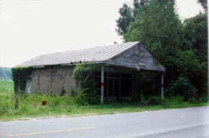
Why Caldwell did not survive as a discernable community is unclear.  The emergence of the nearby town of Cornelius was the most likely cause.  Cornelius is located at an important crossroads connecting the Statesville Highway (now highway 115)  with Lincoln County and other places to the west.  The town began with cotton trading around 1888; and in 1891 Richard Stough and his brother-in-law, Mr. C. W. Johnston (who later built the Johnson Mill in Charlotte) incorporated a cotton mill at the location, naming it the Cornelius Cotton Mill after their largest investor Joe Cornelius. The town grew quickly.  In 1899 Cornelius opened a post office.  Until then, mail for Cornelius was picked up at the Caldwell Post Office.  The town of Cornelius was incorporated in 1905, and a school opened in Cornelius in 1906. (6) The post office in Caldwell closed in 1904.  Trains continued to stop at Caldwell for passengers and freight, and the area began to be referred to as Caldwell Station. By 1938 aerial photographs indicate minimal development around the Caldwell Station area.  A pre-war gas station was extant in the neighborhood until it was recently demolished.  A concrete railroad platform along with the school building are now the only indication that Caldwell Station was once a rural commercial and civic center.

View of the Caldwell Station area looking north

The Caldwell Station School

Mecklenburg County citizens voted in 1880 to establish a graded public school system.  This may have been in response to a high illiteracy rate in the 1880s.  North Carolina ranked lower in literacy than all of the other states in the Union except South Carolina. (7) The early products of this vote in northern Mecklenburg include the 1890 Croft Schoolhouse and the ca.1890 Rural Hill School.  The Caldwell Station School was established sometime before 1895.  An 1895 photograph shows a frame building with approximately thirty children posed before the building.

Beginning in 1885 the Mecklenburg County Board of Education was ultimately responsible for the education of the children in the unincorporated sections of the county, and for students in some of the small towns (the city of Charlotte and the town of Davidson both operated their own schools).  For the larger schools, such as the Huntersville School with 457 students in 1925, or the Cornelius School with 460 student, the board was directly involved in decisions concerning the development and operation of the schools. Among hundreds of decisions in 1925, the Board voted to purchase twelve railcar loads of Coal for the larger schools, to direct architect Louis Asbury to choose tile and brick for the new Steele Creek School, and they voted to oppose the teaching of evolution.  However, from the late 19th century through the 1920s, most of the decisions concerning the county’s small rural schools were delegated to local committees. These committees hired the teachers and built and maintained the schoolhouses.  The rural communities in Mecklenburg County had to petition the Board of Education before building a new school; but once completed, the school was operated by the local residents. (8)  This autonomy began to erode as the 20th century progressed.  State laws that provided funding and the power to tax for public schools were enacted in 1901 and 1907.  In 1913 a compulsory attendance law was passed that required all children between the ages of eight and twelve to attend at least four months of school.  In 1919 that was raised to six months.  As public education expanded in the state, educators began to push for the consolidation of schools.  Educators believed that one-room or one-teacher schools did not serve the students as well as “graded” schools.  A vote in 1911 allowed education tax money to be used for transportation, and by the 1920s buses in Mecklenburg County were enabling consolidation of the smaller schools. (9)

The consolidation movement was played out in northern Mecklenburg in July of 1924 when the Board of Education approved a twenty-five cent levy on every $100 of property value in the Caldwell Bradford School district and required that students from the one-teacher school be bused to the Caldwell Station School.  The school term for the school would be eight months, and students would be educated through the sixth grade.  Beyond the sixth grade students would be bused to the high school in Huntersville.  (10)  The action turned the Caldwell Station School into a “union” school.

The Board instructed the school superintendent, Plummer Stewart, to “confer with the local committees with reference to additional rooms at Caldwell Station.”  Apparently, additional rooms on the old building did not appear to be feasible. In March of 1925 the Board directed the superintendent to work with the local committee from Caldwell Station on the erection of a “new house.”  Will Knox is attributed with building the new schoolhouse. (11)  Knox was a builder, farmer, and a member of the Caldwell Station School Committee.  Knox probably led a community effort to build the building using volunteers and perhaps donated material.  The nearby Mallard Creek School was constructed quickly using the same approach in 1920. (12)   It appears that the new two-room Caldwell Station School building was ready for the beginning of the school year in the fall of 1925, because the Board of Education had approved in August of that year the use of the old Caldwell Bradford Schoolhouse by a women’s community club.   The new school featured two rooms separated by a removable partition.  The building had no electricity and the classrooms were illuminated by large banks of windows.  The building had no plumbing and was heated by two woodstoves.

When the Caldwell Station School opened in 1925 there were forty-eight students enrolled.  That was larger than the nearby schools at Fidler (31 students), Bethel (32), or Alex-Iredell (38).  But it was a much smaller enrollment than that of the Cornelius (460)  and Huntersville (457) schools, which featured classes for grades one through eleven. (13) Wilson Knox began attending the Caldwell Station School in 1929 when he was in the third grade.  He recalls that the two teachers were Miss Marie Vance and Miss Martha Millan.  Students in grades one through three were educated in one classroom, with grades four through six in the other room.  Knox remembers that an older student, Willie Nance, built the fires in the two woodstoves, and that one day as a prank someone stuffed the flue pipe full of newspaper.  When Nance lit the fire, smoke filled the building.  Water was drawn daily from a pump at the neighboring home of Chalmers Knox, and the boys were responsible for bringing the water to the classrooms.  Children brought their lunches.  While some students arrived by bus, many walked.  Nell Washam Caldwell only attended the school for one year but remembers a large boiler from a nearby abandoned mill or factory that the children played on. (14) Train traffic was busy in front of the school, and Wilson Knox remembers that there was a primitive passenger shelter near the school.


Ca. 1929 Photograph of Caldwell Station School

Even with the consolidation of the schools progressing, there was still considerable diversity among the rural schools, perhaps reflecting the continued autonomy of the local school committees.  While the school term at the Caldwell Station School lasted eight months, the nearby Gilead and McDowell schools kept a seven month calendar.   Unlike the six grades at Caldwell Station, the four-room Mallard Creek School offered classes through the seventh grade.  Caldwell Station students were bused to Huntersville for high school.  It was different at Mallard Creek.  In 1926 the Board of Education gave Mallard Creek parents the option of stopping education at the seventh grade, paying individually to attend Huntersville High School, or instituting a new tax levy of fifteen cents to cover the cost of attending the higher grades.  (15)

This diversity of rural elementary schooling in Mecklenburg County began to end as the Board of Education voted to close more of the rural schools.  In 1927, just two years after the Caldwell Station School was built, the Board voted to discontinue elementary education at both the Caldwell Station and Mallard Creek schools.  This process took until 1931 to complete, and the Caldwell Station School continued to operate.  Farmer J. W. Washam was selected as the Board’s committeeman in 1928.  He was replaced by W. M. Know in 1929, and the last committeeman was G. R. Mayes who was appointed in 1930.   During the 1930-31 school year the sixth grade students from Caldwell Station attended the unified Huntersville School.  Nell Caldwell remembers that with an odd number of grades, the third-graders would start with one teacher, and then move to the other classroom in the afternoon.  In the spring of 1931 no new committee appointments were made for the Caldwell Station School, and on August 1, 1931 it was reported to the board that “the people of Caldwell Station…voted to send their children to Huntersville School.” (16)

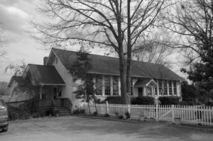
The American Legion was quick to make an offer on the Caldwell Station School building and property.  A price of $600 was agreed upon in March of 1932, and the site was sold to American Legion Post #86 in April. (17)  The American Legion expanded the building with a full-width rear shed addition which greatly enlarged the formerly shallow building.  This allowed the Post to hold square dances in the building. (18) The building was later sold into private hands and was used as a commercial space until it was purchased in 1991 by a preschool.  It is now known as the Children’s Schoolhouse, and is again functioning as an educational facility.


Architectural Context

The autonomy of the local committees and communities is reflected in the diversity of  the designs of the surviving schoolhouses in northern Mecklenburg County.

The side-gabled Caldwell Station Schoolhouse has little in common with the ca. 1920 Mallard Creek School, a four-teacher  frame schoolhouse, which was also built in northern Mecklenburg County.  The massed building is set on brick piers and features a center entrance sheltered by a shed roof. The building’s most distinguishing feature is a steeply pitched hipped roof pierced by two internal chimney at the ridge. Likewise, the nearby small  front-gabled Caldwell Bradford School (now remodeled as a home) shares little architecturally with the Caldwell Station Schoolhouse.

Architecturally the Caldwell Station Schoolhouse has much more in common with the African American  schools of  the 1920s built in Mecklenburg County, than with the county’s other rural white schools. The nearby Caldwell Rosenwald School was built in 1925 to serve the black children who lived along the Catawba River in northern Mecklenburg County.  The Caldwell Rosenwald School and the Caldwell Station School bear a strikingly similar appearance, especially if one considers that the Caldwell Station School’s central entrance was a later addition.  Both are side-gabled buildings that feature on the facade two banks of six tall sash windows that run uninterrupted to the roofline.  Both also feature a shallow gabled wing containing the entrance.  The buildings are not identical.  The Caldwell Rosenwald School is a four-classroom building and is much deeper that the Caldwell Station School, with less steeply pitched gables.

In contrast to the white rural schools in Mecklenburg County, the African American schools built in the county during the 1920s followed  professionally developed plans distributed by the  Julius Rosenwald Foundation throughout the South.  Julius Rosenwald was the President of Sears, Roebuck and Company.  His foundation distributed funding and plans for African-American schools that were cost-effective to build, and resulted in a orderly and well lit learning space.  One of the most recognizable features of the Rosenwald schools was the use of banks of tall sash windows like those found on the Caldwell School. These large banks of windows were especially important as many rural schools lacked electricity.   There were at least twenty-six Rosenwald schools built in Mecklenburg County.  It is not surprising that these practical, well designed plans inspired the building of white schools as well.

Caldwell Station School above.  Caldwell School (Rosenwald) below.

The above is a rendering of the #400 Rosenwald four-teacher school building published by the Rosenwald Foundation illustrates that the Caldwell School closely adhered to the published plans.  Below is the  #400 floor plan.

As built, the Caldwell Station School, in essence, used half of the floor plan for the #400 building (shown below), and replicated the façade.

The Caldwell Station School is a one-story, side-gabled  frame building, set on a continuous brick foundation.  The principal section of the building is one room deep. The building faces west, is located on a one acre lot, and is set back approximately 100 feet from a one lane paved Caldwell Station Road.  The road runs near a north-south rail line, the former Atlantic, Tennessee, and Ohio.  The small road is separated from the rail bed by approximately 150 feet.  To the west of the rail line runs NC Hwy 115, a busy two lane highway that connects Huntersville and Cornelius.  The area around the schoolhouse contains elements of typical of the school’s historic rural setting.  To the north and south of the school within a few hundred feet of the building are large open field.  Along Caldwell Station Road are several early 20th century houses.  There has also been significant late 20th century development around the schoolhouse, including a mobile home park to the south, and an industrial warehouse to the west across the highway.

View of Caldwell Station Road looking south

The fenestration of the facade of the Caldwell Station School is limited to three openings, a single doorway and two large window openings.

The Caldwell Station School features a doorway centered on the facade, bordered on each side by large banks of windows.  The doorway contains a Craftsman Style three-light two-panel door sheltered by a small gabled roof.  The doorway is not original, but may have been added during the 1930s.  The porch’s gabled roof is supported by two 4×4″ posts and features a plywood deck.  The porch roof and frame may be of recent construction.  A wooden porch floor and wooden steps cover an earlier brick stoop.

The most dominant architectural features of the Caldwell Station School are two banks of tall nine-over-nine double-hung windows.  Each bank of windows contains six windows that share a single wooden sill.  The windows rise to the top of the wall, with the roof’s exposed rafter tails extending slightly below the top rails of the upper sashes.


The building is covered with German siding, and features exposed rafter ends.  The continuous brick foundation runs uninterrupted without indication of piers.  The crawlspace is ventilated by cross-shaped openings left in the brickwork. The roof pitch is moderately steep and the roof is covered by asphalt shingles.

The north elevation features a shallow gabled wing with a recessed porch.  This porch sheltered one of the two original side entrances to the building.  The porch roof is supported by a single 4×6″ post.  German siding boxes the beams supporting the porch roof on the exterior and bottom of the beam, and beaded board is used on the interior side of the beam.  The porch ceiling is also covered with beaded board.   The porch walls are the same German siding found on the rest of the exterior.  An older six panel door appears to have replaced an older door.  The north elevation of the principal section features a louvered vent set high in the gable, and is otherwise blank.  Both original gables on the north elevation feature deep eaves supported by simple timber brackets.  The roof deck is visible in the eaves and is composed of tongue-and-groove boards.


Several additions have been made to the Caldwell Station School.  None of them exhibit the same high level of finish and workmanship found on the original section of the building.  A low-pitched gabled wing was added to the north elevation and now obscured some of the original gabled wing.  The later wing contains paired double-hung six-over-six windows, and is covered with German siding.   An odd gable extension was built above a portion of the original wing to bridge a valley between the wings.  The extension is sheathed with vertical boards and has no overhanging eave.


The rear elevation features a large full-width shed addition.  The design of the continuous brick foundation continues from the original principal section of the building.  The shed addition is covered with German siding and is pierced on the rear by six wide window openings, filled with replacement windows.  The roof overhang is minimal.  Eaves on the sides of the addition reveal simple board decking and small wooden brackets, much smaller than those found on the principal section.  A large crawlspace door  is located on the rear foundation wall.


The south elevation clearly demonstrates the lower roof pitch of the rear shed addition.  The addition joins the principal section at the location of a simple brick flue.  A door pierces the south elevation of the rear addition.  The gable of the south elevation of the principal section of the building contains a louvered vent.  Much of the remainder of the north elevation is obscured by a recent gabled wing, with a new textured brick foundation.  This wing appears to be completely new construction.  However, it is in the location of an original wing that would have contained a recessed porch and an additional entrance.

While significant additions have been made to the exterior, most of the additions were done early in the 20th century and contribute to the understanding of the building.  The building’s integrity, condition and setting all contribute to the significance of the property.

The interior of the Caldwell Station School has experienced considerable alteration, but important elements of the historic interior architecture have survived.  The 1925 building was expanded sometime in the 1930s when it became an American Legion post.  A large section of the original rear wall of the building was removed when a full-width shed addition was added to the building.  The high ceilings and open space of the original section has been maintained.  The shed addition is also largely open, but features a lower ceiling.  The spaces are connected through a large opening in what was the original back wall of the school.

The floors of the school are entirely tongue-and-groove pine board.  When the rear addition was added, a similar pine flooring was used.  It is likely that the entire interior of the original section was originally paneled with tongue-and-groove pine boards.  Wallboard now covers the woodwork of the ceiling and much of the walls, but it is likely that much of the original wall material survives behind wallboard.  Below the level of the window sills the original beaded boards are exposed as wainscoting.  Simple wood trim surround the windows and the original doorway on the north end of the building, as well as the door set in the center of the front wall.  The other doorways appear to be recent openings.

Despite the alterations to the interior, the much of the historic character of the interior remains.  The exposed original floors and the open classroom spaces help the visitor under stand the historic use of the building.  While covered by wallboard, the retention of the original wall paneling could allow for further restoration of the interior space.

NOTES

  1. Post Offices in the United States, Arranged in Alphabetical Order, (Washington: J&GS Gideon Printers,) 1842
  2. Chalmers Davidson describes Hickory Grove and Glenwood in his book The Plantation World Around Davidson (Davidson: Davidson Printing Company, 1969
  3. 3. “North Carolina Railroads – Passenger and Freight Lines”  Website:

http://www.carolana.com/NC/Transportation/railroads/nc_railroads.htm

  1. “Postal History” Website: http://www.postalhistory.com/index.htm
  2. “Gray’s new map of North Carolina and South Carolina,” (Philidelphia:O. W. Gray & Son, 1881)  Available at the Carolina Room of the PLCMC.
  3. LeGette Blythe and Charles R. Brockmann, Hornet’s Nest, (Charlotte: McNally, 1961) p. 419.
  4. Sarah A. Woodard and Sherry Joines Wyatt, “Industry, Transportation, and Education:The New South Development of Charlotte and Mecklenburg County,” 2001.  Part of a National Register Survey prepared for the Charlotte-Mecklenburg Historic Landmarks Commission.
  5. “Mecklenburg County Board of Education, The Minute Book 1885-1960”  Unpublished minutes in the J. Murrey Atkins Library Special Collections, University of North Carolina-Charlotte.
  6. Sarah A. Woodard and Sherry Joines Wyatt, “Industry, Transportation, and Education:The New South Development of Charlotte and Mecklenburg County,” 2001.  Part of a National Register Survey prepared for the Charlotte-Mecklenburg Historic Landmarks Commission.
  7. “Mecklenburg County Board of Education, The Minute Book 1885-1960”  Unpublished minutes in the J. Murrey Atkins Library Special Collections, University of North Carolina-Charlotte.
  8. Interview with Wilson Knox, October 2009, by the author.  Wilson Knox was born in 1919, and attended the Caldwell Station School in 1929.
  9. Emily D. Ramsey, “Survey and Research Report of the Mallard Creek School,” 2000.  Prepared for the Charlotte-Mecklenburg Historic Landmarks Commission.
  10. “Mecklenburg County Board of Education, The Minute Book 1885-1960”  Unpublished minutes in the J. Murrey Atkins Library Special Collections, University of North Carolina-Charlotte.
  11. Interview with Nell Washam Caldwell, September 2009, by the author.
  12. “Mecklenburg County Board of Education, The Minute Book 1885-1960”  Unpublished minutes in the J. Murrey Atkins Library Special Collections, University of North Carolina-Charlotte.
  13. Ibid
  14. Ibid
  15. Interview with Wilson Knox.


Bryant Park

1. Name and location of the property: The property known a Bryant Park is located at 1701 West Morehead Street in Charlotte, NC. (UTM: 17 511932E 3898077N)
2. Name and address of the current owner of the property:
The current owner of the property is:

Mecklenburg County

600 East 4th Street

Charlotte, NC

3. Representative photographs of the property: This report contains representative photographs of the property.

4. A map depicting the location of the property: This report contains a map depicting the location of the property.

5. Current deed book reference to the property: The most recent deed to the property is found in Mecklenburg County Deed Book 1044, page 216. The tax parcel number for the property is 67-014-01.

6. A brief historical sketch of the property: This report contains a brief historical sketch of the property prepared by Emily D. Ramsey.

7. A brief physical description of the property: This report contains a brief physical description of the property prepared by Emily D. Ramsey.

8. Documentation of why and in what ways the property meets the criteria for designation set forth in N.C.G.S. 160A-400.5.

a. Special significance in terms of its history, architecture, and/or cultural importance. The Charlotte-Mecklenburg Historic Landmarks Commission judges that Bryant Park possesses special significance in terms of Charlotte-Mecklenburg. The Commission bases its judgment on the following considerations:1. Bryant Park, constructed in the mid-1930s to serve residents in the neighborhood of Wesley Heights, was one of the first small scale public parks in Charlotte, and represents the early stages of the twentieth century push for neighborhood public green space.2. Bryant Park’s complex network of granite stone walls and distinctive stone seating above the softball field was completed during the height of the Great Depression, most likely as part of the Works Progress Administration (the W.P.A.), and remains as possibly a tangible reflection of the local impact of New Deal work programs.

3. Located in an increasingly dense area of urban development (now escalating after the completion of nearby Ericsson Stadium), Bryant Park is the only public park and green space remaining in Charlotte’s West Morehead Street industrial sector.

b. Integrity of design, workmanship, materials, feeling, and association.

The Commission contends that the architectural description by Emily D.

Ramsey demonstrates that Bryant Park meets this criterion.9. Ad Valorem Tax Appraisal: The Ad Valorem Tax value of the 6.6 acres of land and all improvements on the property is $395,310. The property is zoned I-2.

Date of Preparation of this Report:

August 1, 2001

Prepared By:

Emily D. Ramsey

745 Georgia Trail

Lincolnton, NC 28092

Statement of Significance

Bryant Park

1701 West Morehead Street

Charlotte, NC

Summary

Bryant Park, begun in 1930 and completed during the height of the Great Depression, is a property that possesses local historic significance as one of Charlotte’s first small-scale public parks, and  as a tangible reminder of the early stages of the twentieth century push for public green space within the city. Although Latta Park, Charlotte’s first public park, was completed with much fanfare in the early 1890s, the concept of public recreational and natural green spaces gained acceptance slowly among city officials. Despite the creation of the Charlotte Park and Tree Commission in 1904, in the years between the turn of the century and the end of World War II the city’s parks system continued to rely on the staunch support of Charlotte-Mecklenburg’s private sector, rather than the support and funding of local government. Established on land donated by prominent developer E. C. Griffith, Bryant Park was one of the first projects of the Charlotte Park and Recreation Commission, which replaced the Charlotte Park and Tree Commission in 1927. Independence Park, Latta Park and Revolution Park, established in the years before the Great Depression, were large, sprawling expanses of carefully landscaped natural areas (Revolution Park encompassed over 240 acres), funded in large part by private funds and located outside of the center city area to service newly developed garden suburbs. The creation of Bryant Park in the early years of the Charlotte Park and Recreation Commission heralded a new kind of green space, the small neighborhood park, which would become extremely popular in the boom period after World War II. Although small and minimally landscaped, these parks would provide recreation space for the majority of Charlotte’s residents throughout the twentieth century.


Bryant Park is also significant as the earliest public park established within one of Charlotte’s most prolific industrial sectors, stretching along West Morehead Street. Serviced by a line of the Southern Railroad (which connected Charlotte to the nearby textile center of Gastonia) and connected to center city Charlotte by a newly constructed streetcar line, the area west of Charlotte’s central business district quickly developed into a thriving industrial district. Developers erected rows of working class houses in the Wilmore and Wesley Heights neighborhoods, and working class families flocked to west Charlotte in the early decades of the twentieth century. Bryant Park, located between Wesley Heights and Wilmore, provided west Charlotte residents with green space for a welcome respite from the noise of the factories and with specialized spaces (including a softball field, tennis courts, a volleyball court, and horseshoe pits) for a variety of recreational activities. Although the park has since lost many of these recreational amenities, Bryant Park, with its terraced hillside leading down to a wide expanse of green playing fields, and with its intricate and distinctive stonework, remains an important reminder of the evolution of green space within Charlotte’s urban landscape.
Bryant Park’s development began in 1929-1930, but was stymied by the onset of the Great Depression, when public monies became scarce. The park’s construction, which primarily involved the construction of a complex configuration of stone boundary walls, terrace walls and stone seating for the large softball field, was completed during the height of the Great Depression, most likely with funding and labor provided by the Work’s Progress Administration, a federal government agency created by New Deal legislation to give local men and women needed jobs. Although the impact of New Deal work programs in Charlotte were most visible in the few large-scale projects like Memorial Stadium, Bryant Park reflects the influence of Federal programs on the neighborhood level.

Historical Background and Context Statement

The concept of public green space, although fully developed among academic circles and within northern cities by the end of the nineteenth century, did not gain widespread acceptance in New South cities like Charlotte until well into the twentieth century. In the mid-nineteenth century, cemeteries often served double duty as recreational green space, where residents and visitors could go to escape the noise and congestion of the city, and Charlotte continued to use their shady, quiet cemeteries as impromptu parks until the turn of the century . Charlotte had experienced unprecedented economic and physical growth in the last decades of the nineteenth century, yet “the amount of green space within the city . . . remained a constant: Settlers’ and Elmwood cemeteries.”1 Not surprisingly, Charlotte-Mecklenburg’s New South leaders, who had transformed Charlotte from a small farming community into a regionally important cotton trading and textile center, were among the first to grasp the importance of green space as an integral part of the city’s built environment. Entrepreneurs such as Edward Dilworth Latta, George Stephens, and Daniel Augustus Tompkins threw their support behind the concept of public green space by creating impressive, meticulously planned early examples of garden suburbs like Myers Park and Dilworth and neighborhood parks like Latta Park and Independence Park..

Initially, Charlotte seemed ready to embrace full-scale, long term city planning and the development and preservation of green spaces. Inspired by the success of Myers Park, the Charlotte Chamber of Commerce hired John Nolen, Myers Park’s designer, to conduct a civic survey and create a comprehensive city plan to control and direct future growth.2 Despite the city’s initial enthusiasm, Nolen’s ambitious plan for Charlotte’s growth, which included room for parks, lush garden suburbs and a scenic byway, was ultimately rejected by the Chamber, a decision which would affect the evolution of Charlotte-Mecklenburg’s green space for the rest of the century. Without financial support from the city and local government, green space developed only where sufficient private funds existed to pay for it. Not surprisingly, the first park established within the Charlotte area was created by businessman and developer Edward Dilworth Latta. Latta Park, completed in 1890, encompassed over seventy acres in the middle of the newly developed Dilworth neighborhood, but, with its large recreational lake and scenic walkways, it attracted people from all over Charlotte, and created interest in the possibility of green spaces within Charlotte’s center city communities.

Although interest in and demand for public parks grew significantly in the late nineteenth and early twentieth century, Charlotte’s government remained too small and unorganized to take on the responsibility of public green spaces. As historian Brian Sturm writes, Charlotte’s Board of Aldermen “refused to make parks a city priority because of the assumption that recreation was not the business of city government.”3 Once again, private interests came through to support the development of a formal government body devoted to establishing public parks and green spaces. D. A. Tompkins exerted his significant influence with the city, and lobbied tirelessly in favor of public parks in general and, specifically, the development of Independence Park, Charlotte’s first municipal park. Public parks, Tompkins argued, would bring upper and working classes together and were an important part of a productive work environment. “There are working people in our factories,” he told the Board, “who scarcely ever see the green grass, flowing water, and waving trees of the country. The park will afford them these with the few aides of nature we can put out there.”4 Tompkins succeeded, despite the apathetic nature of the board – in 1904, the Charlotte Park and Tree Commission was established, with Independence Park as the commission’s first project.5 After Independence Park’s completion, however, the activity of the Charlotte Park and Tree Commission practically ceased, due to lack of funding. Even with Tompkins serving as chair, the commission failed to create significant green spaces during the early decades of the twentieth century, despite the fact that Charlotte’s economy was booming and public buildings were being constructed at an unprecedented rate.6


In the late 1920s, E. C. Griffith, a prominent local developer and large center city landowner, donated 16 acres of land between the Wilmore and Wesley Heights neighborhoods in the rapidly developing industrial sector of west Charlotte to the Charlotte Park and Recreation Commission.7 The plot of land, named Bryant Park, was slated for development as a small neighborhood recreational center. Work began tentatively in 1930, but the onset of the Great Depression and subsequent shrinking budget forced the Charlotte Park and Recreation Commission to stop work on most of its projects, including Bryant Park.8
The push for public green space entered its second stage in the year 1927, when the Charlotte Park and Tree Commission became the Charlotte Park and Recreation Commission. Although the new commission received funds through a small city tax, it remained financially unable to build new parks without the help of private funds. However, with several parcels of land, ranging from over 200 acres to less than ten acres, donated by wealthy local entrepreneurs, the commission began, slowly but surely, establishing parks in Charlotte. Most of these new parks, in contrast to Latta Park, Independence Park, and the recently completed Revolution Park, were mainly small parcels of land developed to serve specific neighborhoods. Bryant Park was among the first of these small neighborhood parks.

Despite the initial complications caused by the severe economic downturn of the late 1920s and early 1930s, the New Deal programs of the Roosevelt administration that came out of the Great Depression proved to be “a boon to parks and recreation” programs across the country. The Charlotte Park and Recreation Commission received Federal funds for a variety of projects, with most of the money and labor coming from the Works Progress Administration (later renamed the Works Projects Administration) and the Civilian Conservation Corps. Although only the biggest of Charlotte’s Federal parks projects, including Memorial Stadium and the city’s first municipal swimming pool, received widespread attention, a variety of small park projects that had been stalled by the economic slowdown were completed with the help of 1930s New Deal work programs. Bryant Park was most likely one of the small park projects to benefit from these Federal programs. The elaborate stonework seen throughout Bryant Park, which created seating for the park’s softball field and circled the perimeter of the park as a network of low walls, is nearly identical to the stonework used in W.P.A. projects across North Carolina, including the stonework in nearby Independence Park, which was completed in part through Federal funding during the 1930s.9 Moreover, the park was completed by the early 1940s, before the 1949 bond initiative that promised to create “a playground within a half-mile of every home” in Charlotte-Mecklenburg, and well before the 1950s boom period for parkland acquisition.10 As one of the earliest small public parks completed in Charlotte, Bryant Park was a model for the dozens of neighborhood parks constructed in the post-war period, and, with its softball field, volleyball and tennis courts, and horseshoe pits, it served as a recreational center for the surrounding Wesley Heights and nearby Wilmore  neighborhoods. However, as the Charlotte Mecklenburg Park and Recreation Commission suffered from ongoing lack of funding in the 1960s and 1970s, and as more and more industrial development crowded along the main artery of West Morehead Street in the last half of the twentieth century, Bryant Park lost many of its original recreational spaces. The park today has retained only 6.6 of its original 16 acres, and the only designated recreational space that remains is the centerpiece of Bryant Park, the softball field.


Bryant Park, set among the dense clustering of low brick industrial buildings that line West Morehead Street, is also locally significant as the earliest public park established within one of Charlotte’s most prolific industrial sectors, stretching along West Morehead Street. Serviced by a line of the Southern Railroad (which connected Charlotte to the nearby textile center of Gastonia) and connected to center city Charlotte by a newly constructed streetcar line, the area west of Charlotte’s central business district quickly developed into a thriving industrial district. Prominent businesses such as the Grinnell Company and the Coca-Cola Company built their plants along West Morehead Street Developers such as F. C. Abbott erected rows of working class houses in the Wilmore and Wesley Heights neighborhoods, and working class families flocked to west Charlotte to work and live in the early decades of the twentieth century.11 The construction of Bryant Park in the 1930s reflected the increasing importance of these west Charlotte working class neighborhoods and the industrial economy they supported.
Physical Description and Site Context

Bryant Park comprises 6.6 acres of terraced hillside and flat playing field, bound on the north by West Morehead Street, on the west by Suttle Avenue, and on the east by a small creek bed. The main entrance to the park is located on the south end of the property, on the park’s highest elevation, and leads to the most impressive feature of the park – the stone seating for the park’s only remaining recreational space, the softball field. A complex network of steps, walls of varying heights, and wide benches are arranged organically into the steeply sloping hillside, and, from a distance, seem almost to be a natural outcropping. The stone bleachers, like the retaining walls along the terraced hill south of the softball field and the low walls and entrance that line the north side of the park, along West Morehead Street, are made of a thick layer of common stone and rubble faced with more finished granite stones. A shady, steeply sloped area to the west of the softball field is dotted with benches and mature trees. The hilly area and the softball field on the southern end of the park give way to a broad, uninterrupted expanse of green lawn, which stretches north to West Morehead Street. As the only green space located within the industrial sector of west Charlotte, which once provided the residents Wilmore and Wesley Heights with a welcome respite from the noise of the factories and with specialized spaces (including a softball field, tennis courts, a volleyball court, and horseshoe pits) for a variety of recreational activities, and as one of the earliest public parks completed in Charlotte, Bryant Park remains an integral part of the city’s built environment and a visual reminder of the evolution of green space within Charlotte’s urban landscape.

_________________________________

1.  Brian W. C. Sturm, “The Evolution of Green Space: A History of Urban Landscape in Charlotte, North Carolina, 1890-1990” (honors thesis, University of North Carolina at Chapel Hill, 2000), 1-2.

2.  Thomas W. Hanchett, “Charlotte’s Neighborhood Planning Tradition,” (Charlotte-Mecklenburg Historic Landmarks Commission, 1986), 3.

3.  Sturm, 21.

4.  The Charlotte Observer, August 2, 1904.

5.  The Charlotte Observer, November 8, 1904 and Jun 6, 1905.

6.  Ibid.

7.  Legette Blythe and Charles R. Brockmann, Hornet’s Nest: The Story of Charlotte and Mecklenburg County (Charlotte, 1961).

8.  The Charlotte Observer, February 28, 1950.

9.  J. S. Curt, W. A. Cutter, and Thomas Morse, Emergency Relief in North Carolina: A Record of the Development and Activities of the North Carolina Emergency Relief Administration (Raleigh, 1936).

10.  Sturm.  Clippings from file labeled “Parks and Recreation,” located in the Vertical files of the Robinson Spangler North Carolina Room of the Charlotte Mecklenburg Public Library.

11.  Dr. Dan L. Morrill, “Survey and Research Report on the Electric Supply and Equipment Company” (Charlotte Mecklenburg Historic Landmarks Commission).


Walter Brem House

This report was written on July 12, 1983

1. Name and location of the property: The property known as the Walter Brem House is located at 211 East Boulevard, in Charlotte, North Carolina.

2. Name, address and telephone number of the present owner of the property: The present owner of the property is:

Mr. Henry Blume
3601 Kelway Avenue
Charlotte, N.C. 28210

Telephone: 552-6391

3. Representative photographs of the property: This report contains representative photographs of the property.

4. A map depicting the location of the property: This report contains a map which depicts the location of the property.


5. Current Deed Book Reference to the property: The records of the Mecklenburg Tax Office do not contain a current deed book reference to the property. The Tax Parcel Number of the property is: 123-0742.

6. A brief historical sketch of the property: This report contains a brief historical sketch of the property prepared by Dr. William H. Huffman.

7. A brief architectural description of the property: This report contains an architectural description of the property prepared by Lisa A. Stamper.

8. Documentation of why and in what ways the property meets the criteria set forth in N.C.G.S. 160A-399.4:


a. Special significance in terms of its history, architecture, and/or cultural importance: The Commission judges that the property known as the Walter Brem House does possess special significance in terms of Charlotte-Mecklenburg. The Commission bases its judgment on the following considerations: 1) the Walter Brem House, erected in 1902-03, was designed by C. C. Hook, Charlotte’s first permanent resident architect and an architect of local and regional significance; 2) the original owner, Walter Brem, was married to the daughter of Governor Todd Robinson Caldwell, was an early business associate of George Stephens, develop of Piedmont Park and Myers Park, and was an important civic leader in Charlotte until his death in 1925; 3) Mr. R. D. Craver, a subsequent owner, was a pioneer in the motion picture business in the two Carolinas; 4) the Walter Brem House is one of the earliest and grandest examples of the Colonial Revival style in Charlotte; 5) the Walter Brem House is one of the oldest houses on East Boulevard and occupies a strategic townscape position in Dilworth, Charlotte’s first streetcar suburb.

b. Integrity of design, setting, workmanship, materials, feeling and/or association: The Commission contends that the attached architectural description by Miss Lisa A. Stamper demonstrates that the Walter Brem House meets this criterion.

9. Ad Valorem Tax Appraisal: The Commission is aware that designation would allow the owner to apply for an automatic deferral of 50% of the Ad Valorem taxes on all or any portion of the property which becomes “‘historic property.” The current appraised value of the .321 acres of land is $42,000. The current appraised value of the improvements is $55,420. The total current appraised value is $97,420. The property is zoned B1.

Date of Preparation of this Report: July 12, 1983

Prepared by: Dr. Dan L. Morrill, Director
Charlotte-Mecklenburg Historic Properties Commission
218 N. Tryon Street
Charlotte, North Carolina 28202

Telephone: 704/376-9115


Historical Overview
 

Dr. William H. Huffman
August, 1981

In July, 1902, the Charlotte Consolidated Construction Company, otherwise known as the Four C’s, began building one of the early houses on Boulevard East in the new streetcar suburb of Dilworth for Walter and Hannie Caldwell Brem. 1 The Four C’s was organized in 1890 by Edward Dilworth Latta to develop 250 acres of rural land south of the city, the accomplishment of which was facilitated by the opening of Charlotte’s first trolley line from the Square to Latta Park in 1891. The Brems had engaged C. C. Hook, Charlotte’s first resident architect, to design the house. 2 Charles Christian Hook (1870-1938) had settled in Charlotte in 1891 to teach in the Charlotte Graded School at South Boulevard and E. Morehead Streets. His arrival in the same year as the beginning of the Four C’s development of Dilworth resulted in many early commissions for dwellings in that community. Some of the best known structures designed by Hook were the Charlotte City Hall and the James B. Duke mansion. 3

Sketch of the Walter Brem house

from “Some Designs,” a promotional booklet published by Hook & Sawyer Architects ca. 1902

Walter Brem was born in Charlotte July 31, 1849, and was one of the few citizens of the city whose parents were also born in town. He was the son of Col. Thomas H. Brem, commander of Brem’s Battery in the Civil War, and Martha Fox Brem, who descended from the prominent Erwin family of Burke County. Walter Brem, in association with William H. Martin, was at one time the owner of a hardware store at the southeast corner of Trade and Tryon Streets, and, about 1890, went into the insurance business with George S. Stephens, who was a college friend of his son’s from Chapel Hill. In 1902, Mr. Stephens married Sophie Myers, daughter of John Springs Myers, and subsequently developed his father-in-law’s 1200-acre farm into the Myers Park subdivision. Mr. Brem spent the remainder of his business career as head of Walter Brem and Sons, general agents for the Traveler’s Insurance Co. During his life he was actively involved in the Charlotte public school system and the city YMCA. He died at the age of 76 on February 11, 1925. 4

Hannah Caldwell Brem, who was born in Morganton on November 4, 1851 and died in Charlotte April 21, 1931, was the daughter of Governor Todd Robinson Caldwell of Morganton. 5 The Brems had four children: Dr. Walter Brem (a fraternity brother of, and semi-pro ballplayer with George S. Stephens), who practiced medicine in Los Angeles; Todd Robin Brem, Mina Brem (Mrs. Robert A.) Mayer, and Helen Brem (Mrs. R. R.) Beatty, all of Charlotte. In 1903, when they moved into the fine house on Boulevard East (for which they paid $6045.86), the latter three children were still at home, but Mina Brem was married later that same year and no longer lived at the residence. 6 In 1912, the Brems bought a smaller, Queen Anne style house a block to the east of the one they had built, which was constructed eight months after theirs. 7 Their original house was rented briefly and stood vacant for some months before it was sold to Regger D. Craver in 1914 for the consideration of $9000.00. 8

Mr. Craver was a pioneer in the motion picture business in the Carolinas. At one time, he was one of the largest individual theater owners in the South, which included movie houses in the Carolinas and Virginia. In Charlotte, he operated the old Broadway theaters on East Trade and West Trade Streets, and afterward operated the Broadway theater on South Tryon. The Cravers lived on East Boulevard with their four sons, Gilda, R. D., Jr., William and Alton. In 1928, Mr. Craver was stricken and died after a brief illness at the age of 50. He was survived by the children and his wife, the former Bessie Jenkins of Gastonia. 9 Mrs. Craver continued to live in the house after he husband’s death, but apparently could not maintain it when the Great Depression hit with full force, for in 1931, it was sold at a foreclosure sale to the South Atlantic Investment Corp. for $8470.64. 10

Once more the house stood vacant as it changed owners among investors twice in 1932, then went back to the ownership of the South Atlantic Investment Corp. in 1934. 11 In the latter year, the house was rented to Thomas K. Culp, a foreman for the Southern Power and Utility Company, who remained until it was purchased in 1936 by Mrs. Mae King Blume. 12 Mrs. Blume, the widow of John H. Blume, converted the property to the Colonial Apartments, a name which was maintained for many years. 13 In 1936, Mrs. Blume was the proprietor of the Piedmont Hotel, Queen City Hotel, Frances Hotel, Windsor Hotel, Southern Hotel, the Franklin Hotel and the manager of the New Albert Hotel. 14 Mrs. Blume moved to 211 E. Boulevard in 1939, and has lived there to this date. 15


NOTES

1 Charlotte Observer, July 15, 1902, p. 6.

2 Some Designs by Hook and Sawyer, Architects, Charlotte, N.C. (Charlotte: Queen City Printing, 1902, p. 38.

3 “Survey and Research Report on the Seaboard Air Line Railroad Passenger Terminal,” Charlotte Mecklenburg Historic Properties Commission, undated.

4 Charlotte Observer, Feb. 12, 1925, p. 4; Interview with Dr. Walter Brem Mayer, 28 July 1981.

5 Certificate of Death, Book 48, p. 615; Charlotte Observer, Feb. 12, 1925, p. 4.

6 See note 4; Deed Book 173, p. 497, 20 Feb. 1903.

7 The house was built for William G. Crutchfield, who purchased it from the 4 C’s on 13 Oct. 1903. (Deed Bk. 182, p.8) See “Historical Sketch of the Crutchfield House,” by Dr. William H. Huffman, Charlotte-Mecklenburg. Hist. Prop Comm., August, 1981.

8 Charlotte City Directory, 1913, p. 530; 1914, p. 591; Deed Book 327, p. 574, 7 Sept. 1914.

9 Charlotte Observer, Dec. 20, 1928, p. 6.

10 Deed Book 809, p. 487, 14 Nov. 1931.

11 Deed Book 814, p. 593, 28 April 1932; Deed Book 827, p. 49, 25 Oct. 1932; Deed Book 849, p. 266, 20 Feb. 1934.

12 Deed Book 900, p. 467, 9 May 1936.

13 Charlotte City Directory, 1937, p. 776 and subsequent years.

14 Ibid., 1936, p. 105.

15 Ibid., 1939, p. 747.


Architectural Description
 

by Lisa Stamper

Located near the corner of East and South Boulevards, the Walter Brem house still exhibits the grandeur of the fine Colonial Revival homes of the turn of the century. One of Charlotte’s first examples of the style, this magnificent two-story residence was designed by C. C. Hook, a prominent Charlotte architect. When erected in c. 1902-1903, East Boulevard was a fashionable residential street which was the showplace of Dilworth, the city’s first streetcar suburb. The Brem House has been added to over the years, and the original wooden clapboard siding has been covered with white asbestos siding. However, much of its fine detailing remains intact.

Originally, the Brem House was basically a rectangular house with two squarish, small ‘pavilions’ on both front corners. Between the projecting pavilions was a large one-story balconied entry portico. It also had a balconied one-story back porch. Over the years, numerous additions have been made to the back of the house. Also, an addition has been made to each side of the building.

The main portion of the house has a decorative slate tile roof, with a low pitch. It also has two small, symmetrically placed dormers at the front. the dormers are heavily pedimented and have diamond shaped glass panes. The two pavilions have flat roofs with broad bracketed eaves. Originally a wooden balustrade topped these roofs. These balustrades had heavy, paneled corner posts.

The Brem House has four original brick chimneys. Two identical exterior side chimneys bisect the sides of the pavilions. Another chimney is an interior one which is located in the back and off to one side. It was an interior chimney to avoid interference with the back porch design. the first two chimneys mentioned are thin, arcaded stacks with slightly stepped shoulders. The tops of these stacks have five courses of corbelling. These two chimneys have been painted brick red from the ground to the eaves, but have not been painted above the eaves. The interior chimney within the hipped roof is thicker and more square than the side chimneys. However, the five-course corbelled top is the same style. The back chimney is very simple. It is just a thin, rectangular stack without embellishment. New brick can be seen at the top of this chimney; therefore, possibly the top of this chimney once had corbelling like the others.

The composition of the impressive front facade was symmetrical and very well planned. Decorative corner boards on the second level of the wings lightened the second story as well as defined it. The first level was separated from the second level by horizontal wooden coursing. Repetition of the pedimented dormers was created by the pediment window heads of the second-level windows of the wings. On the second level, two more single-paned, double-hung windows were placed below the dormers. The first level of the front facade had for single-paned windows, topped with stained glass rectangular panels. Straight wooden window heads and frames unified the two types of glass. One windows was located in each wing, while the other two flanked the double door. The door was horizontally paneled with glass in its upper portion. Wooden pilasters flanked the door.

The front portico was magnificent. Six symmetrically placed columns held up the portico. These columns, along with the plain entablature, were of the Tuscan Order. Large projecting brackets support the projecting cornice. Its balustrade had six thick, paneled posts that corresponded to the columns below. However, these posts were thinner than those on the pavilions’ balustrades. These posts were topped with urns. Steps lead from the columns up to the porch deck, which extended from pavilion to pavilion. A railing identical in style to the pavilions’ balustrades enclosed the high porch.

Today, the corner boards are gone. One pediment window head is missing. A door has been placed between the two second story windows in the central section to allow access to the top of the portico. An awning covers the doors and windows. The portico’s wooden balustrade has been replaced with a simple, cast iron one. The other balustrades are gone. A side section of one porch was removed and a set of metal stairs was added. However, only one bracket is missing, the rest of the railing is intact, the columns are in excellent condition, the dormers seem unaltered, and the slate tile is still intact.

The sides of the house were identical before the additions were made. It is difficult to discern exactly how many windows were on each side, but it appears to have been six, four on each wing and two on the main portion, near the back. Both the first- and second-story windows were single-paned, double-hung sash. Probably all the windows of the Brem House, and definitely the ones on the sides and front, had dark, louvered shutters. None of these shutters remain on the house today.

The back facade is covered with a hodgepodge of additions, so it is difficult to determine what was once there. To visually balance the asymmetrically placed back chimney, a pediment was located on the back. From an early photograph, a corner of the back porch can be seen. The back porch was not as impressive as the front, but it also had a balustrade complete with urns, wide eaves, Tuscan Order columns, and a surrounding wooden rail. The columns, railing, etc., were removed when the back porch was converted into part of an apartment.

The additions are used as apartments, as is the original house. Some of the additions are two-story and some are one-story. Stairs run wild on the exterior of these additions. The additions have brick foundations, as does the original house. For uniformity, all the brick was painted, and white asbestos siding with wood grain texture was placed on all the additions and the original house.

Inside the Walter Brem House, the original floor plan seems to have been symmetrical, as befitting a Colonial revival style house. Many walls were later added to create apartments, especially on the second level, and original walls are often hard to identify. The first level rooms all have high ceilings, while the second level rooms all have standard height ceilings. All of the original flooring was probably of wood. Much of the original wall molding is intact. The first level original rooms still have their simple, horizontal wooden wainscoting along most of their walls.

The front entry door opens into a small foyer. Another wooden double door with eighteen glass panes (three panes by six panes) in each side opens into what was once the great hall and is currently used as a lobby. Except for a small additional wall at the left back corner, the great hall is practically unaltered. Much of the early paneled wainscoting and wooden chair rails are still intact. A chandelier was recently removed from the middle of the great hall.

The grand stair begins slightly to the left of the foyer, turns to continue up the back wall of the great hall, and turns once more to connect with the second level. Its wooden balustrade, with thick paneled posts resembling those of the exterior balustrades’ posts, is still intact. Also, the same type of wainscoting found on the great hall walls is found on the walls of the grand stair. Large round pendants hang from underneath the stair posts at the ceiling.

A brick mantel is located in front of the stair facing the front door, offset slightly to the right. Brick brackets support a wide wooden shelf. The fireplace is not currently used.

It appears that four doors lead from the sides of the great hall to the remainder of the home. One single eighteen glass-paned door leads to each pavilion room. The other doors lead to the back rooms of the home.

The mantle in the pavilion room to the right is very ornate. The mantle is mainly of wood, with a brick interior and an intricately-detailed solid metal screen. The mantel has flanking wooden stylized Ionic columns plus large brackets supporting the shelf. Egg and dart molding plus fine dentil molding is used freely in the design, as are garland and festoon ornamentation. It may be assumed that the other pavilion’s mantle is also very elaborate and similar in design. Neither of the pavilion fireplaces are currently in use.

The mantle at the back of the house is of very decorative brickwork. In the middle of the upper portion of the mantle a diamond shaped pattern is created with bricks. The upper portion is separated from the lower portion by massive corbelling. Vertical corbelling is also employed as a decorative feature. This is the only fireplace in the house still in use, according to Mr. Trull, resident of approximately 23 years.

East Boulevard runs in front of the Brem House. A driveway runs next to the South Boulevard side of the house and to the rear of the property. The back of the site is used as a small parking lot for residents. The front yard is well kept and landscaped. Boxwood foundation plantings dominate the yard.

Although a good bit of the interior and exterior decoration is missing from the Brem House, enough is still present to justify historic designation. Also, with the aid of an early photograph, copies of which are in the possession of the Charlotte-Mecklenburg Historic Properties Commission, a very accurate restoration could be made.

This grand home sits on the outskirts of Dilworth, in an area which is fighting to keep its historic character despite the insensitive commercial construction which is replacing many of its interesting earlier buildings. However, this area still has many of those turn of the century grand homes which have been beautifully restored and currently house a variety of businesses. The Brem House is currently for sale, and historic designation could save this home from losing all of its historic significance while encouraging buyers who would positively use the house as an asset to the community.


Bradford Farm and Store

Name and location of the property:  The property known as the Bradford Farm and Store is located at 15908 Davidson Concord Road in Huntersville, North Carolina.


Name, address, and telephone number of the current owner of the property:


The current owners of the property are:


House:

Elizabeth Bradford Milsaps

15908 Davidson-Concord Road

Huntersville, NC 28078

Telephone: (704) 875-2587


Store:

Mary Stewart Bost

P.O. Box 1245

Davidson, NC


Representative photographs of the property: This report contains representative photographs of the property.


A map depicting the location of the property:  This report contains a map depicting the location of the property.

Current deed reference of the property:  The most recent deed to the property found under Tax Parcel Number 007-47-107 is found in Mecklenburg County Deed Book 4887, page 809.  The most recent deed to the property found under Tax Parcel Number 011-09-204 is found in Mecklenburg County Deed Book 5803, page 285.

A brief historical sketch of the property:  This report contains a brief historical sketch of the property prepared by Emily and Lara Ramsey.

A brief architectural description of the property:  This report contains a brief architectural description of the property prepared by Emily and Lara Ramsey.

Documentation of why and in what ways the property meets the criteria for designation set forth in N. C. G. S. 160A-400.5:

Special significance in terms of its history, architecture, and/or cultural importance:  The Charlotte-Mecklenburg Historic Landmarks Commission judges that the property known as the Bradford Farm and Store possesses special significance in terms of Charlotte-Mecklenburg.  The Commission bases its judgment on the following considerations:


1)      The Bradford Farm and Store are tangible reminders of the robust cotton economy that characterized Mecklenburg County in the last half of the nineteenth century.

2)      The Bradford Farm and Store served as an integral part of the Ramah Community – in addition to his store, William Bradford ran a cotton gin, a blacksmith shop, and a sawmill on his property.  William Bradford also served three terms as county commissioner during the 1910s.

3)      The Bradford Farm is a well-preserved example of a sprawling post-Civil War farmstead.  The farmhouse itself is an excellent example of a gable-front-and-wing variation of Mecklenburg County’s most popular rural vernacular form—the I-house.  The farm complex as a whole characterizes the diverse, self-sufficient nature of life in rural Mecklenburg County during the late nineteenth and early twentieth century.

4)      The Bradford Farm contains three unusual examples of early twentieth century concrete construction—the Bradford Store, along with two outbuildings close to the house, all completed in the early to mid-1910s, are rare rural examples of this new building technology in Mecklenburg County.


    1. Integrity of design, setting, workmanship, materials, feeling, and/or association:  The Commission judges that the architectural description included in this report demonstrates that the property known as the Bradford Farm and Store meets this criterion.


  1. Ad Valorem Tax Appraisal:  The Commission is aware that designation allows the owner to apply for an automatic deferral of 50% of the ad valorem taxes on all or any portion of the property which becomes a designated “historic landmark.”  The total current appraised value of the house ($99,600) and associated five acres of land ($72,000) is $171,600.00.  The current appraised value of the store ($4,550) and the associated sixteen and one-half acres ($235,850) is $240,400.


Date of Preparation of this Report:

April 18,2002


Prepared By:


Emily and Lara Ramsey

2436 N. Albany Ave., #1

Chicago, IL 60647


Statement of Significance

William Bradford Farm and Store

Huntersville, NC


Summary


            The William Bradford Farm and Store, which flourished in the Ramah Community from the late-nineteenth century through the mid-twentieth century, possess local historic significance as tangible reminders of the robust cotton economy that characterized Mecklenburg County in the last half of the nineteenth century, and as integral parts of the rural farming community that centered around Ramah Presbyterian Church in northwest Mecklenburg County.  Although the South’s plantation system of agriculture was destroyed by defeat in the Civil War, Mecklenburg County’s farming communities, made up primarily of small-scale farmers who did not own slaves, recovered quickly in the postwar period.  The last half of the nineteenth century was one of the most prosperous times for farmers in the area—innovations in fertilizer and equipment made cotton easy to grow, and Charlotte’s emergence as a regional cotton trading and textile hub made cotton easy to sell.  Farmers like William Bradford were able to profit handsomely from this post-war cotton boom.  Between 1890 and 1928, Bradford served as the head of a large farmstead situated prominently along the Davidson Concord Road.  Although Bradford grew primarily cotton and corn as cash crops, he supplemented this income with several profitable side operations, providing the members of the Ramah Community with a country store, a cotton gin, a blacksmith shop, and a sawmill.

Architecturally, the Bradford farmstead is significant as an excellently preserved example of a turn-of-the-century farm complex.  The farmhouse itself, a sprawling Queen Anne-inspired variation on the tradition vernacular I-house form, is a reflection of William Bradford’s success as a farmer, businessman, and politician (he served three terms as a Mecklenburg County commissioner in the 1910s) and a tangible reminder of the family’s prominent position within the Ramah Community.  The house and the assortment of outbuildings that remain on the property—including a barn, a smokehouse, several storage and shed buildings, and the store across the street—form a comprehensive farm complex that characterizes the diverse and self-sufficient nature of life in rural Mecklenburg County during the late nineteenth and early twentieth century.

In addition to its significance as a social center and community store, the Bradford Store (completed in 1911) is also architecturally significant as an early example of hand cast concrete block construction in Mecklenburg County.  Although concrete block was used as a cheap and durable alternative to wood in small communities throughout the United States between 1900 and 1930, relatively few examples of this early form of concrete block construction survive in rural Mecklenburg County.  The unusual collection of cast concrete block outbuildings in the Ramah Community can be attributed to the example set by William Bradford, who built his store and one of his farm outbuildings with the new material, and who most likely sold the blocks (or the machinery to make them) to other nearby farmers.


Agricultural Context and Historical Background Statement


The last half of the nineteenth century was a time of unprecedented development and prosperity for some farmers in Charlotte and Mecklenburg County.  Emerging relatively unscathed from years of war, with railroads intact and a strong agrarian population of small farmers who had never relied on slave labor, the city and surrounding farming communities of Mecklenburg County entered a prolonged period of growth spurred by the a postwar boom in cotton prices.1  Notoriously difficult to grow in Mecklenburg County, cotton had never been a particularly profitable crop for the area’s farmers before the war.  However, with the introduction of the fertilizer Peruvian guano in 1860, Mecklenburg County farmers were able to grow cotton in unprecedented amounts in the postwar period, just in time to take advantage of skyrocketing prices, especially after the Panic of 1893.   Mecklenburg farmers also took advantage of their close proximity to Charlotte, which had emerged by the turn of the century as a vital cotton trading hub and the center of one of the country’s most profitable textile regions.2  These favorable economic and geographical conditions helped to make the period between 1860 and 1910 one of tremendous growth and expansion for successful farmers like William Bradford.

William Bradford was thirty-four when he purchased a parcel of farmland along the Davidson-Concord Road near Ramah Presbyterian Church from S. L. W. Johnson in 1890. He moved, along with his wife Mary and their children, into the modest one-story house already standing on the property and began farming cotton.3  It did not take long for the family to outgrow the house; to accommodate his six small children, William Bradford began work on a major addition to the small farmhouse in the late 1890s.  By the turn of the century, the four-room building had been transformed into a spacious two-story farmhouse, which served both as a visible reflection of Bradford’s economic success and as a more fitting centerpiece for what was quickly becoming one of the largest and most prosperous farmsteads in the Ramah Community.

During the early decades of the twentieth century, William Bradford began several business ventures that would make his farm a community center.  In 1911, he constructed a one-story general store across the road from his home.  Bradford’s Store carried farming equipment, groceries, cloth, livestock, and a host of other provisions. “You could get almost anything at the Bradford Store,” Joe Washam, a lifelong resident of the Ramah Community and owner of the nearby Washam Farm, recalled. “And if they didn’t have, it, they could order it for you.”4  By 1913, Bradford had constructed a cotton gin just behind the store; inspired by its success, he added a blacksmith shop.  Farmers could now get their cotton ginned and their horses shod while they bought feed and other supplies; in winter months, they drove in to sit by the big pot bellied stove in the center of store and swap stories.5  William Bradford’s popularity among his peers extended beyond the walls of his store – he was elected and served as county commissioner from 1912 to 1914, and again from 1916 to 1920.6

Although William Bradford and his son, Hurd Grier Bradford, continued to grow cotton, corn, and grain as cash crops along with the rest of the farmers in the Ramah Community, they were constantly undertaking new projects to increase the profitability of their growing farmstead.  The Bradfords took up chicken farming (an operation that included more than 10,000 chickens at its peak), built a large, two-story smokehouse that served the community, and started a sawmill in the glen behind the main house (an operation that eventually grew so large that Hurd Grier Bradford had to hire an overseer, John Overcash, to manage it).  The Bradford House continued to grow and expand along with the farmstead; by 1928, the year William Bradford sold the farm to his son, Hurd, the farmhouse included two large, gabled rear additions and a wrap-around front porch. Hurd Bradford added a shed-roofed addition to the side of the house in the 1930s.7

Hurd Bradford continued to run the family farmstead, including the store, the cotton gin, the blacksmith shop, and the sawmill, after his father’s death.  In the late 1930s, the Works Progress Administration widened and paved Davidson-Concord Road.  Hurd Bradford was forced to shorten the front of the store, but he still had room to put in a new gas pump—an amenity that would keep the store in business until the late 1950s.8  The cotton gin, not as important after the Great Depression, burned to the ground in 1945, was rebuilt, and burned again in 1953.  Cotton prices continued to fall in the 1930s and 1940s, but the Bradford family, along with several of their neighbors, continued cotton farming until 1965, when the combined effects of the boll weevil and a “killing frost” ruined almost every farmer’s crop.  After that, Joe Washam recalled, “most people around here just didn’t plant cotton the next year.  You couldn’t make money off it unless you had a cotton picker and at least couple of hundred acres.”9  Hurd Grier Bradford had died several years earlier, in 1959.  After the last crop of cotton, his widow moved into Huntersville.10  The house was rented to a series of occupants until the 1970s, when Elizabeth Bradford Milsaps and Hurd Grier Bradford III, great grandchildren of William Bradford, inherited the property.  Elizabeth Milsaps moved into the house in 1975, where she continues to reside.


Architectural Significance and Background Statement


Architecturally, the Bradford Farmstead is significant as an extraordinary example of a diverse and profitable turn-of-the-century farm complex, and as a tangible reminder of the wide variety of roles that a farmer could play within his small rural community.  The typical farm in late nineteenth and early twentieth century Mecklenburg County was a self-sufficient complex, supporting not only cash crops like corn, cotton and grain, but also a variety of livestock (mainly hogs, cows and chickens) and kitchen gardens for family consumption.  The daily operation of the average farm required an array of barns, storage sheds, and other outbuildings in addition to the farmhouse.  William Bradford’s farming operations alone necessitated two large barns, a number of large chicken houses, cotton sheds, and even an unusual poured concrete building directly behind the house that served as a large cooling house where the family stored fruits and vegetables. A large farmstead in its own right, the additional buildings that housed William Bradford’s other business ventures (the sawmill, cotton gin, blacksmith shop, and store) made the Bradford Farmstead an exceptional complex. 11  Although not all of the original outbuildings remain – the sawmill is gone, as are the chicken coops (torn down in the 1970s), the cotton gin and blacksmith shop, along with one of the farm’s two barns—the farmstead as it stands today still conveys a sense of the original magnitude of Bradford’s operations, and reflects the self-sufficient nature of life in early-twentieth century Mecklenburg County.  In addition, the Bradford Farmstead has retained its original pastoral setting, surrounded by open fields and mature groves of trees.

The Bradford farmhouse itself is significant as the centerpiece of the Bradford Farm and as a representative example of late-nineteenth century rural vernacular architecture in Mecklenburg County.   As Sherry Joines-Wyatt writes:  ” The period between the close of the Civil War and 1910 was one of rapid development and change,” characteristics that were “expressively shown” through changes and developments in the design and construction of vernacular farmhouses.12  New technologies in mass-production of decorative details, coupled with an ever-expanding network of railroads meant that even the most isolated farmer could easily update the look of his house.  By the late 1800s, otherwise modest farmhouses were adorned with scrolled brackets, finials, decorative scrolled eaves, and turned porch details indicative of the wildly popular Victorian style.  Although the I-house continued to be the most popular choice for Mecklenburg County farmers, even this conservative form showed subtle signs of Victorian influence—wrap-around porches, irregular plans (most often in an ‘L’ or ‘T’ in plan), and a ‘triple A’ roofline helped to “modernize” the traditional I-house form.13 The Bradford House, a gable-front-and-wing modification of the typical I-house plan, exhibits all of these typical “folk Victorian” features.

Standing across the road from the house, the Bradford Store, which served as a social gathering place for members of the Ramah Community, is also architecturally significant as an early example of hand-cast concrete block construction in rural Mecklenburg County.  By the time William Bradford began plans to build his general store around 1910, concrete block had become a relatively popular and widely-used building material—in 1907, over a hundred companies across the United States were producing cast iron hand-tamped concrete block machines.  Not only was concrete more durable than wood, it was cheaper, easier to build with and required no specialized labor.  Early promoters of concrete block construction claimed that “two men [with no prior experience], one mixing and one tamping, could make some eighty to one hundred blocks a day.”14  William Bradford and his son Hurd Grier Bradford purchased a concrete block machine and set up production across the street.  By 1911, the store – a one-story building made primarily of smooth-faced block with rusticated “stone block” corners – was completed.  The Bradfords were so impressed with the result, they used concrete block for another small outbuilding close to the main house.   The presence of other similar concrete block outbuildings in the area—including the well house at the nearby Washam Farm—suggests that the Bradfords may have made concrete block to sell at their store or loaned their machine to neighbors.  A 1997 inventory of Mecklenburg County’s historic rural resources makes no mention of concrete block outbuildings, and the vast majority of the area’s early twentieth century outbuildings listed in the survey are simple frame structures.  The Bradfords’ use of concrete block for several of their buildings represents a break in traditional rural construction methods.


Physical Description


The Bradford Farm consists of two parcels of land that stand opposite one another along Davidson-Concord Road.  The Bradford Farmhouse and surrounding outbuildings stand on the northern side of the road, on a rectangular parcel of land.  The house, a two-story gable-front-and-wing frame structure with a triple-A roofline and original clapboard siding, stands at the front of the parcel.  A large hipped roof front porch runs the entire length of the façade.  Several later additions extend from the main body of the house.  One of two similar gabled rear additions extends from the eastern side of the rear elevation and houses the family kitchen; a small shed addition, built in the 1930s, adds pantry space and a separate entrance onto the eastern side of the kitchen.  The second gabled addition extends behind the house’s central hallway, and is connected to the kitchen by what was originally a rear shed porch.  The porch was enclosed and turned into a sitting room in the 1990s—the exterior of this addition features aluminum siding and a new brick chimney.  The house retains many of its original six-over-six double hung windows, with the exception of paired two-over-two windows on the east elevation, a configuration of three single paned windows on the rear of the 1990s addition, and a one-over-one window (with what may be an original sunburst transom) on the rear of the kitchen.  The metal roofing was put into place in 2001. The house’s two original chimneys are simple brick with a corbelled top – the rear chimney is of a similar design.  The house has little in the way of exterior decoration for a Victorian era house – a small, rounded design graces the ends of the house’s gables, and simple Doric columns support the porch.  The interior of the house retains many of its original features, including hardwood floors, wooden fireplace mantels, wainscoting, board and batten ceilings, and the original staircase (although the newel post has been replaced).

The outbuildings surrounding the Bradford House are all early-to-mid-twentieth century structures; to the west of the house stands a small concrete block building (with blocks identical to those used on the store) built in the 1910s that served until the late 1950s as the residence of the Bradford’s African American farmhand, Rob Billy.  Elizabeth Milsaps added the frame rear addition to this tiny structure, which now serves as her studio.  A large, two-story unpainted frame storage building and a small frame chicken coop stand behind the studio. Immediately behind the house are the remains of a 1915 poured concrete building that, according to Hurd Grier Bradford III, was used as a large cooling house, where the family would store vegetables and fruits from the kitchen gardens.  The family’s two-story frame smokehouse stands behind this cooling house.  Beyond the smokehouse, the land slopes downward towards the woods.  On the edge of the woods stands the farmstead’s remaining barn, a large, front gable frame structure covered in vertical wood planks and constructed in 1949.

The only building on the complex’s southern parcel, the Bradford Store, stands on

the edge of the road, facing the house.  It is a one-story rectangular, front-gabled structure made of plain-faced, hand-cast concrete block with rusticated concrete block corners.  The entrance to the building features a pair of wooden doors inset with ten glass panes flanked by large window openings filled with twenty-five fixed glass panes and topped by three transom openings with five panes apiece.  The rear (south) elevation features two double-hung, six-over-six windows with large wooden lintels, and a plain wooden entranceway on the east elevation once gave access to the store’s office.  A gabled wooden overhang extending off the front of the building provided shelter for customers.  The 1930s gas pump has been removed.

The Bradford Farmstead, despite minor alterations and the loss of several outbuildings, retains its integrity as a well-preserved example of a large turn-of-the-century farm complex in Mecklenburg County, an integral part of the Ramah Community in northeast Mecklenburg County, and a tangible reminder of Mecklenburg County’s robust post-Civil War cotton economy.   The Bradford Farm and Store, surrounded by pristine cornfields and woodland, both retain their original rural settings in the midst of rapidly expanding commercial and residential development.


1 Thomas Hanchett, “The Growth of Charlotte: A History” (Charlotte-Mecklenburg Historic Landmarks Commission, 1997), www.cmhpf.org.

2 Sherry J. Joines and Dr. Dan Morrill, “Historic Rural Resources in Mecklenburg County, North Carolina” (Charlotte-Mecklenburg Historic Landmarks Commission, 1997), www.cmhpf.org.

3 Eric Lang, “Report on the Bradford House and Store” (unpublished research paper, UNC-Charlotte, 2001), 3-4.

4Emily and Lara Ramsey, interview with Joe Washam conducted January 10, 2002. Hereinafter cited as Washam Interview.

5 Lang, 4.

6 Lang, 2.

7 Emily and Lara Ramsey, interview with Hurd Grier Bradford II, conducted January 11, 2002, hereinafter cited as Bradford interview.  Lara Ramsey, interview with Elizabeth Bradford Milsaps, conducted January 13, 2002.  Hereinafter cited as Milsaps Interview.

8 Bradford Interview.

9 Washam Interview.

10 Milsaps Interview.

11 Bradford Interview.

12 Joines and Morrill, 4.

13 Ibid.

14Pamela H. Simpson, Cheap, Quick and Easy: Imitative Architectural Materials, 1870-1930 (Knoxville, 1999) 11-15.