Charlotte-Mecklenburg Historic Landmarks Commission

Author: Mary Dominick

Long Creek Mill Ruin

  1. Name and location of the property: The property known as the Long Creek Mill Ruin  is located approximately 1,000 feet southeast of the intersection of Mt. Holly-Huntersville Road and Beatties Ford Road in northern Mecklenburg County.
  2. Name, address, and telephone number of the current owner of the property: Mecklenburg County
  3. Representative photographs of the property:  This report contains representative photographs of the property.
  4. A map depicting the location of the property:
  5. Current Tax Parcel Reference and Deed to the property:    The tax parcel numbers of the property are 02516106, 02516108.  The most recent deeds for the property are recorded in Mecklenburg County Deed Books 08939 page 452, and 07165 page 291.
  6. A brief historical sketch of the property:  This report contains a brief historical sketch of the property prepared by Stewart Gray.
  7. A brief architectural description of the property:  This report contains a brief architectural description prepared by Stewart Gray.
  8. Documentation of why and in what ways the property meets the criteria for designation set forth in N.C.G.S 160A-400.5. 
  9. Special significance in terms of its history, architecture and/or cultural importance: The Commission judges that the property known as the Long Creek Mill Ruin possesses special significance in terms of Charlotte-Mecklenburg.  The Commission bases its judgment on the following considerations:

1) The Long Creek Mill Ruin is significant as the site of an earlier mill that was prominent in the Colonial era of Mecklenburg County.

2) The Long Creek Mill Ruin is significant in terms of the local community.  The mill was a commercial, social, and civic center of the community during the 19th century.  The mill was associated with prominent families associated with Hopewell Presbyterian Church and St. Mark’s Episcopal Church.

3) The Long Creek Mill, later known as Whitley’s Mill, was the last operating grist mill in north Mecklenburg.

4) As an abandoned commercial hub, the Long Creek Mill Ruin may possess significant archeological resources.

  1. Integrity of design, setting, workmanship, materials, feeling and/or association: The Commission contends that the architectural description prepared by Stewart Gray demonstrates that the property known as the Long Creek Mill Ruin  meets this criterion.
  2. Ad Valorem Tax Appraisal:  The Commission is aware that designation would allow the owner to apply for an automatic deferral of 50% of the Ad Valorem taxes on all or any portion of the property which becomes a “historic landmark.”   The property is exempt from the payment of Ad Valorem Taxes.
  3. Portion of the Property Recommended for Designation: The land and all features associated with tax parcels 02516106 and 02516108

Historical Essay


Long Creek Mill, ca. 1900

The Long Creek Mill was a grist mill built around 1820.  Its ruin is located adjacent to Long Creek in northern Mecklenburg County, approximately 1,000 feet southeast of  the intersection of Beatties Ford Road and Huntersville-Mt. Holly Road.  The mill ruin consists of a stone foundation,  stone walls that channeled water leaving the mill, and a remarkably intact millrace of about 1,000 feet in length.  Remnants of the dam or dams are scattered along the creek, but topography would dictate that the dam, or dams, were located 320’ to 450’ due east of the mill ruin. The Long Creek Mill was the second mill built on the property.  The property has also been known as  the Long Creek Mills, Long Creek Mill Farm, and Whitley’s Mill. The first mill was built by Captain John Long sometime before the Revolutionary War.  Long Creek is named for Long who was a Revolutionary War patriot.  Long died in 1799 at age fifty-five and is buried in the Hopewell Cemetery. 1 His tracts along Long Creek were sold in 1804 and 1809. 2  Long’s mill was located about 150 yards upstream from the Long Creek Mill Ruin. 3

Long’s mill would have been a significant landmark in the colonial world of Mecklenburg County.  Located on the Great Road (Beatties Ford Road) approximately nine miles north of the crossroads town of Charlotte, the mill would have served the settlers of the area as they transformed the backwoods frontier into agricultural land.   Long’s mill likely would have been the only commercial institutions in the area. The ca. 1760 log Hopewell Church building (non-extant), located along the Great Road 1.5 miles to the north, and Long’s mill may have been the only non-farm buildings in the community’s landscape. While wheat and corn could be ground by hand or by hand or animal powered mills, a water powered mill operated by an experienced miller was much faster and more efficient.  Other grist mills that operated in colonial-era Mecklenburg included the Park’s Mill,  Mitchell’s Mill, and Tomas Polk’s mill in Charlotte. 4 The proliferation of grist mills throughout the backcountry demonstrates that the grist mills, even with a one-tenth payment going to the miller, were virtually essential for successful farming.

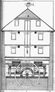
During the Revolutionary War Lord Charles Cornwallis was attracted to Charlotte and Mecklenburg County because the numerous mills along the county’s many creeks gave the promise of grain for his army.  Indeed, Long’s Mill was the object of British troops advancing out of Charlotte up Beatties Ford Road in October 1780, when they were set upon by patriots at the McIntyre Farm in the skirmish known as the “Battle of the Hornets’ Nest.” 5  After Long’s death the land including Long’s mill and farm was acquired by Colonel John “Jacky” H. Davidson in 1815-1818. 6  In about 1820 Davidson replaced Long’s mill with the Long Creek Mill.  7  It is likely that Davidson used The Young Mill Wright and Miller’s Guide.  The technical manual was written by Oliver Evans of Newport Delaware in 1795 and was updated in fifteen editions. 8 It was sold widely in America and revolutionized milling by separating and fully mechanizing the different functions of the mill on separate floors. 9  Davidson’s Mill was built during the height of the book’s popularity, and the tall Long Creek Mill resembled illustrations in the book. 


 yng_miller_drw  mill_xxx  mill_east_frame_xxx
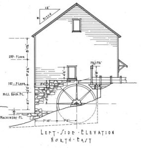
The illustration (left) from The Young Mill Wright resembles the drawings of the Long Creek Mill (center and right)


It is known that the builder of the Torance Mill (1825 and rebuilt in 1844) located a few miles north of the Long Creek Mill used The Young Mill Wright and Miller’s Guide to design that mill.  One remarkable element of the Long Creek Mill is the nearly 1,000’ millrace that extends roughly east from the mill site.  It is possible that Davidson reused the dam from Long’s mill which may have been more than 450’ upstream.  Also, The Young Mill Wright and Miller’s Guide recommends long mill races.  The long mill race and separation from the dam supposedly protected the mill from being washed away during flooding.  The long mill race may also have mechanical advantages in terms of capacity and consistent flow.  10

In his history of the Hopewell Community written in 1907, J. B. Alexander relates that before the Civil War the Long Creek Mill was a center of the community.  Taxes were collected at the mill.  Voting took place there with politicians literally speaking while standing on stumps.  According to Alexander, political campaigning at the Long Creek Mill involved fighting, and “Whiskey, cider, watermelons, and ginger cakes,” being passed out.  The mill was also the location of militia drills which Alexander described as “laughable burlesque.” 11

In 1835 Davidson moved to Maringo County, Alabama where he became very wealthy.  Through an agent he sold his Long Creek property in 1838, and in 1839 the land including the “Grist Mill and dwelling house,” was purchased by Major John H. Caldwell. 12 Caldwell was apparently successful in business.  A substantial farmer in northern Mecklenburg, he manufactured brick for the Davidson College campus buildings and for the federal mint building in Charlotte.  Caldwell also contracted his slaves to work for the North Carolina Railroad.   In 1860 Caldwell sold the property to Robert Davidson Whitley.

Robert Davidson “R. D.” Whitley was born in 1820 and was reared at Holly Bend, the plantation of Robert “Robin” Davidson.   Robin Davidson was at one time the wealthiest planter in Mecklenburg County.  Davidson owned nearly 3,000 acres and 109 slaves in Mecklenburg County in 1850, and he owned another plantation in Alabama. 13   R. D. Whitley’s mother, Jane Price Whitley, was Robin Davidson’s niece.  At some point, Whitley and his mother moved to Alabama.  They returned to North Carolina, and in 1860 R. D. Whitley purchased the land containing the Long Creek Mill. 14  We do not know if R. D. Whitley made any significant changes to the mill or to how the business was operated.  It is likely that the mill, renamed Whitley’s Mill, continued to function as a center of the rural community.  At some point in the nineteenth century a store was built across Long Creek from the mill and served as the area’s post office. 15 The Chas. Emerson & Co. Charlotte City Directory 1879-1880 gives the community around the mill the name “Martindale,” and lists R. D. Whitley as a farmer. 16 In addition to farming over 300 acres, and owning the mill and store, R. D. Whitley was active in real estate and is listed as grantee in over 30 conveyances before his death in 1900. 16  R. D. Whitley was also instrumental in the establishment of the nearby St. Mark’s Episcopal Church.  In addition to  helping to organize the church, Whitley and his wife Martha McCoy Whitley sold to the trustees some of the land for the sanctuary for a “modest sum,” and donated land for the rectory. 17

 whitleymill_ca__1915  Long Creek Mill in operation ca.1915

When R. D. Whitley bought the mill in 1860, water powered milling was in its ascendancy with nearly 14,000 thousand mills operating in the country, most of them isolated country mills like the Whitley’s Mill, with a potential to produce up to 50 barrels of flour a day. 18 The world was very different when Joseph S. Whitley took over operation of the mill and store after his father’s death in 1900. Larger mills producing flour for the domestic market and for export, such as the massive 1915 Interstate Milling Company located in the Fourth Ward in Charlotte, began to dominate.    Where there had been at least five grist mills operating in northern Mecklenburg in the nineteenth century, by 1918 the Whitley’s Mill was the only one still operating.  The 1918 “Biennial Report of The North Carolina Department of Agriculture” lists just three mills in all of Mecklenburg County: the Interstate Milling Company, Charlotte; DA Henderson, Matthews; and Whitley Mill, Long Creek.  Around 1919 the mill ceased to operate, perhaps due to a storm that damaged either the mill or the dam. 19  In 1927 the estate of R. D. Whitley was divided among his heirs. 20

In 1934 Whitley’s Mill was inventoried by the Historic American Buildings Survey.  By that point the tall building was in decay with a notably sagging roof.  The building was photographed and measured drawings were made.  A 1938 U.S. Parks Service publication used the mill’s HABS photograph to illustrate the overall deterioration of the nation’s historic buildings.  At some point after the survey work was completed, the metal waterwheel, gears and other machinery were removed.   It is believed that the mill workings were reinstalled in a reproduction grist mill south of Charlotte by Dr. Charles D. Lucas around 1935. 22

Above: the ruined Lucas Mill in Charlotte with machinery that may have been removed from the Long Creek Mill around 1935.

  1. Lee Kemp Ramsey, “The Long Creek Settlement and the Gum Branch East of the Catawba River, Mecklenburg County, North Carolina: A Genealogical Survey of the Neighbors and Allied Families of William and Nancy Ramsey,” Mecklenburg County NC Geneology Project, accessed May 20, 2012, http://www.rootsweb.ancestry.com/~ncmeckle/longcrk.htm
  2. Mecklenburg County Old Real Estate books/pages: 18-52 and 19-517
  3. J. B. Alexander, Biographical Sketches of the Early Settlers of the Hopewell Section (Charlotte: Observer Printing and Publishing House, 1897) 31.
  4. C. L. Hunter, Sketches of Western North Carolina, Historical and Biographical: Illustrating Principally the Revolutionary Period of Mecklenburg, Rowan, Lincoln, and Adjoining Counties, Accompanied with Miscellaneous Information, Much of it Never Before Published(Raleigh: Raleigh News Steam Job Print, 1877) 132, 137, 298.
  5. Dan L. Morrill, Historic Charlotte: An Illustrated History of Charlotte and Mecklenburg County (San Antonio: Historical Publishing Network, 2001) 13.
  6. Mecklenburg County deeds 20-103 and 19-56
  7. Alexander, p. 31.
  8. “Who Was Oliver Evans?” accessed on May 20, 2012 at http://www.greenbankmill.org/oliverevans.html.
  9. “Colvin Run Mill,”The Fairfax County Park Authority Division of History, Annandale, Virginia, accessed on May 20, 2012 at http://gfhs.org/local_lore/colvin_mill.htm.
  10. Dan L. Morrill, “Torrence Mill” (Charlotte-Mecklenburg Historic Properties Commission, 1978) accessed on May 20, 2012 at http://www.landmarkscommission.org/S&Rs%20Alphabetical%20Order/surveys&rtorrancemill.htm.  Alexander p.31.
  11. Alexander, p. 31.
  12. Deed 25-192
  13. “Survey and Research Report on Holly Bend,” (Charlotte-Mecklenburg Historic Properties Commission, 1974?) accessed on May 20, 2012 at http://www.landmarkscommission.org/essays/HollyBend.html.
  14. Deed 4-386
  15. Interview by Stewart Gray with Brown D. Whitley, May 7, 2012.
  16. The Chas. Emerson & Co. Charlotte City Directory 1879-1880 (Charlotte: Charlotte Observer Steam Job Print, 1879) 138.
  17. Dan Morrill, “Survey and Research Report on the St. Mark’s Episcopal Church,” (Charlotte-Mecklenburg Historic Landmarks Commission, 1983) accessed on May 20, 2012 at http://www.landmarkscommission.org/S&Rs%20Alphabetical%20Order/surveys&rstmarks.htm.  Grantee Index to Real Estate Conveyances – Mecklenburg County, NC, p. 138-139
  18. St. Mark’s S&R
  19. Robert Lundegard, “Country and City Mills in Early American Flour Manufacture and Export.”  Report for the Colvin Mill Historic Site, 2007.
  20. HABS Report  on Whitley’s Mill, State Route 2074, Charlotte vicinity, Mecklenburg, NC, 1934. Also, Interview BR Whitley.
  21. Mecklenburg County Map Book 345.
  22. Interview by Stewart Gray with Dr. Dan L. Morrill, May 15, 2012.


Architectural Description

The Long Creek Mill Ruin is located on the north bank of Long Creek in northern Mecklenburg County.  The mill ruin lays due east of Beatties Ford Road, approximately 375 feet from the edge of the pavement.  Once open farm land, the area is covered with second-growth forest.  The most substantial element of the mill ruin is the mill building’s stone foundation which sits only about ten feet from the north bank of the current channel of Long Creek.  It is composed of rough-cut granite laid in irregular courses. The walls are approximately two foot thick.  The foundation is nearly square, thirty-two feet wide by  twenty-nine feet deep.  The stone walls are broken in places, with only the northeast corner, built into the hillside, having retained its original height.  Much of the stonework appears to have fallen inward into the foundation.  The foundation was stepped with a ten foot tall section in the northeast corner.  The remainder of the foundation walls were originally eight feet tall. 

The land rises steeply to the north of the ruin and the northeast corner of the foundation is level with grade.  The southwest corner of the foundation rises from the grade five feet, and the stone work is in good condition and not obscured by ruble.  The southeast corner of the foundation is buttressed by an irregularly coursed rubble stone wall that extends toward the creek.  This wall formed the western edge of a five-foot-wide discharge chute, or tailrace.   The eastern wall of the tailrace is formed by a partially extant retaining wall of unshaped stones. 

The building foundation is bordered on the east by a wheel pit.  The wheel pit is relatively intact, perhaps because the stonework of the wheel pit was built into the hillside, as opposed to being freestanding stonework.  The pit is five feet six inches wide.  Ruble from the collapsed east wall of the foundation has partially filled the pit.  Yet even with the ruble, the rear or north wall of the pit features approximately eight feet of exposed rock.

The red square is the location of the mill ruin.  Long Creek is shown in blue.  The approximately 1,000′ millrace is depicted in pink. Evidence of dams are shown in orange.

The millrace joined the mill at the northern edge of the wheel pit.  The millrace was an elevated flume (no longer extant) where it joined the mill , but for most of its approximately 1,000 foot length, it is a channel. The existing channel width varies from six to ten feet wide, but because of erosion and sediment it is difficult to determine the original dimensions of the channel.  Portions of the millrace channel are a simple ditch.  Other sections of the millrace channel feature significant earthen retaining walls.  Other sections of the millrace channel are lined with stones.  Approximately 320 feet from the mill, the millrace shows evidence of a gate and a stone discharge flume.  This gate may have allowed the millrace to be stopped or discharged back into the creek below the dam but before it reached the mill.   The millrace has very little slope, dropping in elevation less than ten feet over its entire length.

Evidence of two dams is located along the creek in the form of rock piles and borings in the bedrock.  One dam may have been located approximately 320 feet upstream from the mill ruin.  Another possible site is located approximately 450 feet upstream of the mill ruin.

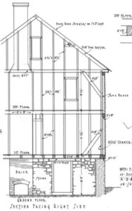
While the mill is a ruin, early-20th-century photographs of the mill exist, and measured plans for the mill were produced as part of the Historic American Building Survey (HABS) in 1934.  The stone foundation was pierced by three small window opening on the south elevation and was topped with a side-gabled two-story frame building.  The building was two bays wide and two bays deep.  A brick chimney was located on the west elevation.  The building incorporated heavy timber construction.  The roof was covered with wooden shake.  Aside from the stonework described above, no elements of the mill building appear to have survived.  Other buildings such as a house and a store were once located near the mill.  No prominent visible elements of these structures have survived.


  1. Name and location of the property:  The property known as the St. Lloyd Presbyterian Church Cemetery is located near the northwestern corner of Colony and Sharon Roads in Charlotte, North Carolina.
  2. Name address and phone number of present owner of the property: The owner of the property is:

    Grubb Properties Inc.
    Morrison Place, LLC.
    1530 Elizabeth Ave., Suite 200
    Charlotte, NC 28204
    (704) 372-5616
     

  3. Representative photographs of the property: This report contains representative photographs of the property.  Click here for photographs of the property.
  4. A map depicting the location of the property.  The UTM Coordinates of the property are 17 515966E 3890297N
  5. Current Deed Book references to the property: The most recent deed to this property is recorded in the Mecklenburg County Deed Book 16228, page 124.  The tax parcel number is 177-092-06.
  6. A brief historical sketch of the property:  This report contains a brief historical sketch of the property prepared by Hope L. Murphy.
     
  7. A brief physical description of the property: This report contains a brief physical description of the property prepared by Hope L. Murphy.
     
  8. Documentation of why and in what ways the property meets the criteria for designation set forth in N.C.G.S. 160A-400:
     
  9. Special significance in terms of its history, architecture, and/or cultural importance.  The Commission judges that the property known as The St. Lloyd Presbyterian Church Cemetery does possess special significance in terms of Charlotte-Mecklenburg.  The Commission bases its judgment on the following criteria: 1) The St. Lloyd Presbyterian Church Cemetery is a locally large and well-preserved burial site of African Americans that contains graves dating from  roughly 1868 until about 1926; 2) the St. Lloyd Presbyterian Church Cemetery is located in an otherwise highly-developed section of Charlotte and is the one of the few reminders of the rural farming community that once stretched along this section of Sharon Road; and 3) the St. Lloyd Presbyterian Church cemetery is the only surviving remnant of St. Lloyd Presbyterian Church, a Christian congregation that established its own house of worship in response to the newly-gained liberation of African Americans from bondage.
  10. Integrity of design, setting, workmanship, materials, feeling and/or association: The Commission contends that the physical description that is included in this report demonstrates that the St. Lloyd Presbyterian Church Cemetery meets this criterion.
  11. Ad Valorem Tax Appraisal:  The Commission is aware that designation would allow the owner to apply for an automatic deferral of 50% of the Ad Valorem taxes on all or any portion of the property which becomes “historic property.”  The current appraised value of the 1.0164 acres of land is $318,700.  There are no improvements on the property.  The property is zoned R-17MF.


Date of preparation of this report: April 8, 2004

Prepared by: Hope L. Murphy

Historical Overview

One can best appreciate the cultural significance of the St. Lloyd Presbyterian Church Cemetery by examining the plight of African Americans in Mecklenburg County in the years immediately preceding and following Emancipation.  In 1860 slaves accounted for approximately 40% of Mecklenburg County’s population.[1]   These bondsmen and bondswomen tended, unlike those in Virginia and South Carolina coastal regions, to live on small plantations, and the slave owners in Mecklenburg County most often owned a relatively small number of bondspeople.  About twenty-five percent of the white population of Mecklenburg County held African Americans as slaves, the majority of whom worked as farmhands or domestics, while a small minority labored in the County’s gold mines.  In 1860 only 139 free blacks lived in the Charlotte.[2]

            Whites placed onerous controls on free blacks and enslaved blacks during the decades leading up to the Civil War.  Slaves were barred from the streets after 9:30 p.m., were not allowed to buy or sell liquor, and could not assemble without the expressed permission of the mayor or town commissioners.  Free blacks were limited both by local and state codes, including the Free Negro Code of 1830, which attempted to prevent free blacks from having contact with both slaves and abolitionists, restricted their movement into and out of the state, and forbade whites from teaching bondspeople to read and write.  By 1835 the North Carolina General Assembly had also stipulated that free blacks could no longer vote.[3] Charlotte’s City commissioners placed severe restrictions on local free blacks and enslaved blacks.  The minutest details of black life were circumscribed.  For example, blacks, free and slave, were prohibited from smoking, carrying weapons, and from being employed as clerks or retailers.  In sum, whites attempted to prevent African Americans from obtaining even the most rudimentary sense of independence and self-worth in the pre-Civil War era.

     After the Civil War, newly-freed blacks relished the opportunity to build families not subject to white control and churches that were similarly independent.  Kathleen Hayes, a freedwoman, railed against the practice of seating African Americans in the balcony of Charlotte’s First Presbyterian Church and called upon the black members of the congregation to “come out of the gallery and worship God on the main floor.”  The Northern Presbyterian Church responded to such urgings by establishing the General Assembly’s Committee on Freedman on June 21, 1865, which sent 40 white missionaries and teachers to the South.

      These teachers and missionaries faced many difficulties, including inadequate funding and rejection and hostility at the hands of many of the local whites.  Undaunted, preachers like Reverend S.C. Alexander came from Pittsburgh to help Kathleen Hayes and other disaffected blacks establish Seventh Street Presbyterian Church, now First United Presbyterian Church.[4]  Alexander joined with fellow whites Sidney Murkland and Willis L. Miller in October 1866 to create the Catawba Presbytery, the first all-black Presbytery in the United States.  These courageous men labored tirelessly to assist African Americans in creating several churches in Mecklenburg County – including McClintock Church, Murkland Church, Woodland Church, and St. Lloyd Presbyterian Church.  These newly-founded congregations provided places of worship for those African Americans who wanted to remove themselves from their former white-controlled churches because of the demeaning treatment accorded black members there.[5] Black congregants in white-controlled churches were listed separately on membership rolls, were forced to sit in separate sections, and were denied leadership positions.

Another primary need among freedmen was education.  In response, the Committee on Freedmen began to establish primary schools, secondary schools, and colleges.  Alexander and Miller helped to launch Biddle University, which was founded for the expressed purpose of “training of colored preachers, catechists and teachers of their own race.” [6]  Catechists, in this period, were candidates for the ministry.  They were often older men with little or no formal education. Many walked from the 14 neighboring African American Presbyterian Churches, like St. Lloyd Presbyterian Church, that eventually arose in the area.  They often traveled a distance of 5-10 miles each way, from the churches where they performed duties, in the absence of more formerly trained ministers.[7]

Biddle was named for Mrs. Henry Biddle of Philadelphia who made a donation to the school in the name of her husband who was killed in the Civil War[8].  Biddle, which is now named Johnson C. Smith University, has been a cornerstone of the intellectual, social, and spiritual life of Charlotte’s African-American community.  It has also had remarkable regional influence on the Presbyterian Church.  A survey conducted in 1970 found that 60 percent of Black Presbyterian clergy in the Southeastern United States were Biddle/Smith graduates. [9] Biddle would provide at least one of the ministers at St. Lloyd Presbyterian Church.  He was Rev. Hercules Wilson, a 1911 graduate of Biddle Theological Seminary.  St. Lloyd Presbyterian, as a small country church, was most likely Wilson’s first assignment.  Later he would serve at the larger and more socially prestigious Woodlawn and Brooklyn Churches.


Rev. Hercules Wilson (Far Right)

Photo courtesy of the Inez Moore Parker Archives & Research Center,  Johnson C. Smith University

The Founding of St. Lloyd Presbyterian Church


In October 1867 a group of African American members of Sharon Presbyterian Church appeared before the Church Elders.  According to the minutes of that Session, these black members requested “advice and aid in  building a house of worship for the colored people.”[10]  Though the names of the petitioners, or the church they wished to establish, are not in the Sharon Presbyterians minutes, it is believed that these African American members were the subsequent founders of St. Lloyd Presbyterian Church.[11]


These former slaves, like others all around them, sought to define their freedom within their own institutions and houses of worship.  Reverend Willis L. Miller, aforementioned as one of the founders of the Catawba Presbytery and Biddle University, helped the charter members of St. Lloyd Presbyterian establish their new church in the Sharon community.  Miller requested that the Elders of Sharon Presbyterian Church dismiss without censure the African Americans who wished to leave.  Miller’s request was granted during the Session meeting on October 20, 1867, with the following words:


“It is resolved by this Session that the names of all those colored members, who have gone into this aforesaid organization, be other (sic) are hereby, omitted from the Roll of Members of this Church without censure, with the prayer that the Great Head of the Church may go with and bless these our colored brethren in their new church relations.” [12]

 
Rev. Willis L. MillerPhoto courtesy of the Inez Moore Parker Archives & Research Center,  Johnson C. Smith University

On February 18, 1868, five trustees of St. Lloyd Presbyterian Church signed a deed to purchase one acre of land in Sharon Township from Jonathan K. Ray.[13]  This parcel of land was located about a mile north of Sharon Presbyterian Church, also on Sharon Road.  The diamond-shaped piece of property was purchased for $25.00 for the purpose of erecting the congregation’s first church building and for providing a burial ground.  The deed stipulated that in the event of the dissolution of the church, ownership of the property would revert to the Catawba Presbytery.  When St. Lloyd Presbyterian Church was founded, Sharon Road was dirt; and according to David Lockwood, a white long-time resident of the Sharon community, it was not a main thoroughfare but “led nowhere.”  Colony Road was then only a narrow dirt path that led to the farmlands behind the Church grounds. [14]


In the “Jim Crow” era, St. Lloyd Presbyterian Church would have served many of the needs of its congregation. Most of those who attended St. Lloyd Presbyterian Church were poor and worked primarily as laborers, farmers, and domestics.  With educational opportunities limited, many remained uneducated.  When the Trustees of Lloyd sold the property in 1926, two out of five of the trustees were illiterate, as evidenced by their making their mark, in lieu of a signature.   The harshness of lives of the church members is also evident from their causes of death.  Many died early in life of diseases, like Pellegra (a vitamin deficiency) and lung ailments like pneumonia and tuberculosis, which are now largely curable.

 Rev. Wilson
Rev. Hercules Wilson


Much time would have been spent in the church, which served, as most country churches, black and white, as a place to receive spiritual salve in difficult times and as a social center for the community.  David Lockwood and Mary Ruth Gibson, the latter also a white resident of the Sharon community, each fondly recount that his and her  families would sit on their front porches in summer evenings and listen to the members of St. Lloyd Presbyterian singing hymns. [15]  C.C. Caldwell, Mary Ruth Gibson’s brother, recounts that his father attended a wedding in the 1920’s at St. Lloyd Presbyterian Church. The bride was Sara Alexander, whose father was an attorney. [16] Tom Kirkpatrick, another white resident of Sharon, recounts with humor that Lloyd parishioner Lucinda Davis, who was in his family’s employ along with her husband Walter, often lectured Kirkpatrick’s father on how to be a better Christian.[17]


When the Church property was sold to the Morrisons in 1926 the congregation moved to a new location in Grier Heights, on what is now Wendover Road.  Grier Heights was, and still is, a primarily African American neighborhood.  St. Lloyd Presbyterian’s move from Sharon Township to Grier Heights is tangentially related to broader trends that were present in Charlotte and Mecklenburg County  during the “Jim Crow” era.  Neighborhoods that had for many years showed a “salt and pepper” pattern – where blacks and whites lived, worshiped, and worked in close proximity – became after Reconstruction increasingly segregated.[18]


It is clear that in the half-century following the Civil War St. Lloyd Presbyterian Church was central to life in Sharon Township.  In this rural area it provided spiritual guidance, acted as a social outlet for African Americans, and provided a forum for developing black leadership.   It also served, in a time characterized by racial animosity, as a place of refuge, comfort, and encouragement for African Americans.


Architectural/Physical Description

             The St. Lloyd Presbyterian Cemetery is located near the northwestern corner of Sharon and Colony Roads in  Charlotte, North Carolina.  Once part of the rural township of Sharon, the area has now become one of the busiest and most sought-after areas for residences, shopping, and business.  The St. Lloyd Cemetery is situated on a largely level, diamond-shaped one-acre lot, which extends along Colony Road to a set of apartment homes.  Most of the parcel is covered with mature trees, except for the approximately one-half-acre that contains the graves; there younger trees grow, and the ground is covered with periwinkle.  Periwinkle was a common ground cover used in older cemeteries.  Its invasive root system prevents other weeds from growing, and its purple flower acts as a decorative ground cover.  It is probable that the plants that now exist there  are offshoots from those planted by the St. Lloyd Presbyterian Church congregants more than 150 years ago. 

      Seventy-eight graves have been identified at the site[19].  These depressions are about two feet wide and range in length from six feet to between four and five feet.  Adults are interred in the larger depressions, and the smaller ones contain the remains of children.  The graves, generally oriented from east to west,[20] are located close to Colony Road and are grouped in what must be family burial plots.[21]  The graves at the site likely date from about 1868, when the church property was purchased, until  roughly 1926, when the property was sold to Cameron and Sarah Morrison.  The Morrisons purchased the property as part of a larger parcel that would become part of Cameron Morrison’s grand “gentleman’s farm”  named Morrocroft.

       Very few grave markers remain, and none has an inscription.  The ones that do survive are field stones.  Most likely some of the markers were fashioned from wood and have since deteriorated.  There is anecdotal evidence that larger stone markers may have been in the cemetery but were later relocated.[22]  An explanation of any motivation behind such a move does not exist, since no graves were to be relocated and since the property was, by deed, to remain an undisturbed gravesite in perpetuity[23].  It is not clear whether the Morrisons agreed to maintain the cemetery.  Mary Ruth Gibson recounts that as a child her brother C.C. Caldwell would compel her to visit the cemetery and help him pick the weeds that had grown up around the site.[24]


There is no visible evidence of the church building remaining.  As of this date it is unclear what happened to the church structure, though there is anecdotal evidence that it burned down.  Residents of the area recount that the church was located approximately 200 yards from Sharon Road and faced northeastward, toward what is now uptown Charlotte.  The church, according to David Lockwood, was a small, one-story wooden structure, with a simple bell tower in the front.


Click here to read about Weeping Willow, another historic African American Cemetery that was once the Weeping Willow A.M.E. Zion Church Cemetery.

[1] Dan L. Morrill, A History of Charlotte and Mecklenburg County, Chapter 4.  An on-line resource:www.danandmary.com/historyofcharlotte.htm.  Ms Murphy produced this report as a student intern.  She is enrolled in the Public History Program at the University of North Carolina at Charlotte.

[2] Janette Thomas Greenwood, Bittersweet Legacy: The Black and White “Better Classes” in Charlotte, 1850-1910. (Chapel Hill: The University of North Carolina Press, 1994), p. 21.

[3] Ibid, 22.

[4] Ibid.

[5]  Interestingly, Rev. Miller had, prior to his conversion, been a slaveholder, and had fought to maintain the institution of slavery.  (Inez Moore Parker, Historical Narrative, The Biddle-Johnson C. Smith University Story, Charlotte: Charlotte Publishing, 1975 p. 94)  D.G. Burke, “The Catawba Story 1866-1980: A brief History of the Catawba Presbytery.  Sponsored by the Historical Committee of the Catawba Presbytery, United Presbyterian Church, USA, 1981”.  From the Inez Moore Parker Archives, Johnson C. Smith University.

[6] Biddle University Report of 1871.  From the Inez Moore Parker Archives, Johnson C. Smith University.

[7] Biddle University Report of 1869.  From the Inez Moore Parker Archives.

[8] Greenwood, 44.

[9] Background and Status Survey United Presbyterian USA Black Ministers, Feb 1971. The Inez Moore Parker Archives and Research Center, Johnson C. Smith University.

[10] Minutes of the Sharon Presbyterian Church Session, October 19, 1867.

[11] The prevalence of family names that appear both among black congregants at Sharon and congregants at Lloyd, along with the close ties between known members of Lloyd and living informants from Sharon, lead the writer to this conclusion.

[12] Minutes of the Sharon Presbyterian Church Session, October 20, 1867.

[13] The church has been called Lloyd and St. Lloyd’s alternatively.  Though all deeds are registered in the name of Lloyd Presbyterian, death records list the Church as St. Lloyd’s.

[14] Interview with David Lockwood – Febuary 24, 2004.

[15] Interview with Mary Ruth Gibson – February 19, 2004, and Lockwood Interview.

[16] Interview with C.C. Caldwell – March 2, 2004.

[17] Interview with Tom Kirkpatrick – February 24, 2004.

[18] http://danandmary.com/hisof charlottechap9new.htm

[19] Most of the names of those buried at Lloyd Presbyterian Church are not known; the following names were obtained from death certificate searches.  Mecklenburg County only maintains death certificates from 1913 making research, using death certificates, prior to this date impossible.

NAME AGE AT DEATH OCCUPATION DATE OF DEATH & CAUSE DEATH CERTIFICATE NUMBER
William McKee 63 years Laborer October 9, 1917

Edema of Lungs

#665
Eugenia Kirkpatrick 38 years Domestic July 11, 1918

Pellegra

#313
Carie Walker About 18 years December 23, 1918

Pneumonia

#47
Becky Sumple Walker 65 years Laborer July 7, 1920 Neuralgia of the heart #114
Winiah Knox 57 years Laborer Mitral Regurgitation #1005
Louise Campbell 11 months March 17, 1921

Whooping Cough

#1158
Joe Mackey 48 years Laborer December 1, 1921

Cause Unknown

#280
Robert Harris About 46 years Farmer December 5, 1921

Tuberculosis

#274
Robert Stewart 13 years Farmer January 18, 1922

Tuberculosis

#283
Walter Phiser 52 years Farmer June 4, 1922

Cause Unknown

#287
June Price About 60 years Farmer November 16, 1922

Pellegra

#290
“Baby” Alexander Stillborn July 19, 1923 #207
Mamie Walker 42 years Housewife January 23, 1923


#153
James Harris 9 months May 27, 1924 Colitis # 268
Thomas Watson 7 years
“Baby Boy” Price Stillborn January 21, 1926


[20] “An Archeological Reconnaissance of the Lloyd Presbyterian Church Cemetery: Charlotte, Mecklenburg County, North Carolina.”  J. Alan May, August 1993.

[21] May, p. 14.

[22] C.C. Caldwell, recalled that as a child in the 1930’s that as many as 30 headstones were still standing in the cemetery. Mr. Caldwell conjectures that the stones may have been stolen by vandals.

[23] Mecklenburg County Deed Book 617, page 440.

[24] Gibson Interview.


Little Rock A.M.E. Zion Church

Click here to view the photo gallery of the Little Rock A.M.E. Zion Church.

This report was written on February 4, 1981.

1. Name and location of the property: The property known as the Little Rock A.M.E. Zion Church is located at 403 N. Myers St. in Charlotte, NC.

2. Name, address, and telephone number of the present owner and occupant of the property:
The present owner of the property is:
City of Charlotte
600 E. Trade St.
Charlotte, N.C. 28202

Telephone: (704) 374-2241

The present occupant of the property is:

Little Rock A.M.E. Zion Church
403 N. Myers St.
Charlotte, N.C. 28202

Telephone: (704) 334-3782

3. Representative photographs of the property: This report contains representative photographs of the property.

4. A map depicting the location of the property: This report contains a map which depicts the location of the property.

5 Current Deed Book Reference to the property: The current deed to this property is recorded in Mecklenburg County Deed Book 4210, page 954. The original deed to this property on behalf of Little Rock A.M.E. Zion Church is recorded in Mecklenburg County Deed Book 60, page 395. The Tax Parcel Number of the property is: 080-104-08.

6. A brief historical sketch of the property:

Little Rock A.M.E. Zion Church was established in the early 1870’s, as the black people of Charlotte were struggling to fashion an identity outside of the shackles of slavery. Its founder was Thomas Henry Lomax (1832-1908), a remarkable and resourceful human being.1 A native of Cumberland County, North Carolina, Lomax had come to Charlotte to advance the interests of the African Methodist Episcopal Church, a denomination which had its roots in the antebellum North but which began to penetrate coastal North Carolina when Union forces occupied Beaufort and New Bern. After the Civil War, A.M.E. Zion preachers moved inland to rally the former slaves to a Christian institution which was entirely devoid of white influence or power.2 The church reached Charlotte about May 1865, when Edward H. Hill arrived and founded Clinton Chapel, the first black church in the city. It stood on S. Mint St. between First and Second Streets.3 Thomas Henry Lomax came to Charlotte about 1873. Six years earlier, in 1867, he had received his license to preach. Initially, he labored in eastern North Carolina, where he demonstrated the administrative skill and adroitness which were to characterize his entire career. It is not surprising, therefore, that Lomax was assigned to Clinton Chapel in Charlotte, an important frontier for the African Methodist Episcopal Church. Between 1873 and 1876, Lomax worked feverishly to build upon the foundation which E. H. Hill and others had started. In addition to increasing the size of Clinton Chapel by approximately seven hundred members, he established a second church in Charlotte, Little Rock A.M.E. Zion Church.4

Little Rock Church originally occupied a parcel on S. Graham St. between Second and Third Streets.5 In 1876, Lomax became a Bishop and journeyed to Canada as a missionary. Although Lomax served the church in several capacities during the decades that followed, he maintained a strong connection with Charlotte and with Piedmont North Carolina. He was instrumental, for example, in having the A.M.E. Zion Publishing House locate in this community. Also, Bishop Lomax was on the committee which selected the site in Salisbury, N.C., for Livingstone College, an A.M.E. Zion institution of higher education. Not surprisingly, he received the Doctor of Divinity Degree from Livingstone.6 Bishop Lomax resided in Charlotte during the final years of his life. He died there on March 31, 1908.7 Indicative of his standing in the community was the fact that the Charlotte Observer commented editorially upon his death. Indeed, the acclaim which he received from the white leadership of the city was almost unknown in those days of intense and prevailing racial segregation. “In the death of T. H. Lomax of this city, the colored race and the community lose a valuable member and the A.M.E. Zion Church a shining light,” the newspaper asserted. “His example and counsels always made for good and by all colors and classes his death is to be regretted.”8

Perhaps some of the esteem which Bishop Lomax enjoyed among his white compatriots was due to his abilities as an entrepreneur. He invested heavily in real estate in Charlotte, especially in Second Ward, and possessed an estate of approximately $70,000 at the time of his death.9 “He had remarkable business talent,” the Charlotte News proclaimed, “and set an example to his people of how power and respect come to a man from thrift and industry.”10 Bishop Lomax is buried in Pinewood Cemetery in Charlotte, N.C.l1 Little Rock A.M.E. Zion Church prospered and flourished in Charlotte. In June 1884, the congregation purchased a lot at N. Myers and E. Seventh Sts. and began the construction of a new house of worship.12 It is reasonable to assume that the people of Little Rock Church abandoned their original building on S. Graham St. and moved to First Ward, because the largest and oldest A.M.E. Zion church in Charlotte, Clinton Chapel, was only about a block away from the initial site.13 By 1889, activities were in full swing at the First Ward location.14 So successful was Little Rock A.M.E. Zion Church in ministering to the black people of the neighborhood that a larger edifice replaced the first building in 1893.15

In order to appreciate and understand the function of the black church in Charlotte in the late nineteenth and early twentieth centuries, one must realize the difficulties which the customs and attitudes, not to mention the legal strictures, of white supremacy and racial segregation placed in the path of black men and women. Imagine, for example, how the black citizens felt when a play entitled “The Nigger” was performed on the stage of the elegant Academy of Music on S. Tryon St.16 Fancy how they reacted emotionally to the announcement that the owners of Lakewood Park, a popular amusement complex, would not extend the fall season for a week in 1910, so the black residents of Charlotte could visit the facility, because the “fear existed that such a course might injure the resort in some manner, or might lesson the prestige.”17 At almost every turn, the black men and women of Charlotte encountered events which threatened their sense of self-esteem. In November 1911, the Board of School Commissioners announced that it was abandoning plans to construct a black school in Third Ward because of the “objections which have been forthcoming from the citizens.”18 In April 1911, black Sunday School teachers were invited to the Mecklenburg County Sunday School Association, but they had to sit in the balcony.19 Within this cultural milieu, the black church served as a haven from the white man; there black men exhorted their congregations to persevere in the face of adversity and scorn. The African Methodist Episcopal Church provided a service whereby congregations could obtain architectural plans from offices in Philadelphia, PA.20

When S. D. Watkins, minister of Little Rock A.M.E. Zion Church from 1900 until 1906, undertook to build more imposing structure for his congregation than the wooden buildings which had housed the people theretofore, he decided to raise the funds to secure an architect.21 W. R. Douglas succeeded Watkins as minister in 1906 and superintended the building program. By May 1908, the plans were drawn and the congregation had raised $2000 in its building fund.22 The building permit was issued in September 1910, and the new church was finished by June 1911. The cost of the new, brick house of worship was $20,000.23 This phenomenal sum of money for a black congregation of that era was raised entirely by the congregation itself. “Built by the subscription of Negroes entirely,” boasted the Greater Charlotte Club, an influential white organization, “this structure is a monument to the thrift and religious inclinations of Charlotte negroes.”24 By pursuing the more difficult and expensive route of securing a local architect, the members of Little Rock A.M.E. Zion Church made a more forthright statement about their standing in the community than would have been the case if they had ordered a standard design from the A.M.E. Zion offices in Philadelphia. The architect of the new edifice was James Mackson McMichael (1870-1944).25 A native of Harrisburg, Pa., McMichael was the architect of several imposing buildings in this community, including the North Carolina Medical College Building, the old First Baptist Church (now Spirit Square), East Avenue Associate Reformed Presbyterian Church, St. John’s Baptist Church, First Associate Reformed Presbyterian Church, and Myers Park Presbyterian Church.26 Unlike these affluent white congregations, however, the people of Little Rock Church had raised the money to hire the leading church architect of Charlotte at great financial sacrifice to themselves.27 The official history of the Little Rock A.M.E. Zion Church reveals that the text for the first sermon in the new building was taken from Nehemiah 4:6: So built we the wall; and all the wall was joined together unto the half thereof; for the people had a mind to work.28

Over the years, Little Rock A.M.E. Zion Church has played a leading role in shaping the destiny of the black community of Charlotte, NC. Happily, the exterior of the building is essentially unchanged from the original. Presently, the congregation is erecting a new sanctuary across Myers St. from the 1910-11 edifice. Hopefully, the old building will survive as a reminder to the contributions of individuals such as Bishop Thomas Henry Lomax, who guided his people toward a new and better tomorrow.


NOTES:

1 Charlotte Observer (April 1, 1908), p. 8.

2 J. W. Hood, One Hundred Years of the African Methodist Episcopal Church (New York: A.M.E. Zion Book Concern, 1895 , pp. 191-195.

3 Ibid., p. 297. Map of Charlotte: F. W. Beers (1877).

4 Charlotte Observer (April 1, 1908), p. 8. William J. Walls, The African Methodist Episcopal Zion Church: Reality of the Black Church (Charlotte, NC: A.M.E. Zion Publishing House, 1974), p. 580.

5 Map of Charlotte: F. W. Beers (1877).

6 Charlotte Observer (April 1, 1908), p. 8.

7 Ibid.

8 Charlotte Observer (April 2, 1908), p. 4.

9 Charlotte Observer (April 1, 1908) , p. 8.

10 Charlotte News (April 1, 1908), p. 9.

11 Charlotte Observer (April 1, 1908), p. 8.

12 Mecklenburg County Deed Book 60, p. 395.

13 Map of Charlotte: F. W. Beers (1877).

14 John Hirst and Dudley G. Stebbins, eds., Hirst’s Directory of Charlotte (Charlotte: Hirst Printing and Publishing House, 1889), p. 35.

15 Mecklenburg County Deed Book 91, p. 366.

16 Charlotte News (January 6, 1911), p. 9.

17 Charlotte Evening Chronicle (September 21, 1910), p. 6.

18 Charlotte Observer (November 10, 1911), p. 6.


19 Charlotte Observer (April 21, 1911), p. 5.

20 Star of Zion (September 7, 1911), p. 3.

21 Official Journal of the Twenty-Third Quadrennial Session of the General Conference of the African Methodist Episcopal Zion Church, pp. 149-150. The Journal states that the plans were drawn “by one of the leading architects of the city.”

22 Ibid.

23 Charlotte Evening Chronicle (October 29, 1910), p. 9. Mecklenburg County Deed Book 271, p. 648. Official Journal of the Twenty-Fourth Quadrennial Session of the General Conference of the African Methodist Episcopal Zion Church, p. 345. 24. Charlotte: The Hydro-Electric Centre (Charlotte: The Greater Charlotte Club, 1913). This source contains an early photograph of the building.

25 Interview of David S. McMichael by Dr. Dan L. Morrill (January 22, 1981). Mr. McMichael, who lives in Alexandria, Va., has the original drawings of the building.

26 Charlotte News (October 2, 1907), p. 5. Charlotte Observer (October 4, 1944), 2nd. sec., p. 1. Charlotte Evening Chronicle (February 23, 1911), p. 9. 27. Eighty Sixth Anniversary Little Rock A.M.E. Zion Church, p. 6. 28. Ibid.


7. A brief architectural description of the property: This report contains a description prepared by Jack O. Boyte, A.I.A.

8. Documentation of why and in what ways the property meets the criteria set forth in N.C.G.S. 160A-399.4:


a. Special significance in terms of its history, architecture, and/or cultural importance: The Commission judges that the property known as the Little Rock A.M.E. Zion Church does possess special significance in terms of Charlotte-Mecklenburg. The Commission bases its judgment on the following considerations: 1) the building was designed by J. M. McMichael, an architect of local and regional importance; 2) the structure is the only known building which McMichael designed for a black client in Charlotte; 3) the building is the most architecturally sophisticated of the older black churches in Charlotte; 4) the only other historic A.M.E. Zion church building in the center city, Grace A.M.E. Zion Church, has already been designated as “historic property” — Clinton Chapel has moved to a suburban location and the original building is not extant; and 5) Little Rock A.M.E. Zion Church has occupied a place of great importance in the cultural and social life of the black community.

b. Integrity of design, setting, workmanship, materials, feeling and/or association: The Commission judges that the architectural description included in this report demonstrates that the property known as the Little Rock A.M.E. Zion Church meets this criterion.

9. Ad Valorem Tax Appraisal: The Commission is aware that designation would allow the owner to apply annually for an automatic deferral of 50% of the Ad Valorem taxes on all or any portion of the property which becomes “historic property.” The current Ad Valorem tax appraisal of the .357 acres of land is $18,680. The current Ad Valorem tax appraisal of the building is $43,270. The property is exempted from the payment of Ad Valorem taxes. The property is zoned B2.


Bibliography

Charlotte Evening Chronicle

Charlotte News

Charlotte Observer

Charlotte: The Hydro-Electric Centre (Charlotte: The Greater Charlotte Club, 1913).

Eighty Sixth Anniversary Little Rock A.M.E. Zion Church.

John Hirst and Dudley G. Stebbins, eds., Hirst’s Directory of Charlotte (Charlotte: Hirst Printing and Publishing House, 1889).

J. W. Hood, One Hundred Years of the African Methodist Episcopal Church (New York: A.M.E. Zion Book Concern, 1895) .

Interview of David S. McMichael by Dr. Dan L. Morrill (January 22, 1981).

Map of Charlotte: F. W. Beers (1877).

Official Journal of the Twenty-Third Quadrennial Session of the General Conference of the African Methodist Episcopal Zion Church.

Records of the Mecklenburg County Register of Deeds Office.

Records of the Mecklenburg County Tax Office.

Star of Zion.

William J. Walls, The African Methodist Episcopal Zion Church: Reality of the Black Church (Charlotte, N.C.: A.M.E. Zion Publishing House, 1974).
Date of Preparation of this Report: February 4, 1981.

Prepared by: Dr. Dan L. Morrill, Director
Charlotte-Mecklenburg Historic Properties Commission
3500 Shamrock Dr.
Charlotte, N.C. 28215

Telephone (704) 332-2726


Architectural Description
 

The Little Rock AME Zion Church building is a striking medley of turn-of-the-century revival architectural styles. Romanesque arches combine with neo-colonial trim details and domed bell towers to create a unique and handsome church building, a building which has enriched Charlotte’s First Ward community for nearly three quarters of a century. Its hillside site is visible from several adjoining neighborhoods, and the church is firmly implanted in early memories not only of First Ward residents, but of many who grew up in Elizabeth, Myers Park or elsewhere in eastern Charlotte. Bordering East Seventh Street where it crosses Myers, the large rectangular red brick structure rises from a half basement some thirty feet to a steep tripped roof. Exterior front and side facades are symmetrical and feature a series of cast stone trimmed window and door openings as well as carefully executed Adamesque wall and roof design elements of wood. The entrance facade has a three bay balconied portico in the center and large square corner stair towers at each side. The front wall of each tower has twin windows on three levels. Basement sash are small square projecting vents with opaque, patterned glass. At the second, or main sanctuary level, tall double hung sash windows are set in masonry openings with lintels of brick jack arches. Shorter double hung mezzanine windows have rounded brick arch openings defined by corbeled brick eyebrows.

At the tower side walls single windows at each level repeat, in a smaller scale, the details of front units. The southern tower touches the Seventh Street sidewalk, and here there is a prominent secondary entrance. Double doors open onto a landing from which stairs rise a half flight to the narthex or drop a half flight to the basement. Clear glass panels fill the upper half of each door and flood the stair with natural light. The entrance opening has a low arched stone head. This arch is a continuation of a stone belt course which bands the entire structure at the main floor level. Soaring high above the corners, twin octagonal bell cupolas complete the tower compositions. With segmented curved roofs which rise steeply to knob finials, the domed roof towers are dominant elements in this eclectic architectural composition. The eight sided belvederes have Palladian arches in each segment with wooden casing, spring blocks and arch keys. Both are open to the weather on all sides, yet only the south tower shelters a bell. Simulated stone entrance stairs matching the front portico in width, begin at the edge of the Myers Street sidewalk and rise a dozen steps to a recessed entrance platform. In each bay tall panelled doors open to a narrow narthex. Over the doors arched transom windows are glazed with lead patterned stained glass. Fluted Ionic columns rest on square brick pedestals at the top of the entrance steps. Above this, the flat portico roof has a broad molded entablature supporting a projecting denticular cornice. The balcony balustrade is segmented to match the three bays of the portico. Solid wood panels occur over each column and slender balusters support a molded intermediate rail.

Set behind the balcony the mezzanine wall has three equally spaced double hung sash windows. Over these windows is a projecting pedemented gable featuring molded raking cornices. The Seventh Street facade, which is repeated on the uphill side of the church, is a lofty wall of red brick laid in running bond. This wall rises more than forty feet from a grass sidewalk strip to a modest projecting cornice where a narrow bed mold with dentils is the only elaboration. At the molded eave line a built in gutter anchors a steeple sloped slate roof. At the main floor level, there is a wide band of simulated stone which circles the entire building perimeter. Below this belt line, five shallow windows with low arched heads are spaced evenly in the basement wall. An exterior basement entrance was inserted in the rearmost window opening in subsequent years. The wall surface above the stone belt course is divided equally by five monumental windows. These tall openings have twin sash lower units with mullion dividers. Above are half circle stain black transoms and brick Romanesque arches. Three large gable vents are centered side by side in both sloping long side roof surfaces. Designed as architectural features, these gables have raking cornices which shelter horizontal wood louvers. Wood surrounds for the triangular louvered vent panels are sawn in two cusp, trefoil, arch forms.

Rear facade details are generally consistent with those found elsewhere. A low-roofed wing extends along the Seventh Street frontage and includes a pastor’s study and choir robe room. Simulated stone steps rise from the sidewalk to a simply detailed secondary entrance at this wing. Centered in the high rear facade is a gable roof where another triangular louvered vent has a trefoil wood surround. Important among the extraordinary features which adorn the exterior of the church is the consistent use of leaded stained glass in the windows. On all four sides numerous and varied glazed openings flood the interior with subdued light warmed by multi-colored glass. Following the basic rectangular exterior building form, the church plan is balanced along a central axis. From the main entrance on Myers Street, one enters a low ceilinged narthex flanked by open stair towers. The inside narthex wall faces the nave with a center window and double doors at each side, all set in arched openings. Rising in five runs from basement to mezzanine levels the tower stairways are bordered by mill crafted balustrades and molded wall panels. Sturdy turned balusters support a heavy molded wooden rail. Large square corner newel posts at each landing have recessed side panels and molded caps.

Designed to focus on a center pulpit platform and raised choir chancel, the vaulted nave retains much of its original classical trim, though the pulpit and pew furnishings have been replaced. Wall and ceiling surfaces are smooth plaster interrupted only by a projecting chair rail which borders the interior at the window sill line and a wide crown mold at the ceiling. Plaster arches divide the nave into equally spaced window bays. The curved ceiling is likewise segmented by lowered plaster arches. At the rear of the nave a sloping gallery opens from above the narthex. Here, on high-stepped platforms, are examples of the original church pews. Fabricated of dark stained pine, the heavy seats are typical turn-of-the-century molded and carved furnishing produced in local planing mills.

A dominant feature in the main auditorium is an array of brass organ pipes set behind the chancel in a shallow plastered alcove. This instrument with its fine old console is a significant element in the preserved interior. The Little Rock Church building is a remarkable reminder of an exuberant expression of faith by the earlier congregations. This intricate old classic is important not only to First Ward but the entire community and should be carefully preserved.


Liddell-McNinch House

This report was written on October 20, 1975

1. Name and location of the property: The property known as the Liddell-McNinch House is located at 551 North Church Street, Charlotte, North Carolina 28202.

2. Name, addresses, and telephone numbers of the present owners and occupants of the property: The present owner of the property is: the S. S. McNinch Heirs.

The present occupants of the property are: Kiss Mattie McNinch and Mr. John K. Slear, widower of Julia McNinch Slear

Telephone: 332-4391

3. Representative photographs of the property: Two photographs of the structure are included in this report.

4 A map depicting the location of the property: This report contains a map depicting the location of the Liddell- McNinch House.


Click on the map to browse
5. Current Deed Book reference of the Property: Mecklenburg County Deed Book 222, page 591; Tax Book 78, page 35, lot 13.

6. A brief historical sketch of the property:

The property at 511 North Church Street was bought by Vinton Liddell in 1891 for $3,000 from G. F. Jason who was commissioned to sell the land according to the case of Laura B. Davidson vs. Montrose Davidson. (Mecklenburg County Deed Book 77, page 585 ) The Beers Map of 1877 shows a structure on the lot. It is not known whether this structure was burned, moved, or torn down, but, according to Mr. J. W. McClung, Jr., whose family lived across Church Street, the house that stands on that lot now was built by Mr. Liddell. Mr. McClung notes that Mr. Liddell, officer of a machine company was teased about the construction price of his house which was reported to be $35,000. In 1904 Mr. and Mrs. Liddell sold the property to Charles M. Patterson, a bachelor, who paid $18,000 for it. The deed (Mecklenburg County Deed Book 198, page 124) states that the property was “known as the Home Place of Vinton Liddell”. Mr. Patterson sold the property to S. S. McNinch in 1907 (Mecklenburg County Deed Book 222, page 591 )


Mr. McNinch served as Mayor of Charlotte from 1905 to 1907. In 1909 he traveled to Washington, D. C , to personally invite President William Howard Taft to speak at the Charlotte- Mecklenburg May 20th celebration. President Taft accepted the invitation, came to Charlotte and visited in the McNinch home on North Church Street.

The Liddell-McNinch house is of the Queen Anne/Shingle style. Participants of the Fourth Ward Preliminary Survey sponsored by the Commission in March 1975 felt that it was possibly the finest representative of that style in North Carolina. It has been nominated to the National Register. The exterior of the house is covered with shingles on the upper portion, clapboards on the lower portion, and the roof is of patterned slate. Tower, wings, gables, and porches are massed together and topped with an eye-brow window. The interior has fine, richly molded woodwork, upstairs and down. The fireplaces are all tiled and there is a three-way fireplace opening into the foyer, library, and dining room.

7. Documentation of why and in what ways the property meets the criteria set forth in NCGS 160A-399.4:


a. Historical and cultural significance: As has been stated, the property was purchased and occupied by a former Mayor of Charlotte. His descendants still live there. In 1909 the President of the United States visited in the house. It was built, apparently at great expense, in a popular style of the period, And, it is thought to be one of the finest examples of that style, Queen Anne/Shingle, in North Carolina.

b. Suitability for preservation and restoration: The house is in its original state, with very few changes, and has been maintained well through the years. It could be preserved easily. It is located in an area that is being studied for an intown residential neighborhood with a turn-of-the-century atmosphere; therefore, it would fit into the plan either as a residence or house museum.

c. Educational value: This house is a fine example of the Queen Anne/Shingle style architecture of the late 1800’s. The interior, too, shows the richness and craftsmanship of that period.

d. Cost of acquisition: The property is not for sale at this time.

e. Possibilities for adaptive or alternative use of the property: The structure is quite large and has many possibilities. However, the interior is so fine, that, in my opinion, it would be most desirable that it be maintained as a residence and used alternatively as a second choice for preserving it. If it is intended for adaptive usage, I would urge the Commission to use its influence to the extent it can, to discourage efforts to destroy the interior.

f. Value: 1974 assessed value is $26,510.

g. The administrative and financial responsbility of any person or organization willing to underwite all or a portion of such costs: Since the house is not for sale this cannot be determined. The occupants plan to maintain the structure as their residence indefinitely.

8. Documentation of why and in what ways the property meets the criteria established for inclusion on the Nationa1 Register:


a. Events that have made a significant contribution to the broad patterns of our history: President William Howard Taft visited in the house at 511 North Church Street when he came to Charlotte to participate in the celebration of the Mecklenburg Declaration of Independence, May 20, 1909.

b. Associated with lives of persons: In addition to its association with a President of the United States, the house was occupied by S. S. McNinch who was Mayor of Charlotte from 1905 to 1907. Also, the house was built by Vinton Liddell, a wealthy Charlotte businessman and owner of the Liddell Company in the late 1800’s.

c. Type, period, method of construction: This house is thought to be one of the finest examples of Queen Anne shingle style architecture in North Carolina. It has been nominated to the National Register.

d. Information important in history: The house is significant in American history because of the Presidential visit in 1909 to celebrate the Mecklenburg Declaration of Independence signed May 20, 1775, over a year before the national document was signed.

9. Documentation of why and in what ways the property is of importance to Charlotte and/or Mecklenburg County: As has been mentioned over and over, the house was visited by a President of the United States on a date which is significant to City-County history, Its architectural style is perhaps the finest example of its kind in the state, It was owned and occupied by a Mayor of Charlotte and is occupied by that Mayor’s family now. Descendants of Mayor Sam McNinch are still active in the business, educational, and political communities of our city.

For the above reasons the Charlotte Mecklenburg Historic Properties Commission believes that the structure known as the Liddell-McNinch House meets the criteria for inclusion on the National Register of Historic Places.

10. Report prepared by: Patsy Kinsey for the Historic Properties Commision


Bibliography

Charlotte City Directory, 1890-1907

The Charlotte Observer

McClung, J. W., Jr. interviewed by Patsy B. Kinsey, July 19?5.

McNinch, Miss Mattie interviewed by Patsy B. Kinsey, October 13, 1975.

Slear, John K. interviewed by Patsy B. Kinsey, October 13, 1975.

Charlotte Mecklenburg Historic Properties Commission Preliminary Survey of Fourth Ward, March 1975.

Charlotte Mecklenburg Historic Properties Commission Inventory and Report of Older Buildings, September 1975.

Records, wills, and deeds on file at the Mecklenburg County Deeds Office and Court House.


Architectural Description
 

By Jack O.Boyte

The home of Mrs. S. S. McNinch is the only remaining example of Shingle Style architecture in Mecklenburg County, and is probably one of the outstanding examples in North Carolina. This house reflects the sensitive and graceful refinement of the widely popular Queen Anne style which developed out of the Centennial Exhibition in Philadelphia. This style was influenced by Colonial Architecture as well as by the exquisite architectural woodwork in the Japanese section of the Exhibition, particularly in the interior trim and fret work.

The McNinch House is an expression of this uniquely American style of the 1880’s and ‘9Os, characterized by light frame construction, irregular outlines, verandahs and balconies, steep pitched roofs, and large open interior spaces – made possible by the development of the central heating systems.

The exterior of this two story, and sometimes three story house rises from a high brick foundation wall which is covered with cement stucco. Under much of the rear of the house is a service cellar which is well lighted with foundation wall windows. The entire perimeter foundation wall is, for that matter, pierced with window sash ventilators at regular intervals. From the foundation wall the first floor starts from a heavy molded wood water table with narrow, white painted, beaded lap siding (a Queen Anne detail). At the top of the first floor windows the siding flares out to a molded band from which rise green stained wood shingles laid in tight narrow courses, and all smooth sawn (no rustic effect was sought). The second floor exterior reflects the imaginative irregularity of the second floor plan. A turreted three story bay on the South side is topped with a glass enclosed octagonal ‘sun room’ where turned wood half columns form the mullions. A gabled window faces the front over a sweeping verandah which turns down the North side of the house and is covered with a wide sloping roof which flows gracefully up to the crest of the highest roof. In the upper front gable is a round garret window with small divided lights, trimmed with a wooden voussoir which forbids even the smallest plain wall surface. This bulls-eye window is repeated in the side wall of a side two story wing which extends to the North. This wing has angled corners with windows in the angles at each floor. The exuberant, many surfaced roof is covered with slate shingles laid in varying patterns, including round ‘fish scale‘ and pointed ‘diamond‘ courses in mid slope – details which were suggested as early as 1850 by A. J. Downing in “Architecture For Country Houses’. At the roof ridge over the center, high portion of the house, and on prominent display is a row of crest tiles – also suggested by Downing. Rising here and there above the roof are brick chimneys with imaginative corbeled caps. Facing the North from the front gable roof is an ‘eyebrow’ garret window. A detail emphasizing the rich variety of this architectural style. At the rear, South corner is a finely detailed second floor balcony opening off the master bed room. The delicate turned balusters, molded rail cap and turned wood columns and pilasters enclosing this covered balcony, reflect the same elements found at the first floor verandah. The interior of the house, which is directly reflected in the variety of the exterior, shows a remarkably free use of interconnecting spaces on several levels. From the reception foyer one enters the first of three large rooms along the South side connected with wide pocket doors which, when open, create an expansive single space of impressive proportions. The open stair starts in the reception foyer and rises in three runs along the side wall through a vaulted well two stories high. The interior walls are wainscoted with finely detailed oak paneling. Interior doors, windows, mantles, and architraves are of oak. The interior finishes are uniformly rich in design and contribute to the warmth of the house. The hardware and lighting fixtures are all original, even the gas chandeliers which have been electrified. On the second floor a long central hall runs the length of the house offering side doors to an astonishing variety of room sizes and shapes. No two alike, and all richly decorated with oak trim and delicate fret work arches. A number of hall doors include transom windows which provide natural light for the interior hall area. In the entrance hall is a tiled fireplace with a carved oak mantel. In all important rooms are carefully detailed fireplaces with varying mantel styles, reflecting colonial influences. This house assimilates, with it’s varied details, the originality and charm of the ‘shingle style’ , a thoroughly American architecture, consequently it is of first importance in the developing plans for preserving Charlotte-Mecklenburg’s architectural heritage.


Leeper & Wyatt Store Building

This report was written on December 5, 1988

1. Name and location of the property: The property known as the Leeper and Wyatt Store Building is located at 1923 South Boulevard, Charlotte, N.C.

2. Name, address, and telephone number of the present owner of the property:
The owner of the property is:
Sanford Berkeley Associates, Inc.
c/o John Trotter Company
129 West Trade St.
Suite 710
Charlotte, N.C., 28237

Telephone: (704) 373-1239

3. Representative photographs of the property: This report contains representative photographs of the property.

4. A map depicting the location of the property: This report contains a map which depicts the location of the property.


Click on the map to browse
5. Current Deed Book Reference to the property: The most recent deed to this property is recorded in Mecklenburg County Deed Book 5683, page 882. The Tax Parcel Number of the property is: 121-055-19

6. A brief historical sketch of the property: This report contains a brief historical sketch of the property prepared by Dr. William H. Huffman, Ph.D.

7. A brief architectural description of the property: This report contains a brief architectural description of the property prepared by Dr. William H. Huffman, Ph.D.

8. Documentation of why and in what ways the property meets the criteria for designation set forth in N.C.G.S. 160A-399.4:


a. Special significance in terms of its history, architecture, and/or cultural importance: The Commission judges that the property known as the Leeper and Wyatt Store Building does possess special significance in terms Charlotte-Mecklenburg. The Commission bases its judgment on the following considerations: 1) the Leeper and Wyatt Store Building, erected ca. 1903, was initially owned by Daniel Augustus Tompkins (1851-1914), a New South industrialist of regional influence; 2) the Leeper and Wyatt Store Building belonged to a collection of buildings, including the Atherton Mill and mill village, the Atherton Lyceum, the Tompkins Dilworth Machine Shop, and the Tompkins Foundry, which the D. A. Tompkins Company and its affiliates occupied in Dilworth, Charlotte’s initial streetcar suburb; 3) the Leeper and Wyatt Store Building served Charlotte as a neighborhood grocery for more than fifty years; and 4) the Leeper and Wyatt Store Building is the oldest surviving retail brick commercial building in Dilworth’s first business district, which was situated along South Boulevard.

b. Integrity of design, setting, workmanship, materials, feeling, and/or association: The Commission contends that the architectural description by Dr. William H. Huffman which is included in this report demonstrates that the Leeper and Wyatt Store Building meets this criterion.

9. Ad Valorem Tax Appraisal: The Commission is aware that designation would allow the owner to apply for an automatic deferral of 50% of the Ad Valorem taxes on all or any portion of the property which becomes “historic property.” The current appraised value of the improvement is $41,100. The current appraised value of the .390 acres of land is $38,250. The total appraised value of the property is $79,350. The most recent annual Ad Valorem tax bill on the property was $995.44. The property is zoned I1.

Date of Preparation of this Report: December 5, 1988

Prepared by: Dr. Dan L. Morrill
Charlotte-Mecklenburg Historic Properties Commission
1225 S. Caldwell St. Box D
Charlotte, N.C., 28203

Telephone: (704) 376-9115


Historical Overview
 

The Leeper and Wyatt Store is the oldest surviving retail brick commercial building in the Dilworth community’s old business district along South Boulevard. Built about 1903 by New South entrepreneur D. A. Tompkins, it was planned to serve his Atherton Mill village as well as the fledgling Dilworth community. Dilworth, the city’s first streetcar suburb, was the creation of another local New South business pioneer, Edward Dilworth Latta (1851-1925). The Princeton-educated South Carolina native opened a men’s clothing store in Charlotte in 1876, and in 1883, as part of the city’s industrial boom of that decade which centered around new cotton mills, he opened a men’s pants factory. In 1890, Latta formed a development firm, the Charlotte Consolidated Construction Company (known locally as the 4C’s) and bought 422 acres a mile or so southwest of town, and had a new subdivision laid out in grid fashion. Along the main boulevards and some major side streets, large houses would be built for the well-to-do, and more modest bungalows would mostly fill in the side streets. To draw prospective buyers out from the city, in 1891 Latta bought out the city’s horse-drawn streetcar line and installed a new electric trolley system that would run from the Square out to Dilworth. Other attractions were a major amusement park (Latta Park) with boating lake, a pavilion for travelling shows, ball fields and a racetrack. Sales promotion was boosted by selling lots on easy installment terms, so that a prospective buyer could be enticed by using the “rent money” to purchase a new home.1

After an initial flurry, lot sales began to lag, but were given a needed boost by the building of the Atherton Mill at the southern edge of the suburb in 1892-3. The Atherton was the showcase mill of Daniel Augustus Tompkins ( 1852-1914), one of the region’s most important New South industrialists. Tompkins, a South Carolina native who was educated in engineering at Rensselaer Polytechnic, first came to Charlotte in 1883 as a representative of the Westinghouse Corporation. Recognizing the industrialization potential of the post-Reconstruction Piedmont, he opened his own mill design and machinery supply business, the D. A. Tompkins Company, in 1887. Within two years, Tompkins had built Charlotte’s second, third and fourth cotton mills, the Alpha, Ada and Victor, and organized his own mill furnishings business, the Charlotte Supply Company, which supplied mills throughout the Piedmont region.2 The industrialization impact of Tompkins’ company in the Piedmont region may be seen by these figures: during Tompkins’ active career, his company built over one hundred cotton mills and numerous fertilizer plants, electric light works, and cotton ginneries. He also turned cotton oil from a waste product into a profitable industry by building over two hundred processing plants, which included his own, the Southern Oil Company. In 1892, Tompkins bought the sinking Charlotte Chronicle, turned it over to a skilled editor, J. P. Caldwell, who made the new Charlotte Daily Observer into a leading regional daily. Tompkins first love was to be a consulting engineer, and later, author of books, mostly on cotton mill and mill house construction. At the time, his mill books were said to be the most influential ones on the subject in the Southeast.3

To further his unceasing advocacy of Southern industrialization, he also helped establish textile schools an N. C. State University, South Carolina and Mississippi. By 1905, his national reputation led to an appointment by President McKinley to the Federal Industrial Commission, and former President Grover Cleveland insisted on Tompkins being made a member of the board of Equitable Life in 1905 to help save it from bankruptcy.4 In January, 1901, the D. A. Tompkins Company bought twenty lots from the 4C’s on both sides of South Boulevard at the edge of Dilworth that adjoined his Atherton Mill property (Tremont Avenue was the dividing line).5 On several of the west side properties, Tompkins built a foundry (1902) and a machine shop (1904-5).6 Across the street, at the southeast corner of Worthington and South Boulevard, was the house he built for the mill superintendent (1892-3).7 At the next intersection to the south where Tremont crosses South Boulevard, the northwest corner held the Atherton Lyceum, a school owned by the mill, and across the street was a small general store owned by G. H. Hall.8 Tompkins personally bought the lot two doors to the north of the corner store in March, 1903, and built a two-story building for use as a grocery store to serve the mill and Dilworth communities.9 “Leeper and Wyatt (H. Y. Leeper & P. L. Wyatt), grocers, Atherton” first appears in the City Directory for 1904/5, so it seems likely that they began business in the new store in late 1903 or early 1904.10

Rev. Hugh Y. Leeper and his wife Mary, who lived on South Boulevard at the corner of Park Avenue, do not appear in the directories before 1904/5, or after 1907; thus nothing further is known about them.11 Starting in 1908, the grocery business was known as the Wyatt Company, with Pleasant Lafayette Wyatt ( 1864-1942) the principal partner.12 Tompkins built P. L. Wyatt a house on the adjacent lot to the north around the same time the store building was completed, but retained ownership of both.13 P. L. Wyatt was a native of Rowan County, the son of Pleasant L. Wyatt and Delilah Parks, and in the 1880s married Mary Gilbert ( 1864-1946), with whom he had eight children.14 At the turn of the century, which is about the time he came to Charlotte, he was an overseer at a cotton mill, and in 1902 clerked in the Poole Brothers Grocery at 1309 S. Boulevard (between Templeton and Arlington).15 About 1908, when Leeper left the business, P. L. Wyatt’s son, C. L. (Charles Lorenzen, 1889-1971) became a clerk in the store, and then or later, a partner in the business.16 For over a half century, which witnessed many changes, the Wyatt grocery served the Dilworth, Wilmore, and surrounding communities. One can imagine it as the typical old neighborhood store with the friendly owners and clerks who knew all of the customers by name.

Entering though a screen door with a strong spring that would make the door bang if you weren’t careful, you would smell the wood fixtures and floors mixed with the scents of the other goods inside. Walking up to the counter (about ten feet or so inside the door) with your list, the grocer would chat with you about the weather as he picked the things off the shelf that you called out. The counter stretched to the right and left of the center (with candy in jars on top), while two legs went back from each side that had drawers with beans, etc. in them. Along each side were aisles that went back to the rear of the store. 17 By the 1930s, most of the orders came in by phone, which earlier were delivered by horse and wagon, but then by an international truck. During the Depression, the county would call in the “charity orders,” (a No. 1 or No. 2 standard order), which were delivered once or twice a week. P. L. Wyatt’s grandson, Rex Gribble, Sr., recalls helping with deliveries on Saturdays in the 1930s that might go on until one or two in the morning. Deliveries at that time stretched out to Myers Park (to the Lethco house on Roswell and the Robert Stephens house on Sherwood) as well as other areas some distance from the store. Most orders were done on credit.18 D. A. Tompkins died in 1914, and five years later, P. L. and C. L. Wyatt bought the store property from the estate, and P. L. Wyatt bought his house next to the store as well.19 Pleasant Wyatt died in 1942 at the age of 78, but his son kept the business going until about 1958.20 After World War II, Charlotte’s inner neighborhoods began the decline that was typical of many American cities, which was accelerated by the suburban building boom of the 1950s. That combined with competition from new supermarkets sealed the fate of old-fashioned neighborhood grocery stores like the Wyatt’s. Since C. L. Wyatt’s death in 1971, the building has had several owners, and been used variously as a night club and antique store.21 The Leeper and Wyatt store building is a handsome and unique survivor of the turn-of-the-century commercial district of Dilworth/Atherton. and clearly merits recognition as an important historic site.


NOTES

1 Dan L. Morrill, “Edward Dilworth Latta and the Charlotte Consolidated Construction Company (1890-1925): Builders of a New South City,” The North Carolina Historical Review 62(1985), 293-316.

2 Dan L. Morrill, “A Survey of Cotton Mills in Charlotte,” Charlotte Mecklenburg Historic Properties Commission, 1979 Charlotte Observer, October 19, 1914, p. 1.

3 Dan L. Morrill, “A Historical Sketch of the Atherton Mill House,” Charlotte Mecklenburg Historic Properties Commission,198l.

4 Charlotte Observer, cited above.

5 Mecklenburg County Deed Book 151. p. 328.

6 William H. Huffman, “A Historical Sketch of the D. A. Tompkins Foundry,” Charlotte Mecklenburg Historic Properties Commission. 1987; by the same author, “A Historical Sketch of the Tompkins Machine Shop,” Charlotte Mecklenburg Historic Properties Commission, 1987.

7 William H. Huffman, “A Historical Sketch of the Atherton Mill Superintendent’s House.” Charlotte Mecklenburg Historic Properties Commission, 1987.

8 Mecklenburg County Deed Book 151, p.331.

9 Ibid. Book 178. p.123.

10 Charlotte City Directory, 1904/5, p.298.

11 Ibid., 1904/5, p.298; 1905/6, p.485; 1907, p. 337.

12 Ibid.,p.336.

13 Mecklenburg County Deed Books 394, p. 454; 402, p.515.

14 Mecklenburg County Certificate of Death. Book 61, p. 197; Charlotte Observer, December 1, 1942, Sect.2, p.2.

15 Interview with Mrs. Hyman Woodrow, Charlotte, NC 9 June 1988; Charlotte City Directory, 1899/1900, p. 336; 1902, p.485.

16 Charlotte City Directory, 1908, p. 336: et passim.

17. Interview with Rex Gribble, Sr., Charlotte, NC 9 June 1988.

18 Ibid.

19 Mecklenburg County Deed Books 394, p.454; 402, p.515.

20 Charlotte Observer, December 1, 1942, Sect.2, p.2; Charlotte City Directory, 1942-1959.

21 Mecklenburg County Deed Books 3357-325; 3450-451; 4275-535.


Architectural Description
 

The Leeper and Wyatt building is the sole surviving retail commercial brick building in that block of South Boulevard in Charlotte. Located just north of the intersection of Tremont Avenue and South Boulevard, it was part of a cluster of three retail store buildings that served the Dilworth and Atherton communities. The adjacent two original buildings are no longer extant. South Boulevard was originally built as a major thoroughfare of Dilworth, the city’s first streetcar suburb, and linked the central city to the Atherton mill village surrounding the Atherton mill. It is now a secondary north-south artery (U.S. 521) that runs from central Charlotte to Pineville and on into South Carolina. The Leeper and Wyatt store is in the process of being rehabilitated and adapted for re-use as an office building, A two-story building with basement, rectangular in plan, three bays wide by four deep, the former store is constructed of brick laid in common bond one-to-five. The roof is built-up tar and gravel on wood that slopes to the rear, and is enclosed on the front and sides by parapet walls; the parapets on the sides are stepped down toward the rear. The two-story facade facing South Boulevard has two entry doors at the street level. One is a double door with two glass panels on each side, leading to the ground floor. The other is a single door of solid wood on the north end of the facade, and leads to the second floor. The double entry doors are flanked by large display windows. A two-light transom is over the north door, and is matched by three-light transoms over the double entry doors and display windows; the latter three have been covered by a wood panel that will be removed in the rehabilitation. The ground floor facade doors and windows are enclosed in wood framing that has fluted pilasters on either side of the display windows. Just above the transoms was a canopy that is no longer extant; however, the wood brackets that held it are, and the rehabilitation of the building will include the replacement of the canopy. Three windows penetrate the second story of the facade that are crowned by two-row-brick flat arches.

The original sash is no longer extant, but will be replaced with two-over-two double-hung sash, which appears to have been the original installation. The second-story facade is capped by decorative stepped parapet wall, with the highest in the center, which is flanked by two pilasters that rise from the lowest of two horizontal rows of brick corbeling. Both ends of the facade have pilasters that extend from the street level up above the parapet wall, and decorative corbelling runs between the pilasters on the summit of the wall. Because of the interior stairwells and use of space, the windows on the sides of the building are not the same in number or spacing. On the south side, there are four single, segmental-arch windows on the basement level that have been bricked in. The first floor level has four single, segmental-arched windows that were are placed high to allow more wall space for shelves and storage. The original sash is no longer extant, but they will be replaced with two-pane fixed sash. On the third floor, there are five tall, segmental-arch windows, for which the original sash is no longer extant, bet will be replaced with two-over-two double-hung sash. Four of the second story windows on the south side have small, fixed-sash, segmental-arched windows above them, just above a row of decorative brick corbelling. Another brick corbeled row separated the first and second floors, that begins on the sides of the facade and wraps all the way around the building. On the north side, there is a wood entry door and two single, segmental-arched, bricked in windows on the basement level. The door will be bricked in and the whole parged over to match the existing adjacent parging. On the first floor are three single, segmental arched windows placed high on the wall, the original sash of which is no longer extant, but will be replaced with two-pane fixed sash. The second floor has four symmetrically-spaced tall segmental-arched windows, without original sash, that will have two-over-two double-hung sash replacements. The rear of the building at the basement level has an off-center entry door that is bracketed by two windows that will have two-over-two double-hung sash replacements for the original.

The second floor rear has two entry doors, one for the first floor and one leading to stairs to the second floor on the south side. The were reached by replacement steel stairs and landing, which has been removed, and will be replaced by wood stairs and first-floor porch. Two windows bracket the first floor entry door, that have two-over-two double-hung, original sash. The second floor has two symmetrically-placed windows, the original sash of which had been replaced with six-over-six double-hung sash, but will have, after restoration, two-over-two double-hung sash as the original. The integrity of the store building is high, in both the interior and exterior, with the exception of the window sash as noted. Interior beams, trim and floors are essentially intact. All brickwork is in good condition, and will be repainted. The interior at the basement level shows post-and beam support construction. The first and second floors are totally open spaces except for the stairwells against the north wall. A stairwell leads from the north front entry door to the second floor, and in the rear, there is one leading to the second floor on the north wall and the basement on the south. The stairwells will be replaced with new construction.