
TROLLEY WALK
This report was written on January 10, 1993
1. Name and location of the property: The property known as the Trolley Walk connects East Fifth Street and East Seventh Street, at the junction of Clarice Avenue and Seventh Street, in the Elizabeth neighborhood of Charlotte, Mecklenburg County, North Carolina.
2. Name, address, and telephone number of the present owner of the properties. The owners of the property are:
William G. Staton
2113 East Fifth Street
Charlotte, North Carolina 28204 (Tax Parcel Number 127-047-16)
Lynn Andrew Teague and William Henry Curtis
2117 East Fifth Street
Charlotte, North Carolina 28204
(Tax Parcel Number 127-047-17)
Ellen Rubenstein
2062 Greenway Avenue
Charlotte, North Carolina 28204
(Tax Parcel Number 127-047-31)
Baxter T. McRae, Jr.
2100 Greenway Avenue
Charlotte, North Carolina 28204
(Tax Parcel Number 127-047-30)
Jacqueline Levister
2061 Greenway Avenue
Charlotte, North Carolina 28204
(Tax Parcel Number 127-046-15)
G. Howard Webb
1300 Queens Road
Apartment 418
Charlotte, North Carolina 28207
(2101 Greenway Avenue)
(Tax Parcel Number 127-046-16)
D.P.R. Associates
2036 East Seventh Street
Charlotte, North Carolina 28204
(Tax Parcel Number 127-046-26)
K & C Investments
131 Providence Road
Charlotte, North Carolina 28207
(2100 East Seventh Street)
(Tax Parcel Number 127-046-25)
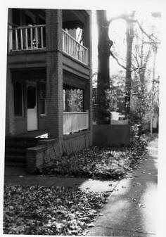
3. Representative photographs of the property: This report contains representative photographs of the property.
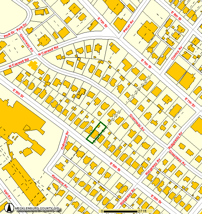
4. Maps depicting the location of the property: This report contains maps which depict the location of the property.
5. Current deed book references to the properties: There is no tax parcel number for the Trolley Walk, which is owned by all adjacent property owners. Tax Parcel Number 127-047-16 is listed in Mecklenburg County Deed Book 6819 at page 151. Tax Parcel Number 127-047-17 is listed in Mecklenburg County Deed Book 4022 at page 520. Tax Parcel Number 127-047-31 is listed in Mecklenburg County Deed Book 5608 at page 368. Tax Parcel Number 127-04730 is listed in Mecklenburg County Deed Book 7221 at page 345. Tax Parcel Number 127-046-15 is listed in Mecklenburg County Deed Book 4030 at page 148. Tax Parcel Number 127-046-16 is listed in Mecklenburg County Deed Book 3115 at page 459. Tax Parcel Number 127-046-26 is listed in Mecklenburg County Deed Book 4365 at page 489. Tax Parcel Number 127-046-25 is listed in Mecklenburg County Deed Book 4593 at page 689.
6. A brief historical sketch of the property: This report contains a brief historical sketch of the property prepared by Frances P. Alexander.
7. A brief architectural description of the property: This report contains brief architectural description of the property prepared by Frances P. Alexander.
8. Documentation of why and in what ways the properties meet criteria for designation set forth in N.C.G.S. 160A-400.5:
a. Special significance in terms of history, architecture, and cultural importance: The Commission judges that the property known as the Trolley Walk property does possess special significance in terms of Charlotte and Mecklenburg County. The Commission bases its judgement on the following considerations: 1) the Trolley Walk was designed ca. 1913 and is one of the original features of the Rosemont subdivision of Elizabeth; 2) the Trolley Walk is one of the few remnants of the streetcar system which spurred suburban development in Charlotte during the early twentieth century; and 3) the walk, with the surrounding early twentieth century housing, clearly illustrate such residential development in the early streetcar suburbs.
b. Integrity of design, setting, workmanship, materials, feeling, and association: The Commission contends that the architectural description by Frances P. Alexander included in this report demonstrates that the Trolley Walk property meet this criterion.
9. Ad Valorem Tax Appraisal: The Commission is aware that designation would allow the owners to apply for an automatic deferral of 50% of the Ad Valorem taxes on all or any portion of the properties which become designated historic landmarks. The current appraised value of the improvements to the Trolley Walk and adjacent properties is $471,410.00. The current appraised value of the Trolley Walk and adjacent properties, Tax Parcel Numbers 127-04716; 127-047-17; 127-047-31; 127-047-30; 127-04-15; 127-046-16; 127-04-26; and 127-046-25, is $626,280.00. The total appraised value of the Trolley Walk and adjacent properties is $1,097,690.00. Tax Parcel Numbers 127-047-16; 127-04717; 127-047-31; 127-047-30; 127-046-15; 127-046-16 are zoned R5. Tax Parcel Numbers 127-046-26 and 127-046-25 are zoned 02.
Date of Preparation of this Report: January 10, 1993
Prepared by: Frances P. Alexander, M.A.
Charlotte-Mecklenburg Historic Landmarks Commission
P.O. Box 35434
Charlotte, North Carolina 28235
(704) 376-9115
Architectural Description
Location and Site Description
The Trolley Walk is located in the Elizabeth neighborhood, an early twentieth century streetcar suburb, of Charlotte, North Carolina. Specifically, the Trolley Walk extends from the west side of East Seventh Street, at the point where Clarice Avenue and East Seventh Street meet, through the middle of the block to Greenway Avenue. From the west side of Greenway Avenue, the walk runs to the east side of East Fifth Street where the path terminates. Along its course, the trolley walk is bounded by early twentieth century residential development, including apartment houses, two-unit dwellings, and single family houses. The proposed designation includes the walkway between East Fifth Street and East Seventh Street.
Architectural Description
The Trolley Walk is a sidewalk, constructed of concrete slabs, which is wide enough to accommodate two lanes of pedestrian traffic. Extending through the center of two city blocks, the walkway is on grade for most of its route, connecting with the public sidewalks along East Seventh Street and Greenway Avenue. However, the walkway ends at concrete steps which lead down to the public sidewalk at East Fifth Street. The Trolley Walk is bordered by residential properties. Two adjoining properties, an apartment house on Seventh Street and a two-unit house on Greenway Avenue, have walkways which connect with the Trolley Walk. In other sections of its path, the Trolley Walk is hedge-lined.
Historical Overview
The Trolley Walk was constructed in the Elizabeth neighborhood, an early streetcar suburb in Charlotte. Elizabeth was developed quickly, but incrementally, in five stages. The first development in Elizabeth was Highland Park, begun in 1891 by the realty company associated with the Highland Mills. Highland Park was located along Elizabeth Avenue, the eastern extension of East Trade Street, near the present location of Central Piedmont Community College. In 1897, the Highland Park Land Company, under the direction of Walter S. Alexander, donated land for a Lutheran College, named Elizabeth College, and the surrounding area soon became known as Elizabeth Hill. At the same time, Elizabeth Avenue was platted as a boulevard, and five years later, in 1903, the East Trade Street electric streetcar line was extended to the college. Begun in 1887, horsedrawn and muledrawn streetcar service in Charlotte already included an established route to what was then the future location of Elizabeth College from West Trade Street at the Richmond and Danville Railway, later the Southern Railway, crossing. The electric trolley network, which began service in March 1891, was expanded over the next 25 years, and by 1903 reached Elizabeth College (Blythe and Brockmann 1961: 264). With the extension of streetcar lines along Elizabeth Avenue, Hawthorne Lane, and Seventh Street, residential subdivision activity quickly followed as reliable and frequent streetcar service provided easy access to the commercial and business centers downtown. By 1907, the boundaries of the city were expanded to include the early rings of suburban development found in Highland Park to the southeast and Dilworth to the south (Hanchett 1984: 7).
In 1900, Piedmont Park, between Central Avenue and Seventh Street, was platted as the second subdivision within the Elizabeth neighborhood. By 1903, Oakhurst, which straddled the main line of the Southern Railroad in the vicinity of the Plaza, Hawthorne Lane, and Central Avenue, was developed to encompass both factory sites as well as residential properties. With trolley service from downtown along Central Avenue and the northern section of Hawthorne Lane through Villa Heights, Central Avenue quickly became a fashionable address. The fourth subdivision within Elizabeth, Elizabeth Heights, was centered around Independence Park, which was built beginning in 1904 as the first municipal public park. Construction in Elizabeth Heights began in 1904 and also included the area between Seventh Street and the present Seaboard Railroad, which had streetcar access along Seventh Street.
The Trolley Walk was built in the Rosemont subdivision, the final phase of construction in Elizabeth and the area farthest from the downtown business district. Rosemont was platted on the former Henry C. Dotger farm which extended roughly from Caswell Road to Briar Creek. Development plans were begun in 1913 for what was initially called Dotger Estates, or alternately, the Pines (Hanchett 1984: 20). The Trolley Walk appears to have been a unique feature of the initial plan (ca. 1913), and the developer intended the Trolley Walk to be a publicly owned right-of-way. However, the city never accepted ownership, and the walk is now owned by adjacent property owners (Pressley 1993). In 1915, Dotger sold his farmland to the newly formed Rosemont Company, comprised of George Watts and Gilbert White of Durham and C.B. Bryant, W.S. Lee, Z.V. Taylor, E.C. Marshall, and Cameron Morrison of Charlotte. The following year, the company hired noted planner, John Nolen of Boston, to design Rosemont. However, little of Nolen’s plan for the new subdivision was implemented. In 1918, Gilbert White had sold his portion of the company to Charlotte real estate agent, E.C. Griffith, who also developed Wesley Heights, the west side residential neighborhood, the West Morehead Street industrial district, and Eastover, an affluent suburb on the east side of Charlotte (Blythe and Brockmann 1961: 173). Griffith was largely responsible for the abandonment of Nolen’s plan, evidently for economic reasons. The curvilinear streets proposed by Nolen created oddly configured lots and increased the costs of surveying (Hanchett 1984: 21). As a result, most of the streets of Rosemont were platted in a conventional grid pattern although East Fifth Street followed a curve so as to meet East Seventh Street, one feature of Nolen’s design.
As the name suggests, streetcar suburban development was, in large measure, determined by the routes of the street rail systems (Warner 1978: 46-65). These transportation networks allowed residential development beyond the historical confines of city cores. Prior to the initiation of rapid and frequent street rail service, development had been limited by the distances people could walk from home to places of businesses and commercial activity. Streetcar service created development opportunities, and as Elizabeth illustrates, residential construction for both the wealthy and the middle class usually followed the extension of routes rather quickly.
The geography of streetcar suburbs generally followed similar patterns. In contrast to the automobile-oriented suburbs of the post-World War II era, the streets along which the trolleys ran were often laid out as grand avenues or boulevards and became prime residential locations for the wealthy. During the early years of the twentieth century, this pattern held true in Elizabeth, and many of the elite of Charlotte built impressive houses along Elizabeth Avenue in Highland Park, Hawthorne Lane in Elizabeth Heights, Central Avenue in Piedmont Park. Now associated with heavy traffic and noise, the wide streets served by the trolleys were desirable precisely because of their proximity to the street rail lines. As grand houses were built on the streetcar boulevards, the side streets, farther from trolley paths, were developed for the middle class. Property values and development potential were inextricably tied to the location of this fixed system of trolleys, and areas, located several blocks from the streetcar line, would command lower prices than properties situated directly on the trolley route. Thus, development patterns in streetcar suburbs were less economically segregated than later automobile suburbs, with housing for the middle class, the wealthy, and sometimes the working class, often found within one suburb although development and property values were determined by proximity to the streetcar route (Warner 1978: 65).
The construction of a walkway, such as the Trolley Walk, at the terminus of the streetcar line was designed to make side street property more valuable than it ordinarily would have been. By designing a public pathway, the developers sought to make Fifth Street lots almost as desirable as Seventh Street, along which the trolleys ran. Indeed, in a 1923 advertising pamphlet for Rosemont, Fifth Street lots sold for $1500.00 while Seventh Street property was valued at $2500.00 per lot, which underscores the role of the streetcar in determining land values (Hanchett 1984: 22). Although the Trolley Walk is not solely responsible, it is clear that the houses found on Fifth Street do not differ substantially from Greenway Avenue and Seventh Street and that Rosemont is more thoroughly middle class than earlier subdivisions of Elizabeth. Developed primarily in the 1920s, Rosemont also reflects the explosion in automobile ownership which occurred after World War 1. Throughout the interwar era, expanding automobile use gradually, but effectively, eliminated dependence on streetcars for inter-city transportation. Consequently, residential development patterns changed with the shift in transportation. Particularly for the affluent, automobiles allowed greater freedom in location. With the weakening of fixed transportation routes, residential development became more segregated by income, and suburbanization became more fluid and far-flung. Nonetheless, streetcar service during the 1920s was still necessary for the working and middle classes and continued to play a role in suburban development. Rosemont, as an area of bungalows, small Tudor Revival cottages, duplexes, and small apartment houses strongly reflected this increasingly homogeneous composition as well as a continued reliance on trolley service.
By the late 1930s, however, streetcar use had declined significantly, and Duke Power Company, which owned the electric street rail system ended operations. By the 1950s, the main boulevards, once some of the most valuable residential real estate in Charlotte, had become undesirable because of noise and congestion. Streetcar routes shifted from residential to commercial use in many cases, and demolition, because of zoning, became commonplace. Indeed, the 1960 master plan for Charlotte slated one-half of Elizabeth for razing (Hanchett 1984: 29). In Elizabeth, the changes in transportation and land use patterns has greatly altered the characteristic streetcar suburban patterns, particularly as institutions, such as hospitals and Central Piedmont Community College, now occupy vast areas of the neighborhood. Consequently, elements such as the Trolley Walk remain as one of the few vestiges of the streetcar system that defined the nature of early twentieth century suburban development.
Conclusion
The Trolley Walk specifically illustrates the importance of the streetcars in determining residential development patterns in the early twentieth century. By constructing this walkway from the terminus of the Elizabeth Avenue-Hawthorne Lane-Seventh Street streetcar line at Clarice Avenue, all the lots in the new subdivision of Rosemont were sited within a two block walk of the streetcar. The Trolley Walk thus created higher values for properties not located directly on the streetcar route. In an area which has undergone tremendous alteration, the Trolley Walk, and the early twentieth properties surrounding the pathway, are remarkably intact and vividly illustrate early twentieth century, middle class, suburban construction.
Bibliography
Bishir, Catherine. North Carolina Architecture. Chapel Hill: University, of North Carolina Press, 1990.
Blythe, LeGette and Charles Raven Brockmann. Hornets’ Nest: The Story of Charlotte and Mecklenburg County. Charlotte: McNally of Charlotte, 1961.
Hanchett, Thomas W. Charlotte Neighborhood Surveys: An Architectural Inventory. Volume III: Cherry, Elizabeth, Crescent Heights, and Plaza Midwood. Charlotte-Mecklenburg Historic Properties Commission, November 1984.
Pressley, R.N., Jr., P.E., Director, Charlotte Department of Transportation. Letter to Frances P. Alexander, Charlotte-Mecklenburg Historic Landmarks Commission, March 11, 1993.
Sanborn Fire Insurance Company. Sanborn Fire Insurance Maps, 1929, and 1953.
Warner, Sam Bass, Jr. Streetcar Suburbs. Cambridge: Harvard University Press, 1978.