Charlotte-Mecklenburg Historic Landmarks Commission

Survey & Research Reports

McLaughlin-Bost House


  1. Name and location of the property: The property known as the McLaughlin-Bost House, located at 415 West John Street, Matthews, North Carolina.


  1. Name and address of the present owner of the property:


Dixie Land Company LLC

PO Box 761

South Boston, VA 24592


  1. Representative photographs of the property: This report contains representative photographs of the property.


  1. Maps depicting the location of the property: This report contains a map depicting the location of the property.


  1. UTM coordinate: 17 524848E 3886231N


  1. Current deed book and tax parcel information for the property:

The Tax Parcel Number is of the property is 22702604.  Deed book number:  10848-835 (10/22/1999)


  1. A brief historical sketch of the property: This report contains a brief historical sketch of the property.


  1. A brief architectural description of the property: This report contains a brief architectural description of the property.


  1. Documentation of why and in what ways the property meets criteria for designation set forth in N. C. G. S. 160A-400.5:


  1. Special significance in terms of its history, architecture, and/or cultural importance: The Commission judges that the property known as the McLaughlin-Bost House does possess special significance in terms of Charlotte-Mecklenburg. The Commission bases its judgment on the following considerations:


1)      The McLaughlin-Bost House, built ca. 1891, exhibits a high degree of integrity, and is distinctive in design from the other historic home in the Town of Matthews.

2)      Situated on East John Street, the McLaughlin-Bost House is a prominent component of the historic landscape of the Town of Matthews.

3)      The McLaughlin-Bost House was built by Joseph McLaughlin, a prominent Mecklenburg County businessman who was formative in the shaping of Matthews in the late 19th century.


  1. Integrity of design, setting, workmanship, materials, feeling and/or association: The Commission contends that the physical and architectural description which is included in this report demonstrates that the McLaughlin-Bost House meets this criterion.


  1. Ad Valorem tax appraisal: The Commission is aware that designation would allow the owner to apply for an automatic deferral of 50% of the Ad Valorem taxes on all or any portion of the property which becomes a designated “historic landmark.” The current total appraised value of the improvements is $89,800. The current appraised value of the land is $987,700. The current total value is $1,077,500.


  1. Portion of property recommended for designation: The exterior of the house and the property associated with the tax parcel are recommended for historic designation.


Date of preparation of this report: March 2005


Prepared by: Stewart Gray and Dr. Paula M. Stathakis

Historical Overview


McLaughlin-Bost House


The land on which the McLauglin Bost House is located was once part of two parcels acquired by Charles Rhyon McLaughlin from T.A. Squires in the spring of 1891. These parcels, totaling 61 acres were purchased for $1245.00[1] Charles McLaughlin was the son of Joseph McLaughlin, a Charlotte businessman. Joseph McLaughlin was an early investor in Matthews’ newly developing commercial row. In 1880, he and J.T. Barrnett of Matthews became partners in the town’s first General Store, McLaughlin and Barrnett.[2] Joseph McLaughlin built the house for his son, and also built a house of the same plan, the Carpenter House, for one of his daughters. The companion house was located on the current site of Matthews Elementary School and was moved to a site across the street sometime before 1935.[3]


Matthews experienced significant growth in the late nineteenth century, all of it a result of the construction of a segment of the Central Carolina Railroad through the town. Prior to the arrival of the railroad, Matthews was a small crossroads community. The town was originally and informally known as Stumptown, because of the number of tree stumps left from its earliest construction projects. Stumptown acquired a Post Office in 1825 and the town named changed its name to Fullwood after the first postmaster John M. Fullwood. The area was settled by small farmers who raised cotton, corn and subsistence crops. Prior to the arrival of the railroad, Fullwood was also a stagecoach stop between Monroe and Charlotte.[4]


The tenor of the town changed irrevocably in 1874 with the construction of a rail line and a stop for the Central Carolina Railroad, placing Fullwood on the line between Wilmington and Tennessee. Railroad officials decided to rename the stop in honor of Watson Matthews, director of the Central Carolina Railroad. The first train blasted through town on December 15, 1874. By the 1920s, thirteen trains passed through Matthews every day. The water tank for the locomotives was located in an area that came to be known as Tank Town. Now known as Crestdale, the area is historically home to the Matthews’s African American population.[5]


The railroad connected Matthews with the outside world and brought new employment opportunities to local citizens, both black and white. The railroad offered unique prospects to the local African American population who were traditionally relegated to field labor and domestic service. The railroad offered steady employment, cash wages, housing, and later, insurance benefits.[6]


Railroads breathe new life into sleepy crossroads communities, and subsequent to the arrival of the Central Carolina, Matthews developed a with commercial purpose. Farmers had the means to send commodities to market and local entrepreneurs had the means to bring in merchandise and produce from other areas. A small commercial district developed near the railroad tracks by 1880.Within four years of the establishment of McLaughlin and Barrnette six other stores and a druggist joined them on commercial row. The 1889 Charlotte City Directory had an advertisement inviting investors to consider Matthews where land was cheap and prospects just beginning. By 1900, Captain T.J. Renfrow started his general merchandise business and in 1906, he built the town’s cotton gin behind his store. Matthews grew to the extent that it received its town charter in March 1879. The 1880 census shows 91 residents in the new town of Matthews.[7]


Charles Rhyon McLaughlin was a business and civic leader in Matthews. He married Mary Belle Grier, the youngest child of Eli Clinton Grier and Lydia Reid Grier. Eli Clinton Grier was a prominent farmer and entrepreneur in the Providence Township. His substantial property holdings were dedicated largely to the production of cotton. He is credited with the construction of the first spinning mill in Mecklenburg County. This enterprise, begun in 1874, had 350 spindles and operated for eighteen months.[8]


Charles and Mary Belle McLaughlin had three children, Charles Joseph [1891-1946], Mattie Grier [b. 1893], and Edmonia Martin [b. 1900]. Charles Joseph, or “Charlie Joe” as he was known about town, married Valeria Rippey Webster and they had no children. Mattie and Edmonia never married. Edmonia, Miss Monie, worked in the Mecklenburg County Deeds Office under John Renfrow who was the Register of Deeds.[9]


According to lifelong Matthews residents, sisters Margaret and Mary Louise Phillips, Charles McLaughlin’s daughter Mattie claimed she was born in the house. The date of her birth is 1893, and this ties the house, generally assumed to have been built in 1891, more concretely to a date in the early 1890s.[10]


During his lifetime, Charles R. McLaughlin was a prominent Matthews citizen. He was a merchant, the mayor of Matthews, and a tax lister for the Morningstar Township. He also donated land for the original site of the Matthews United Methodist Church, approximately 7/8 of an acre, on the corner of Charles and Ames Streets.[11] He and his wife also sold an acre of land to the Morningstar Township Public School Committee for one dollar.[12]


The McLaughlin family owned the house for a few years. Charles McLaughlin sold the house and 61 acres in 1900 to W.W. Alexander.[13] In 1912 Alexander deeded 27 ½ acres, the tract with the house, to his son-in-law, W.J. Bost. Bost was married to Alexander’s daughter Maggie and in the following year she acquired “the house and lot in Matthews” in his will.[14] The 1900 census describes Bost as a farmer.[15]


The property subsequently occupied by Ernest Harold Bost and his wife Sallie Q. Bost.[16] Harold Bost was employed by Southern Engineering. Sallie Bost, originally from South Carolina, taught second grade at Matthews Elementary School. Even during Harold and Sallie Bost’s tenure in the house, the town maintained a rural character. Like many of their neighbors, the Bosts had a large garden and they kept a cow in the rear yard.[17] Harold and Sallie Bost had no children.  After Harold’s death, Sallie Bost had a lifetime interest in the house.  The property passed from brothers Lloyd and Cliff Bost to Lloyd C. Bost Jr. who is the current owner of the property.[18]


Architectural Description


The ca. 1891 McLaughlin-Bost House faces roughly north and sits approximately 50’ from the busy West John Street, four blocks west of historic center of the town of Matthews.  The one-story house was built upon tall, closely spaced brick piers, and is protected by a low-pitched hipped roof.  The principle section of the house is three bays wide, and two bays deep, and appears to be rigidly symmetrical.  A low-pitched hipped-roof porch, covered with metal roof panels, spans nearly the entire width of the façade.  The porch roof is supported by four substantial chamfered posts, and two chamfered pilasters.  The posts and pilasters are connected by guardrails that feature diagonal pickets.  Dilapidated wooden steps lead up to the porch.  The porch shelters double front doors that are centered between tall window openings containing paired narrow double-hung four-over-four windows.   The front windows feature side-hinged screened shutters.  The most notable architectural feature of the McLaughlin-Bost House is the front doorway, which contains paired panel-doors with round-arched upper panels.  The door panels display notable relief and are framed with deep moulded trim.  The doors are topped with a transom featuring two horizontal oval lights.  The doorway also features double screen doors with sawn-work corner braces.  In contrast to the typical weather-board siding that covers most of the house, the wall sections sheltered by the front porch are clad by tongue-and-grooved boards, moulded with a corrugated pattern.


Detail of Front Porch Side Porch


The McLaughlin-Bost House features a water table topped with a drip-cap, corner boards, and a wide freeze board below a boxed soffit.  The only element that breaks with the strict symmetry of the principal section of the house is the interior corbelled chimney which pierces the roof to the west of the roof’s peak.


East Elevation West Elevation

The side elevations of the principle section of the McLaughlin-Bost House appear to be identical.  The front-most bays of the east and west elevations each feature a small hipped-roof porch sheltering a single door topped with a transom.  The side porches are supported by chamfered posts like those found on the front porch, and feature the same corrugated siding attached to the façade.  Each of the side porches is supported by a pair of brick piers.  No steps lead to the side porches.  The rear bays of the side elevations contain double-hung windows.


A hipped-roof wing, built on tall brick piers, extends from the rear of the principal section of the house.  The rear wing is not centered on the rear elevation of the principal section.  Although it is set back slightly, the narrow rear wing is aligned with the west elevation of the principal section.  The rear wing is two bays deep and features a tall corbelled chimney.  The west elevation of the rear wing features two double-hung windows.


Deterioration appears to be limited to the front porch. Several outbuildings survive on the property.


The house suffers from some obvious wood deterioration that may be limited to the front porch steps and boxing.  Unlike the vast majority of Mecklenburg County’s historic houses that were built on piers, the McLaughlin-Bost House has never been underpinned.  The only major alteration to have affected the house is a block-construction bathroom attached to the rear of the south-east corner of the principal section of the house.  Several early 20th century outbuildings survive, although their original usage is difficult to determine.  A large gabled shed sits to the west of the house.  A gabled building in poor condition sits directly to the rear of the house.

Carpenter House


Grier-Furr House – 500 W. John Street, Matthews Reid House – 134 W. John Street, Matthews

In terms of the built historic environment of the town of Matthews, the McLaughlin-Bost House holds an important position. The massed, square plan of the house is at odds with the more traditional single-pile, or one-room-deep, houses that dominated Mecklenburg County’s landscape until the 1890’s.  The nearby ca. 1880 Grier-Furr House is an example of the single-pile design built in a T-plan, one of the last incarnations of the single-pile design.  In form, the McLaughlin-Bost House is more similar to the one-story, massed-plan Reid House.  But where the Reid house features a prominent corner tower and a wealth of decorative sawn-work details, the McLaughlin-Bost House exhibits distinctive but restrained decoration and symmetrical design.  Built by the same family, the Carpenter House appears to follow the same plan as the McLaughlin-Bost House.  The spacing of the fenestration and the roof design of the two houses are nearly identical.  However, having been moved and featuring a later Craftsman Style front porch, the Carpenter House does not exhibit the same high degree of integrity found in the McLaughlin-Bost House.


[1] Mecklenburg County Courthouse, Deeds 77-298 (March 2, 1891) and 77-286 (February 24, 1891). Deed 77-298 conveyed the land on which the house is located.

[2] Paula Hartill Lester, Discover Matthews. From Cotton to Corporate, (Town of Matthews Tourism Council: Herff Jones Publishers, 1999), p 9.

[3] Interview with Margaret and Mary Louise Phillips, March 4, 2005.

[4] Ibid, pp. 5-7.

[5] Ibid, pp, 7, 55-56.

[6] Survey of African American Billings and Sites in Mecklenburg County, Contextual Essay, Paula Stathakis and Stewart Gray, 2002.

[7] Ibid, pp. 7, 9-13.

[8] Survey and Research Report, The Sidney and Ethel Grier House.

[9] Hood, The Tunis Hood Family, p. 345; Interview with Talita Morgan, Historian for United Methodist Church of Matthews, March 2005.

[10] Interview with Margaret and Mary Louise Phillips; Dellman O. Hood, The Tunis Hood Family: Its Lineage and Traditions [Portland, Oregon: Metropolitan Press, 1960], p.345.

[11] Charlotte Observer, February 11, 1952, p. 8-A, “Charles McLaughlin, Matthews Pioneer Succumbs at 83;” Lester, Discover Matthews, p. 66

[12] Deed 129-306, April 9, 1898. This conveyance was valid as long as the land was used as a site for a public school.

[13] Deed 152-166, November 8, 1900.

[14] Deed 303-76, November 19, 1912; Will Book Q, p. 437. March 17, 1913, Will of W.W. Alexander.

[15] U.S. Census of the Population, 1900.

[16] Ernest Harold Bost was a son of W.J. and Maggie Bost.

[17] Interview, Margaret and Mary Louise Phillips.

[18] Deed 4496-624, December 28, 1981. Deed 10848-835, October 22, 1999 transfers the property into Dixie Land Company, LLC.


McLaughlin House

This report was written on November 20, 1998

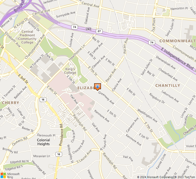
1. Name and location of the property: The property known as the S. Bryce McLaughlin House is located at 2027 Greenway Avenue in Charlotte, North Carolina.

2. Name, address and telephone number of the present owner of the property: The present owners of the property are:

Munro B. & Belva H. Sefcik
2027 Greenway Avenue
Charlotte, NC 28204

3. Representative photographs of the property: This report contains representative black and white photographs of the property. Color slides are available at the Charlotte-Mecklenburg Historic Landmarks Commission office.

4. Maps depicting the location of the property: This report contains three maps depicting the location of the property.

5. Current deed book reference to the property: The most recent deed to this property is recorded in Mecklenburg County Deed Book 7483 on page 827. The tax parcel number of the property is #127-046-09.

6. A brief historical sketch of the property: This report contains a brief historical sketch of the property.

7. A brief architectural description of the property: This report contains a brief architectural background and a physical description of the property.

8. Documentation of why and in what ways the property meets criteria for designation set forth in N. C. G. S. 160A-400.5:


a. Special significance in terms of its history, architecture, and/or cultural importance: The Commission judges that the property known as the S. Bryce McLaughlin House does possess special significance in terms of Charlotte-Mecklenburg. The Commission bases its judgment on the following considerations:

1) The S. Bryce McLaughlin House was built by S. Bryce and Bertha Dotger McLaughlin in 1911 on a portion her family’s land. It is the only remaining historic structure associated with the Dotger farm, which stretched between Caswell Road and Briar Creek.

2) The S. Bryce McLaughlin House predates, and is therefore the earliest house in, the Rosemont section of Charlotte’s historic Elizabeth neighborhood.

3) The S. Bryce McLaughlin House, a one and one-half story shingled bungalow, is a genuine Craftsman House and a good example of the style. It was built from a plan that was published in 1908 in The Craftsman magazine, and is thus the product of the legendary furniture designer and architect Gustav Stickley. There are no other known Stickley designs among the designated Charlotte-Mecklenburg Historic Landmarks.

b. Integrity of design, setting, workmanship, materials, feeling and/or association: The Commission contends that the physical and architectural description which is included in this report demonstrates that the S. Bryce McLaughlin House meets this criteria.

9. Ad Valorem tax appraisal: The Commission is aware that designation would allow the owner to apply for an automatic deferral of 50% of the Ad Valorem taxes on all or any portion of the property which becomes a designated “historic landmark.” The current total appraised value of the improvements is $ 182,200. The current total appraised value of the lot is $ 80,000. The current total value is $ 262,200. The property is zoned R-5.

10. Portion of the property recommended for designation: The interior and exterior of the S. Bryce McLaughlin House and its lot are currently being considered for designation.

Date of preparation of this report: November 20, 1998
Prepared by: Mary Beth Gatza
P. O. Box 5261
Charlotte, NC 28299

(704) 331 9660


Historical Overview
 

Historical Significance

The S. Bryce McLaughlin House was built in 1911 by S. Bryce and Bertha Dotger McLaughlin on a portion of the Dotger farm. At the time, it was sited to face what is now called Caswell Road. During the mid-1910s, the house was picked up and turned around to face Greenway Avenue, which was still undeveloped at the time. It is the earliest house in the Rosemont section of Charlotte’s Elizabeth neighborhood, and is the only remaining residence associated historically with the Dotger farm (which stretched from Caswell Road to Briar Creek).

Land History

At the turn of the twentieth century, the land surrounding downtown Charlotte was overwhelmingly rural. Andrew J. Dotger owned a farm where the Rosemont section of Elizabeth now stands. Andrew Dotger was originally from the Philadelphia, Pennsylvania area, and ultimately returned to the northeast. During his stay in Mecklenburg, however, he purchased three tracts on Monroe Road in the 1890s.1 Together they totaled 89 acres and included an old plantation house on Monroe Road.2 It is unknown whether Andrew Dotger ever resided in the house, but what is known is that by 1899, he had left Charlotte and settled in Essex County in northern New Jersey.3

“Because of my love and affection,” Andrew J. Dotger granted a life estate4 to his brother, Henry C. Dotger (1862-1936), Henry’s wife, Bertha M. Dotger (1861-1932), and their heirs. In the deed, Andrew stated that Henry, Bertha and their survivors “may occupy and use the said plantation as a home” rent free (provided they pay the taxes) “as long as they…may elect to live upon the said place.”5 Andrew’s gift of tenure to his brother was not without conditions. Andrew was specific on a number of points, as follows: 1) The title to the land would transfer to the children of Henry and Bertha Dotger upon their deaths 2) “No partition of said land nor any sale thereof shall be made…until the youngest child shall arrive at the age of twenty-one years…” 3) “Upon my death…the title to the said land shell vest in the executor of my will to be held by him…” In making these stipulations, Andrew effectively prevented Henry from controlling the future disposition of the property.6

By the first decade of the twentieth century, Charlotte’s urban development pressed outward, inching closer and closer to the Dotger Farm. Dilworth, Charlotte’s first suburb, had opened in 1891, and various other neighborhoods around town experienced their genesis within the next two decades. Four of the five developments which make up the neighborhood now called Elizabeth were started in the decade surrounding the turn of the century. They are: Highland Park (Elizabeth Avenue), 1897; Piedmont Park (Sunnyside Avenue, Central Avenue), 1900; Oakhurst (Bay Street, Hawthorne Lane), 1903; and Elizabeth Heights (East Eighth Street, Clement Avenue), 1904.7 The fifth and final section, Rosemont, was yet to be.

In 1907, the boundaries of the burgeoning city of Charlotte were extended in all directions, greatly enlarging the size of the city. To the southeast, the city line now came right up to Henry’s side yard (near present-day Ridgeway Avenue), and included a portion of the Dotger land. Henry, no doubt, was aware of the development opportunities and the potential for profit therein. Due to the terms of the life estate, however, Henry’s ability to sell the land was restricted, forcing him to petition the courts for permission to subdivide. The Mecklenburg Superior Court ruled in January 1912 that the land could indeed be sold. The court order reads, in part, that “the interest of all parties concerned would be materially enhanced if the lands…were sold…”8 Purchase offers were already pending for three tracts in 1912. One offer was from S. Bryce McLaughlin for .45 acres near what was then described as the intersection of East Sixth Street and Old Monroe Road (now Greenway Avenue and Caswell Road).9

The deed to the McLaughlin property was not in fact delivered until 1915. The reason for this delay is unclear. A court document dated October 1915 authorizes again the sale of “the said property to the said Bertha Dotger McLaughlin, wife of S. Bryce McLaughlin…” This document mentions that “the said lot has a residence upon it of the value of about $5000.00 which was erected…by the said S. Bryce McLaughlin at his own cost and expense with the understanding…that a deed to said lot would be made to him or his said wife at a fair price when the same could be done legally…” The deed was finally executed on October 20, 1915, to a home that the McLaughlins had lived in for four years.10

Later sections of this same court document address the lots and houses of two of Bertha’s sisters. Freda L. (Mrs. A. W.) Burch and Anna C. (Mrs. W. C.) Kirby both had homes on East Seventh Street that they desired legal title to. In both sections, the legal language and the description of the house is the same as for the McLaughlin House. In both cases, the court ordered the sales–for the Burch House in 1919 and for the Kirby House in 1920.11 Neither house is still standing.

Rosemont Company

The Rosemont Company incorporated on February 20, 1915. 1,250 shares of stock were authorized, valued at $100 each (total $125,000). There were seven original stockholders, who divided 500 shares unequally among themselves. They were: George W. Watts (200 shares); G. C. White (100 shares); C. B. Bryant (50 shares); Cameron Morrison (50 shares); W. S. Lee (34 shares); Z. V. Taylor (33 shares); and E. C. Marshall (33 shares). The Rosemont Company was empowered to do the following:

1) buy and sell land
2) lay out lots, block and streets
3) own, construct, sell or lease buildings
4) buy and sell their capital stock
5) enter into contracts
6) issue bonds

No doubt the Rosemont Company was created specifically in order to develop the Dotger farm, because they purchased the remainder of the Dotger tract in March of 1915, and made no other major purchases. Since they paid $110,000 for the land, they apparently were able to sell more shares or otherwise raise capital quickly.12

Developing the Dotger tract took the Rosemont Company a good six years. The earliest plat on file in the Mecklenburg County courthouse is dated May 1921.13 By then the development was officially named “Rosemont.” The map is labeled as a revised plat, implying that an earlier plan existed. Research done in the 1980s states that a map was drawn in 1913 and another in 1916. The 1916 plat, which has never been found, was reportedly drawn by noted landscape architect John Nolen,14 who designed Independence Park (1905) on East Seventh Street and was chief planner of the Myers Park neighborhood (1911). Earliest lot sales in Rosemont, as listed in the deed indexes, were in March of 1921.15

Greenway Avenue was created in the 1910s. The first mention of it in the city directories is in 1916, at which time it was named as the address for the S. Bryce McLaughlin House. Although the house had been standing since 1911, it had originally faced Monroe Road (now Caswell Street). It was moved sometime between 1914 and 1916–it was reportedly lifted and rotated on its site to face the new and as-yet-undeveloped Greenway Avenue. No other houses show up in the city directories on Greenway Avenue until 1923/24, at which time seventeen addresses were listed. Thus, the S. Bryce McLaughlin House stood alone facing Greenway between the time it was moved in the mid-1910s and 1923–almost ten years.

Henry Dotger Family

Henry Casper Dotger (1862-1936) was born in Philadelphia, Pennsylvania on September 12, 1862. It was there, presumably, that he met and in 1884 married another Philadelphian, Bertha Marie Shutt (1861-1932). They arrived in Charlotte in the 1890s and by 1899 were settled on the Monroe Road tract of land Dotger’s brother owned. Henry worked the land as a dairy farm and raised his family there. Four of the Dotger’s five children made the move to Charlotte with their parents, the youngest child was born here. The children were: Freda (1885-1973), Anna (1887-1953), Frederick (1888-1969), Bertha (1886-1919) and Dorothy (1901-1989).16 Fred became a dairy farmer in his own right, leaving the family land but remaining in Mecklenburg County. All four daughters attended Elizabeth College in Charlotte. At that time, the college was located at the end of Elizabeth Avenue at Hawthorne Lane (now Presbyterian Hospital), and thus was within walking distance for the girls.17

Freda Dotger (1885-1973) was married twice–first in 1908 to Albert Waterman Burch (1861-1924), and second to Charles R. Nisbet (1871-1943) in 1931. Together A. W. and Freda had two daughters, and built and lived in a house (no longer standing) on East Seventh Street and Caswell Avenue.18

Anna Dotger (1887-1953) was well-educated–she attended Swarthmore College and Columbia University before returning to Charlotte to teach at Elizabeth College. She married William C. Kirby (1872-1967), and they built and resided in a home next to her sister, Freda, on East Seventh Street near Caswell Avenue. This house is no longer standing. Anna and William Kirby had three children, a son and two daughters.19

Dorothy (1901-1989), the youngest daughter, achieved success as a professional golfer. She married Richard Thigpen, and had three children with him.20 Together they resided in the Dotger farmhouse after the death of Henry and Bertha Dotger.

Bertha Dotger (1886-1919) chose for her husband Samuel Bryce McLaughlin (1886-1969). They were wed “on the lovely green in front of her father’s house” on May 24, 1911. The “beautiful setting” was “redolent with the fragrance of honeysuckle and magnolia;” the ceremony itself was “marked with charming simplicity.” At the time, the bride was described as “cultured and charming,” “gifted with beauty of face and grace” and “exceedingly popular.” After the “elegant reception” at her parent’s house, the couple departed for their honeymoon to three northern cities–New York, Philadelphia and Washington, DC.21

In preparation for their life together, Bryce and Bertha built a house in 1911 on her family’s land. Their wedding announcement in the Charlotte News mentioned that after their honeymoon “they will occupy their pretty new bungalow near the Dotger home.”22 Bryce and Bertha built from a plan that had been published in The Craftsman magazine in December 1908. They sited the house facing, yet well back from, what was then called Monroe Road (now Caswell Road). Just a few years later, in the mid-1910s, they turned the house to face what was to become Greenway Avenue.

S. Bryce McLaughlin Family

S. Bryce McLaughlin was the son of Margaret Gillespie and John B. McLaughlin (1855-1937). J. B. McLaughlin served as alderman for the city of Charlotte for fourteen years, and as chairman of the board of county commissioners for four years. Bryce was well-educated–he attended Baird School for Boys, Brown University, Davidson College, and Erskine College. Upon the occasion of his marriage, it was said of Bryce that he was “of Mecklenburg traditions and inherits with them the characteristics of his forebears–high integrity, honor, strong convictions and close adherence to principle.”23 Years later, his daughter would describe him as “a wonderful man,” “stately,” “dignified,” and very “knowledgeable.” She remembers him as “loving” and extremely kind to others.24

As a young man, Bryce McLaughlin worked in his father’s store, Cochrane & McLaughlin Company, on College Street. Bryce was listed in the city directories at various times as salesman, bookkeeper or manager. At some point, he shifted careers and went into real estate loans and insurance. He is known to have worked for the Federal Land Bank (Columbia, SC) from 1917-1919, and for the State and City Bank and Trust Company (Richmond, VA) from 1922-1924.25 Although it involved much travel away from his family, McLaughlin stayed in this line of work for many years. He employed a housekeeper who lived in the house and helped look after the children.26 Bryce McLaughlin died at home in 1969 at the age of 83.

Bryce and Bertha McLaughlin had three children: S. Bryce, Jr. (1914-1921), Harry (1916-1989) and Bertha (b. 1919). Bryce died at age seven of spinal meningitis. Harry graduated from Davidson College in 1938, fought in World War II, worked for the post office, and served as a church elder. He lived in Waxhaw at the time of his death in 1989.27 Daughter Bertha eventually married and moved away. Young Bertha never knew her mother, because, tragically, Bertha, Sr. died only hours after giving birth to her only daughter.

Bertha’s death on February 12, 1919, at age 28, was sudden and unexplained. The newspaper reported that it “was a shock to scores of friends.” She was described as “delightful in personality and possessing of the love and esteem of many friends.” Her obituary further noted that “she loved the home life and was a devoted mother.”28

Bryce McLaughlin mourned the loss of both his eldest son and his wife. Eventually, though, he got remarried to Miss Anne Graham Kyle (1895-1973). They were wed on April 15, 1927 at her father’s home near Lynchburg, Virginia. She reportedly hailed “from families widely known in this section of Virginia” and was a graduate of Agnes Scott College in Decatur, Georgia.29

After graduating from college in 1917, Anne relocated to Richmond, Virginia, where she worked for the YWCA in 1917 and 1918. She then moved to Charlotte, where she remained in the employ of the YWCA from 1918-1921. She was active in the Daughters of the American Revolution both here and in Virginia. She died on May 6, 1973.30

After the death of Anne McLaughlin, the S. Bryce McLaughlin House passed to Bryce’s surviving children, Harry and Bertha, who sold the property in 1973. It passed through a succession of owners between 1973 and 1993 when it was purchased by the current owners.


Architectural Description
 

Gustav Stickley

Gustav Stickley (1858-1942) was one of eleven children born on a farm in Wisconsin to Leopold and Barbara Stoeckel. The family moved to Pennsylvania in 1874 or 1875, and there Gustav began the first phase of his career–making furniture. For the next decade and a half, Stickley produced and sold wooden furniture, working at times with various partners, including an uncle and a brother.31 From these inauspicious beginnings, Stickley would parlay his interest and experience in furniture design into an historic empire. Within two short decades, the name Gustav Stickley would become synonymous with the Craftsman Movement, which had a major impact on early-twentieth century furniture, decorative arts, textile design and architecture.

Arts & Crafts Movement

By the end of the century, Stickley had developed an active interest in the Arts & Crafts Movement, which had enjoyed a steady following in England since the 1860s. Proponents of the Arts & Crafts Movement argued for a departure from the fussy, mass-produced, and often poor-quality objects that were abundant during the Victorian era. They desired, instead, a more prideful, professional approach to the decorative arts, such as was found in the medieval crafts guilds.

After a trip to Great Britain in 1898, Stickley expressed the design ideals and philosophy of the Arts & Crafts Movement through his furniture. He abandoned the standard ornate Victorian motifs and constructed furniture that was simple, robust and straightforward. His designs were unique and represented a complete departure from all that was popular at the time. “Craftsman” was the name he gave to his style, though it is sometimes generically referred to as mission furniture. Stickley stamped or labeled each piece with his own maker’s mark–a drawing of a medieval joiner’s compass and the motto “Als ik kan” (as I can).

The Craftsman

In 1901, Stickley created a magazine with a dual purpose–to preach the Arts & Crafts philosophies and to market his own furniture. The premier issue of The Craftsman appeared on October 1, 1901. The magazine was widely distributed and proved to be immensely popular. During its fifteen-year run, The Crafstman magazine featured articles on many diverse topics, but always retained its focus on Arts & Crafts ideals. The magazine was so influential that eventually the Arts & Crafts Movement came to be called the Craftsman Movement.

It was only natural that Stickley’s interest in home furnishings would expand to include architectural design. In August of 1902, the first house plan appeared in the pages of The Craftsman magazine. In mid-1903, he hired two professional architects, Ernest G. W. Dietrich (1857-1924) and Harvey Ellis (1852-1904), and published plans in the magazine for the first of many “Craftsman Houses.” In November of 1903, The Craftsman readers saw the introduction of the Homebuilder’s Club. In this program, subscribers could order any published house plan free of charge. The Homebuilder’s Club was so successful that it remained active for the remainder of the magazine’s run. Stickley boasted in 1915 that over $20 million dollars worth of Craftsman homes had been built that year across the United States and in such far-flung places as Fiji.32

Craftsman Houses

At the turn of the century, a brand-new house type, called a bungalow, was on the horizon. The bungalow represented a radical change from Victorian architecture not just stylistically, but also functionally. It was anticipated that the modern twentieth-century family would not rely as heavily on domestic servants, and would lead a less formal lifestyle than their parents did. Voices of progressive reformers, feminists and home economists were all calling for a new, modern, efficient home environment. Bungalows were thus streamlined and designed to make housework simpler and easier. This was achieved, in part, by building smaller houses with fewer, larger rooms and by opening up floor plans. Architects strove to minimize clutter and dust-catching surfaces. They dispensed with elaborate moldings and woodwork, and reduced the need for free-standing furniture by incorporating built-ins (bookcases, cabinets, seating, dressers, etc.). This new approach to domestic architecture fit nicely with the Arts & Crafts ethic, and Stickley quickly gravitated toward it.

The bungalow aesthetic included simple lines, low-pitched gable roofs, engaged porches (where the porch is sheltered by the main roof, with no change in pitch), dormers and grouped windows. Honest, natural materials were favored, especially wood, brick and uncut stone. Architects were not afraid to show construction details, like exposed roof rafter ends on the outside and boxed ceiling beans on the inside. Design lines were kept simple–straight lines and clean surfaces.

Stickley’s Craftsman houses, like his furniture, focused on strength and simplicity. He made full use of the bungalow vocabulary, and yet created plans with his own unique style. Believing that the hearth was the center of the home, Stickley’s plans featured predominant fireplaces, and he included fireside inglenooks wherever possible. Stickley’s hallmark was interior woodwork, virtually always stained in a dark finish. His designs included liberal use of door and window trim, hardwood floors, wainscoting, ceiling beams, staircases, and built-in furniture. He always drew clean, simple lines. The overall effect was richness without fussiness.

Stickley’s mating of the Arts & Crafts idiom with the bungalow house type was a success. He was not the first or only architect using the bungalow house type or the Arts & Crafts style. Stickley was, however, the most influential, since it was he who disseminated the Craftsman House across America. Through The Craftsman magazine, he brought his unique style to the forefront by giving it wide distribution. Never before had an architectural style been popularized in such a manner.


PHYSICAL DESCRIPTION

Architectural Significance

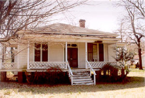
The S. Bryce McLaughlin House has architectural significance as a good example of a genuine Craftsman House with exceptional integrity. The one and one-half story wood-shingled bungalow was built in 1911 following plans printed three years earlier in The Craftsman magazine. The plan was published by Gustav Stickley, whose influential magazine, The Craftsman, popularized his unique Craftsman House style and ultimately spawned an empire revolving around Stickley’s own designs in architecture, furniture and decorative arts.

S. Bryce McLaughlin House

S. Bryce McLaughlin based his modern new home on a plan that first appeared in The Craftsman magazine in December of 1908. It was described there as “a roomy, inviting farmhouse, designed for pleasant home life in the country.”33 Some minor modifications were made to the plan–namely McLaughlin’s choice to eliminate a fourth bedroom upstairs and to use the big room on the first floor (originally planned as a kitchen) for living space and build a smaller kitchen next to it, in an area that had been planned as an outside kitchen. He also opted to reverse the plan, flopping it so the entry would be on the right instead of the left. Otherwise, the S. Bryce McLaughlin House is identical to the published plan.

The house is a one and one-half story bungalow with a low-pitched, side-gabled roof. A full-width front porch shields the entire facade, and is composed of a broad shed roof supported by tapered, square wood columns. Windows throughout the house are four-over-one double-hung sash, placed in groups. The facade wears two sets of two windows and a group of three windows. A very broad shed dormer pierces the roofline and holds similar grouped windows–two sets of two and a group of three. Exposed roof rafter ends delineate the eave line all around the house. The entry is located in the right (east) bay of the facade and features a wide, glazed front door. The exterior of the house is clad with wood shingles. There is a wide, brick exterior end chimney with gently sloping shoulders on the east side elevation.

The only modification to the exterior of the house in its eighty-seven year history is the enclosing of a screened porch on the left rear (northwest) corner. This was accomplished by using wood-shingled walls and one-over-one double-hung sash windows of a similar size and shape to the original. As a result, the alteration blends almost seamlessly with the original fabric.

On the interior, Stickley’s trademark emphasis on dark-stained woodwork is apparent. Every surface in the living room is trimmed in dark woodwork–the floors are hardwood, the ceiling in beamed, the walls are sheathed with board-and-batten wainscot. The same dark trim surrounds the doors and windows, including the panelled pocket doors to the dining room.


Dining Room

Built-In Window Seat

The central focus, of the room, however, is the fireplace inglenook at the left (east) end of the room. Here Stickley placed a brick fireplace in an alcove and surrounded it with built-in benches, creating a cozy, intimate space. Stickley favored enclosed stairways in his Craftsman Houses, and that inclination is seen here. The stair begins in the living room, takes a quarter-turn and rises up through the wall cavity to the second floor. There is no newel post or balustrade, but instead the stringer (the side piece of the staircase) extends upward high enough to function as a railing.

The second floor holds three rooms and a bath. Originally, there were three bedrooms, but the wall between the center room and the hallway was removed by previous owners. It is still a distinct room, but is now open to the stairway. The characteristic dark wood found downstairs is also repeated on the second floor in the panelled doors and trim. In the bathroom, the original clawfoot tub is still in place.

A few alterations have taken place on the interior since the house was built in 1911. They include: the addition of a few closets and a second bathroom; the removal of a wall on the second floor; and a kitchen remodeling. Virtually no original material has been removed.

A two-car garage stands to the rear of the lot (northwest corner). It is a rectangular frame building with a front-gabled roof and is covered with German siding. It is not thought to have been built at the same time as the house (1911), since it is positioned relative to the current, and not the original, siting. It is, however, thought to date from the repositioning of the house in the mid-1910s, and should therefore be considered contemporary with the house.


Notes

1 Mecklenburg County Deed Book 104, page 122; Mecklenburg County Deed Book 110, page 306; Mecklenburg County Deed Book 134, page 497.

2 In current terms, the Dotger house was located on East Seventh Street between Ridgeway and Laurel Avenues. Demolished in the 1960s, it is now the site of the Carolina Eye Associates building.

3 Mecklenburg County Deed Book 134, page 497.

4 A life estate is an arrangement where the first party gives the second party the legal right to occupy the property for the remainder of the second party’s life, without actually transferring legal ownership to the second party.

5 Mecklenburg County Deed Book 134, page 497; Mecklenburg Superior Court Civil Minute Book 18, page 175.

6 Mecklenburg Superior Court Minute Book 18, page 175; Mecklenburg County Deed Book 134, page 497.

7 Thomas W. Hanchett, “Charlotte and Its Neighborhoods: The Growth of a New South City, 1850-1930” (draft manuscript for the Charlotte-Mecklenburg Historic Properties Commission, 1985), pp. 5-11.

8 Mecklenburg Superior Court Minute Book 18, pages 174-78.

9 One offer was from the Sisters of Mercy for five and one-third acres (most likely the site of the present-day Mercy Hospital), and another was from a W. L. Nicholson for 1.87 acres on East Seventh Street.

10 Mecklenburg Superior Court Minute Book 24, page 75; Mecklenburg County Deed Book 351, page 188.

11 Mecklenburg Superior Court Minute Book 24, pages 75-77.

12 Mecklenburg County Records of Corporation, Book 4, pages 270-71; Mecklenburg County Deed Book 337, page 455.

13 Mecklenburg County Map Book 322, page 230.

14 Hanchett, “Charlotte and Its Neighborhoods” (draft), pp. 20-21.; Black & Black, “Elizabeth Historic District National Register Nomination,” p. 8.7.

15 Mecklenburg County Grantor Index, 1919-1936.

16 The Charlotte News, 11 October 1936, p. 1B; The Charlotte Observer, 11 October 1936, p. 1; The Charlotte Observer, 10 September 1932, p. 7; The Charlotte News, 1 January 1970, p. 4A.

17 Interview with Bertha McLaughlin Johnson, 25 October 1998.

18 The Charlotte Observer, 5 November 1924, p. 1; The Charlotte Observer, 6 June 1943, sec. 2, p. 1.

19 The Charlotte News, 19 October 1967, p. 8A.

20 The Charlotte Observer, 5 October 1989, p. 9B.

21 The Charlotte News, 25 May 1911, p. 2.

22 The Charlotte News, 25 May 1911, p. 2.

23 The Charlotte News, 25 May 1911, p. 2, The Charlotte News, 6 September 1969, p. 3A.

24 Interview with Bertha McLaughlin (Mrs. Grant) Johnson, 25 October 1998.

25 Charlotte City Directories, various years; The Charlotte News, 6 September 1969, p. 3A.

26 Johnson interview, 25 October 1998.

27 The Charlotte Observer, 3 June 1989, p. 12A.

28 The Charlotte Observer, 13 February 1919, p. 5.

29 The Charlotte Observer, 17 April 1927, sec. 2, p. 3.

30 The Charlotte Observer, 9 May 1973, p. 18B.

31 Barry Sanders, A Complex Fate: Gustav Stickley and the Craftsman Movement (New York: John Wiley & Sons, Inc., 1996), pp. 4-9; Mary Ann Smith, Gustav Stickley, The Craftsman (New York: Syracuse University Press, 1983), pp. 1-7; Jeff Wilkinson, “Who They Were: Gustav Stickley.” Old-House Journal Vol. XIX No. 4. (July/August 1991), pp. 22, 24.

32 Sanders, Complex Fate, pp. 85-88; Smith, The Craftsman, pp. 45, 54-57, 77.

33 Gustav Stickley, Craftsman Homes (NY: Craftsman Publishing Co., 1909; reprint ed., NY: Dover Publications, Inc., 1979) pp. 52-3.


McIntyre Site

I. Statement of Purpose: It is the purpose of this report to set forth the reasons why the McIntyre Site Committee of the Charlotte-Mecklenburg Historic Properties Commission believes that the McIntyre Site, located to the northwest of Charlotte , NC, at the intersection of Beatties Ford Road and McIntyre Avenue, is worthy to be listed in the National Register of Historic Places. First, the report will describe the historic significance of the site. Second, it will explain the committee’s understanding of the National Register of Historic Places. Third, it will measure the site against the criteria of the National Register of Historic Places. Hopefully, this report will persuade the State Historic Preservation Officer to nominate the McIntyre Site for listing in the National Register of Historic Places.

II. Historic Significance of the McIntyre Site:

The historic significance of the McIntyre Site to Charlotte and Mecklenburg County has long been recognized. Indeed, The Charlotte Daily Observer of February 22, 1908, included it in a list of historic places. Further documenting the longevity of its recognition is the fact that two markers were erected on the site in the first decade of this century. The justification most commonly used for singling out the McIntyre Site is its association with the Revolutionary War skirmish, locally known as the “Battle of the Hornets’ Nest” or “Battle of the Bees.” On October 3, 1780 (according to some sources the skirmish occurred on October 5, 1780), elements of Lord Cornwallis’s army, having occupied Charlotte on September 26, encountered a small detachment of American militiamen on and in the vicinity of the McIntyre Site. Although not a major engagement, the skirmish between some 14 Scotch-Irish settlers and approximately 300 foraging Red Coats takes on wider significance in light of assessments advanced by Samuel Eliot Morison in his widely-acclaimed The Oxford History of the American People. Professor Morison contends that the ultimate defeat of Lord Cornwallis at Yorktown and, therefore, the victory of the United States of America in the Revolutionary War were the result of “two unexpected factors.” “The Carolina Loyalists,” he writes, “were neither numerous nor strong enough to counteract the local Patriots, and the French navy intervened at a crucial point.” Clearly, the McIntyre Site, the only relatively undisturbed battleground of the Revolutionary Era in Charlotte and Mecklenburg County, possesses local historic significance.

McIntyre Site also contains the foundation of the log house which John McIntyre built soon after he purchased the property in 1769. Unfortunately, the house was destroyed in the early 1940’s. However, Mr. Stuart Schwartz, who has had academic training in historic archeology, asserts that the site promises to yield significant archeological data. Also noteworthy is the fact the McIntyre Cabin was recorded by the Historic American Building Survey in the 1930’s, thereby providing measured drawings which allow an authentic reconstruction to occur as soon as funds are available. That the McIntyre Cabin was regarded as an architecturally significant is certain. For example, it received substantial attention in the widely acclaimed book co-authored by F. B. Johnson and T. T. Waterman, The Early Architecture of North Carolina. On balance, the evidence suggests that the McIntyre Site possesses local historic significance, both because it promises to yield significant archeological data from an 18th century Mecklenburg farm and because it contains the foundation of an architecturally important structure which could be easily reconstructed.

In the second quarter of the nineteenth century the McIntyre Site served as the location of the Hipp Gold Mine. The first record of gold in the area was the discovery of a large nugget in 1790 in what is now Cabarrus County. Conrad Reed’s young son, while fishing, saw it shining in a creek on his father’s farm and took it home. Not knowing what it was, the family used it as a doorstop for several years. In 1825 Samuel McComb made the first successful attempt to follow a vein of gold, located on his farm just to the south of Charlotte. Soon thereafter prospectors poured into the Piedmont, thereby creating the first gold rush in the United States. Small mines, consisting of surface trenches on hillsides above streams, dotted the landscape. Stuart Schwartz has confirmed that the McIntyre Site contains many of the trenches of the Hipp Gold Mine. Consequently, it is reasonable to assume that archeological data associated with nineteenth-century gold mining operations is present on the property. This information underscores the local historic significance of the McIntyre Site.

That the people of Charlotte and Mecklenburg County consider the McIntyre Site to be historically significant is certain. Attached are several newspaper articles and other printed materials which document this fact. Perhaps the most convincing evidence, however, was provided by the development of the McIntyre Historic Site as a Bicentennial Project. Funding for this undertaking was secured from several sources: Charlotte-Mecklenburg Bicentennial Commission, Charlotte-Mecklenburg Historic Properties Commission, Mecklenburg County, Junior Woman’s Club of Charlotte, and the North Carolina American Revolution Bicentennial Committee. The official opening of the park on October 5, 1976 (see attached program), was an official Bicentennial Activity (#021438) and was recorded on the Bicentennial Information Network — BINET.

The McIntyre Historic Site is an educational complex which consists of a pathway, along which one encounters signs that interpret the history of the site and of the larger context within which the site has evolved (see photographs 1, 2, 3, and 4). The initial theme centers around the Revolutionary skirmish and its place within Cornwallis’s Southern Campaign. Highlights include the remains of the cabin (photograph 5), an explanation of the skirmish (photograph 6), and a description of Cornwallis’s Campaign from Charleston to Yorktown (photographs 7 and 8). The visitor then encounters a series of signs which interpret gold mining in the Piedmont (photographs 9 and 10). Adding to the effectiveness of the signs is the fact that they are placed beside and among the mining trenches (photographs 11 and 12).

III. Committee’s Understanding of the National Register of Historic Places: The committee understands that the National Register of Historic Places, created by the National Historic Preservation Act of 1966, represents an expansion of the Federal government’s concern for properties of historic significance to include those of State, regional, and local significance. Furthermore, the Committee views the National Register as a planning device, whereby the Federal government takes into account the impact of Federally licensed and Federally funded programs upon properties of State, regional, and local historic significance. Finally, the Committee believes that the National Register is not intended to be exclusively a list of buildings or structures.

IV. Measurement of the McIntyre Site against the Criteria of the National Register of Historic Places: The Committee believes that the evidence presented in Section II of this report demonstrates that the McIntyre Site is historically significant to Charlotte and Mecklenburg County. Consequently, the Committee believes that the McIntyre Site qualifies for listing in the National Register of Historic Places.


Historical Overview
 

For a full understanding of the skirmish at McIntyre’s Farm some contextual information might be useful. On August 16, 1780 the British army commanded by Lord Charles Cornwallis routed an American Army under the command of Horatio Gates at the Battle of Camden in South Carolina. For all practical purposes the American Army ceased to exist in the South. Gates retired to Hillsborough, North Carolina, where he began the arduous task of rebuilding. This left Cornwallis in nominal control of South Carolina. To the considerable surprise of Cornwallis, that control was contested by bands of partisan irregulars, including those commanded by the famous South Carolina triumvirate of Francis Marion, Thomas Sumter, and Andrew Pickens. Although not strong enough to take on the main British army, these irregulars interrupted communications, ambushed supply trains, picked off stranglers, and harassed Loyalists. Patriots in North Carolina were likewise mobilized into action. On September 8 a group under the command of William R. Davie, later governor of North Carolina, surprised the British at Wahab’s Plantation, just south of the border, in a hit and run raid that resulted in numerous British Casualties.

Despite this constant harassment Cornwallis decided to move into North Carolina. His first stop would be Charlotte, then a small community which was attractive to the British primarily because of its relatively large number of mills. From Charlotte he would go to Salisbury, Salem, and Guilford Courthouse, before finishing at Hillsborough, which he had been led to believe was a hotbed of Loyalism. His advance through the state would embolden North Carolina Loyalists, who would fly to the King’s standard. Not only would this campaign secure North Carolina, but it would also overawe the by now isolated South Carolina rebels, ending resistance in that state. Cornwallis would then advance into Virginia and win the war for the King. For this plan to work it was essential for Cornwallis to keep his west flank secure, for he feared the hostile mountain and transmontane men of the west. To that end he sent a large force of Loyalist militia under the command of Patrick Ferguson to the foothills of the Carolina mountains. Ferguson’s job was to protect Cornwallis’ left flank and raise Loyalist militia. He was not to seek a general engagement.

Cornwallis moved into Charlotte on September 26 (some accounts say the 27th, even the 28th). A militia contingent under the command of Davie fought a vigorous rearguard action in the streets of the village before being forced to retire. Although Cornwallis knew the area was not completely loyal he had every expectation that his presence would intimidate opponents while attracting supporters. He overestimated both Loyalist numbers and initiative, a common British mistake during the war. We have plenty of contemporary evidence that the British found Charlotte most inhospitable. On October 3 Cornwallis wrote a correspondent that “Charlotte is an agreeable village but in a damned rebellious country.” His subordinate, the controversial Banastre (Bloody) Tarleton, recalled the next year: “The town and environs abounded with inveterate enemies. . . . It was evident, and it had been frequently mentioned to the King’s Officers, that the counties of Mecklenburg and Rowan were more hostile to England than any others in America. The vigilance and animosity of the surrounding districts checked the exertions of the well affected and totally destroyed all communication between the King’s troops and the loyalists in the other parts of the province.” Charles Stedman, a British historian who served with Cornwallis as a surgeon and wrote a detailed history of the southern campaign, said of the Mecklenburgers: “So inveterate was their rancour that the messengers with expresses for the commander in chief were frequently murdered, and the inhabitants, instead of remaining quietly at home to receive payment for the produce of their plantations, made it a practice to way-lay the British foraging parties, fire their rifles from concealed places, and then fly into the woods.” Patriot Davie concurred with this assessment: “. . . .no party of the enemy ventured out without being attacked, and often retired with considerable loss; the people of the neighboring country were strongly attached to the American cause, and gave his Lordship no assistance, and all information was cut off by the vigilance and activity of the militia cavalry.” 1

The point of all this that the skirmish at McIntyre’s Farm was not an isolated incident. Tarleton, Stedman, and Davie all agree that during Cornwallis’ stay in Charlotte, the British were subject to attack in the countryside virtually every time they showed themselves outside the village. Unfortunately, none of the these men discuss the particular skirmish in question. The one contemporary account I have been able to find comes from a newspaper, the Pennsylvania Packet of January 9, 1781: “Captains Thompson and Knox, with fourteen men, attacked above 300 of a foraging party, who were entering Mr. Bradley’s plantation (eight miles from Charlotte) with near 60 waggons [sic], and drove them back with such precipitation that, as I am well informed, many of their horses fell dead in the streets on their return.” 2 General William Davidson, overall militia commander in the area, made a brief reference to the action in a letter to Jethro Sumner but gave no particulars. 3

Unfortunately, later accounts of the skirmish disagree in virtually every detail, including whether the fight took place at McIntyre’s (or McIntire’s) Farm or Bradley’s Farm. Most accounts date the skirmish on October 3 but some say October 4. An 1820 letter from Joseph Graham, a Revolutionary War officer, places the engagement on October 3 and that seems to be the accepted date. 4 One lengthy mid-nineteenth century account comes from the pen of the Reverend William Henry Foote. It appears that his account has served as the basis for later tellings of the story. Inasmuch as some of Foote’s information may have come from contemporaries and inasmuch as this is apparently the most detailed account of the skirmish, I will quote it in full, rather than attempt to condense.


The repulse at McIntire’s is a good illustration of what Tarleton says in there quotations. The commander in Charlotte having heard of the abundant supply of grain and fodder that might be obtained from the rebel neighborhood, some seven miles from Charlotte, on the road to Beattie’s Ford, sends out a force sufficient, as was supposed to overawe the neighborhood, accompanied with a sufficient train of baggage wagons to bring in the necessary supplies. A lad, who was ploughing a field by the road side, upon seeing the advance of the soldiers, leaves his plough, mounts his horse and gallops through bye-paths to give notice to the inhabitants that a foraging party was out. They, of course, fled and spread the alarm, riding away their horses, and hiding or removing their most valuable effects.

The family at Mr. McIntire’s had just time to escape; the men in the fields armed themselves and took to the woods; and the women and servants rode off towards the residences of neighbors, whose houses were supposed to be out of the track of this armed force; the house and all the property were left to the mercy of the foragers. The neighboring men, conjecturing the object of the party, rallied around McIntire’s farm, according to the rules which had been voluntarily adopted, that neighbors would help each other; and about a dozen of them, armed with rifles and divided into companies of two, lay concealed in the woods in sight of the house, not far from each other.

While lying there, they witnessed the advance of the British,– saw them pause on the brow of the hill near the branch and reconnoitre, and then slowly advance to the house. The dragoons dismounted and fastened their horses, and the work of plunder began. Harnessing some of their horses to the farm wagons they began to load them forage; and when the baggage wagons arrived they proceeded to load them with corn and oats. While this was doing the soldiers were running down and catching the poultry in the yard and killing pigs and calves. By accident, some of them overset the beehives ranged by the garden fence, and the enraged insects fell in fury upon the soldiery. The scene became one of uproar and boisterous merriment. The commander of the forces, a portly florid Englishman, stood in the door with one hand on each post, enjoying the scene of the plunder, and laughing at the antics of the soldiers discomforted by the bees.

The owner and his neighbors had approached within rifle shot of the house, under cover of the woods, and were exasperated witnesses of the merry plunder of the foragers. At length one of them cried out – “Boys, I can’t stand this – I take the captain. Every one choose his man and look to yourselves.” Quick as his word, the sharp crack of a rifle was heard; and the captain fell from the doorway. The rifles of the other eleven answered in quick succession; and nine men and two horses lay on the ground.

The trumpet sounded a recall; and the dragoons hastened to form a line. The assailiants shifted their position, and from another direction, from a skirt of woods, poured in another straggling fire, with fatal accuracy. The dragoons began a pursuit, and set on the dogs; but soon a fire from another direction alarmed them, lest they were surrounded. The dogs came on the trail of these retreating men, and the leading one sprung upon the heels of a man who had just discharged his rifle. A pistol-shot laid him dead; and the other dogs, coming up to him, paused, gave a howl, and returned. The alarm became general, and the troops hastened their retreat, attempting to carry off the loaded wagons. But the more distant neighbors had now rallied and the woods echoed on all sides with rifles and guns of concealed enemies. The leading horses of the wagons were some of them shot down before they ascended the hill by the branch, and the road was blocked up; and the retreat became a scene of confusion in spite of the discipline of the British soldiers, who drew up in battle array and offered to fight the invisible enemy that only changed their ground and renewed their fire. In full belief that they were assailed by a numerous foe, and disappointed of their foilage, they returned to camp — swearing that every bush on the road concealed a rebel. 5

Foote’s account contains most of the elements that appear in later renditions of the fight. Since Foote is not footnoted it is not clear where he obtained his information. It is possible that an earlier account, besides those already mentioned, exists but I have been unable to come across one. Considering that the Foote account was written in 1846 it was most likely written, at least in part, from some first hand oral traditions. A point of interest is that Foote has the patriots firing from the woods, with no mention of mounds. Other accounts of the skirmish consistently place the attackers in the woods. It is also interesting that Foote does not specifically discuss the number of combatants involved in the skirmish, although a careful reading indicates that well over a dozen patriots were engaged near the end of the encounter. Foote does, however, mention the tombstone of George Graham (d. 1826), which reads in part “one of the Gallant Twelve who dared attack and actually drove 400 British troops at McIntire’s.” This is only one of several estimates of the relative size of the forces. The 1820 letter by Joseph Graham claims 450 British infantry, 60 cavalry, and 40 wagons, opposed by 14 locals. The most extreme estimate was made in 1853 by his son, then former governor William A. Graham, who has 400 British troops attacked by only 7 patriots. In his 1903 history of Mecklenburg County, D. A. Tompkins has militia Captains James Thompson and George Graham, in command of 12 men, attacking a force of 450 foragers under the command of Major Doyle. Tompkins also has the patriots following the British through the woods for miles in order to set up an ambush. A completely different interpretation of events comes from Samuel Ashe, who wrote that Cornwallis dispatched for foraging detail a contingent of 450 infantry, 60 cavalry, and 40 wagons under the command of Major Doyle. (This agrees with Joseph Graham.) However, according to Ashe, when the party reached McIntyre’s farm, Major Doyle left 100 men and 10 wagons at the farm, while taking the remainder of the party further down the road towards Long Creek. Ashe gives the number of patriot attackers as 14 men, who left 8 British dead and 12 wounded. The entire force, including Doyle’s contingent, then returns to Charlotte with only 4 wagons loaded with provisions. The 20 casualties (killed and wounded) agrees with the total arrived at by Joseph Graham and by Howard Peckham in his authoritative The Toll of Independence. 6 Nothing that I have read on the skirmish, by the way, has any mention of American casualties.

Regardless of the number of combatants, all accounts agree that a large number of British foragers were attacked by a much smaller group of patriots and driven back to Charlotte in some disorder. On October 7 Ferguson’s forces were surrounded and slaughtered at the Battle of Kings Mountain. When Cornwallis heard the doleful news he made immediate plans to withdraw back to South Carolina. There is little question that Cornwallis’ withdrawal was a direct response to the exposure of his left flank and the sudden vulnerability of his South Carolina bases. In Stedman’s words, Ferguson’s defeat “put a stop, for the present, to the farther progress of the commander in chief, and obliged him to fall back into South Carolina, for protection of its western borders against the incursions of a horde of mountainers, whose appearance was as unexpected as their success was fatal to the protections of the intended expedition.” In other words, the hostility of the citizens of Mecklenburg County towards his lordship was not a primary factor in this withdrawal. It should also be kept in mind that Stedman maintained that while in Charlotte the British army “was sufficiently supplied with provisions, notwithstanding the hostile disposition of the inhabitants.” 7 Perhaps more important than the persistent attacks against British foragers was the constant interruption of Cornwallis’ communications. This was particularly the case with Ferguson’s important force, which sent several unreceived requests for aid to Cornwallis. The poor communication between Cornwallis and Ferguson was almost certainly a contributing factor in the later’s crushing defeat.

The historiography of the skirmish is interesting. With the exception of the one line in Peckham already mentioned, the accounts of the fight were written in the eighteenth and early nineteenth century. Outside of Charlotte the Skirmish has been largely forgotten. None of the recent standard histories of the Revolutionary War, even those devoted exclusively to North Carolina, mention the fight specifically, although most discuss Cornwallis’ difficult situation in Charlotte in more general terms. The site has apparently never been proposed or considered for a North Carolina Historical Highway Marker. In 1961 author and local historian LeGette Blythe bemoaned the neglect of the site: “Now the site is a tangled, densely overgrown spot known to hardly any of the thousands who stream by it daily over the asphalt highway that has succeeded the narrow clay road of Revolutionary days. 8 Thus the attention shown in Charlotte towards the site in recent years is a reversal of a long trend of scholarly and physical neglect.

None of this is to suggest that the fight or the site are unimportant. Clearly the skirmish as McIntyre’s Farm has strong local significance. The hostility of Mecklenburg County’s populace towards Cornwallis and the British is well documented and has long been a source of pride to Charlotteans. In more general terms the failure of the British to attract and utilize Loyalists elements has been cited as a contributing cause in their defeat by virtually every historian of the Revolution. During their two plus weeks in Charlotte (they left on October 14) and the difficult withdrawal back to South Carolina, the British faced unremitting and implacable opposition to their cause at virtually every step. McIntyre’s Farm is highly symbolic of that opposition.


Endnotes

1 Walter Clark (ed.), State Records of North Carolina (Winston, Goldsboro, and Charlotte, 1895-1905), 15:172; Banastre Tarleton, Campaigns of 1780-1781 in Southern America (London, 1781), 160; Charles Stedman, The History of the Origin, Progress, and Termination of the American War (London, 1794), II, 216; Blackwell Robinson (ed.), The Revolutionary War Sketches of William R. Davie (Raleigh, 1976), 26.

2 Quoted in Charles Davidson, Piedmont Partisan: The Life and Times of Brigadier-General William Lee Davidson (Davidson, NC 1951).

3 Davidson, Piedmont Partisan, 80.

4 Clark, State Records of North Carolina, 19:990.

5 William Henry Foote, Sketches of North Carolina: Historical and Biographical (New York, 1846), 506-508.

6 Foote, Sketches of North Carolina, 508; Clark, State Records of North Carolina, 19:990; William A. Graham, “British Invasion of North Carolina, in 1780, and 1781,” in Revolutionary History of North Carolina, compiled by William D. Cooke, (New York, 1853), 168; Daniel A. Tompkins, History of Mecklenburg County and the City of Charlotte, (Charlotte, 1903), I, 62-63; Howard Peckham, The Toll of Independence (Chicago and London, 1974).

7 Stedman, History, 218, 216.

8 Legette Blythe and Charles Raven Brockman, Hornets’ Nest: The Story of Charlotte and Mecklenburg County (Charlotte, 1961), 87.


McElroy House

  1. Name and location of the property. The property known as the McElroy House is located at 10915 Beatties Ford Road in the Huntersville vicinity of Mecklenburg County, North Carolina.
  2. Name, address, and telephone number of the present owner of the property.

The owner is :

Thomas M. and Mildred D. Snyder

10915 Beatties Ford Road

Huntersville, NC 28078

Telephone Number: (704)875-2831


  1. Representative  Photographs  of the  property. This  report representative photographs of the property.


  1. Current deed book references to the property. The most recent deed to the McElroy House is listed in Mecklenburg County Deed Book 4537 at Page 964. The Tax Parcel Number of the property is 023-031-09.
  2. A brief historical description of the property. This report contains a historical sketch of the property prepared by Dr. William Huffman.
  3. A brief architectural description of the property. This report contains an architectural description of the property prepared by Dr. Richard Mattson.
  4. Documentation of why and in what ways the property meets criteria for designation set forth in N.C.G.S. 16OA-400.5.
  5. Special significance in terms of history, architecture, and cultural importance, The Commission judges that the property known as the McElroy House House does possess special significance in terms of Charlotte and Mecklenburg County. The Commission bases its judgment on the following considerations: 1) the McElroy House was constructed ca. 1883 for Samuel Jefferson McElroy, and early Mecklenburg County resident of Scots-Irish ancestry; 2) as a volunteer during the Civil War, McElroy fought at the Battle of Gettysburg; 3) Margaret Janet Sample McElroy, his wife, was a great grand-daughter of a signer of the alleged Mecklenburg Declaration of Independence ; 4) the McElroy House is architecturally significant as an outstanding example of the vernacular Victorian farmhouses built in Mecklenburg County following the Civil War; 5) the interior of the McElroy House retains much of the early woodwork including mantels, turned post staircases, board-and-batten ceilings, and original doors with early hardware; 6) the attached smokehouses appears to be a unique feature for Mecklenburg County; and 7) the tack house, with early harness still hanging on the walls, is a well-preserved example of free-standing farm outbuildings.
  6. Integrity of design, setting, workmanship, materials, feeling, and association. The Commission contends that the architectural description by Dr. Richard Mattson included in this report demonstrates that the McElroy House meets this criterion.
  7. Ad Valorem Tax Appraisal. The current Ad Valorem appraised value of the .692 acres of land is $28,800.  The current Ad Valorem appraised value of the house is $123,300. The total Ad Valorem appraised value is $152,100. The property is zoned R- 3.

Date of Preparation of this Report. November 1, 1998


Prepared by:

Dr. Richard S. Mattson & Dr. William H. Huffman Historic Landmarks Commission 2100 Randolph Road Charlotte, N.C. 28207


Architectural Description

The Samuel J. McElroy House is among the finest and most intact of a collection of vernacular Victorian, two-story, T-shaped farmhouses to appear in Mecklenburg County (including five along Beatties Ford Road) after the Civil War.  The house is situated in a rural setting  just north of , the historic Hopewell Presbyterian Church and the ca. 1800 Latta Plantation.  An operating farm stands to the southeast of the property and an open field is located northeast across the road.  The dwelling’s asymmetrical form stands in contrast to the typically balanced facades of I-houses, which predominated in rural Mecklenburg during the 19th century. Built in the late 1880s, the McElroy House is a picturesque mix of vernacular Victorian influences.  Although the original weatherboards were covered with aluminum siding about 1980, the exterior retains much of its original decorative woodwork, including the late Victorian sawnwork on the front porch.  The house’s gable-front section features a front-facing bay window on the first floor and a sash window with six panes in each sash on the gable-front facade of the second story.  Original sash windows with six-over-six panes survive throughout the residence.  The two-bay, one-room-deep, side-gable portion features the largely intact front porch.  This porch includes pairs of slender wooden, chamfered supports with decorative sawn brackets.  These posts are connected by a sawnwork balustrade.  The main entrance, positioned at the corner of the two sections of the house and leading into the central hall, features a crossetted surround and double doors with four panels in each.  The paired screen doors are highlighted by ornate jig-sawed woodwork. The rear of the house includes a one-story, one-story bedroom wing on the north side that is probably original.  Its original gable roof replaced by a shed roof in the early 1980s.  At the south end of the rear facade is a one-story kitchen wing topped by a gable roof that extends to incorporate an original smokehouse.  The two units are separated by a narrow breezeway.  This configuration is unique in Mecklenburg County.  An engaged porch extends along the north and south elevations of the attached smokehouse and originally covered how partially remodeled south-elevation of the kitchen ell. A presumably original back porch with chamfered, supports and foundation of stone piers wraps around the rear of the smokehouse.  The porch’s irregularly-shaped  low-pitched roof is a later modification, and the porch has been partially rebuilt, with several of the original posts replaced with square wood supports, and a simple wood railing erected.  All of the roofs on the McElroy House are covered with standing-seam metal sheathing.

The interior of the main body of the house is essentially intact.  The interior follows a central-hall plan, with a parlor on the northwest side (side-gable portion) and a living room and dining room on the southeast side (gable-front portion).  The dining room leads into the kitchen wing, which has been remodelled and enlarged to include a section of the engaged porch on the northwest side.  The original bedroom wing on the north side of the rear elevation has been remodelled as a family room and now also incorporates a portion of this porch.  However, in the main T-shaped block of the McElroy House original vernacular Victorian elements survive intact.  The central hall features an open-string staii ascending  in two runs from the main entrance to three bedrooms in the second floor.  The stairway has turned balusters anchored by a sturdy turned newel.  Original mantels, four-panel doors, and delicately moulded door surrounds survive throughout the interior of the main block.  The mantel in the south front room–the living room–is particularly elaborate. The frieze has a curvilinear motif with raised  curved panels, and three heavy wooden corbels supporting the snelf.  The pilasters also have raised panels topped by moulded caps.  Flanking this mantel are two original closets with doors having two vertical panels, a lingering vernacular Greek Revival trait.  The other mantels–in the parlor, dining room, and three upstairs bedrooms–are simpler, but all reflect the vernacular Victorian style exemplified by the living room mantel. The original ceiling in the living room is covered by a modern rough-finished plaster coating; but all of the other rooms in the main bock of the house have original board-and-batten ceilings. The walls of the house have original plaster, and original hardware, porcelain door knobs, and wood flooring survive throughout.

The McElroy yard, shaded by mature oak trees, comprises a mix of historical and modern elements.  The remains of a fieldstone chimney (perhaps once a summer kitchen, but more research is needed to confirm its original function) stands behind the house to the south.  It is not classified in this nomination as either contributing or noncontributing.  Other  contributing and non-contributing resources are listed below:


Tack house     Contributing     ca. 1885 

This frame gable-front building stands on granite slabs.  It was built to store bridles, harnesses, and saddlery for horses and mules.  Measures about eight by twelve feet.  Present wood-shingled roof put on in 1988.


The Samuel J. McElroy House is architecturally significant under Criterion C as an outstanding example of the T-shaped, two-story, vernacular Victorian farmhouses that were built in the county after the Civil War (see Associated Property Type l-~Houses–Postbellum Farmhouses).  Erected in the 1880s for Samuel J. McElroy, a farmer, the dwelling features one of the more ornate post-Civil War front porches remaining in rural Mecklenburg.  The interior, though not exceptionally decorative, retains mantels with curviliner friezes and raised decorative panels, a turned-post staircase, board-and-batten ceilings, and intact doors and simply moulded door surrounds that exemplify the interior finishes of middle-class farmhouses across the county in the late 19th century.  The house’s asymmetrical form reflects the emerging preference among well-to-do farmers in the area for up-to-date picturesque domestic architecture, over the more conservative I-house.  Yet, the basic design remains restrained both inside and out compared to the picturesque styles appearing in Charlotte and other substantial North Carolina cities in this period. The focus of stylistic attention is placed on the front porch and bay window.  The attached smokehouse, which is unique in Mecklenburg County, reflects McElroy’s concern for function as well as style in the overall design of his farmhouse.  The tack house, which is the only surviving free-standing farm outbuilding on the tract, contributes to the architectural significance of the McElroy property (see Associated Property Type 2–Outbuildings).


Historical Essay

The Samuel J. McElroy House was built sometime after November, 1883, when Samuel Jefferson McElroy (1840-1927) purchased a ninety-one acre parcel on what is now Beatties Ford Road.1 McElroy was descended from Scotch-Irish ancestry who came to America in 1729 and settled in Cumberland County, Pennsylvania. Sometime later they moved on to Virginia, then to Kentucky. One of the descendents, Samuel Jefferson McElroy, Sr., moved to Waihaw in Union County, N.C., where he was engaged in mining and farming. One of his sons, Samuel Jefferson McElroy, Jr., moved to Mecklenburg County as a young man (he appears as a resident of the county in I860).2 A volunteer during the Civil War, McElroy was wounded at the Battle of Gettysburg, where he lost a finger, and was taken prisoner. After the war, on January 16, 1866, he married Margaret Janet Sample (1846-1928) of Hopewell, who was a great-grandaughter of Richard Barry, Sr., a signer of the Mecklenburg Declaration of Independence. They started their married life on the Dr. George Dunlap farm near Hopewell Presbyterian Church, which was part of her father’s estate.

Samuel and Margaret McElroy had eight children: William Edward; Henry Lynn; John Grier; Carrie Jane (Mrs. John Underwood); Flora May (Mrs. William E. Luckey); Una Dunbar (Mrs. Frank Patterson); Margaret Eugenia; and Martha Ellen. All were active members of Hopewell Presbyterian Church. John Grier McElroy (1878-1958) became an elder of the church in 1907.  He also inherited the homestead from his father in 1928, where he lived and farmed.5

Just a few months before his death in 1958, John Grier McElroy sold off fifty acres of the ninety-three he had inherited from his father, and his children, John Grier Jr., Robert Sidney and Samuel Jefferson divided the remainder into three 5-l/2-acre lots. The S. J. McElroy House was acquired by John Grier McElroy, Jr. in the division.6   In 1976, J. G. McElroy, Jr. sold a 1.88-acre parcel fronting on Beanies Ford Road that contains the house to Donald C. and Timola B. Moore, who in turn sold it to the present owners, Thomas M. and Mildred D. Snyder, in 1982.


__________________________________________________________________________________________

*Footnotes:


1 Mecklenburg County Deed Book 36, p. 102.

21850 U. S. Census. Mecklenburg County, N.C.

3 Charles William Sommerville, The History of Hopewell Presbyterian Church (Charlotte: Hopewell Presbyterian Church, 1939; reprint, 1987), p. 163; Mecklenburg County Will Book U, p. 318.


4Ibid., pp. 163-164.

5lbid., p. 164; Mecklenburg County Will Book U, p. 318

6 Mecklenburg County Deed Books 2001, p. 469; 2640, p. 365; 2640, p.368

7Ibid., 3860. p. 243; 4537. p. 964.