Charlotte-Mecklenburg Historic Landmarks Commission

Author: Mary Dominick

Paul and Wilkie Beatty House


  1.   Name and location of the property:  The property known as the Paul and Holly Beatty House is located at 215 Woodlawn Avenue, Charlotte, North Carolina.
  2. Name and address of the current owner of the property:

VSW Properties, Irwin Avenue LL
638 Hempstead Place
Charlotte, N.C. 

  1. Representative photographs of the property. This report contains representative photographs of the property
  2.   A map depicting the location of the property.

Mecklenburg County Tax Map

  1. Current Deed Book Reference To The Property. The most recent deed to this property is found in Mecklenburg County Deed Book 25062, page 897.  The tax parcel number for the property is 07321815.
  2. A Brief Historical Essay On The Property. This report contains a brief historical sketch of the property prepared by William Jeffers.
  3. A Brief Physical Description Of The Property.  This report contains a brief physical description of the property prepared by Stewart Gray.
  4. Documentation of why and in what ways the property meets the criteria for designation set forth in N.C.G.S. 160A-400.5.
  5. Special significance in terms of its history, architecture, and/or cultural importance.  The Charlotte-Mecklenburg Historic Landmarks Commission judges that the Paul and Holly Beatty House possesses special significance in terms of Charlotte-Mecklenburg.  The Commission bases its judgment on the following considerations: 

1) The Paul and Holly Beatty House is a well-preserved example of a vernacular interpretation of the Prairie Style four square plan house.  Never common, this house type  is now rare in all of Charlotte’s historic neighborhoods, especially in the city’s historic urban core.

2) The Paul and Holly Beatty House is a reminder of the early 20th century residential nature of Charlotte’s urban core.

3)  The Paul and Holly Beatty House helps demonstrate the social economic diversity that once existed within the city neighborhoods like Woodlawn, unlike much of the residential development in Charlotte after World War II.  

4) The Paul and Holly Beatty House is an important surviving element of the Woodlawn neighborhood, an early streetcar suburb.

  1. Integrity of design, setting, workmanship, materials, feeling and/or association:  The Commission judges that the physical description included in this report demonstrates that the property known as 215 Woodlawn Avenue meets this criterion.
  2. Ad Valorem Tax Appraisal: The Commission is aware that designation would allow the owner to apply for automatic deferral of 50% of the Ad Valorem taxes on all or any portion of the property which becomes a designated “historic landmark”.  The current appraised value of the Paul and Holly Beatty House is $85,500.  The property is zoned UR-1.
  3. This report finds that the interior, exterior, and land associated with the Paul and Holly Beatty House should be included in any landmark designation of the property.

Date of preparation of this report:           

            June 1, 2011

 Prepared by

            William Jeffers and Stewart Gray

The Paul and Holly Beatty House

Third Ward Contextual History

Until the twentieth century, Charlotte’s urban core was a mix of residential and commercial structures.  The most influential of the city’s population clustered along the two main thoroughfares of Trade and Tryon Streets while businesses and commercial structures were interspersed between them.  This pattern had been the norm, more or less, since the town’s founding.  However, as the twentieth century dawned, Charlotte began to undergo a transformation from a quiet courthouse town to a burgeoning metropolitan city.  As a result, the residential patterns of the urban core began to change in ways that would redefine the built landscape of the center city. 

            Charlotte was organized along a ward system.  Initially divided into four numerically named wards, each had a sizable collection of residential housing.  As the twentieth century progressed this collection of residential dwellings began to take a backseat to the industrial and commercial development that overtook the core.  This phenomenon is typified in the development of streetcar suburbs like Dilworth, and in the creation of the mill village of North Charlotte.  These new neighborhoods began to draw both the affluent and working class residents out of the center of town to points that then were clustered around the periphery of the city.  This transformation, however, did not occur overnight and each ward was affected differently by it.  Fourth Ward retained a strong residential pattern still evident today.  First and Second Ward also had a large number of residential housing.  However, both of these wards have lost much of their historical integrity.  This is painfully evident in Second Ward, where Urban Renewal destroyed the African American community of “Brooklyn,” eliminating all the residential structures of the neighborhood.

            Third Ward, like the other wards around it, also contained a combination of residential and commercial structures.  However, “what is now considered Third Ward is made up of two very separate areas.”[1]  The original section of Third Ward was an area that was bordered by, Morehead Street, Graham Street West, and Trade and Tryon Streets.[2] This section of Third Ward followed residential patterns similar to First Ward with a mixture of residential and commercial uses with fewer black residences.[3]

            The arrival of the Piedmont and Northern Railroad in the second decade of the twentieth century, precipitated a shift in land use in this ward; so much so that “the area became the least residential of the four wards, with warehousing and commercial uses as its heart and industry on Graham Street along the Southern Railway tracks.”[4]

            Following the patterns of other city wards, the edges of Trade and Tryon Streets contained commercial development.  This section of Third Ward, while lacking in residential structures, had several significant industrial and commercial structures such as the now demolished Good Samaritan Hospital (Bank of America Stadium currently resides on the property) and the demolished Piedmont and Northern Railroad depot.  This large railroad terminal, which precipitated the transformation of the ward towards industry, has also succumbed to the wrecking ball.  James B. Duke, president of both the utility company and the railroad, first utilized the site for the headquarters of the Piedmont and Northern.  Eventually, he expanded the structure, building the “headquarters for Duke Power at the front of the lot in 1928.”[5] Another example is the no longer extant Charlotte Supply Building.  Built in1924-1925, the Charlotte Supply Building was a supplier of textile machinery and served as “a well preserved warehouse building of the type that the railroads attracted to Third Ward.”[6]

Extant examples exist in the United States Post Office Building on West Trade Street.  The massive structure, with its signature limestone columns, was built in 1915.[7]  Another is seen in The Virginia Paper Company building on West Third Street.  Constructed in 1937, the building serves as a largely unaltered example of industrial architecture from the 1930’s and also underlines the wards transition from residential/commercial to an industrial area.[8]

Woodlawn Neighborhood

The second section of Third Ward is the residential area between the Southern Railway tracks and Interstate 77.  This area remained undeveloped during much of the city’s early history.[9]  The first structure built in this section was the Victor Cotton Mill (no longer extant).  Constructed in 1884, the mill was located near the intersection of Clarkson Street and Westbrook Drive.  Around 1907 the Victor Cotton Mill, now known as the Continental Manufacturing Company began, through a subsidiary known as the Woodlawn Realty Company, to develop the surplus land it owned in Third Ward into the neighborhood of Woodlawn.

            “The Development of the Woodlawn Neighborhood was part of the phenomenal growth that Charlotte experienced in the early years of the twentieth century.  Between 1900 and 1910, the city’s population grew 82%, from 18,091 to 34, 014.”[10]  As a result, the physical boundaries of the city began to expand out what was considered to be the original four wards.  In order to accommodate these new citizens, real estate developers such as F.C. Abbott, George Stephens, and B.D. Heath built neighborhoods that were linked to the city by the expanding streetcar systems.[11]

            The Woodlawn Neighborhood was one of these new streetcar suburbs.  While located inside one of the city’s original four wards, the neighborhood was advertised as a suburb, perhaps due to the developing success of Charlotte’s first true streetcar suburb, Dilworth.[12]  With streetcar lines radiating outward from the center of town, new neighborhoods began to develop along the lines.  Woodlawn was one such neighborhood, and it was served by the West Trade Street streetcar line.[13]  The fact that the neighborhood was situated so close to downtown may have been a marketing tool for local developers.  An advertisement in the October, 10, 1911 Charlotte Observer proclaimed that “Woodlawn is the nearest suburb to the business part of the city, yet NONE is prettier.”[14] Many of the original parcels of land in Woodlawn were bought by J.W. McClung, a realtor who office was located at 25 South Tryon Street[15] and who also lived in the neighborhood on Woodlawn Avenue.[16]  The parcels were then sold to prospective homeowners.

The Paul and Holly Beatty House

            The residence at the Paul and Holly Beatty House (located at 215 South Irwin Avenue) serves as an example of this.  Constructed by Robert M. Usher, a local contractor whose office was located at 701 North Brevard Street[17], this rare Prairie style structure was the home of Paul B. Beatty and his wife, Holly.[18]  Paul Beatty was an Assistant Wire Chief for the Western Union Telegraph Company.[19]  This middle class, turn of the century, Charlotte family had four children; three girls and one boy.  As Virginia Woolard, a childhood resident of Woodlawn recalled, her mother and Holly Beatty were good friends.  As a result, Virginia spent many days with the Beatty family.  In particular, she recalled that ‘the Beatty children were very musical.”[20]  She also remembered that the Beatty’s large, two-story house at only “had one little bathroom upstairs and one on the back porch.”[21]  Eventually, the Beatty family moved to East Boulevard and the Dallas and Mary Sawyer family moved into the residence.  In keeping with the middle class character of the neighborhood, Dallas Sawyer was a salesman for American Bakeries.[22] His wife Mary was the office secretary of nearby Harding High School (known today as Irwin Avenue Elementary School).[23] After the Sawyer family left the residence became a boarding house, portending an eventual shift from its original middle class conception to a working class neighborhood.

City directories generally list the occupations of a municipality’s residents in the directory.  Along with the Beatty and Sawyer families, Woodlawn also had salesmen, painters, secretaries, entrepreneurs, and county policemen (to name a few) as residents further highlighting the transition from a solidly middle class neighborhood into one that was a combination of middle and working class families.[24]  As Virginia Woolard would confirm, “we were working families, we just worked and worked.  Our lives were not dramatic; it was just the everydayness of things.  We went to church, went to school, and sort of minded your own business.”[25] 

Woodlawn, as a neighborhood, never grew past its original layout.  It was built as a white middle class community.  Early deeds confirm as much stipulating that all lots “shall be used for resident purposes and by people of the white race only (a common stipulation in the Jim Crow South); and that no dwelling shall be erected thereon which shall cost less than $1000.00.”[26]   Plotted initially along four streets, “it appears that soon after the small neighborhood was built it began to lose its original identity.”[27]  Sanborn Maps show the neighborhood listed by the name Woodlawn.  However, by the 1940’s, it would seem that trend was reversed.  Virginia Woolard, who grew up in the neighborhood, recalled that she never knew of the area specifically as “Woodlawn.”  Generally, people would refer to the street on which they lived as a geographic reference rather than using a neighborhood moniker.[28]  As she stated, “when I was growing up I was not aware of the word ‘Woodlawn.’  I didn’t have any concept about any name where we lived.”[29] 

Still, there was a sense of community amongst the residents of the area.  One of the reasons for this was the fact that the neighborhood was pedestrian friendly.  There was only one main thoroughfare on Trade Street.  All of the other streets were basically closed off and devoid of heavy traffic.  As a result people moved around the neighborhood freely.  As Virginia Woolard related, “I enjoyed visiting, we would go back and forth between each other’s houses.”[30]  The neighborhood had an abundant tree canopy and considering its proximity to downtown Charlotte one “had the sense that you were somewhat isolated” from the rest of the city because of it.[31] 

While Woodlawn Avenue continued to serve as a reminder of the neighborhoods origin, development south of downtown along the new Woodlawn Road eventually necessitated a change from Woodlawn Avenue to South Irwin Avenue so as “to avoid confusion with the robust roadway to the south.”[32] The lack of neighborhood identity, coupled with an explosion in suburban construction in the postwar decades of the 1950’s and 1960’s began to force a steady decline in the area.  Furthermore, office and commercial zoning that were arbitrarily put in place along the thoroughfares rendered many existing residences obsolete.  By the 1970’s most of the once closed off streets in the neighborhood were opened up allowing vehicular traffic free reign in the area, destroying the “walkable” feel of Woodlawn’s original design.  As middle class families began to leave the neighborhood, it gradually became dominated by working class families, many of whom were evicted from the Brooklyn and First Ward neighborhoods as a result of Urban Renewal programs.[33]  By the 1980’s Third Ward itself had become known as one of the city’s worst neighborhoods, “populated with liquor houses and ‘fancy houses’ for prostitutes.”[34]

            The ward, however, would experience a renaissance.  The catalyst for this change began in 1975, when Third Ward was designated as a community Development Target Area.  Under that program Third Ward benefited from housing rehabilitation, as well as street, sidewalk, landscaping and park improvements.[35]  Another key to the revival was the removal of a metal scrap yard between South Cedar Street and the railroad tracks.[36]  New residential development along Cedar and Clarkson Streets, as well as other small scale projects served as further inducements for this transformation. 

            Even with all this new development, the Woodlawn neighborhood of Third Ward still retains much of its original historic integrity; that of a early twentieth century, middle class Charlotte neighborhood.  Woodlawn represents the apex of center city, middle class, residential construction in the early twentieth century.  By the 1920’s, residential building trends had shifted away from the center city to suburbs like Colonial Heights and Middleton Homes.  And with the near complete loss of historic residential buildings in the center city, it becomes difficult for the public to understand the pre-World War II history of center city Charlotte based on the current built environment.[37] Therefore, this dearth of historic residential resources in Charlotte’s urban core gives the surviving neighborhoods — and individual structures within them — historic significance if they have retained their original integrity.  Considering the fact that Charlotte has excellent preserved examples of the upper class experience in Fourth Ward, Eastover, and Myers Park; coupled with the white, working class experience of the North Davidson community and the African American experience in communities like Cherry, the importance of highlighting Charlotte’s middle class experience becomes even more paramount.  Local landmark designation of the Paul and Holly Beatty House can serve as a means to rectify this imbalance because it is a residential structure with high historical integrity that highlights the middle class experience of center city Charlotte in the early twentieth century. 

[1] Dr. Thomas W. Hanchett, The Center City:  The Business District and the Original Four Wards, Charlotte-Mecklenburg Historic Landmarks Commission, http://cmhpf.org/educationneighhistcentercity.htm (Accessed April 10, 2011).

[2] See Hanchett, The Center City.

[3] Ibid.

[4] Hanchett, The Center City.

[5] Ibid.

[6] Ibid.

[7] See Hanchett, The Center City.

[8] See CMHLC, Survey and Research Report on The Virginia Paper Company Building, Charlotte-Mecklenburg Historic Landmarks Commission, http://cmhpf.org/SurveyS&RVirginia.htm, (Accessed June 8, 2011).

[9] See Hanchett, The Center City.

[10] Stewart Gray, Survey and Research Report on the Woodlawn Avenue Duplex, Charlotte-Mecklenburg Historic Landmarks Commission, http://cmhpf.org/SurveyS&RWoodlawn.htm, (Accessed April 10, 2011).

[11] See Gray Woodlawn Avenue Duplex.

[12] Ibid.

[13] Ibid.

[14] Charlotte Observer, October 10, 1911.

[15] See Ernest H. Miller, Charlotte City Directory, 1911, (Asheville, N.C.:  Piedmont Directory Company, Inc., Publishers, 1911) p. 283.

[16] See Ernest H. Miller, Charlotte City Directory, 1912, (Asheville, N.C.:  Piedmont Directory Company, Inc., Publishers, 1912) p. 294.

[17] Miller, Charlotte City Directory 1911, p. 408.

[18] Mecklenburg County Deed Book 277, p. 82.

[19] Hill’s Charlotte City Directory, Volume 1942, (Richmond, VA:  Hill Directory Co., Inc., Publishers 1942).

[20] Bill Jeffers, Interview with Virginia Woolard, May 2011.

[21] Ibid.

[22] Hill’s Charlotte City Directory, Volume 1947, (Richmond, VA:  Hill Directory Co., Inc., Publishers 1947).

[23] Hill’s Charlotte City Directory, Volume 1950, (Richmond, VA:  Hill Directory Co., Inc., Publishers 1950).

[24] See the 1933, 1943, 1945, 1948, and 1950 volumes of Hill’s Charlotte City Directory, (Richmond, VA:  Hill Directory Co., Inc., Publishers).

[25] Bill Jeffers, Interview with Virginia Woolard.

[26] Mecklenburg County Deed Book 241, p. 486.

[27] Gray, Woodlawn Avenue Duplex.

[28] See Stewart Gray, Conversation with Virginia Woolard, October 2006. (Notes on file with the Charlotte-Mecklenburg Historic Landmarks Commission). 

[29] Bill Jeffers, Interview with Virginia Woolard, May 2011.

[30] Ibid.

[31] Ibid.

[32] Gray, Woodlawn Avenue Duplex.

[33] See Third Ward Neighborhood Association, A Third Ward Future, p.7.

[34] Gail Smith, “3rd Ward, Voices of Vision,” Mecklenburg Neighbors, July 22, 1989, p. 12.

[35] See Third Ward Neighborhood Association, A Third Ward Future, p.7.

[36] See Gail Smith, Mecklenburg Neighbors, p.13.

[37] See Gray, Woodlawn Avenue Duplex.

Architectural Description


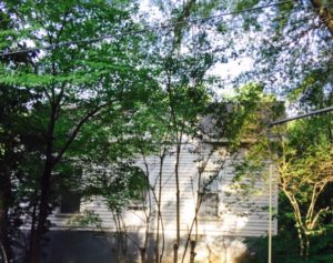
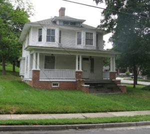
The Paul and Holly Beatty House is a ca. 1911 two-story hipped-roof house that faces west  and is set back approximately 30’ from the granite curbed street.  The four square plan house is a vernacular interpretation of the Prairie Style.   The four square is a house type that developed late in the nineteenth century as a reaction against the ornate and asymmetrical designs of the Queen Anne Style.   Four square houses are generally cube like, and are usually topped with a hipped roof.  The houses are two stories tall, two bays wide, and usually consist of four rooms on each story.  With the wide adoption of indoor plumbing and central heating, the plan was widely adopted across the county.  In the South, the four square largely replaced the one-room-deep I-house.   The four square plan greatly influenced the development of the Prairie Style.  And while high style examples of the Prairie Style (limited to the Mid-West) frequently employed other less cubic house forms, the four square form was almost universally employed in the vernacular examples of the Prairie Style that were built in great numbers across the country.  Elements typically found on the vernacular Prairie Style include, deep overhanging hipped roofs,  substantial half and full height masonry porch piers, and significant second-story window configurations, and hipped dormers.  The four square’s success can be partially attributed to the phenomenal proliferation of the Craftsman Style bungalow.  The bungalow form is a one-story or one-and-one-half-story house form.  Where a two-story house was desired in a bungalow neighborhood, a four square plan was often employed.  By the 1920s, the four square plan was largely abandoned in favor of the popular two-story massed Colonial Revival style.

The neighborhood is a mix of single family houses and small multi-family residential buildings.  Like the Paul and Holly Beatty House, most of the buildings in the neighborhood date from the first half of the 20th century.  Now called “South Irwin Avenue,” the street was originally named “Woodlawn Avenue” and was the center and namesake of the small Woodlawn Neighborhood.  Several lots along Woodlawn are now vacant.  Located to the northwest of the Paul and Holly Beatty House is the Woodlawn Avenue Duplex and a very similar brick quadruplex.  Other than these multi-family buildings, the neighborhoods historic inventory is limited to single-family houses.  Along Woodlawn and in much of the neighborhood all of the houses and apartments are set close to the street, and sidewalks line both sides of the street.  The neighborhood is dominated by mature oak trees.

The front elevation is two bays wide and is dominated by a full-width porch with a low-pitch hipped roof. The porch is supported by continuous brick foundation with three integrated brick half-height piers topped with simple concrete caps.  The pier placement is not symmetrical.  The southmost piers adjoin brick cheekwalls that step down and border replacement wooden steps.  The foundation is pierced by a small three-light sash window.  The brick piers connect to balustrades composed of original chamfered  top rails and simple original narrow balusters. 

The corner piers each support three tapered Craftsman Style posts.  The middle pier supports two posts.  The posts rest on simple wooden bases.  The posts are topped with simple wooden caps with quarter-round trim.  The posts support a boxed beam with a narrow band of cyma trim, probably covering a joint where boards are joined.  The boxed beam is topped by wider cyma trim where the boxed beam meets the soffit.   The deep soffit is sheathed with beaded board.  The house’s low pitched roof, deep soffits, four-square plan, and lack of Craftsman Style architectural features identify it as a vernacular interpretation of the Prairie Style.

The porch shelters a wide one-over-one window and a replacement door.  The is topped with a single-light transom.  The door is bordered on both sides by narrow one-over-one windows.  The porch features simple clapboards used on all of the exterior walls.  The courses of clapboards terminate in corner boards with a moulded round-over detail.   The clapboards on the porch are topped by two-wide wide frieze boards.  The horizontal joint between the boards is covered by narrow cyma trim.  The porch wall is topped with wider cyma trim.  The porch ceiling is beaded board.

The front elevation features two angled bay windows symmetrically set on the second story.   Each bay features a center two-over-two window flanked by narrow one-over-one windows.  The deep overhang of the principal roof shelters the bays.   The clapboard siding terminates in built-up cornerboards with an applied quarter-round.   The low pitched hipped roof features a subtle bell-cast shape.  Centered above the façade is a wide low hipped-roof dormer.  The bell-cast roof design is most distinctive on the relatively small roof of the dormer.  The dormer features two diamond-light windows bordered by short louvered vents.  The dormer is sided with wood shingles.    A corbelled internal chimney centered on the house’s front axis pierces the roof at the junction of the dormer and the principal roof.  A second internal chimney is located to the rear of the roof ridge.


The north elevation is two bays wide and features a projecting rectangular bay window in the rear bay on the first story.  The bay window is composed of a center one-over-one window bordered by two narrow one-over-one windows.  Four sawn brackets support the bay window.  The corner boards feature quarter-round trim.  The short sides of the bay are sheathed with clapboards.  The bay window is topped with a nearly flat roof.  Other first story fenestration on the north elevation is limited to a single tall one-over-on window.  The second story is pierced by two shorter two-over-two windows aligned with the first story fenestration.  A small single-light center-tilt window is located between the double hung windows. The clapboards on the north, south and rear elevations rise from a drip cap that rests on a simple water table board. 


The south elevation is three bays wide.  Its fenestration mirrors the internal functions of the house, and contrasts with the formal symmetry of the façade.  On the first story, moving from the front of the house, the first bay contains a single tall one-over-one window.  The middle bay contains a single-light center-tilt window set low in the wall.  The last bay contains a replacement two-sash casement window.  The new window is roughly of the same dimensions as the window it replaced, however, a taller double-hung window may have occupied the bay.  On the second story the three bays all contain two-over-two windows that are shorter than the one-over-one windows that pierce the first story.  The window in the middle bay is lower than the other two, reflecting the location of an interior stair landing.

A two-story wing extends from the rear of the house.  According to the owner, the house originally featured a small one-story back porch.  At one point the roof featured a handrail.  Later a second story was added for a sleeping porch.   The porch was in poor condition and was replaced with the present narrow wing.  The hipped-roof wing features an enclosed recessed porch on the first story.  Wide posts are infilled with panels and fixed windows.  The second story features a recessed porch.  The hipped roof is topped by a small hipped dormer.

Interior

The interior of the Paul and Holly Beatty House has retained a high degree of integrity, and is receiving a complete renovation.  Plaster walls and ceilings have been repaired, and all woodwork has been stripped of paint.  All windows and a set of interior sliding doors have been repaired. 

The front door opens into a foyer containing a turning staircase with a landing.  The stairs; handrail, balusters, treads and trim are pine, and were originally stained dark.  The handrails are deeply moulded and terminate in square newel posts.  The posts feature a band of cyma recta trim and simple cap with more cyma recta trim.  Balusters are turned with an unusual four-bead detail in the middle of the turned section.  The handrail terminates on the second story in a two piece newel pilaster.  A turned pendant hangs from the newel pilaster.   

The foyer opens into a dinning room.  The dining room connects to a living room via sliding panel doors.  The rooms feature tall baseboards topped with moulded cyma recta trim, picture moulding, and narrow pine flooring.    All windows and doors are bordered by fluted jam trim, and feature moulded casing caps.  Door trim features starter blocks. The living room contains a simple large fireplace surround.  In contrast to the pine woodwork throughout the house, the mantle is crafted from walnut.  The mantle surround is composed of a deep box shelf supported by Doric columns that rise from square bases.  The columns rest on a concrete hearth that was once tiled.  The firebox is surrounded by replacement tile.  The simple design of the fireplace surround reflects the vernacular Prairie Style architecture of the house.  While impressive and well crafted, the other interior architectural features are not specifically related to the Prairie Style.  The woodwork elements found  in the Paul and Holly Beatty House were utilized for decades in Charlotte, from the late Queen Anne Style homes of the turn of the century to the late Craftsman Style homes of the 1930s.  

The front rooms on the second story both contain fireplaces.  The room over the foyer features an oak two-shelf fireplace surround with a large mirror set between the shelves.  The shelves are supported by short  posts with moulded trim.  The firebox contains a cast iron coal grate.  The bedrooms feature pine six-horizontal -panel doors with original hardware, and short six-panel closet doors. The front room over the living room features a pine fireplace surround with fluted pilasters.  The second story hallway contains a recessed fuse box is covered by a panel door, and features the same trim installed around windows. 

The remodeled rear wing is connected by a new door opening on the second story.  The remodeled wing feature new woodwork that replicates the woodwork found in the original sections of the house.  


100, 102, 104, and 106 Main Street, Huntersville
 

This report was written on 25 February 1992

1. Names and locations of the properties: The properties known as the commercial row of four buildings are located at 100, 102, 104, and 106 Main Street, Huntersville, in Mecklenburg County, North Carolina.

2. Names, addresses and telephone numbers of the present owners of the properties: The owners of the properties are:
100 Main Street
Ms. Sara Marlene McCraw
Photography Unlimited, 100 Main Street
Huntersville, North Carolina 28078

Telephone: (704) 875-9718
Tax Parcel Number: 019-041-11
Deed Book 4781, Page 0061

104 Main Street
Mr. Cecil D. Bradford and wife, Beverly C.
P 0. Box 797
Huntersville, North Carolina 28078

Telephone: (704) 875-6775
Tax Parcel Number: 019-041-09
Deed Book 3726, Page 0930

102 Main Street
Mr. Joyce Lee Hager
10400 Sam Furr Road
Huntersville, North Carolina

Telephone: (704) 892-5300
Tax Parcel Number: 019-041-10
Deed Book 3694, Page 0496

106 Main Street
Mr. Jerry Kornegay and wife, Emily
1210 Yuma Street
Charlotte, North Carolina 28213

Telephone: (704) 875-6080 (Business)
Tax Parcel Number: 019-041-08
Deed Book 5144, Page 0214

3. Representative photographs of the properties: This report contains representative photographs of the properties.

4. A map depicting the location of the properties: This report contains maps which depict the location of the properties.


5. Current Deed Book References to the properties: The most recent deeds to the Tax Parcels, as listed in Mecklenburg County Deed Books, are given above in item 2.

6. A brief historical sketch of the properties: This report contains a brief historical sketch of the properties prepared by Ms. Paula M. Stathakis.

7. Brief architectural descriptions of the properties: This report contains brief architectural descriptions of the properties prepared by Ms. Nora M. Black.

8. Documentation of how and in what ways the properties meet criteria for designation set forth in N.C.G.S. 160A-400.5:


a. Special significance in terms of history, architecture, and /or cultural importance: The Commission judges that the properties known as the Commercial Row of Four Buildings does possess special significance in terms of Huntersville and Mecklenburg County. The Commission bases its judgment on the following considerations: 1) the town of Huntersville was chartered on March 9, 1887; 2) Huntersville was a railroad town with Main Street parallel to the tracks; 3) Huntersville’s commercial district began developing next to the railroad tracks as early as 1877; 4) the building at 100 Main Street is a good example of the location of early banks at important intersections as well as the use of the classical style to draw customers; 5) the building at 102 Main Street served the town as a grocery store for much of the 20th century; 6) the building at 104 Main Street is a fine example of an early two-story commercial structure; 7) the building at 106 Main Street is an example of changes that occurred among storefronts in typical commercial rows; and 8) the four buildings, when viewed together, are the last remnant of historic fabric that comprised Huntersville’s once-thriving commercial district.

b. Integrity of design, setting, workmanship materials feeling, and/or association: The Commission contends that the architectural descriptions by Ms. Nora M. Black included in this report demonstrate that the commercial row of four buildings meets this criterion.

9. Ad Valorem Tax Appraisal: The Commission is aware that designation would allow the owner to apply for an automatic deferral of 50% of the Ad Valorem taxes on all or any portion of the property which becomes a designated “historic landmark.” The current appraised value of the improvements, the current appraised value of the land included in the Tax Parcels, and the total appraised value of the properties are given below. The properties are zoned CB.


100 Main Street 102 Main Street
Tax Parcel Number: 019-041-11 Tax Parcel Number: 019-041-10
Improvements = $13,550 Improvements = $15,850
Land = $4,900 Land = $5,360
Total Appraised Value = $18,450 Total Appraised Value = $21,210


104 Main Street 106 Main Street
Tax Parcel Number: 019-041-09 Tax Parcel Number: 01 9-041-08
Improvements = $13,960 Improvements = $17,940
Land = $3,830 Land = $3,830
Total Appraised Value = $17,790 Total Appraised Value = $21,770

Date of Preparation of this Report: 25 February 1992

Prepared by: Dr. Dan L. Morrill in conjunction with Ms. Nora M. Black
Charlotte-Mecklenburg Historic Landmarks Commission
The Law Building, Suite 100, 730 East Trade Street
P 0. Box 35434
Charlotte, North Carolina

Telephone: 704/376-9115


Historical Overview of Commercial Row
 

by P.M. Stathakis

The town of Huntersville is situated fourteen miles north of Charlotte and was chartered on March 9, 1887.1 Like other small towns in Mecklenburg County, Huntersville was a railroad town and it grew as a function of the Atlantic, Tennessee and Ohio Railroad (now the Norfolk Southern Railroad) whose tracks run parallel to Main Street. The track of the A. T.& O. was relaid in 1874; the town that would be known as Huntersville began its development along these tracks in 1877.2 Huntersville was originally called Craighead, N.C. and was later named for a member of the Hunter family. 3

Huntersville was important in the late nineteenth century as a center for higher education. The Huntersville High School Academy, established in 1878, was one of the first of two high schools in western North Carolina. 4 In 1898, Anchor Mills established a plant in Huntersville, adding an element of economic diversity to the predominantly rural region. 5 Some of the more progressive citizens of the town, caught up in the general climate of boosterism of the times, argued in favor of industrial growth for their town as early as the 1880s. Anyone who has taken even a casual interest in the development of Huntersville has encountered a letter written by William Joseph Ranson to Ellen Viola Hunter in 1888, in which Ranson declares that “Huntersville has the factory fever”. 6 In spite of the school and the cotton mill, Huntersville remained a small town and retained its rural character throughout the twentieth century.

A small commercial row grew up along these railroad tracks in the late nineteenth century. What is significant about Huntersville and its small commercial row is that it is exemplary of the rural town in Mecklenburg County. Its development along the railroad connected the town to distant markets and made the town an important commercial center for area farmers and the distribution center for the area cotton crop. The Main Street of Huntersville is similar to the Main Streets of other small Mecklenburg towns, because, like Matthews or Pineville, it is arranged along a railroad. Travelers who went to Huntersville by train arrived in this commercial center of town. The principal stores occupied one side of one block (to the west of the railroad tracks).7

The building on the corner of Main Street and Gilead Road, 100 Main Street, was the site of the North Mecklenburg Bank. Other banks subsequently occupied this building: The Bank of Huntersville, The Bank of Cornelius and First Union National Bank. 8 First Union National Bank sold the building in 1976. 9 It is currently used as a photography studio.

The building immediately south of the bank, 102 Main Street, once housed Smith’s Grocery Store. It was purchased by B. H. and Glenna Smith in 1944 from the Kerns family. 10

The building adjacent to Smith’s Grocery, 104 Main Street, was once Mullen’s Drug Store. The land was purchased by Allen Porter Mullen in 1947. The deed indicates that the land was vacant when he bought it. 11 Earlier deeds for this property note that this lot was originally two parcels, one of which was known as the Post Office building lot. 12 Mention is also made in an early deed that a structure (referred to as a “building”, “house”, and “frame structure” within the same document) stood on this lot in 1907 and that the new owner was restricted from demolishing it until 1908.13

The fourth building in this row, 106 Main Street, was once J. R. McCurdy’s dry goods store. McCurdy bought the property in 1906. According to earlier deeds, a store owned by John and James Woodsides operated on this site as early as 1887.14

Long time Huntersville resident Kate Ranson Cornue recalls that “downtown” formerly occupied three blocks on Main Street. The businesses she remembers are a meat market, Cross’s General Store (later the Ranson Brothers Grocery), J. R. McCurdy’s Dry Goods, Sam Holbrook’s Grocery Store, Mullen’s Drug Store and a barber shop. A long hitching rack used to stand in front of these businesses for shoppers traveling by horse and cart. 15

Now the commercial row sits as an adjunct part of the town. Main Street began to lose its vitality in the 1920s as automobiles became more popular and affordable to the public. The commercial activity shifted to the west, first along NC 115 (Old Statesville Road) and later along the I-77 corridor.


NOTES

1 Legette Blythe and Charles Brockman, Hornet’s Nest: The Story of Charlotte and Mecklenburg County,(McNally of Charlotte, 1961): 421.

2 Richard L. Mattson, Historic Landscapes of Mecklenburg County: The Small Towns. Unpublished manuscript. (July 1991), p. 3. The A. T.& O. Railroad was originally laid in the area in the 1850s. It was removed for use elsewhere during the Civil War, and relaid in 1874.

3 Kate Ranson and Thomas Williams, eds. The Mecklenburg Gazette Magazine Supplement “A Huntersville Album” December 13, 1979.

4 Blythe and Brockman, p. 421.

5 Mattson, p. 5.

6Ranson and Williams.

7 Mattson, p. 5 .

8 See deeds 4781-61, 1-23-84; 436-366, 1-7-21; 862-335, 3-735; 3863-50, 7-29-76, in Mecklenburg County Court House, Register of Deeds.

9 Deed 3863-50, 7-29-76.

10 Deed 1136-61, 11-2-44. Historic Structures short data report by Mary Beth Gatza, 3-15-88.

11 Deed 1228-123, 1-16-47.

12 Deed 1156-563, 5-17-45.

13 Deed 226-108, 6-27-07.

14 Deed 216-497, 10-19-06.

15 Kate Ranson Cornue, Mecklenburg Gazette “I Remember When”, Clippings File: Huntersville. Charlotte-Mecklenburg Public Library.


Architectural Sketches: Commercial Row of Four Buildings on Main Street Huntersville, North Carolina
 

Prepared by: Ms. Nora M. Black

Most of the commercial buildings that made up the railroad frontage of the town of Huntersville have been demolished over the years. The few early buildings remaining on quiet Main Street seem far removed from the rush of traffic on Interstate 77 or even busy Gilead Road. But it wasn’t always so quiet on Main Street. Once the trains stopped in Huntersville, discharging noisy passengers and taking on travelers from the surrounding countryside. Once the farmers from north Mecklenburg County came to Huntersville to sell their crops, buy their supplies, and negotiate a loan for seed and fertilizer with the local banker. In the book, North Carolina Architecture, the author has said, “Main Street, North Carolina, developed rapidly in the period from 1900 to 1930, assuming a character it retained throughout most of the century. The small towns … depended on sales and manufacturing of local staples, cotton and tobacco, and forest products; their buildings and their businesses provided the link between the still agrarian society and the national marketplace.” 1 Huntersville was no exception to the Main Street development just described.

The composition and character of the early town of Huntersville was determined to a great extent by the building types and materials found in the Main Street buildings. Main Street was given over to commercial development at its intersection with Huntersville-Concord Road; residential development was pushed away from the railroad tracks. In cities such as nearby Charlotte, the open-plan department store stood as the emblem of an emerging consumer society at the beginning of the 20th century. The composition of Huntersville, lacking a single store that covered most of a block, obtained a grander visual effect by having several narrow twenty-five to thirty foot wide stores integrated into large blocks sharing party walls. The use of brick as a building material provided a greater measure of safety from fires than the timber and weatherboards used for early commercial structures. The freestanding narrow retail stores, with their deep shadowy back sections fifty to sixty feet from the large storefront windows, are typical of the vernacular buildings found in crossroad towns and railroad villages across America. Faint echoes of high-style sources are abstractly simple ornamental details … Often only minor features such as brick patterning at the eaves … are indicative of the particular period.” 2

Although the four buildings present an unbroken front, each is different in style and material. That difference is apparent to even the most casual observer walking down Main Street in Huntersville.


Architechtural Sketch: 100 Main Street
 

The building at 100 Main Street is located on the west side of Main Street at the intersection of Huntersville-Concord Rd. The front, or east, facade of the building faces Main Street; the rear, or west, facade faces Maxwell Avenue. The building, containing 1,275 square feet, is located on a rectangular-shaped lot (roughly 30′ wide on Main Street by 102′ deep) owned by Ms. Sara Marlene McCraw and houses “Photography Unlimited”. A wide sidewalk runs along the north side of the building facing Huntersville-Concord Rd.

The building at 100 Main Street is a vernacular interpretation of the classical style. The use of the classical style for banks at the turn of the century was the beginning of a departure from the standard commercial style of building commonly used for early banks in North Carolina. As Bishir points out, ” Banks were typically located on prominent downtown sites, often at major intersections. Such buildings were planned to take good advantage of their sites, with architectural emphasis on the side as well as front elevations.” 3 The north side of the former bank is the only side wall exposed in the commercial row of four buildings; classical ornament continues along this side. The ground plan is a linear plan that is three units deep. The building presents a symmetrical, one story, three bay elevation to Main Street. A parapet above the cornice conceals the flat roof from view.

The building is constructed of dark reddish-brown brick laid in running bond. The mortar in the recessed joints is colored to match the bricks. A simple sheet metal cornice with a wide frieze decorates the front (east elevation) and the long north side. Below the frieze, a molding trims the building at the height of the tops of the doors and windows. Wide brick pilasters terminate at the molding. The front of the building has three metal vents in the parapet between the concrete coping and the cornice; the north side has four vents. The owner was having the trim painted dark gray at the time this report was prepared.

The flat roof is pitched only 11 degrees from the front to the back. The tin roof was “rolled off like a sardine can lid by Hurricane Hugo” 4 in 1989. The tin roof was replaced with a rubber membrane material. A brick chimney on the north side of the building still serves the building’s heater.

The large plate glass windows in the storefront and the side of the building are topped with fixed, multiple-pane sash. Two windows on the north are double hung wooden sash; each sash contains a single large pane of glass. Windows on the rear facade have brick infill.

The front elevation is three units wide with the widest units being the two rectangular windows on either side of the front door. The front door forms the center unit. Brick pilasters with concrete bases define the entry. The front entry has a wooden door with one lower wooden panel and a large panel of glass; the age of the hardware varies. A granite threshold meets the concrete sidewalk.

Parts of the interior of the building at 100 Main Street have been modernized. The rooms have original painted moldings and wooden six-panel doors. Walls are of plaster. Although the exterior looks like a one-story building, a sheetrock ceiling was laid in by a previous owner. The installation of that ceiling created a second floor which the current owner uses for storage. The second floor can only be reached by means of a disappearing stair. The new ceiling could easily be removed to restore the building to the original one-story layout; however, almost all of the pressed tin ceiling panels have been removed from the second floor ceiling leaving the supporting wood and roof sheathing exposed.

Original mosaic tile with a Greek fret or meander border defines the customer area of the bank. The original wood flooring of the teller area was still in place until Hurricane Hugo rolled the tin roof off the building. The water that came in during the storm damaged the tongue-and-groove flooring; it was warped beyond repair. Because the wood actually laid on the ground (and had suffered some termite damage over the years), the insurance company required the owner to have a concrete slab poured in the areas that were originally wood. Most of that concrete is covered with carpet at this time.

The front door opens to a large rectangular room that originally served as the banking area. A gas furnace, with a manufacture date from the 1930’s, provides heat. The current owner believes that the original heating system used coal due to the large amount of coal fragments found at the rear of the building. A partition near the rear runs the width of the building. The door to the vault is on the north side of the partition. The single metal outer door conceals two narrow paneled inner doors. Extra tongue-and-groove flooring provided material for vault shelves for the builders. A door on the south side of the partition opens to a hallway. A small bathroom and a back room (now used as a darkroom) take the rest of the space at the rear of the building.

The building at 100 Main Street anchors the balance of the commercial row with simple, classical elegance. The current owner plans to continue using the building as a photography studio. Under her ownership, it would be maintained in its present style.


Architectural Sketch: 102 Main Street, Huntersville, North Carolina
 

The building at 102 Main Street is located on the west side of Main Street. The front or east facade of the building faces Main Street; the rear or west facade faces Maxwell Avenue. The building, containing 2,100 square feet, is located on a rectangular-shaped lot (roughly 35′ wide on Main Street by 102′ deep) owned by Mr. Joyce Lee Hager. It houses “Measurement Controls, Incorporated,” a company which assembles gas meters. Number 102 shares party walls with 100 Main Street and 104 Main Street.

The building at 102 Main Street is built in a simple commercial style. Although it presents two separate entry bays, Number 102 appears to have been constructed as a single unit. According to the Mecklenburg County tax records, the ground plan is linear. The building presents a slightly asymmetrical one-story, two-bay elevation to Main Street. A parapet with a coping of one course of rowlock brick conceals the flat roof from view. The building is constructed of rough textured red-orange brick laid in running bond with white mortar joints. A soldier course of brick spans the metal header over the storefront windows and recessed entries. Recessed panels of brick over each storefront were designed to hold signs. There is a single metal vent centered in each storefront above the soldier course of brick.

Most of the large display windows in the storefront are covered with plywood or waferboard. Only two windows in the north storefront are uncovered. A small window with a sliding panel has been installed in the covering of the southernmost window. Brick bulkheads, used to support the weight of the windows, are original. The low bulkheads extend across the front of the building and into the recessed entrances. There are vents in the bulkheads on each side of the recessed entrances. Some painted glass panels (possibly structural glass) are visible over the northern storefront. Window openings on the rear facade are of the same size, but vary in finish. The extreme south window has an infill of concrete blocks; the next window is an industrial style with metal frame; beyond that is a window covered with plywood with an insulated duct running through its center; and the extreme north window has an infill of concrete blocks. There are brick chimneys on both the north and south party walls.

The front elevation consists of two storefronts with each defined by a three part, window-recessed door-window arrangement. The door of the north storefront forms the center unit. The original double door, evidenced by the width and divided transom above, has been reduced to a single door. The door of the south storefront is covered. A window air conditioning unit has been installed in the transom area. Both entries have concrete pavers laid on a slight rise from the sidewalk. Same width boards cover the ceilings of the recessed entries.


Architectural Sketch: 104 Main Street, Huntersville, North Carolina
 

The building at 104 Main Street is located on the west side of Main Street. The front or east facade of the building faces Main Street; the rear or west facade faces Maxwell Avenue. The building, containing 2,325 square feet, is located on a rectangular-shaped lot (roughly 25′ wide on Main Street by 102′ deep) owned by Mr. Cecil D. Bradford and wife, Beverly C. Bradford. It is vacant and shares party walls with 102 Main Street and 106 Main Street.

The building at 104 Main Street is older than the two buildings previously discussed. Mecklenburg County tax records list 1906 as the year built; however, officials at the Tax Office indicated that it could have been built earlier. It is built in a commercial style typical of the late 1800’s to early 1900’s. This is evidenced by the corbelled brick cornice and arched windows of the upper story. According to the Mecklenburg County tax records, the ground plan is linear. The building presents a symmetrical two-story elevation to Main Street. A parapet with a corbelled brick cornice of four courses of brick conceals the flat roof from view. It appears that the upper courses of the cornice were once covered with a skim coat of concrete. The building is constructed of smooth mixed color bricks (ranging from red to red-orange to brown) laid in common bond with sixth course headers. The courses of headers are mostly dark brown and black as if they had been fired near the center of the kiln. A rowlock course of brick spans the former display windows and recessed entry. Slight variations in the size of the bricks are evident.

The large display windows in the storefront are covered with plywood. Brick bulkheads, used to support the weight of the windows, are constructed of newer brick and, although old, do not appear to be original. The low bulkheads extend across the front of the building and into the recessed entrances. The vent system in the bulkheads is distinguished by the use of a rowlock course of brick with every other brick missing. The bulkheads form engaged columns at the corners of the recessed entrance. The column is continued in wood to the frieze board. The second floor has two large window openings covered with painted plywood. The window openings are topped by segmental arches of two rowlock courses of brick and have sills of two courses of brick. Window openings on the rear facade are of the same size and finish.

The front elevation is defined by a three part, window – recessed door window arrangement. The double door forms the center unit. Like the windows, the doors are covered by plywood. The entry has square pavers laid on a slight rise from the sidewalk. The recessed entry has a beaded board ceiling.

The rear elevation has two arched windows on the second floor similar to the front elevation. On the first floor, arched windows flank the arched double doors. The southernmost window opening is covered with a door rather than plywood.

A coat of smooth stucco covers the back wall from the ground to the second floor window sills. A white aluminum gutter and two downspouts drain the water from the roof.

The second floor side elevations do not appear to have any openings or windows. The side parapets step down in three steps from the front of the building to the rear and are corbelled in the same manner as the front parapet. There is a single brick chimney with a corbelled top on the north party wall.

The building at 104 Main Street is unique in that it is the only two story building in the Huntersville commercial row. In fact, Mrs. Bradford remarked that 104 Main Street is “Huntersville’s only skyscraper.” 6


Architectural Sketch: 106 Main Street, Huntersville, North Carolina
 

The building at 106 Main Street is located on the west side of Main Street. The front or east facade of the building faces Main Street; the rear or west facade faces Maxwell Avenue. The building, containing 1,553 square feet, is located on a rectangular-shaped lot (roughly 25′ wide on Main Street by 102′ deep) owned by Mr. Jerry Kornegay and wife, Emily Kornegay. It is currently used to store laundry equipment. Mr. Kornegay believes that it served the town as a laundromat for approximately thirty years, closing in 1988. 7 Number 106 shares party walls with 104 Main Street and 108 Main Street (not included in this report).

The building at 106 Main Street is a simple commercial style of the early 1900’s with a couple of facade changes. Mecklenburg County tax records list 1924 as the year built; however, officials at the Tax Office indicated that it could have been built earlier. According to the Mecklenburg County tax records, the ground plan is linear. The building presents a symmetrical one-story elevation to Main Street. just as 104 Main Street, the front elevation is defined by a three part, window – recessed entry with door – window arrangement. A parapet with a coping of one course of rowlock brick topped with concrete conceals the flat roof from view. The building is constructed of smooth yellowish to red-orange brick laid in common bond with sixth course headers. As seen in 104 Main Street, the header courses are mostly dark brown and black as if they had been fired near the center of the kiln. Mortar used matches the tone of the bricks. A decorative panel of brick is set three courses below the coping of the front parapet. It consists of a rowlock course and a soldier course of brick turned on the diagonal. The decorative panel spans most of the front of the building. Two stretcher courses of corbelled brick add even more texture to the wall. A recessed panel of brick at the center of the storefront was designed to hold a long, narrow sign.

A metal canopy spans the width of the building. Since it is not original, it could easily be removed to show the entire storefront without the visual isolation now imposed on the upper portion of the facade. The large six-panel display windows with thick wooden muntins are not original. Brick bulkheads, used to support the weight of the windows, were added at some point. A single rowlock course of brick provides a sill for the windows. The brick of the bulkheads is newer than the brick of the rest of the facade. Mortar used in the bulkhead joints is white. It is a machine made brick with an incised wave pattern. The low bulkheads extend across the front of the building and into the recessed entrance. A steel door with a small square opening (unglazed) has been installed for security. A wooden panel covers the ceiling of the recessed entrance. Each side has a three panel display window. There is a single low step from the sidewalk to the concrete floor of the recessed entrance and another step at the threshold.

Window openings on the rear facade, covered with painted plywood, have segmental arches of two courses of rowlock brick. The two window openings flank the arched double doors. At some point, a portion of the arch over the double doors was closed with incised brick like that found in the bulkheads on the building’s front; replacement doors were installed in the smaller opening. The newer, incised brick also replaced the smooth red-orange brick between the doorway and the north window. There are two metal chimneys near the rear of the building. Side elevations of 104 Main Street are not visible since the adjoining buildings are two-story structures.

The front door opens to a room that encompasses almost the entire building. The only enclosed areas, rest rooms and a small mechanical room, are in the south corner at the back of the building. The floor is of concrete with some traces of floor paint still visible. The plaster walls are painted yellow and white. White panels with narrow battens cover the ceiling. Rows of washers and dryers line the room. A gas unit heater hung from the ceiling provides heat. A sodium vapor street lamp provides light. There is a column in the center of the building, but it is not structural. It enclosed water pipes for the two rows of washing machines in the center of the building. Dryers lined the side walls.


Conclusion
 

The Main Street commercial row of four buildings in Huntersville is an intact example of the growth of a commercial architectural style from the last years of the 19th century into the middle of the 20th century. It is vital to an understanding of Huntersville’s development because of its orientation to the railroad tracks. The finishes and decorative details of the four buildings are restrained and simple in contrast to the architectural details found in urban centers of the same period. It is not so hard to imagine the turn of the 21st century with light rail passenger trains stopping in Huntersville across the street from a revitalized commercial row. Noisy commuters could walk to a small grocery for dinner supplies. They could stop at a photography studio to pick up their kid’s graduation pictures. A pharmacy could supply a bottle of aspirin while the laundry/ dry cleaner could have clean shirts waiting. These four handsome buildings, three in use everyday, remain as a core providing development opportunity in Huntersville.


Notes

1 Catherine W. Bishir, with photography by Tim Buchman, North Carolina Architecture. (Chapel Hill, North Carolina, 1990), 400.

2 Carole Rifkind, A Field Guide to American Architecture. (New York, 1980), 193-195.

3 Bishir, 403-405.

4 Interview with Ms. Sara Marlene McCraw, 15 February 1992.

5 B. Clarkson Schoettle, ‘Keeping Up Appearances: Storefront Guidelines,’ Main Street: A Publication of the National Trust for Historic Preservation, 1983,1-16.

6 Telephone Interview with Mrs. Beverly C. Bradford, I 1 February 1992.

7 Interview with Mr. Jerry Kornegay, 15 February 1992.


Beaty House

This report was written on 28 February 1990

1. Name and location of the property: The property known as the W. D. Beaty House is located at 2400 Park Lane in Charlotte, N. C.

2. Name, address and telephone number of the present owner of the property: The owner of the property is:

Mrs. Mary B. Kelly
2716 Dellinger Circle
Charlotte, North Carolina 28213

Telephone: (704)596-5747

Tax Parcel Number: 055-294-06

3. Representative photographs of the property: This report contains representative photographs of the property.

4. A map depicting the location of the property: This report contains maps which depict the location of the property.


5. Current Deed Book Reference to the property: The most recent deed to this property is listed in Mecklenburg County Deed Book 6061 at page 689. The Tax Parcel Number of the property is 055-294-06.

6. A brief historical sketch of the property: This report contains a brief historical sketch of the property prepared by Ms. Mary Beth Gatza.

7. A brief architectural description of the property: This report contains a brief architectural description of the property prepared by Ms. Mary Beth Gatza.

8. Documentation of why and in what ways the property meets criteria for designation set forth in N.C.G.S. 160A-400.5:


a. Special significance in terms of its history, architecture and /or cultural importance: The Commission judges that the property known as the W. D. Beaty House does possess special significance in terms of Charlotte-Mecklenburg. The Commission bases its judgment on the following consideration: 1) the W. D. Beaty House was owned by the second son of James M. Beaty, early 19th century Mecklenburg County landowner; 2) the ca. 1880 W. D. Beaty house is architecturally significant as representing a late 19th century interpretation of the National Folk (post-railroad) house form; 3) the two story I-house has elaborate Folk Victorian details such as cornice returns, brackets, and flat, jigsaw cut trim; 4) interior details such as the curved stair are examples of a high level of local craftsmanship; and 5) the property is of similar construction to 1880’s houses in Gaston County by Lawson Henderson Stowe, builder.

b. Integrity of design, setting, workmanship, materials, feeling, and/or association: The Commission contends that the architectural description by Ms. Mary Beth Gatza which is included in this report demonstrates that the W. D. Beaty House meets this criterion.

9. Ad Valorem Tax Appraisal: The Commission is aware that designation would allow the owner to apply for an automatic deferral of 50% of the Ad Valorem taxes on all or any portion of the property which becomes a designated “historic landmark.” The current appraised value of the improvements is $35,640. The current appraised value of the 2.19 acres is $21,600. The total appraised value of the property is $57,240. The property is zoned R-12.

Date of Preparation of this Report: 28 February 1990

Prepared by: Dr. Dan L. Morrill in conjunction with Nora M. Black
Charlotte-Mecklenburg Historic Landmarks Commission
1225 South Caldwell Street, Box D
Charlotte, North Carolina 28203

Telephone: 704/376-9115


Historical Overview
 

M. B. Gatza
September, 1989

William D. Beaty (1838-1905) was the second son of landowner, James M. Beaty (1800-1889). 1 James M. Beaty owned 632 acres, on three separate tracts, and no less than three dwelling houses when he died in 1889. 2 As his share of the estate, W. D. Beaty received a 64 1/2 acre tract along the Catawba River, which included a house, but he may never have resided there. W. D. Beaty married Mary E. Kinkaide in 1869, and together they had at least six children. 3

W. D. Beaty purchased 98 1/2 acres in 1891 from J. W. S. and Martha Todd for $1500, and this house was most likely standing on it at the time. The deed of 1891 has a clause which reads (in part):


“…the said Martha I. Todd …doth… release… unto the party of the second part… all her right of dower and of the homestead in the above described land…”

Evidently, she was a widow, and probably acquired this property through her husband. The property could have transferred to her automatically upon his death, and therefore, no deed was recorded. Her maiden name and previous married name are unknown. They were living alone together by 1870, and in 1880, they were housing three boarders and one servant (a cook). 4

In 1905, W. D. Beaty passed away, leaving a will which mentions, among other things, the house. He bequeathed to his


“wife, M. E. Beaty … all my land (98 acres) on which I now live, all my household and kitchen furnishings, horses, mules, cattle of all kinds, all notes and any money…”

He further stipulates,


” at the death of my beloved wife, my son J. C. Beaty [is to receive] 65 acres of land of off [sic] the South end of my place, the same to include the dwelling in which I now live and outbuildings at his death to be divided among his children.”

The remaining 34 acres was to go to his daughter, Mrs. Fanny B. Ridnehour, with instructions to sell the mineral rights, if she should ever be offered a good price. One-half interest in the mineral rights on Fanny’s tract was to belong to James C. 4 Family tradition tells of a former mine on the property, however, it is not known if gold or any other mineral was ever extracted from the site. 5

After the death of Mary Beaty, James C. Beaty did take possession of the residence and 98 1/2 acres. He married Margaret Harris (“Hattie”) McConnell in 1897, and together they had twelve children, at least eight of whom lived to maturity. 6 James C. Beaty was a farmer, and grew cotton, corn and other crops on the land. In his later years, he ran a telephone switchboard out of the house, presumably serving the Paw Creek and Berryhill areas. He died in 1923, at the age of 53, of Bright’s Disease.

Hattie Beaty continued living in the house for about seven years. Around 1930, she traveled to Michigan to be with a daughter, Isabell, who was residing there with her husband, Lawrence Otis Dawley. While in Michigan, Hattie met and married Joseph F. Forrest in 1931. She returned a few years later, without her husband, and resumed occupancy at the homeplace. During the 1920s and 1930s, a son, James Fredrick Beaty is known to have resided in the house. At least two of his six children were born in the house (in 1926 and 1932), however, he never held title to it. 7

When Hattie died in 1942, she left the property to her children and the only son of her daughter Isabell, Otis Dawley. Several of the heirs sold off their portions of the land, which has resulted in a small subdivision surrounding the house. Mr. Dawley still resides in the house, which is now being restored by a daughter of James Fredrick Beaty.


NOTES

1 Population Schedules of the Eighth Census of the United States, 1860: North Carolina (Washington: National Archives Microfilm Publications), Mecklenburg County.; Interview with Mary Frances Kelly, Charlotte, North Carolina, August 1989; Robert H. Swain, “Descendants of James Morris Beaty of Paw Creek, N. C.” Charlotte, N. C., 1987. (Typewritten).

2 “Petition for Partition,” Mecklenburg County “Orders and Decrees” Book 4, p. 1.

3 Interview with Mary Frances Kelly; Tenth Census: 1880.

4 Mecklenburg County Deed Book 77, page 254; Population Schedules of the Ninth Census of the United States, 1870: North Carolina (Washington, National Archives Microfilm Publications), Mecklenburg County; Population Schedules of the Tenth Census of the United States, 1880: North Carolina (Washington, National Archives Microfilm Publications), Mecklenburg County.

4 Will Book O, p. 346, Mecklenburg County.

5 Interview with Mary Frances Kelly.

6 The eight adult children of James C. and Hattie Beaty were: William Harvey (b. 1898), Robert Lee (b. 1900), Nellie Jane (b. 1902), James Fredrick (b. 1903), Mary Isabell (b. 1905), Agnes, James C., Jr., and Calvin McConnell Beaty. One boy and two twin girls, Catherine and Cathleen, died in infancy.

7 Interview with Mary Frances Beaty.


Architectural Description
 

M. B. Gatza
September, 1989

The W. D. Beaty House faces east, now toward Park Lane, on a very suburban street. At the time it was built, around 1880, it would have been at the end of a long dirt drive and overlooked fields or woodlands. The closest thoroughfare is Tuckaseegee Road, about a quarter of a mile away.

The house stands two stories tall and three bays across, with two exterior end chimneys and a two-story rear ell. The side-gabled roof is of moderate pitch. The exterior end chimneys are laid up in five-course common bond brick and have corbelled bases (now concealed beneath stucco) and freestanding stacks. Two, four-light, fixed-sash windows are found in the attic level astride each chimney. Six-over-six double-hung sash windows are found elsewhere throughout the house. The splayed front door surround features a glazed transom and sidelights. The individual lights in the door surround have clipped corners, and from a distance give the impression of being curved. Originally weatherboarded, the house was sheathed in asbestos shingle during the middle years of the twentieth century. The roof is covered with asphalt shingles.

The house retains much (if not all) of its elaborate trim. A wide frieze runs the length of the cornice on both the main block and rear ell, and holds scroll brackets. The brackets are repeated on the front porch, and are supplemented there with sawn corner brackets. Delicate, chamfered posts support the hipped porch roof.

On the interior, the most striking feature is the graceful curved stair. Thin balusters climb the length of the stair, leading from a bold, turned newel post. The stair ends, however, are plain. The door and window surrounds are simple, and consists of a plain, two-part molding. A narrow door decorated with wood graining was found in a room upstairs, but is thought to have originally been located on the first floor. Two exterior doors, also wood-grained, were found hanging on an outbuilding. One was obviously the front door, as the applied molding echoes the pattern of the glazing on the door surround. The interior wall surfaces are of plaster applied over sawn laths.

There are side porches on both the north and south elevations of the rear ell. The one to the north is L-shaped and shields the ell and also the rear elevation of the house. Neither porch is original to the house, although they have probably replaced earlier porches in the same configuration. Both porches consist of concrete bases, plain wooden posts and hipped roofs.

Based on physical evidence, it is thought that the house dates from c. 1880. While the attic-level windows and curved stair would suggest an earlier date of construction, examples of both features dating from the 1880s have been found in neighboring Gaston County. There are a handful of houses in southeast Gaston County known to be the work of a local builder which share some distinguishing features with the Beaty House . 1 It is entirely possible that this builder, Lawson Henderson Stowe, also worked in Mecklenburg and constructed this house as well.


NOTES

1 Namely, the curved staircase, two-story rear ell, bracketed cornice and elaborate porch trim. Of the four houses in Gaston County attributed to Stowe, at least two contain a curved stair, two have a two-story rear ell, and all have a bracketed cornice with a clearly-defined frieze. While none of these features by themselves constitute sound evidence, the combination suggests that this house dates from the same decade as the Gaston County examples, and is probably of the same hand.


Bagley-Mullen House

This report was written on May 2, 1979

1. Name and location of the property: The property known as the Bagley-Mullen House is located at 129 N. Poplar St. in Charlotte, N.C.

2. Name, address, and telephone number of the present owner and occupant of the property: The present owner and occupant of the property is:

Charles H. Litaker Insurance Co.
129 N. Poplar St.
Charlotte, N.C. 28201

Telephone: 334-4685

3. Representative photographs of the property: Representative photographs of the property included in this report.

4. A map depicting the location of the property: This map contains a map depicting the location of the property.


5. Current Deed Book Reference to the property: The most recent reference to this property is recorded in Mecklenburg County Deed Book 1230, Page 552. The Tax Parcel number of the property is 078-016-08.

A brief historical sketch of the property:

On October 5, 1892, Edgar Murchison Andrews (1850-1920), a native Charlottean and son of Ezra Hamwood Andrews and Sarah Bolton Andrews purchased property at the corner of N. Poplar St. and Fifth St. in Charlotte, N.C. 1 E. M. Andrews, is best remembered locally for his role in establishing the Andrews Music Co., a corporation which continues to operate in Charlotte. 2 In 1881 he had opened a furniture store on W. Trade St. 3 Soon thereafter, he had brought his brother, Frank H. Andrews, into the business for purposes of managing a music room in which pianos and organs were to be sold. 4 The significance of this activity notwithstanding, it was the second of his business ventures which makes E. M. Andrews a pivotal figure in the architectural history of this community. In the opinion of one observer, E. M. Andrews was “the first man in Charlotte who built nice homes on back streets.” 5 Like the majority of towns in North Carolina, Charlotte had expanded initially along its major thoroughfares, Tryon St. and Trade St. The more imposing residences of the community were located on these two streets. 6 Andrews, responding to the growing demand for substantial dwellings to house the many newcomers who settled in Charlotte in the 1880’s and 1890’s, invested in lots on streets which intersected the major thoroughfares. Here he erected homes for sale. Edward Dilworth Latta, President of the Charlotte Consolidated Construction Company and developer of Dilworth (Charlotte’s initial streetcar suburb), stated that E M. Andrews did more to make Charlotte a livable city than any ten men of his day. 7 E. M. Andrews moved to Greensboro, NC, c. 1905, where he died on July 13, 1920. 8

E. M. Andrews erected a two and one-half story brick house at the corner of W. Fifth St. and N. Poplar St. The initial owner and resident was Andrew Joyner Bagley (1856-1931), who purchased the house in March 1895. 9 A native of Johnston County, N.C., he came to Charlotte from Shelby, N.C., to accept a position in the freight office of the Carolina Central Railroad. 10 Later he became assistant ticket agent for the Southern Railroad. 11 His wife, Bertha Ward Bagley, died in Charlotte on September 8, 1896. 12 On March 4, 1897, he sold his home and, moved out of the city. He settled in Lincolnton, N.C., where he died on February 26, 1931. 13

The next owner of the house was Walter Nixon Mullen (1853-1910), Elizabeth City, N.C. He had come to Charlotte in the late 1870’s and had opened a grocery store on S. Church St. By 1897 he had achieved the accolades of his neighbors, primarily because of his invention of the “Hornet’s Nest Liniment,” a widely-acclaimed medicinal brew of that day. 14 The Evening Chronicle explained that he “made a lucrative living from the much advertised and meritorious composition.” 15 A member of Trinity Methodist Church, Walter Mullen died in the house on February 17, 1910. 16 “He was gentle in manner, kind in speech, unselfish, honest in heart and life, square in his dealings, in exemplary husband and father,” The Charlotte News proclaimed. 17 In the opinion of The Evening Chronicle, W. N. Mullen “had been one of the best known most popular citizens of this community.” 18

On December 30, 1946, the descendants of, Walter Mullen and his wife, Annie Beatrice Grimes Mullen (1859-1925), sold the house to the Charles H. Litaker Insurance Company. 19 That firm has used the structure as its corporate headquarters.


NOTES

1 Charlotte Observer (February 13, 1938), sec. 3., p. 7. Mecklenburg County Dead Book 84, p. 142.

2 The Andrews Music Co. is now located in the Eastland Mall Shopping Center in suburban Charlotte, NC.

3 Charlotte Observer (February 139 1938), sec. 3., p. 7. Charlotte City Directory, 1893-94, p. 34.

4 “Frank H. Andrews” a Folder in the Files of the Carolina Room in the Charlotte- Mecklenburg Public Library.

5 Charlotte Observer (February 13, 1938). sec. 3, p 7.

6 See Beers Map, 1877.

7 Charlotte Observer (February 13, 1938). sec. 3, p. 7. 8 Charlotte Observer (July 14, 1920) p. 1. The Charlotte News (July 14, 1920) p. 15.

9 Burial Records of Elmwood Cemetery, Charlotte, N.C. Mecklenburg County Deed Book 1125 p. 107.

10 Burial Records of Elmwood Cemetery, Charlotte, N.C. Charlotte Daily Observer (January 10, 1895), p. 2.

11 Charlotte City-Directory, 1896-97, p. 56.

12 Burial Records of Elmwood Cemetery, Charlotte, N.C. Bagley was a music teacher and operated a boarding house in her residence (Charlotte City Directory, 1896-97, p. 56 ) .

13 Mecklenburg County Deed Book 116, p. 539. Burial Records of Elmwood Cemetery, Charlotte, N.C.

14 Charlotte Observer (February 18, 1910), p. 2.

15 The Evening Chronicle (February 17, 1910), p. 1.

16 Charlotte Observer (February 18, 1910), p. 2.

17 The Charlotte News (February 17, 1910), p. 12.

18 The Evening Chronicle (February 17, 1910), p. 1.

19 Mecklenburg County Deed Book 1230, p. 552. Burial Records of Elmwood Cemetery, Charlotte, N.C., Charlotte News (February 17, 1910), p. 12.


7. A brief architectural description of the property: This report contains an architectural description of the property.

8. Documentation of why and in what ways the property meets the criteria set forth in N.C.G.S. 160A-399.4:


a. Historical and cultural significance: The historical and cultural significance of the property known as the Bagley-Mullen House rests upon three factors. First, the structure was built by E. M. Andrews, a founder of the Andrews Music Company and, even more importantly, a pivotal figure in the architectural history of Charlotte, N.C. Second, the house served as the abode of Walter N. Mullen, a leading entrepreneur of the community. Third, the structure is the only local example of the Chateauresque style of architecture.

b. Suitability for preservation and restoration: The overall exterior integrity of the structure survives. The interior has been substantially altered, but many of the details on the interior are extant. On balance, the structure is suitable for preservation and/or restoration.

c. Educational value: The Bagley-Mullen House has educational value because of the historical and cultural significance of the property.

d. Cost of acquisition, restoration. maintenance or repair: At present, the Commission has no intention of purchasing the fee simple or any lesser included interest in this property. The Commission presently assumes that all costs associated with restoring and preserving the structure will be paid by the owner or subsequent owner of the structure.

e. Possibilities for adaptive or alternative use of the property: Obviously, the property is highly suited for adaptive use. Indeed, it has been the headquarters of an insurance company for over thirty years. Worth noting in this regard is the fact that the property is zoned B3.

f. Appraised value: The current tax appraisal value of the .139 acres of land is $18,150. The current tax appraisal value of the improvements on the property is $10,690. The most recent tax bill on the land and improvements was $490.28. The Commission is aware that the owner could apply annually for an automatic deferral of 50% of the Ad Valorem taxes on those portions of the property which are designated as “historic property.”

g. The administrative and financial responsibility of any person or organization willing to underwrite all or a portion of such costs: As stated earlier, the Commission presently has no intention of purchasing the fee simple or any lesser included interest in this property. Furthermore, the Commission presently assumes that all costs associated with the property will be paid by the present or subsequent owner of the property.


9. Documentation of and in what ways the property meets the criteria of the National Register of Historic Places: The Commission judges that the property known as the Bagley-Mullen House does meet the criteria of the National Register of Historic Places. Basic to the Commission’s judgment is its knowledge that the National Register of Historic Places, established by the National Historic Preservation Act of 1966, represents the decision of the Federal Government to expand its recognition of historic properties to include those of local, regional and state significance. The Commission believes that the investigation of the Bagley-Mullen House contained herein demonstrates that the property is of local historic importance. Consequently, the Commission judges that the property known as the Bagley-Mullen House does meet the criteria of the National Register of Historic Places. Specifically, the Commission judges that the property known as the Bagley-Mullen House does meet the criterion that properties listed in the National Register of Historic Places must “embody the distinctive characteristics of a type, period, or method of construction.”

10. Documentation of why and in what ways the property is of historical importance to Charlotte and/or Mecklenburg County: The property known as the Bagley-Mullen House is historically important to Charlotte for three reasons. First, the structure was built by Edgar Murchison Andrews, a founder of the Andrews Music Co., and even more importantly, a pivotal figure in the architectural history of Charlotte, N.C. Second, the house served as the abode of Walter N. Mullen, a leading entrepreneur of the community. Third, the structure is the only local example of the Chateauresque style of architecture.


Chain of Title

1. Mecklenburg County Deed Book 1230, Page 552 (December 30, 1946).
Grantor: J. R. & M. R. Mullen, B. F. & C. D. Mullen, Ann S. Mullen, Jessie M. Barbour.
Grantee: Charles H. Litaker Insurance, Inc.

2. Mecklenburg County Will Book Z, Page 418 (1939).
Devisor: E. G. Mullen.
Devisee: Jessie Mullen Barbour.

3. Mecklenburg County Will Book T. Page 154 (September 2, 1925).
Devisor: A. G. Mullen.
Devisee: E. G. Mullen.

4. Mecklenburg County Deed Book 228, Page 504 (February 17, 1908).
Grantor: Walter N. Mullen.
Grantee: A. G. Mullen.

5. Mecklenburg County Deed Book 116, Page 539 (March 4, 1897).
Grantor: A. G. Bagley.
Grantee: Walter N. Mullen.

6. Mecklenburg County Deed Book 112, Page 107 (January 10, 1895)
Grantor: E. M. Andrews.
Grantee: A. G. Bagley.

7. Mecklenburg County Deed Book 84, Page 142 (October 5. 1892).
Grantor: J. R. Collett, agent for Walter Brem.
Grantee: E. M. Andrews.


Bibliography

An Inventory Of Older Buildings In Mecklenburg County And Charlotte For The Historic Properties Commission.

Beers Map, 1877.

Burial Records of Elmwood Cemetery, Charlotte, N.C.

Charlotte City Directory, 1893-94.

Charlotte City Directory, 1896-97. Estate Records of Mecklenburg County.

“Frank H. Andrews,” a Folder in the Files of the Carolina Room in the Charlotte- Mecklenburg Public Library.

Records of the Mecklenburg County Register of Deeds Office.

Records of the Mecklenburg County Tax Office.

Sanborn Insurance Maps of Charlotte, N.C.

Charlotte Daily Observer.

Charlotte News.

Charlotte Observer.

Vital Statistics of Mecklenburg County.

Date of Preparation of this Report: May 29 1979.

Prepared by: Dr. Dan L. Morrill, Director
Charlotte-Mecklenburg Historic Properties Commission
139 Middleton Dr.
Charlotte, N.C. 28207

Telephone: (704) 332-2726


Architectural Description  
by Dr. Dan L. Morrill

The Bagley- Mullen House (1895) is the only structure in Charlotte, N.C., which is predominantly, French Chateau or Chateauresque in architectural style. Designs of this fashion appeared initially in France in the second quarter of the nineteenth century and were inspired by the architecture of the reign of Francis I (1515-1547). The most imposing edifice of this genre in the United States was designed for George Washington Vanderbilt by Richard Morris Hunt (1827-1895) and erected in Asheville, N.C. between 1890 and 1895. It is reasonable to infer that Edgar Murchison Andrews, who built the Bagley-Mullen House for speculative purposes, selected the Chateaureque style because of its association with the Biltmore House, which was under construction at the same time. Admittedly, however, the Bagley-Mullen House is a modest and somewhat unsophisticated example of this architectural motif. The Chateauresque style is massive and irregular in silhouette. It is characterized by steeply pitched hip or gable roofs with dormers, towers, and tall, elaborately decorated chimneys with corbled caps. While incorporating these elements on the exterior the Bagley-Mullen House exhibits interior features, especially the one surviving mantel on the first floor, which draw their inspiration from Neo-Classical designs. Consequently, like the majority of substantial dwellings erected in Charlotte in the late nineteenth and early twentieth centuries, the Bagley-Mullen House can be classified as a transitional structure in terms of architectural style.

The Bagley-Mullen House is significant also because of its role in the development of the residential patterns of the built environment or townscape of this community. This was not the first edifice to occupy this site. Previously, three tenement houses, known as Fox’s Row had been situated on this and two adjoining lots. The construction of the Bagley-Mullen House by E. M. Andrews illustrates the introduction of more imposing homes on to the back streets of Charlotte, a process which was occurring during the fourth quarter of the nineteenth century in response to the commercial and industrial expansion of the community.

Detailed Description

The Bagley-Mullen House is a two and one-half story brick structure four bays wide and five bays deep with a one-story component across the rear. The main roof is a gabled hip. A pyramidal roof with metal cresting is atop the corner tower on the right front A cross-gable is on the right. A gable roof is at the right rear and a hip roof surmounts the one-story rear component. All are slate. Originally, the house had a wrap-around porch on the front, a rear porch and a second-story porch on the left rear. None are extant. The brickwork is predominantly American or Common Bond and exhibits considerable corbeling. Shouldered segmental arches surmount the majority of windows and are connected to one another by belt courses. A corbel table below the second story window above the main front entrance assumes the appearance of a bracketed window sill. The house has three chimneys, two on the left and one on the right. They also possess considerable corbeling. The remnant of a chimney is located on the one story rear component. The most typical window is a two-over-two double hung sash with large rectangular lights or panes. An oculus window with four granite keystones or voussoirs is situated on the corner tower, as are three pseudo-dormers with flared eaves. There are five entrances to the structure (two on the front, one on the left rear, one at the center rear and a second-story entrance on the right). The main front entrance is the most imposing. It consists of double doors, each having a large light in the upper half and four rectangular panels with raised molded surrounds below. Fluted pilasters with Bull’s eye corner blocks and a large pedestal-like base flank the front entrance and surmount an arched two-lighted transom. The metal stairway to the second story is not original. The metal balustrades on both sides of the two front entrances are replacements also.

The interior of the first story has been changed substantially from the original. The stairway to the second story has been removed. An archway to the immediate left of the main front entrance has been enclosed. The three doorways on the left of the center hall are later additions. All but one of the fireplaces have been eliminated. The two bathrooms are not original in terms of scale and fixtures. The floors have been covered with linoleum. The most imposing original features are the Neoclassical mantel in the room on the left front the double doors which connect the front and the middle room on the left. Also noteworthy are the metal fireplace cover in the room on the front left and the wainscoting, composed of bands of vertical reeding posed by plain flush boards which adorns the center hall and several of the rooms. The ceilings on the first story are not original.

The second story retains its essential integrity, except for the removal of the stairway. Especially striking are the symmetrically molded doorway surrounds with corner blocks punctuated with roundels and cap with sawn molding. Also, the bathroom retains its original fixtures. Unfortunately, one of the two mantels on the second story has been removed.


1. Name and location of the property: The property known as the Litaker Insurance Building is located at 127 N. Poplar St., Charlotte, N.C. 28231.

2. Name, addresses, and telephone numbers of the present owners and occupants of the property: The present owner of the property is:

Charles B. Litaker, Inc. 127 N. Poplar St.
Charlotte, N.C. 28231

Telephone 334-4685

The present occupant of the property is:

Charles H. Litaker Mutual Ins.
127 N. Poplar St.
Charlotte, N.C. 28231

Telephone 334-4685

Mr. Charles H. Litaker, Jr.
RFD 1
Matthews, N.C.

Telephone 366-2682

Mr. Dan H. Litaker
RFD 1
Matthews, N.C.

Telephone 366-7090

3. Representative photographs of the property: Representative photographs of the property are included in this report.

4. A map depicting the location of the property: A map depicting the location of the property, is included in this report.

5. Current Deed Book Reference of the property: The current deed to this property is stated in Deed Book 1230, page 552. The property la also listed in Map Book 4, page 227, and in Tax Book 78, pg 16, lot 8.

6. A brief historical sketch of the property:

The site on which the property, known as the Litaker Insurance Building now stands was given to Charles J. Fox by his father Stephen Fox, according to the latter’s will probated in 1843 and recorded in Mecklenburg County Will Book C, page 87. The 1877 Beers Map of Charlotte indicates that the site comprised lots #157 and #158 in square #20.

Sometime before 1877 three large tenement houses were constructed on lot # 157. These structures are depicted on Beers Map of 1877. In a deed dated March 14, 1891, and recorded in Mecklenburg County Dead Book 78, page 162, both lots were transferred from Julia Fox, widow of Charles J. Fox, to S.R. Collett of Burke County. The three large tenement houses, known as Fox Row, were demolished or removed at some date prior to 1892. Mr. E.M. Andrews, a furniture and piano merchant and an undertaker, purchased the site on September 26, 1892. This transaction is recorded in Mecklenburg County Deed Book 84, page 142. In a Deed of Trust of January 10, 1895, recorded in Mecklenburg County Deed Book 99, page 410, Mr. Andrews secured a loan of $4,000.00 from Mr. A. B. Davidson and wife Cornelia C. Davidson by conveying the lot of land situated at the intersection of Poplar and Fifth Streets, being parts of lots #157 and #158 in square #20, “upon which is now being erected a two story building.” This is the structure which is now known as the Litaker Insurance Building. In other words, the building was erected in 1895.

In March 1895 Mr. Andrews sold the property to Mr. A.J. Bagley for $6,000.00. This transaction is recorded in the Mecklenburg County Deed Book 112, page 127. The Charlotte City Directory of 1896-97 reveals that Mr. Bagley was the assistant ticket agent for the Southern Railroad.

In 1897, as recorded in the Mecklenburg County Deed Book 116, page 539, Mr. Bagley sold the property to Mr. Walter N. Mullen for $5,500.00. Mr. Mullen was the grandfather of Mr. T.G. Barbour, who now resides on Roswell Ave. Mr. Barbour grew up in the house.

Charles H. Litaker purchased the property in 1946. Sometime before this transaction –which is recorded in Mecklenburg County Deed Book 1230, page 552 –the structure had been converted into an apartment house. Since the purchase of the property by Charles Litaker, Inc., the building has housed the Charles H. Litaker Mutual Ins. Agency. The heirs of Mr. Walter N. Mullen sold the property to Charles H. Litaker, Inc.

The Litaker Insurance Building is a brick structure of complex exterior configuration. To say the least, consistency is not among its characteristics. The roof arrangement is a case in point. From the front (east) and the left (south) facades the roof is a gabled hip design with a small pyramid roof on the Chateauresque tower (see appended photograph #1). From the right (north) and rear (west) facades, however, the roof arrangement is entirely different (see appended photograph #2). A gable roof extends northward from the center of the structure; a smaller gable roof thrusts westward toward the rear of the building. Finally, a hip roof adorns a single story protrusion at the back of the structure. The roof arrangement possesses only one consistent element. In all instances the roofing material is patterned slate.

The brick work is equally complex. To a level of approximately eight courses above ground for the full circumference of the building, the bricks which protrude slightly from each facade , are rendered in American Bond. Indeed the brickwork on the west and south facades is entirely American Bond. The brickwork on the north and east facades is stretcher bond. Adding to the complexity of the brickwork is the fact that considerable corbeling adorns the building. The structure has several corbel courses. The east facade, consisting of three distinct sections (see appended photograph #1), has one corbel course which sweeps across the entire surface and forms the cornice of the segmented brick arches above all the second floor windows except the oculus window on the tower.

The tower, including its small wall which protrudes from the center section of the east has four corbel courses (see appended photograph #3). The topmost corbel course moves beneath the window in the pseudo dormer; the next two move above and below the oculus window. The bottom corbel course stretches above the segmented brick arch atop the sash window on the ground floor of the tower. Finally the east facade has extensive corbeling below the two lighted window of the second floor above the front door. The corbeling here forms a corbel table which assumes the appearance of a bracketed window sill.

The north facade also possesses extensive corbeling. All the corbel courses on the front of the tower, except the one immediately below the oculus window, sweep across the northern and western facades of the tower (see appended photograph #4). The center section of the north facade has no corbeling. The rear section of the north facade, however, has two corbel courses sweeping from one side to the other. Here again, they form the cornices of the segmented brick arches above the ground floor and second story windows. The same corbeling pattern appears on the south facade (see appended photograph #1). In both instances, however, the single story extension in the rear has corbeling only over the segmented brick arches over the windows and, in the case of the south facade, over the door. The west facade has corbeling over the segmented brick arches atop the two windows. And corbeling compromises the sills for both windows (see appended photograph #2). The four-lighted small sash window in the dormer on the south facade has extensive corbeling near the top. This corbeling forms three indentations on both sides of both chimneys (see appended photograph #1).

The overall window treatment is also quite varied. The two large sash windows on the second floor of the east facade, the sash window on the first floor of the front of the tower, the six sash windows on the two story portion of the south facade below the dormer, the two large sash windows on the north facades of the tower, and the six sash windows on the first and second floors of the rear section of the north facade, all are treated similarly. A large sandcolored stone is placed horizontally beneath the window, thereby highlighting the sill. A single course of stretchers is placed vertically above the window in the segmented arch, with a double corbel course serving as the cornice of the arch. The architrave is composed of a simple cavetto molding. Th mullions are wooden and divide the window into four large lights. The three pseudo dormer windows on the tower have four somewhat, smaller lights separated by the same type of mullion as used elsewhere. Here again, the architrave is composed of a simple cavetto molding. The true dormer window on the south facade (see appended photograph #1) is treated similarly. The cornice of the gabled pediment above all four of these windows is adorned with a simple cavetto molding.

The oculus window is treated in the traditional manner. A single course of stretchers is placed perpendicular to the curve of the circle. Sand-colored and wedgeshaped keystones are placed at either end of the vertica1 and horizontal diameters the of the circle (see appended photograph #3).

The Litaker Insurance Building has five doors. The double doors in the center section of the east facade are especially noteworthy. The doors themselves are made of oak. The bottom portion of each has four recessed panels with a small raised panel in the center. The recessed panels are surrounded by a simply-reeded bolection mounding. The doors contain a large single light in the upper portion. These lights are encased by a refined Queen Anne frame, consisting of small half columns on the side. The columns have annulets above and below a series of small blocks which contain an “X” with dots placed in each of the four angels of the “X.” The top of the frame contains a simple plant design with the branches extending over a slightly raised panel. The pilasters on either side of the door and the cornice of the bow arch over a two-lighted transom above the doors are rendered in a style typical of the Eastlake period. Simple fluting moves between a series of blocks containing bullaeye indentations. The doors are revealed. A series of rectangular panels are placed on the revealed sides and top, each of which is surrounded by a simple molding.

The interior of the Litaker Insurance Building is highlighted by a dado rail. The dado itself is covered with a paneling composed of alternating vertical boards, one of which is needed (see photograph #5). The molding at the cornices of the walls on the first floor is a simple cavetto molding. The window architraves are the same design as that of the pilasters on either side of the front doors, except the surface is flat throughout (see photograph #6).

Several of the corners formed by the meeting of two interior walls are ordained with a simple column which possess a finial (see photograph #5).

The room on the southeast corner of the house has fireplace and mantel. Twin-reeded pilasters support a console with a leaf pattern (see photograph #7). Two in fireplaces survive on the second floor. Turned pilasters in a spindle fashion support a simple shelf.

Th double doors between the room on the southeast corner and the room immediately behind are handsome. On balance, the structure has Queen Anne roof massing. The detail has Queen Anne, Italianate, and Chateauresque features. The building is constructed of dark red brick.

7. Documentation of why and in what ways the property meets the criteria set forth in N.C.G.S. 160A-399.4:


a. Historical and cultural significance: The structure would seem to meet this criterion on the basis of the place it occupies in the overall architectural fabric of the innercity of Charlotte. The building is one of the ever-dwindling number of residences left in what was once Charlotte’s finest residential neighborhood. It is also one of the few late-Victorian brick houses still standing; it is the only we know of that has earthquake bolts for protection from tremors. Its first resident was the assistant ticket agent for Southern Railroad. The railroad was important to the growth of Charlotte as an industrial center; and it was fitting as well as indicative of the railroad’s importance, that the assistant ticket agent of the Southern Railroad lived in a fine house in the best section of town.

b. Suitability for preservation and restoration: The owners have indicated that they would like to preserve and maintain the structure as their business office. It would take little or no restoration.

c. Educational value: The structure is a good working example of adaptive preservation and could be used to encourage other individual preservation efforts.

d. Cost of acquisition, restoration, maintenance, operation or repair: The Commission has no intention of acquiring this property. The owners will continue to meet on-going expenses associated with the structure.

e. Possibilities for adaptive or alternative use of the property: The structure is currently being used adaptively as an insurance office.

f. Appraised value: The 1975 appraised value for the house and property is $28,840.00. $18,150 for the property. $10,690 for improvements.

g. The administrative and financial responsibility of any person or organization willing to underwrite all or a portion of such costs: As mentioned earlier, the owners have indicted their willingness to maintain the structure for their business purposes.

8. Documentation of why and in what ways the property meets the criteria established for inclusion on the National Register: The Commission recognizes that it has no authority to recommend properties for inclusion on the National Register. It is required, however, by State Statute to measure properties which it recommends for local designation against the criteria for the National Register.

The Commission believes that the Litaker Insurance Building would not qualify on the basis of its own architectural merit. The structure would also not qualify on the basis or the historical events associated with the building itself. The strongest case for the inclusion of the Litaker Insurance Building on the National Register own be made on the basis of its proximity to the First Presbyterian Church and to the Old Settlers Cemetery.

The Old Settlers Cemetery would most certainly quality for the National Register, especially if one accepts the authenticity of the Mecklenburg Declaration of Independence. The criteria for the National Register explicitly state that the following would qualify: “a cemetery which derives its primary significance from graves of persons of transcendent importance, from age, from distinctive design features, or from association with historic events.” At another point the criteria state that “properties will qualify if they are integral parts of districts that do meet the criteria.” Consequently, the Litaker Insurance Building would qualify if it is an integral part of an historic district formed by the cemetery.

The fact that the structure is immediately across the street from First Presbyterian Church should also be taken into account. The Litaker Insurance Building was erected in the same decade in which the last major renovations were made to the First Presbyterian Church. It therefore provides some historical continuity to the area.

9. Documentation of why and in what ways the property is of historical importance to Charlotte and/or Mecklenburg County: No claim will be made that this structure is a great work of architectural art. It isn’t. Moreover, the building has been modified substantially. Canopies or porticos on the east and south facades have been removed. Both original stairways to the second floor have been demolished. The doorway on the left side of the east facade is probably not original. The staircase on the exterior of the north facade has been added. The interior wall arrangement has been modified.

No claim will be made that this structure housed a famous person. It didn’t. However, America’s history is the history of the ordinary person, of the dirt farmer, the grocer, the tailor, people like you and me. We are the ones who made America that it is, and our history should be recorded along with that of the Washingtons, Lees, Roosevelts, and the Kennedys.

Th structure at 127 N. Poplar St. is a late Victorian house built and lived in by ordinary people. It probably is of no great artistic value, accept that it tells us how come structures looked in 1895, and how some people thought then, their fears, likes, and dislikes.

The Victorian era made America what it is today. It was during this period that America changed from a largely agricultural country into an industrial power. It was an exciting, flamboyant period filled with frenetic activity. Most of the modern conveniences we have in our homes today were introduced during the Nineteenth Century. Central heat, cook stoves, lighting, and indoor plumbing–all could be had in the Victorian home. The 127 N. Poplar Street structure is an example of a time when architecture was filled with imagination and color.

The house was built by E.M. Andrews whose companies have been a part of Charlotte’s business scene for almost a century. The music company that bears his name operated for many years uptown and still transacts business from a new location on South Boulevard. Walter Mullen, whose family lived in the house for forty-nine years , owned and operated a grocery store on South Church Street. T.G. Barbour, Mr. Mullen’s grandson who was reared in the house, was an officer at Mechanics Perpetual Building and Loan Association. It has housed the families of merchants and businessmen, of people on whom America’s foundation has been built.

While America’s foundation seems strong and unshakable, the foundations of some of our earlier structures were not so solid. The great quake that shook Charleston, SC, in 1886 was also felt in Charlotte. That prompted some builders to add earthquake bolts to hold the walls of their structures more firmly. The Litaker Insurance Building has these bolts. Their decorative endpieces can be seen marching down the sided of the structure. To our knowledge, it is the only house still standing in uptown Charlotte that has these bolts. The interior and exterior of the building are “of period” and blend together to create a pleasing sight to the eye. They reveal to us what some people thought was beautiful and modern in 1895.

On balance the Litaker Insurance Building is important to the history of Charlotte and Mecklenburg County because it housed people who made, as you and I are today, Charlotte-Mecklenburg history. They were the railroad ticket agent in the heyday of railroading, the neighborhood grocer before the days of the supermarket, and the bank official who loaned the money to build other houses to shelter those who would continue to live and produce the history of our area.


Atherton Mill House

This report was written May 6, 1981.

1. Name and location of the property: The property known as the Atherton Mill House is located at 2005 Cleveland Ave. in Charlotte, N.C.

2. Name, address and telephone number of the present owner and occupant of the property:

The present owner and occupant of the property is:
Ruth A. Purser
2005 Cleveland Ave.
Charlotte, N.C. 29203

Telephone: none

3. Representative photographs of the property: This report contains representative photographs of the property.

4. A map depicting the location of the property: This report contains a map which depicts the location of the property.


5. Current Deed Book reference to the property: The most recent deed to this property is listed in Mecklenburg County Deed Book 3090 on Page 540. The Tax Parcel Number of the property is 121-067-11.

6. A brief historical sketch of the property:

The Atherton Cotton Mill in Dilworth, which opened in April 1893, was the first mill which the D. A. Tompkins Company, named for its founder and president, Daniel Augustus Tompkins (1851-1914), owned and operated. 1 A native of Edgefield County, S.C., and graduate of Rensselaer Polytechnic Institute in Troy, N.Y., Tompkins had arrived in Charlotte in March 1883. 2 Having served for several years as a chief machinist of the Bethlehem Iron Works in Bethlehem, Pa., he secured a franchise from the Westinghouse Machine Company to sell and install steam engines and other industrial machinery, and selected Charlotte as the location for his company because of the excellent railroad facilities which the community possessed. 3 The D. A. Tompkins Company opened for business on March 27, 1883. 4


D. A. Tompkins
 

Daniel Augustus Tompkins exercised a profound influence upon the socioeconomic development of the South during the late nineteenth and early twentieth centuries. Through such organs as the Charlotte Observer, which he established in February 1892, he became an effective advocate of the industrialization and agricultural diversification of his native region. 5 In keeping with his commitment to these priorities, Tompkins promoted and encouraged the establishment of cotton mills and cotton seed oil mills throughout the South. In 1887, he became a co-founder of the Southern Cotton Oil Company, which constructed and operated eight cotton seed oil mills covering a region from Columbia, S.C., to Houston, Tex. Indeed, Tompkins is regarded as a pioneer in the cotton seed oil business. 6 Between 1885 and 1895, for example, the D. A. Tompkins Company designed and erected at least forty-seven mills for processing cotton seeds. 7 In October 1906, Tompkins stated that his firm had “built something over 100 cotton mills and not less than 250 cotton seed oil mills. “ 8

Construction of the Atherton Mill at Dilworth began on August 23, 1892. 9 Containing ten thousand producing spindles and five thousand twisting spindles, the plant manufactured two to four ply yarns, sizes twenty to fifty. 10 An essential component of the operation was the mill village. On February 23, 1893, the D. A. Tompkins Company purchased an entire block in Dilworth on which to erect twenty houses for its workers at the Atherton. 11 Remarkably, seven of these dwellings survive, six on Euclid Ave. and one on Cleveland Ave. 12

The houses in the Atherton mill village attained regional importance, because D. A. Tompkins used them as illustrations in textbooks, most notably his Cotton Mill: Commercial Features (1899), which he published to instruct and assist the builders of cotton mills. 13 According to one scholar, Tompkins’ books were the “most influential of all publications in this period. ” 14 In Cotton Mills: Commercial Features, Tompkins provided specifications and plans for five types of mill houses. 15 He also set forth the fundamental principle which undergirded his concepts of design. “The whole matter of providing attractive and comfortable habitations for cotton mill operatives in the South,” Tompkins asserted, “may be summarized in the statement that they are essentially rural people. ” 16 He spoke to the same point in a letter which he wrote on October 15, 1906, to a textile official in Patterson, N.J. Tompkins defended his practice of not placing closets, bathrooms or hot water in his mill houses by explaining that the majority of his laborers had grown up in rural areas, where such “modern improvements” were unknown. “Sometimes they would object to ordinary clothes closets,” he reported, “on the plea that they were receptacles for worn out shoes and skirts that ought to be thrown away and destroyed.” In the same letter, Tompkins answered the charge of those who insisted that he was derelict in not erecting brick row houses like those found in the industrial cities of the North. Again, he justified his actions by emphasizing the rural background of his mill workers. He argued that frame cottages on individual lots were more in keeping with the desires and proclivities which his laborers had brought from the farm. Tompkins went on to explain that his mill villages contained “three or four different standard houses” which were scattered throughout the community to create the impression that they had been built “by individuals instead of by the corporation. ” 17

Plan for Mill House published in D. A. Tompkins’s Cotton Mills:  Commercial Features

The D. A. Tompkins Company took pride in its ability to create what it regarded as an hospitable environment for its workers. The Atherton Lyceum on South Boulevard offered evening courses for the mill hands, many of whom were women and children. 18 Indeed, examples of paternalism abounded at the Atherton. “Arrangements should be made to inspect at regular intervals the operatives houses and yards,” Tompkins exclaimed. 19 Tompkins often boasted about the nurturing relationship which he had with his mill hands. For example, he acquired flower seeds and vegetable seeds for them and even gave them trees to plant in their yards. He went so far as to award an annual cash prize for the best garden in the village. On July 4, 1907, he sponsored a picnic at the Catawba River, where his workers were served sandwiches and lemonade. 20 No doubt Tompkins was pleased by the comments of a group of textile executives who visited the Atherton community in May 1900. “The Atherton and its surroundings are marvels of beauty,” one declared. “There is nothing to approach it in any factory settlement I have seen in the North. ” 21

There is ample reason to believe that life in the Atherton mill village had its disadvantages. Tompkins used the so-called “rough rule” in assigning families to his residential units, meaning that a mill hand was to be supplied for every room in the house. The rent ranged from 75 cents to $1.00 per room per month. 22 Cotton mills were noisy and dangerous places. Indeed, the people of Charlotte called them “hummers” because of the deafening din which their machines produced. 23 Accidents at the Atherton were numerous, such as the mangling of a worker’s hands in June 1893 or the death of an overseer in the carding room in October 1902, when he became entangled in the belting apparatus. “He was dead in six seconds,” the Charlotte Observer reported. 24

Daniel Augustus Tompkins died on October 18, 1914, at his home in Montreat, N.C. 25 The Atherton Mill continued to operate until the mid 1930’s, however. 26 And the factory building still stands at 2136 South Boulevard. 27 According to Tompkins’ biographer, the three textile mills which Tompkins owned and operated, including the Atherton at Dilworth and mills at High Shoals, N.C., and Edgefield, S.C., “were the enterprises which, in large measure, molded Tompkins’ social and political philosophy. ” 28 Consequently, these mills and their attendant mill villages possess enormous historic significance in terms of the evolution and development of the Southern textile industry in the late nineteenth and early twentieth centuries. This truth is even more obvious when comes to understand that houses like those at 2005 Cleveland Ave. in Charlotte were manifestations of standards which had a regional impact.


Notes

1 Howard Bunyan Clay, “Daniel Augustus Tompkins: An American Bourbon,” (An unpublished doctoral dissertation at the University of North Carolina, Chapel Hill, N.C.), p. 103. Charlotte Observer (April 12, 1893), P. 4.

2 Clay, p. 25.

3 Ibid., p. 24.

4 Ibid., p. 25.

5 Ibid., p. 59.

6 Ibid., p. 32.

7 Ibid., p. 34.

8 “D. A. Tompkins to R. T. Daniel,” (A letter in the D. A. Tompkins Papers in the Southern History Collection at the University of North Carolina, Chapel Hill, N.C.).

9 Charlotte Observer (August 31, 1892), p. 4. 10 Clay, p. 104.

11 Mecklenburg County Deed Book 90, Page 310. Charlotte Observer (March 22, 1893).

12 The houses are at 2005 Cleveland Ave. and at 2000, 2004, 2016, 2020, 2024 and 2028 Euclid Ave. The house at 2005 Cleveland Ave. is the least altered from the original.

13 D. A. Tompkins, Cotton Mill: Commercial Features (Observer Printing House, Charlotte, N.C., 1899).

14 Brent Glass, “Southern Mill Hills: Design in a ‘Public’ Place” in Doug Swaim, ed., Carolina Dwelling (The Student Publication of the School of Design, North Carolina State University, Raleigh, N.C., 1978) vol. 26, p. 143.

15 Sketches of these designs are included in this report.

16 Tompkins, p. 117.

17 “D. A. Tompkins to J. A. Barbour,” (A letter in the D. A. Tompkins Papers in the Southern History Collection at the University of North Carolina, Chapel Hill, N.C.).

18 Clay, p. 106. For a photograph of the Atherton Lyceum, see Tompkins, Cotton Mill: Commercial Features, Fig. 44.

19 Tompkins, p. 118.

20 Clay, pp. 110-111.

21 Charlotte Observer (May 12, 1900), p. 8.

22 Clay, p. 105.

23 Charlotte Observer (November 27, 1892), p. 4.

24 Charlotte Observer (June 28, 1893), p. 4. Charlotte Observer (October 14, 1902), p. 5

25 Clay, p. 317. His house at Montreat survives.

26 Hill’s Charlotte City Directory 1934 (Hill Directory Co., Richmond, Va., 1934), p. 602. Hill’s Charlotte City Directory 1935 (Hill Directory Co., Richmond, Va., 1935), p. 645.

27 The old Atherton Mill is at 2136 South Boulevard and houses the Stacey Knit Company.

28 Clay, p. 164.


7. A brief architectural description of the property: This report contains an architectural description of the property prepared by Dr. Dan L. Morrill, Director of the Commission.

8. Documentation of why and in what ways the property meets the criteria set forth in N.C.G.S. 160A-399.4:


a. Special significance in terms of its history, architecture, and/or cultural importance: The Commission judges that the property known as the Atherton mill house does possess special significance in terms of Charlotte-Mecklenburg. The Commission bases its judgment on the following considerations: 1) it is one of the few extant mill houses in Charlotte-Mecklenburg which was initially owned by the D. A. Tompkins Company; 2) it is the best preserved remnant of the Atherton mill village; 3) it is one of the oldest houses in Dilworth, Charlotte’s initial suburb; and 4) it is one of the earliest examples of a type of mill house which D. A. Tompkins promoted in his influential textbooks for mill owners.

b. Integrity of design, setting, workmanship, materials, feeling and/or association: The Commission judges that the architectural description included in this report demonstrates that the property known as the Atherton mill house meets this criterion.

9. Ad Valorem Tax Appraisal: The Commission is aware that designation would allow the owner to apply annually for an automatic deferral of 50% of the Ad Valorem taxes on all or any portion of the property which becomes “historic property.” The current Ad Valorem Tax appraisal on the Atherton mill house is $860. The current Ad Valorem Tax appraisal on the .146 acres of land is $5,080. The land is zoned for industrial use.


Bibliography

Charlotte Observer.

Howard Bunyan Clay, “Daniel Augustus Tompkins: An American Bourbon.” (An unpublished doctoral dissertation at the University of North Carolina, Chapel Hill, N.C.).

Brent Glass, “Southern Mill Hills: Design in a ‘Public’ Place,” in Doug Swaim, ed., Carolina Dwelling (The Student Publication of the School of Design, North Carolina State University, Raleigh, N.C., 1973) vol. 26.

Hill’s Charlotte City Directory 1934 (Hill Directory Co., Richmond, Va., 1934).

Hill’s Charlotte City Directory 1935 (Hill Directory Co., Richmond, Va., 1935).

Records of the Mecklenburg County Register of Deeds Office.

Records of the Mecklenburg County Tax Office.

D. A. Tompkins, Cotton Mill: Commercial Features (Observer Printing House, Charlotte, N.C., 1899).

D. A. Tompkins Papers in the Southern History Collection at the University of North Carolina, Chapel Hill, N.C.

Date of the Preparation of this Report: May 6, 1981.

Prepared by: Dr. Dan L. Morrill, Director
Charlotte-Mecklenburg Historic Properties Commission
3500 Shamrock Dr.
Charlotte, N.C. 28215

Telephone: (704) 332-2726


Architectural Description
 

In his Cotton Mill: Commercial Features, D. A. Tompkins sets forth the plans and specifications for what he calls a “Four-Room Gable House.” Moreover, he includes a photograph of this type of abode (Fig. 37). The house at 2005 Cleveland Ave. is a remarkably well-preserved example of this style, which Tompkins estimated in 1899 would cost $400 to erect. It is a one-story frame house with horizontal clapboard siding which is painted white. The structure rests upon brick piers, some of which have been replaced, with cinder or concrete block in-fill of more recent origin. The roof of the three-bay wide by one-bay deep main block is a gable roof of asbestos shingle with a cross gable at the center front. Diamond-shaped ventilators appear in the gable ends and in the cross gable. Rear ells extend from both sides of the back. The windows are four-over-four, double-hung sash throughout. Two brick chimneys with simple, corbeled caps pierce the roof. The original rear porch is unchanged except for the addition of a water closet.

This writer was unable to obtain permission to enter the house. However, he did talk with the daughter of the owner, and she indicated that the interior was essentially unchanged from the original. Initially, the house would have contained four bedrooms, two on each side of a center hall. it is reasonable to infer that they would have been devoid of ornamentation.

athertonmillhse001