This report was written on April 1, 1981
1. Name and location of the property: The property known as the Robinson Rock House Ruin is located off Plaza Rd. extension in the northeastern section of Mecklenburg County.
2. Name, address, and telephone number of the present owner and occupant of the property:
The present owner of the property is:
The City of Charlotte
600 E. Trade St
Charlotte, NC 28202
Telephone: (704) 374-2241
3. Representative photographs of the property: This report contains representative photographs of the property.
4. A map depicting the location of the property: This report contains maps which depicting the location of the property.
5. Current Deed Book Reference to the property: The most recent deed to this property is listed in Mecklenburg County Deed Book 4313 at page 930. The current tax parcel number of the property is 105-122-14.
6. A brief historical sketch of the property: This report contains a brief historical sketch of the property by Dr. William H. Huffman, Ph.D.
7. A brief architectural description of the property: This report contains a brief architectural description of the property by Jack O. Boyte, A.I.A.
8. Documentation of why and in what ways the property meets the criteria set forth in N.C.G.S. 160A-399.4:
a. Special significance in terms of its history, architecture: and/or cultural importance: The Commission judges that the property known as the Robinson Rock House Ruin does possess special historic significance in terms of Charlotte-Mecklenburg. The Commission bases its judgment on the fact that the house was most probably built in the eighteenth century. Consequently, it dates from the earliest decades of the history of Mecklenburg County, North Carolina. Moreover, the site has experienced minimal ground disturbance and, therefore, is particularly well suited for an archeological dig. The only other known eighteenth-century rock house in Mecklenburg County, the Hezekiah Alexander House, is not suited for an archeological dig because of massive ground disturbance which has occurred over the years.
b. Integrity of design, setting, workmanship, materials, feeling and/or association: The Commission judges that the architectural description included herein demonstrates that the property known as the Robinson Rock House Ruin meets this criterion.
9. Ad Valorem Appraisal: The Commission is aware that designation would allow the owner to apply annually for an automatic deferral of 50% of the Ad Valorem taxes on all or any portion of the property which becomes “historic property.” The current Ad Valorem tax appraisal on the entire 119.96 acre tract is $750. The parcel is exempted from the payment of Ad Valorem taxes.
Date of Preparation of this Report: April 1, 1981
Prepared by: Dr. Dan L. Morrill, Director
Charlotte-Mecklenburg Historic Properties Commission
3500 Shamrock Dr.
Charlotte, N.C. 28215
Telephone: (704) 332-2726
The Robinson Rock House was built on the site originally granted to Robert Robison (Robinson) by George Augustus Selwyn in 1767 and King George III in 1769.1 The Selwyn tract of 212 acres and the King’s grant of 200 acres overlapped to the extent of about one-third of each area, and the stone house site was located in this area. On April 14, 1783, Robert Robison, Sr. divided the combined Selwyn tract and the crown grant between his two sons, Robert Robison, Jr.2 and John Robison;3 the latter parcel encompassed the location of the stone house.
Presently the ownership of the land is not known from the acquisition of the site by John Robison in 1783 until the “stone house tract” is willed by a Matthew Wallace to his son Albert Wallace in 1854.4 Since this period covers the likely date of construction of the house, the original date and the builder are unknown. Later deeds refer to the dwelling as the “Robinson Stone House,” but whether this means John Robison or one of his heirs or relatives has yet to be determined.5 It is believed that the date the house was built is carved on a stone now buried in the ruins on the site, which could be discovered by an archeological study.6 Judging by the dates of construction of other stone houses in the area, the Robinson Stone House was probably built between 1780 and 1810. By the time of its ownership by Matthew Wallace in 1850’s, the house was apparently part of a large plantation, and probably was rented to various tenants. Matthew Wallace and his son Albert appeared to have lived in a large, elegant plantation house known and the “White House,” which was located to the southeast of the stone house about two miles.7
Albert Wallace sold off the stone house from his holdings as a 75-1/2 acre tract to Wesley Griffin on July 31, 1862.8 From the latter owner the same tract passed to Robert Simpson, who in turn sold the property to George Jordan on January 16, 1871.9 George Jordan (1818-1899) and his wife, Mary Eveline Notes Jordan (1821-1909), were the last residents of the stone house.10 According to his grandson, Baxter Jordan (b. 1890), George had a blacksmith shop and woodworking shop near the house in which he made a variety of products, including wagons and farm implements. The farming of Jordan’s plantation, which included an adjoining 15-1/2 acres (totaling 227 acres) was left to three tenant farmers. In addition to some livestock and food crops, the primary crop was cotton. George Jordan, and perhaps his predecessors, prospected for gold on the property, apparently without substantial results. Jordan worked a pit behind the house with a “bucket and windlass” operation.11
After George Jordan died on May 18, 1899, his widow moved from the house and the property was willed to his three children; the site was never occupied or cultivated again.12 The children in turn sold their respective one-third interests in the site to N. W. Wallace, a former sheriff of Mecklenburg County, who bought it for an investment.13 Unfortunately, during Wallace’s ownership the house was not cared for and fell into ruins. N. W. Wallace died in 1928, and the site was bought from his heirs by Beulah W. Grier, wife of Joseph W. Grier, Sr., who owned large acreage immediately to the west of this tract. 14 In 1978, the land parcel which included the stone house was willed by Mrs. Grier to her son, Joseph W. Grier, Jr., a Charlotte attorney.15 Less than a year later, in September, 1979, the site was acquired by the City of Charlotte to be incorporated into a new park and nature preserve.16
NOTES
1 Meck. Co. Deed Book 3, p. 296 (8 January 1767) and Book 17, p. 270 (4 May 1769).
2 Meck. Co. Deed Book 11, p. 296 (288 acres).
3 Meck. Co. Deed Book 11, p. 234 (212 acres).
4 Meck. Co. Will Book I, p. 246.
5 e.g., Meck. Co. Deed Book 144, p. 236.
6 Interview with Baxter Jordan, Concord, N.C., Dec. 26, 1980. Baxter Jordan is the grandson of the last resident of the stone house, George Jordan.
7 Meck Co. Deed Book 5, p. 259.
8 Meck. Co. Deed Book 4, p. 668.
9 Meck. Co. Deed Book 7, p. 130 (Simpson to Jordan). The transfer from Griffin to Simpson has not yet been uncovered.
10 Interview with Baxter Jordan. George and Mary E. Jordan are buried in the Hickory Grove Methodist church cemetery.
11 Ibid. Baxter said that George discovered a small nugget in his pit, but was conned out of it by a “miner” who said he could get Jordan a big price for his mine if he could show the nugget to prospective buyers. Jordan loaned the man the gold to show, but the “miner” was never heard from again.
12 Meck. Co. Will Book N. p. 233.
13 Meck. Co. Deed Book 144, p. 236 (16 Feb. 1900); Book 152, p. 318 (17 Nov. 1900); Book 256, p. 188 (18 Nov. 1909).
14 Meck. Co. Deed Book 717, p. 489.
15 Meck. Co. Will 78-E-2221.
16 17 September 1979.
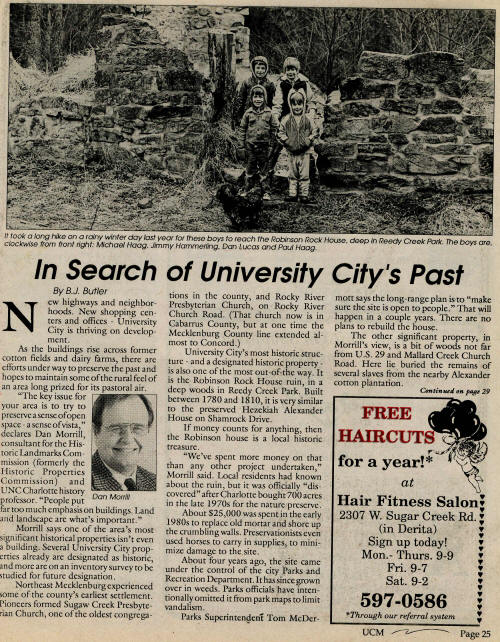
Charlotte’s historic building inventory received an extraordinary supplement in the winter of 1981 when remnants of a hitherto unknown eighteenth century stone dwelling were discovered within present day municipal boundaries. Rare indeed are examples of stone buildings erected by pioneer settlers in Mecklenburg County. Thus, the find is an event of marked significance and unique importance in the architectural history of this community. Cut into a gently sloping hillside among the headwaters of historic Reedy Creek, scattered foundation stones outline graphically the size and shape of the original house. Stones of various sizes and shapes lie in disarray inside the foundation walls and conceal the earth as well as any wood, iron or glass fragments which might remain from the original house. Somewhat smaller than neighboring contemporary stone houses of Hezekiah Alexander and Ezekial Wallace, the dwelling is a modest version of the remarkable wilderness architecture created by hardy immigrants who brought the style from their homes in Maryland and Pennsylvania. The abandoned house had few visitors during most of this century. Its remote location was protection against vandals and souvenir seekers, but not against the ravages of time and nature. Storms and falling trees have inflicted major damage on the structure.
The decaying trunk of a huge elm spans the rear half of the house, where it fell long ago. This falling monster devastated most exterior walls and all of the original wood, roof and floor systems. So complete was the damage that little evidence is visible to tell of the roof, side wall, or chimney forms. Now only one lone section of original masonry rises higher than a few feet above piles of stone rubble which surround the foundation. At the southeast corner of the house is a wall, twenty feet above grade at its highest, which includes wide parts of the original south and east facades. These remaining wall panels are large enough to illustrate the skill of the artisans who built the house. The masonry closely resembles the stone work in the companion Wallace and Alexander dwellings. Wail surfaces are random coursed ashlar with small chip infill fragments used here and there in widening joints. The extraordinary stone work is carefully executed with precise corner faces worked alignment, consistently horizontal jointing and wall into a uniform plane. Stones are of various sizes, averaging perhaps two to three square feet in surface area. Occasionally larger pieces were used, and one at the base of the south wall is a massive unit six feet long and a foot high. Initial compass readings indicate that the structure was placed on an exact north-south magnetic orientation. From its site a few yards north of Reedy Creek, the main facade faces south, consistent with the custom of the time. This south wall is thirty three feet across and appears to have been three bays wide. In this existing stone work, where wood jambs were installed, are straight vertical edges and three openings spaced equally. This pattern hints of a center entrance flanked by single windows.
In the remains of the north wall is evidence of three similar openings where tumbling stones still reveal a center door and side windows. No evidence indicates any side wall openings. Exterior dimensions of the house are thirty three by twenty nine feet. The stone foundation walls are two feet thick from the ground to the first floor. At this level a narrow water table bands the house on all four sides. On the south the ledge is about three feet above grade. Sloping up along each side the ground is less than a foot below the water table along the north side. Inside surfaces of the wall remnants show narrow ledges at two levels. These offsets coincide with the support pattern which would have been needed for wood floor joists. At the first floor the support ledge is approximately nine inches below the water table. For the second floor the offset is about nine feet higher. The level of the two ledges offers strong evidence of the original floor to floor distance, as well as the methods of construction used by the builders. At each offset the exterior wall thickness is reduced about four inches. So from a two foot thick foundation, the walls narrow to less than sixteen inches thick above the second floor. Exposure to weathering has stripped the existing interior wall surfaces of all visible evidence of original finishes. This stone work is a motley array of uncoursed random ashlar and rubble, and appears to be quite unsuitable for exposure to view. The surfaces are, however, laid up on a fairly uniform plane, as if in preparation for plaster or wood covering. Where the original walls remain intact at the southeast corner there are carefully fitted quoins from the ground up.
Shaped from granite pieces which vary in thickness from six to twelve inches, the long dimension of the stones change direction as the courses rise. This pattern of headers and stretchers gave added strength to the walls, while at the same time contributing to the very real beauty of the stone work. Lying slightly askew at the base of the south foundation are several large stones. Flattened on top and roughly cut into long rectangles, these blocks appear to have been steps. When stacked they reached to the top of the water table, or to the level of the original first floor. A brief tour of the wooded area surrounding the stone ruins reveals little clear evidence of original outbuildings. Such remains, if any, are concealed below decaying growth and accumulating humus from the years when no one was about. But the farm yard is not barren. There are two locations where wide, flat stones show evidence of special use. On one such stone, which measures about four feet across, there is a pattern of shallow veed grooves radiating out from an edge notch in a series of branches as if to collect liquid. This stone is some fifty feet south of the house under a huge old poplar and rests among a ride scattering of smaller stones. Off to the west, also about fifth; feet from the house, is another, somewhat smaller flat grooved stone. On this remnant veed grooves follow a fanlike pattern and radiate also from an edge notch. Smaller stones are scattered here also. There are several other nearby piles of rubble and shaped stone — the likely sites of small wood buildings for farm activities. A few paces east of the house ruins is a continuous depression much like an old road bed. This lane approaches from the north and runs southward past the house toward Reedy Creek. Recent dredging has disturbed the creek banks and removed signs of the earlier ford, if one in fact existed.
Conclusion
Settlement along Rocky River and its tributaries came early in the eighteenth century, and this fine stone dwelling appears to have been part of that wilderness venture. The house was likely built by John Robison in the 1780’s on crown grant land passed to him by his father, Robert. The original structure, while quite fine and substantial when compared with many of the other pioneer houses along the Catawba and Rocky Rivers, is yet not among the finest homes of the time and place. So one must judge John Robison’s affluence as limited. The Robison stone house probably followed in many ways the patterns found in contemporary dwellings erected nearby. The size is of primary importance if one is to make assumptions about the original plan and details, however. Rather than incorporating the popular center hall plan, it is likely that the house had two, perhaps three rooms on each floor and entrance at the front and rear was directly into one such room. At one corner there was probably a winding stair, at least partially enclosed, with storage below. On the end wall opposite the stair was a large stone chimney for fireplaces on both floors. Perhaps there were corner angle fireplaces on both floors. The house is hardly large enough for chimneys at each end. Above the second floor there was a garret with a steep winding stair. Headroom was sufficient for storage — even sleeping. Pole rafters probably formed a ridge with the long dimension of the house, and end wall gables were either stone or wood — stone being the more likely. The only openings in the end walls were small garret vents high in the gables. No windows were here — the openings sealed with wood blinds when necessary. Modest, yet meticulously crafted was the character of the Robison stone house. Trim was fabricated carefully, stone work skillfully executed and finishing details proudly done. This was the dwelling of people who were determined to retain a higher life style than the primitive wilderness might dictate.